Incident Media Photographs
Could not determine your location.
South Slope / Roza Slope
Unit Information
Incident Contacts
- Ben ShearerEmail:Phone:509 492 1461
Photographs Gallery

South Slope Roza Slope
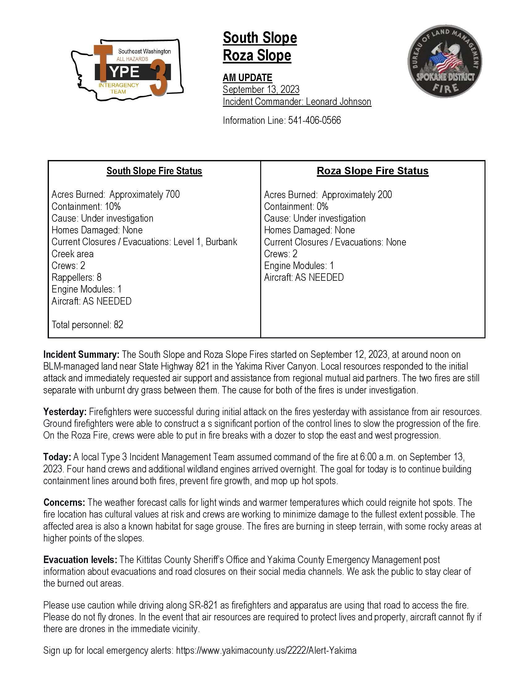
AM UPDATE
September 13, 2023
Incident Commander: Leonard Johnson Information Line: 541-406-0566
Roza Slope Fire Status
Acres Burned: Approximately 200
Containment: 0%
Cause: Under investigation
Homes Damaged: None
Current Closures / Evacuations: None
Crews: 2
Engine Modules: 1
Aircraft: AS NEEDEDSouth Slope Fire Status
South Slope Fire Status
Acres Burned: Approximately 700 Containment: 10%
Cause: Under investigation Homes Damaged: None
Current Closures / Evacuations: Level 1, Burbank Creek area
Crews: 2
Rappellers: 8
Engine Modules: 1 Aircraft: AS NEEDED
Total personnel: 82
Acres Burned: Approximately 200 Containment: 0%
Cause: Under investigation Homes Damaged: None
Current Closures / Evacuations: None Crews: 2
Engine Modules: 1 Aircraft: AS NEEDED
Incident Summary: The South Slope and Roza Slope Fires started on September 12, 2023, at around
noon on BLM-managed land near State Highway 821 in the Yakima River Canyon. Local resources
responded to the initial attack and immediately requested air support and assistance from regional
mutual aid partners. The two fires are still separate with unburnt dry grass between them. The
cause for both of the fires is under investigation.
Yesterday: Firefighters were successful during initial attack on the fires yesterday with
assistance from air resources. Ground firefighters were able to construct a s significant portion
of the control lines to slow the progression of the fire. On the Roza Fire, crews were able to put
in fire breaks with a dozer to stop the east and west progression.
Today: A local Type 3 Incident Management Team assumed command of the fire at 6:00 a.m. on
September 13, 2023. Four hand crews and additional wildland engines arrived overnight. The goal for
today is to continue building containment lines around both fires, prevent fire growth, and mop up
hot spots.
Concerns: The weather forecast calls for light winds and warmer temperatures which could reignite
hot spots. The fire location has cultural values at risk and crews are working to minimize damage
to the fullest extent possible. The affected area is also a known habitat for sage grouse. The
fires are burning in steep terrain, with some rocky areas at higher points of the slopes.
Evacuation levels: The Kittitas County Sheriff’s Office and Yakima County Emergency Management post
information about evacuations and road closures on their social media channels. We ask the public
to stay clear of the burned out areas.
Please use caution while driving along SR-821 as firefighters and apparatus are using that road to
access the fire. Please do not fly drones. In the event that air resources are required to protect
lives and property, aircraft cannot fly if there are drones in the immediate vicinity.
Sign up for local emergency alerts: https://www.yakimacounty.us/2222/Alert-Yakima
###

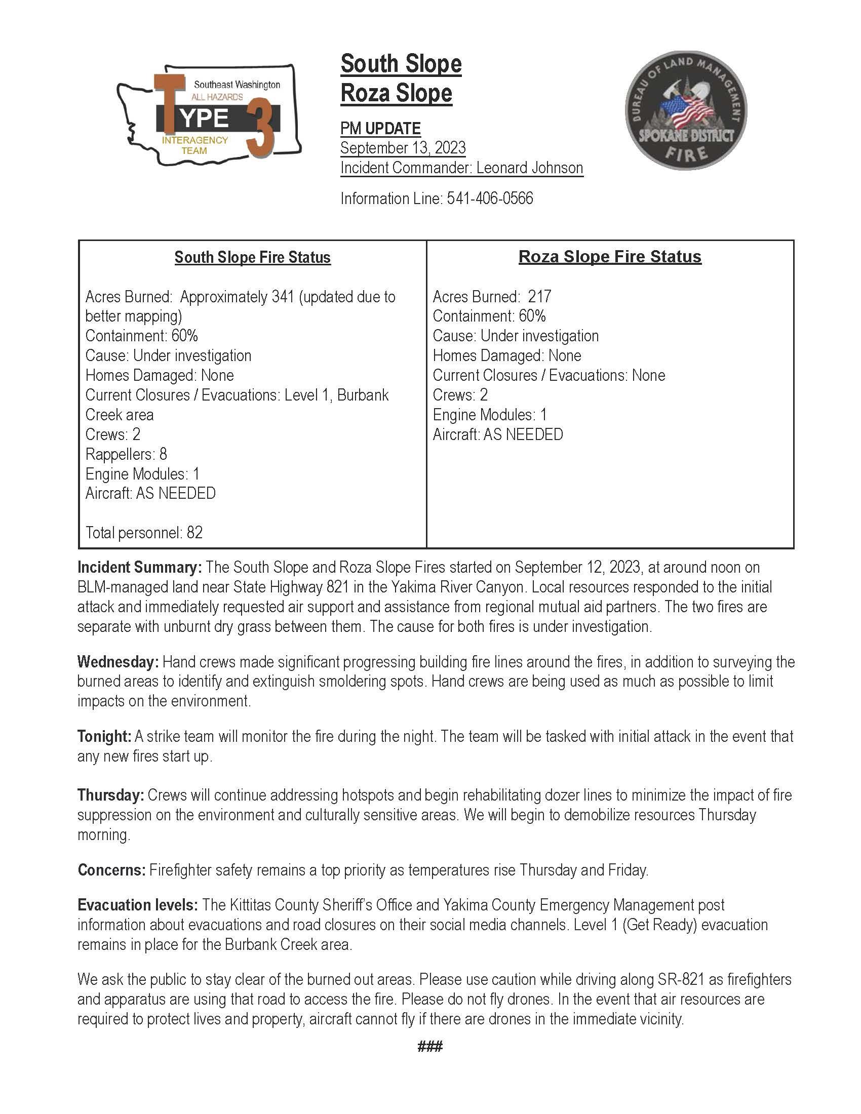
South Slope
Roza Slope
PM UPDATE
September 13, 2023
Incident Commander: Leonard Johnson
Information Line: 541-406-0566
South Slope Fire Status
Acres Burned: Approximately 341 (updated due to
better mapping)
Containment: 60%
Cause: Under investigation
Homes Damaged: None
Current Closures / Evacuations: Level 1, Burbank
Creek area
Crews: 2
Rappellers: 8
Engine Modules: 1
Aircraft: AS NEEDED
Total personnel: 82
Roza Slope Fire Status
Acres Burned: 217
Containment: 60%
Cause: Under investigation
Homes Damaged: None
Current Closures / Evacuations: None
Crews: 2
Engine Modules: 1
Aircraft: AS NEEDED
Incident Summary: The South Slope and Roza Slope Fires started on September 12, 2023, at around noon on BLM-managed land near State Highway 821 in the Yakima River Canyon. Local resources responded to the initial attack and immediately requested air support and assistance from regional mutual aid partners. The two fires are separate with unburnt dry grass between them. The cause for both fires is under investigation.
Wednesday: Hand crews made significant progressing building fire lines around the fires, in addition to surveying the burned areas to identify and extinguish smoldering spots. Hand crews are being used as much as possible to limit impacts on the environment.
Tonight: A strike team will monitor the fire during the night. The team will be tasked with initial attack in the event that any new fires start up.
Thursday: Crews will continue addressing hotspots and begin rehabilitating dozer lines to minimize the impact of fire suppression on the environment and culturally sensitive areas. We will begin to demobilize resources Thursday morning.
Concerns: Firefighter safety remains a top priority as temperatures rise Thursday and Friday.
Evacuation levels: The Kittitas County Sheriff’s Office and Yakima County Emergency Management post information about evacuations and road closures on their social media channels. Level 1 (Get Ready) evacuation remains in place for the Burbank Creek area.
We ask the public to stay clear of the burned out areas. Please use caution while driving along SR-821 as firefighters and apparatus are using that road to access the fire. Please do not fly drones. In the event that air resources are required to protect lives and property, aircraft cannot fly if there are drones in the immediate vicinity.
###

 InciWeb