Incident Media Maps
Could not determine your location.
Maps Gallery

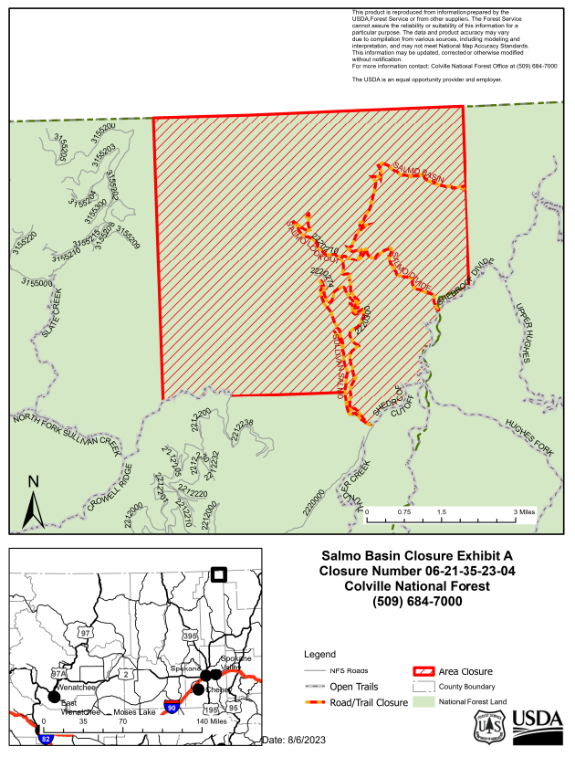
CLOSURE AREA DESCRIPTION:
Starting in T40N R45E S31 at the SW corner of the section the closure boundary follows the Township line North to the NW corner of section 6 at the Canadian Border. The closure boundary then follows the Range line East along the Canadian Border to the NE corner of Section 1 at the Idaho Border, and then follows the Township line South along the Washington/Idaho Border to the Shedroof Divide Trail #512. From there, the closure boundary follows the Shedroof Divide Trail #512 South to the Shedroof Cutoff Trail #511, and then the Shedroof Cutoff Trail #511 to NFS Road 2220000. The closure boundary then follows NFS Road 2220000 North to T40N R45E S34, and from there follows the Range line in Section 34 West to the Bear Pasture Trailhead and Crowell Ridge Trail #515, then follows the Crowell Ridge Trail #515 West to the SW Quarter of Section 31, and then follows the Range line in Section 31 West back to the beginning location. All NFS roads, trails and land within the lines described above are included in the closure area. No State DNR or Private lands or roads are closed under this order.
Closed Trails:
Salmo Divide Trail #535
Salmo Basin Trail #506
Salmo Cabin Trail #531
Closed Roads:
NFS Road 2220000/Sullivan-Salmo Rd
NFS Road 2220270/Salmo Lookout Rd
NFS Road 2220274
NFS Road 2220300

 InciWeb