
Highlighted Activity
Highlighted Media
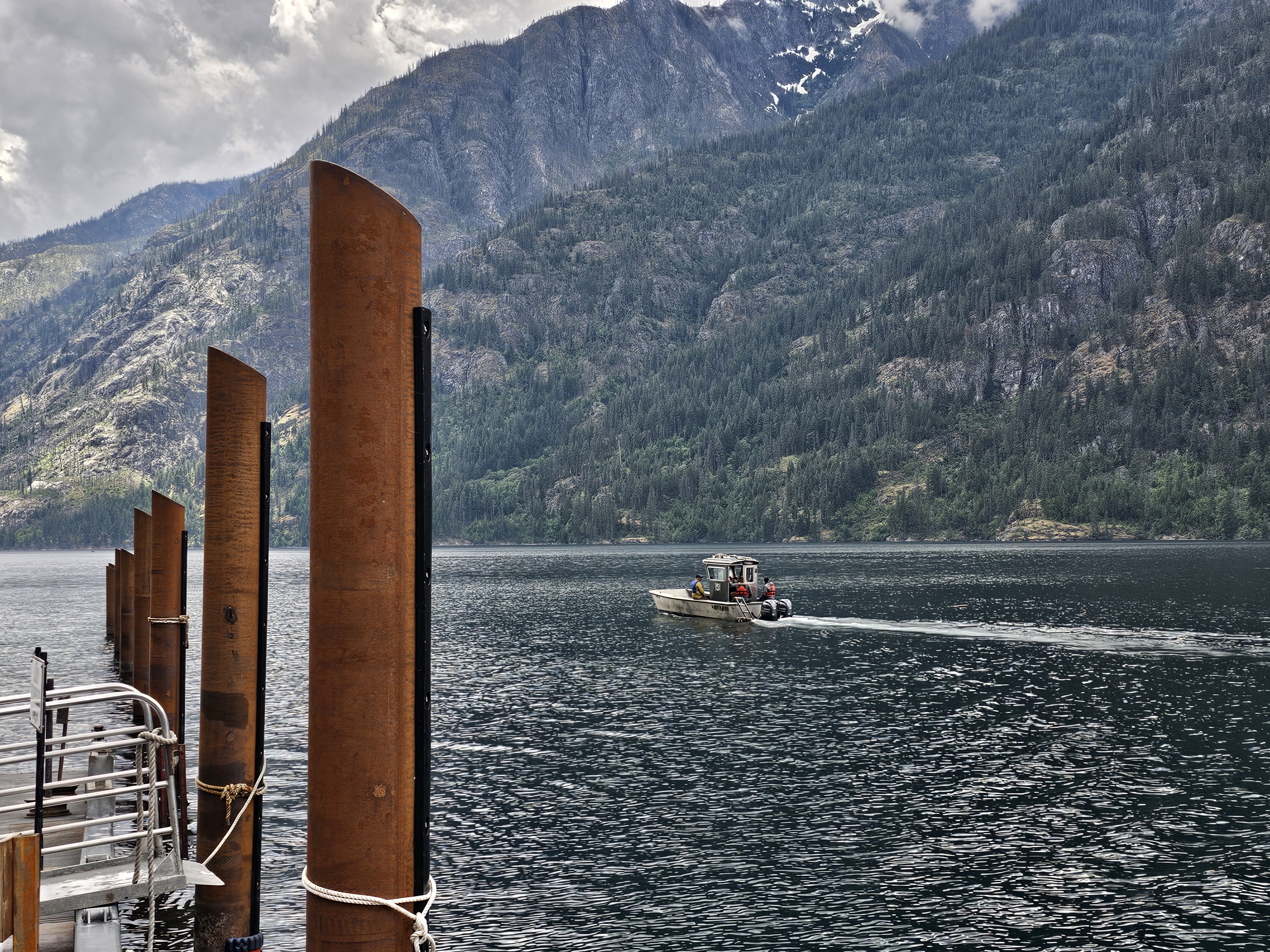
A fishing boat transports firefighters on Lake Chelan

Pioneer Fire is burning on steep, rugged slopes with limited access near the north shore of Lake Chelan. Fire personnel are accessing the fire by boat and helicopter, and are working to establish fire lines and hose lays to stop the fire's spread. Aerial resources are being used to drop water on the fire and to monitor fire activity and movement.
The USFS has updated their closure order for the area around Pioneer Fire. Please see the Closures tab for more information.
Chelan County has updated their evacuation orders for areas around the fire. Please check the Announcements tab for the latest information.
The National Park Service has issued a closure order for Lakeshore Trail from Stehekin to Flick Creek Campsite, and for Flick Creek Campsite. Please see the Closures tab for more information.
| Current as of | Wed, 07/03/2024 - 15:32 |
|---|---|
| Incident Time Zone | America/Los_Angeles |
| Incident Type | Wildfire |
| Cause | Undetermined |
| Date of Origin | |
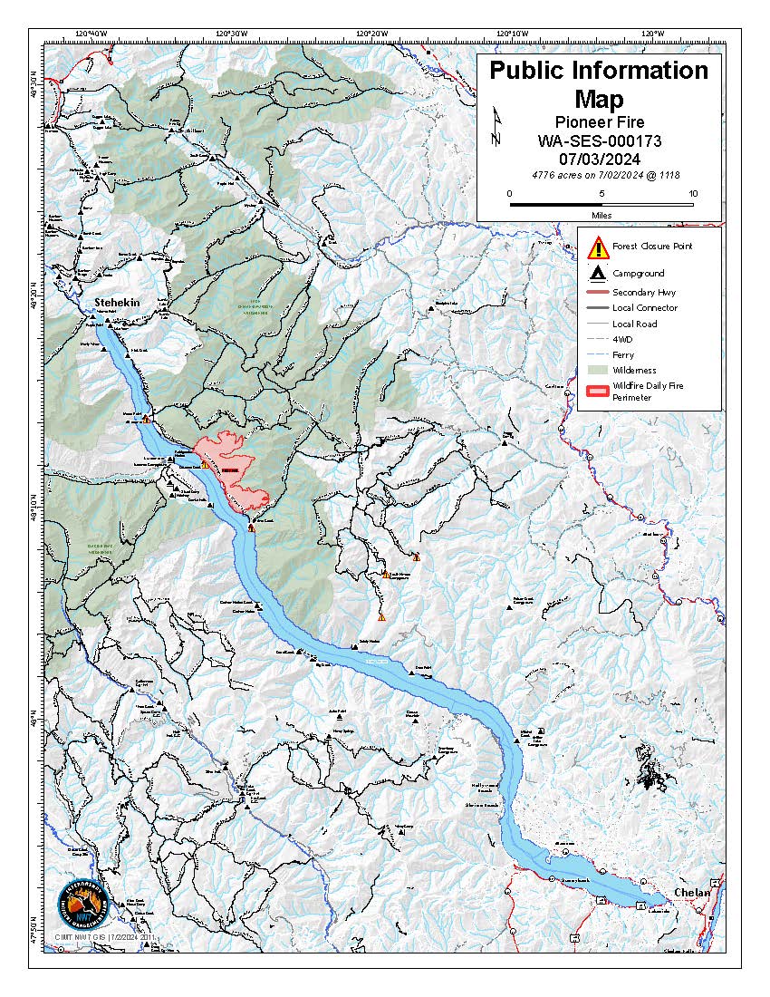
| Location | 10 miles southeast of Stehekin, WA |
| Incident Commander | Nate LeFevre - Incident Commander Chris Orr- Deputy Incident Commander Northwest Complex Incident Management Team 7 |
| Coordinates |
48° 10' 57'' Latitude
-120° 31' 51
'' Longitude
|
| Total Personnel: | 553 |
|---|---|
| Size | 4,776 Acres |
| Percent of Perimeter Contained | 14% |
| Estimated Containment Date | 10/31/2024 |
| Fuels Involved | Timber (Grass and Understory) Short Grass (1 foot) Timber (Litter and Understory) The Pioneer incident is within the footprint of the 2001 Rex Creek burn. Abundant snags, heavy downed woody material, grasses, young conifer stands, and shrub patches occupy the area. The area is a mosaic of fuel patches with rock scree and outcrops serving as partial barriers to fire spread. Grasses are mostly cured, while shrubs and herbaceous materials are seasonally moist. Timber litter fuels are patchy and dry. |
| Significant Events | Observed fire behavior: Moderate, Flanking, Backing Creeping Cool northwesterly flow with moderate relative humidity continues to moderate fire activity on the Pioneer incident. The fire remains within the Rex Creek (2001) fire footprint, with ample evidence of past large fires in the area. Current fire activity in the headwaters of Meadow and Cascade Creeks on the north flank has been diminished by helicopter bucket drops. Fire spread is limited due to seasonal conditions, and lack of strong lake winds. Prince Creek fire activity is primarily confined to extremely steep slopes north of the creek. A helicopter rappel crew was inserted above Prince Creek to construct segments of fireline between rock barriers, and direct bucket drops. General fire behavior includes minimal flanking laterally across slopes, downslope backing with burning material rolling down steep rocky slopes, and creeping. Lake Chelan's winds and steep topography are contributing to suppression challenges. |
| Planned Actions |
Based on current and forecasted weather, Branch I continues to protect critical values along Lake Chelan shoreline outside of NPS jurisdiction. Branch II continues structure assessment and community protection in Stehekin and NPS jurisdiction. Divisions A and Z are implementing direct and indirect fire line control features from Canoe Creek to Meadow Creek in the Chelan-Sawtooth Wilderness Area to limit risk to values by checking fire growth along lake Chelan. Evaluations of direct line contruction in Prince Creek as well as Meadow Creek. |
|---|---|
| Projected Incident Activity |
12 hours: Warm and dry weather with breezy NW winds is accelerating drying in surface fuels. Fuels will dry out to allow fire spread where heat sources are present. Expect continued backing (with rollout), flanking, and short head fire spread on the upper slopes north of Prince Creek A helicopter rappel crew has been inserted above Prince Creek to construct firelines connecting rock barriers, and direct bucket drops. The headwaters of Meadow Creek will continue to smolder as control lines are constructed by a rappel crew along with additional helicopter bucket drops. 24 hours: Very warm and dry conditions with breezy NW winds will support active fire spread where fuel and a sources of ignition are present. Isolated areas of the fire may continue to produce backing (with rolling materials), flanking, and limited upslope fire spread. Potential for short upslope fire runs in areas where fuel pockets are continuous between rock barriers. Expecting 48 hours: High temperatures and low relative humidity with a diurnal up/down lake wind flow pattern will produce conditions favorable for active fire spread. Residual sources of heat likely cause fire spread when they encounter unburned fuels. Interior heat sources will continue to retain heat and consume in-place creating additional smoke. Some interior fuel pockets may produce 72 hours: High pressure pattern continues with very warm and dry conditions. Fuels will have sufficiently dried allowing fire spread where sources of ignition are present. Combination of wind and slope alignment will contribute to suppression challenges on new ignitions in the area. Fire spread rates and intensity may allow large acreage increases on the current fire and any new ignitions in the area. Anticipated after 72 hours: Temperatures are expected to rise into the 90's, with relative humidity near 15% resulting in conditions that may support large fire, growth and high intensity fire behavior. The hot and dry weather coupled by dry fuels may produce significant suppression challenges in steep topography. |
| Remarks |
Complex Incident Management Northwest Team 7 assumed command on the incident on June 25, 2024 at 0600. |
| Weather Concerns | Another day of northwest flow occurred over Lake Chelan and the Pioneer fire area. Dry air aloft that moved to the southwest of the region promoted slightly higher temperatures in the upper 70s and low 80s and lower relative humidity values over the incident area (low 20% range) and in Chelan. Winds in the valleys, midslopes, and ridges experienced gusts between 20 and 30 mph. Strong down As high pressure slowly builds in from the southwest, Wednesday will feature warmer temperatures in the low to mid 80s and relative humidities around 20 percent. Locations closer to Chelan and at lower elevations away from the lake are more likely to experience further drops in relative humidity into the upper teens. Temperatures are expected to rise considerably into the late week and weekend, forecast to be in the mid to upper 90s over the holiday weekend. |
|---|