
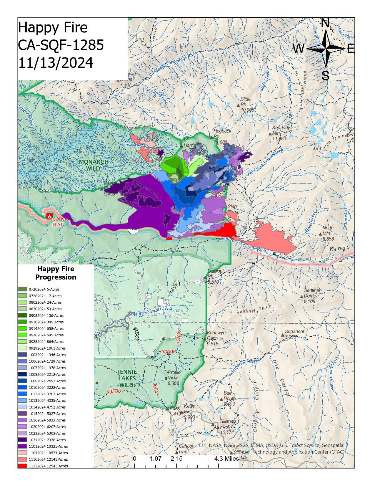
The Happy Fire, which is a lightning fire discovered on 7/16/2024, burning within the Monarch Wilderness and within the 2015 Rough Fire footprint.
KINGS CANYON NATIONAL PARK CLOSURES: 1. Hotel Creek Trail from the overlook junction to the Lewis Creek Trail, and 2. The area west of the line that follows the Lewis Creek Trail (inclusive) bounded by the road to the south; to the junction of the trail with Lewis Creek/East Lewis Creek; along the creek to the point of origin of the East Fork of Lewis Creek; in a straight line back to the Lewis Creek Trail; along the trail to Kennedy Pass; along the ridge west to the boundary with Sequoia National Forest; south along the boundary back to the road (excluded); along the road (excluded) back to the point of beginning, as shown on the attached map.
| Current as of | Thu, 11/14/2024 - 20:18 |
|---|---|
| Incident Time Zone | America/Los_Angeles |
| Incident Type | Wildfire |
| Cause | Lightning/Natural |
| Date of Origin | |
| Location | Monarch Wilderness North of the Kings River |
| Incident Commander | USFS Local Team |
| Coordinates |
36° 50' 7'' Latitude
-118° 44' 41
'' Longitude
|
| Total Personnel: | 45 |
|---|---|
| Size | 12,543 Acres |
| Percent of Perimeter Contained | 65% |
| Fuels Involved | The fire is burning within the 2015 Rough Fire Scar. Timber (Grass and Understory) Brush (2 feet) Short Grass (1 foot)
|
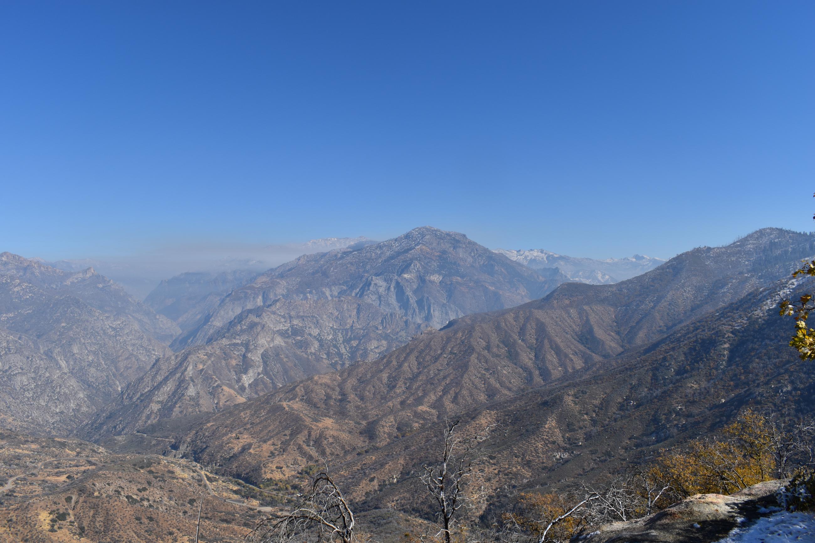
| Significant Events | There has been light smoke visible in the Silver Creek Drainage on the Sierra National Forest side of the Monarch Wilderness divide along with intermittent smokes along State Highway 180 corridor and the Cedar Groves areas located inside Sequoia and Kings Canyon National Park. The ongoing monitoring of the fire ensures that any potential risks are identified and managed effectively. The fire will be monitored until rainfall and winter-like conditions put it out. Fire continues to burn within the 2015 Rough Fire scar. |
| Planned Actions |
Secure the fire along Highway 180 and minimize upslope runs into timber stringers within the park boundary. |
|---|---|
| Projected Incident Activity |
12 hours: Expected additional growth in the Silver Creek Drainage on the Sierra National Forest side of the Monarch Wilderness Divide. 24 hours: Light activity over the last half of this week. 48 hours: Fire patrol status. 72 hours: Minimal movement due to potential cloud cover and cooler temperatures. |
| Remarks |
2,262 ACRES on Sequoia & Kings Canyon National Parks (CA-KNP) 556 ACRES on Sierra National Forest (CA-SNF) 9,725 ACRES on Sequoia National Forest (CA-SQF) |
| Weather Concerns | Another winter storm is expected over the fire area Thursday night into Friday. Precipitation models show as much as 4-6 inches of new snow above 5000 feet with potential for snow levels as low as 4000 feet. |
|---|