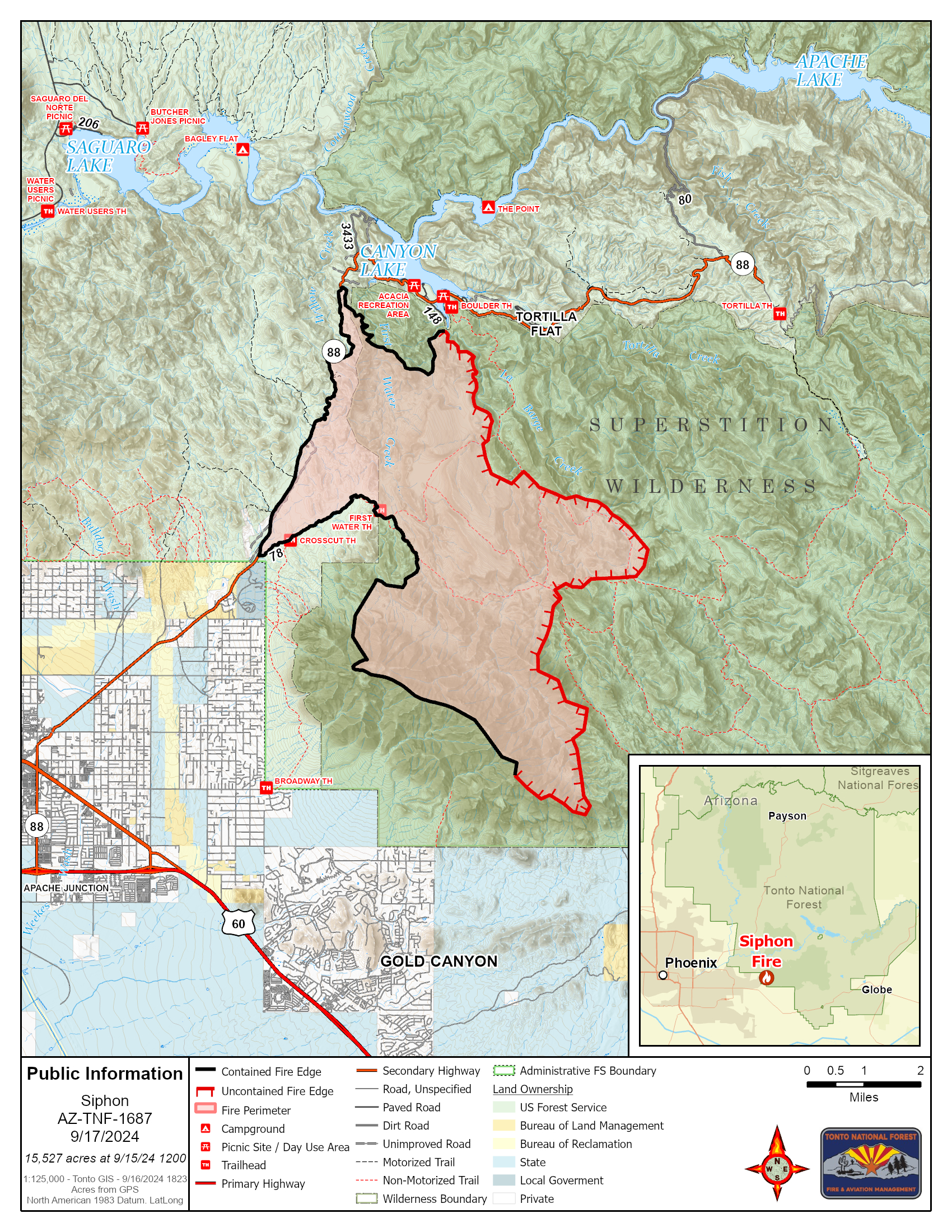
U.S. flag

An official website of the United States government

Here's how you know

Single Incident Information

Zoom to your location
Reset map zoom and position

Could not determine your location.

Siphon Fire

Share this incident

Unit Information

2324 E. McDowell Rd 
Phoenix, 
85006 
2324 E. McDowell Rd 
Phoenix, 
85006 

Incident Contacts

Susan Blake
Email: susan.blake@usda.gov
Phone: 480-647-8082
Hours: 0900-1600

Highlighted Activity

Fire officials have estimated the #SiphonFire at approximately 15,875 acres with 0% containment. Yesterday, super scoopers conducted water drops to limit the spread of the fire near Weaver’s Needle as the southeast side of the fire was active. The southwest flank of the fire saw very little growth. Today, crews will be monitoring and improving fire lines along SR 88 (Apache Trail). An overflight… Read more
Publication Type: News -
Yesterday's overflight mapped the #SiphonFire at 15,837 acres with 27% containment. Today, crews will be patrolling, monitoring and continuing to improve existing firelines. Thunderstorms and rain are expected to increase to 50 percent by Sunday afternoon. Temperatures are expected to lower with increasing relative humidity into Monday. There are 102 personnel assigned to the fire including 3… Read more
Publication Type: Announcement -

Highlighted Media

Fire crews are responding to the Siphon Fire on the Mesa Ranger District in the Superstition Wilderness northeast of Apache Junction. MCSO is evacuating Canyon Lake/Tortilla Flat area along SR 88. Take prescriptions, water, snacks, identification and pets. Avoid this area & follow directions of emergency personnel. The cause remains under investigation. Due to the rugged terrain, ground resources cannot safely access the fire. The public is urged to avoid SR 88 while fire suppression operations are being conducted. More resources are on order. Residents in the area should remain aware, follow the fire updates and messaging from other local emergency agencies. Residents are urged to sign up for Ready, Set, Go emergency alerts with their counties:  https://ready.maricopa.gov/999/Emergency-Management


Basic Information
Current as of Sun, 09/15/2024 - 15:21
Incident Time Zone America/Phoenix
Incident Type Wildfire
Cause Human-caused, under investigation
Date of Origin
Location Siphon Draw and Flatiron in Superstition Wilderness
Incident Commander Benjamin Stewart, Type 3 IC
Incident Description The Siphon Fire is a human-caused fire currently under investigation. The fire is burning in the Superstition Wilderness.
Coordinates 33° 26' 34'' Latitude
-111° 26'
48
'' Longitude
Current Situation
Total Personnel: 102
Size 15,837 Acres
Percent of Perimeter Contained 27%
Estimated Containment Date 9/30/24
Fuels Involved

Sonoran Desert lowlands with Pinyon and Juniper at the Highest Elevations. 

Significant Events

Yesterday's overflight mapped the #SiphonFire at 15,837 acres with 27% containment. Today, crews will be patrolling, monitoring and continuing to improve existing firelines. Thunderstorms and rain are expected to increase to 50 percent by Sunday afternoon. Temperatures are expected to lower with increasing relative humidity into Monday. There are 102 personnel assigned to the fire including 3 hand crews, 11 engines and 2 water tenders. The public is advised to avoid the First Water, Boulder, Siphon Trails and Forest Road 78 while the Siphon Fire is active.

The GO order is still in effect for SR 88 (Apache Trail) and the roadblock was moved to Mile Marker 203.5 at Needle Rock Vista. There is no access to Tortilla Flat and Canyon Lake Marina and along SR 88 where Maricopa County has placed a GO order for people to evacuate while firefighters are conducting suppression operations for the #SiphonFire.

Outlook
Planned Actions

Patrol, monitor, and continue to improve existing control features. Evaluating for suppression repair. Reevaluate all ready-set-go status for affected communities.

Projected Incident Activity

12 Hours: As containment increases and fire activity decreases, plan for reopening of closed areas. Reevaluate all Ready-Set-Go status for communities. 

24 Hours: As containment increases and fire activity decreases, plan for reopening of closed areas. Reevaluate all Ready-Set0Go status for communities. 

48 Hours: As containment increases plan for demobilization of resources. 

72 Hours: No threats expected. 

Anticipated after 72 Hours: No threats expected. 

Current Weather
Weather Concerns

Thunderstorms and rain are expected to increase to 50 percent by Sunday afternoon. Temperatures are expected to lower with increasing relative humidity into Monday.