
Tiger Island Fire Update 91823
Related Incident: Tiger Island Fire
Publication Type: News
Louisiana Statewide Burn Ban: The State Fire Marshal’s Office’s order prohibiting ALL private burning and the Louisiana Department of Agriculture and Forestry ban on all agricultural burning, remain in effect. These are reevaluated weekly. Open burning with exposed flames is prohibited with no exceptions. The use of prescribed fires is also banned. More information is available at http://sfm.dps.louisiana.gov/doc/press/pr_2023-36.pdf
Highlights: Yesterday’s events included a sizable spot on the Tiger Island Fire on the south end of the incident. Large Air Tankers, Scooper Planes and helicopters aided ground crews with dozers and plow units to get a fireline around the spot which crossed Hwy 110. The highway was temporarily closed for public safety. Ground crews worked late into the night to stop the fire’s progression. The drying trend continues and reburn of needle cast was occurring on the Hwy 113 Fire but stayed within the original footprint as currently mapped. Crews continue to monitor, suppress reburn, patrol containment lines and remove any needle cast along all control lines on all of the fires. Archery deer season has commenced, so hunter and firefighter safety will be paramount. With more people in the fire area this weekend, extra caution is required if you are hunting in or near the fire areas.
Tiger Island Fire: 31,087 acres, no change (The spot fire is not yet mapped but will be reflected in tomorrow’s acreage) | 84% containment| 228 personnel assigned
Inciweb: https://inciweb.nwcg.gov/incident-information/lalas-tiger-island-fire
Facebook: https://www.facebook.com/TigerIslandFire
Hwy 113 Fire: 7,124 acres, no change | 95% containment | 71 personnel assigned
InciWeb: https://inciweb.nwcg.gov/incident-information/lalas-hwy-113-fire
Facebook: https://www.facebook.com/TigerIslandFire
Lions Camp Road Fire: 785 acres, no change | 91% containment | 22 personnel assigned
InciWeb: https://inciweb.nwcg.gov/incident-information/lalas-lions-camp-road-fire
Facebook: https://www.facebook.com/TigerIslandFire
Elizabeth Fire: 940 acres, no change | 95% containment | 13 personnel assigned
InciWeb: https://inciweb.nwcg.gov/incident-information/lalas-elizabeth-fire
Facebook: https://www.facebook.com/TigerIslandFire
Equipment resources assigned to the fires include Type 6 Engines; Dozers; Tractor Plow Units; and Water Tenders. Aerial resources include helicopters and fixed wing aircraft. Additional support is being provided by Parish authorities and departments; Sheriff’s Offices; and the Governor’s Office of Homeland Security and Emergency Preparedness.
Weather & Fire Behavior: Today’s weather has predicted even lower humidities and temperatures in the 90s, but winds will moderate and be less than yesterday’s gusts. This still means any new fire starts have the potential to move quickly and spread. The incident’s Fire Behavior Analyst gave an example of how fast a fire could spread comparing it to a potential of 5 acres of spread in just 15 minutes. Over a third of the State of Louisiana is experiencing extreme drought conditions and that is not expected to change over the coming weeks.
Air Quality: Smoke may occur in areas of reburn. Air quality information is available at the EPA’s Fire and Smoke Map at: https://fire.airnow.gov/ .
Temporary Flight Restriction: A Temporary Flight Restriction (TFR) is in place over the Tiger Island Fire and Hwy 113 and Elizabeth Fire areas. If you fly, we can’t. Aircraft or drone intrusions into the restricted airspace endangers aircrews conducting fire operations and aerial resources are grounded for safety. This unnecessarily places aircrews and ground fire crews at risk in a dynamic and dangerous fire environment.
Monday September 18 2023 Valentine Fire Update and Map
Related Incident:
Publication Type: News
Size: 3,996 acres
Start Date: August 16, 2023
Cause: Lightning
Completion: 57%
Total personnel: 173
Location: 11 miles northeast of Young, Arizona and 27 miles
east of Payson, Arizona
Fuels: Ponderosa Pine, Hardwood litter and timber
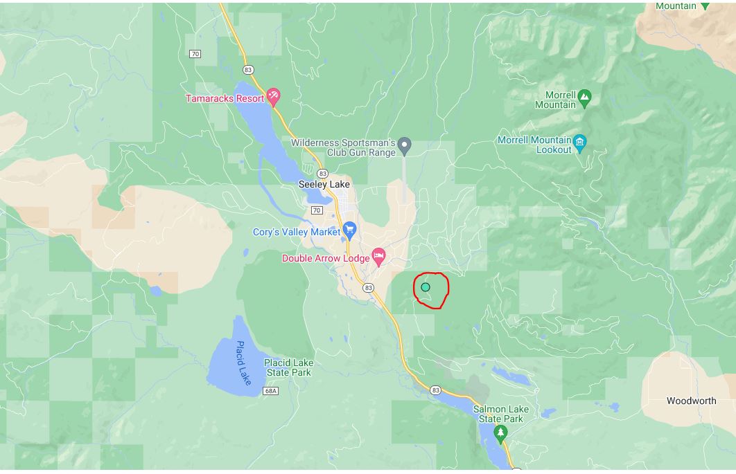
Highlights: Yesterday, as of 6 a.m., Chamberlain Trail Road (FSRD 200) will be closed until 6 p.m. on September 30, 2023 for firefighter and public safety. The communities of Gordon Canyon, 13 Ranch, and The Cove are in SET status. For more information on Ready, Set, Go, please visit: https://ein.az.gov/ready-set-go.
Operations: Yesterday, crews on the northwest end of the fire conducted some hand ignitions, moving west towards the Chamberlain Trail (FSRD 200) building depth; however, conditions were limiting. Tactical firing operations were performed down the drainages from the north to the south towards FSRD 411 building depth and evening out the fire line. Today, crews will continue moving the fire’s edge towards Chamberlain Trail (FSRD 200) along that west fire perimeter line to the south, adding more depth.
Fire Ecology: A crown fire is when a fire burns along the top of trees, also known as the canopy. Crown fires produce high-severity fire effects. The term “torching” refers to when a fire burns the crown of one tree or a small group of trees but does not move around. Surface fire is when the fire stays on the surface, consuming grass and forest litter and reducing the ladder fuels.
Weather: Yesterday, there were scattered storms along the west fire perimeter up to ½”. Today, there is a 10-15% chance of showers with the relative humidity in the teens. Later this week, wind is expected to increase from the southwest, with temperatures expected to continue on a downtrend.
Closures: An emergency closure order for the Valentine Fire has gone into effect as of 6 a.m. Sept. 5, 2023. The public is asked to avoid the fire area. The purpose of the closure order is to protect public health and safety during the Valentine Fire and to protect assigned firefighting personnel engaging in wildland firefighting operations. Signs and gates will be in place to remind the public not to enter the fire area. Please visit the Alerts and Notices page for more information. https://www.fs.usda.gov/alerts/tonto/alerts-notices.
Safety: The health and safety of firefighters and the public are always the highest priority. Members of the public are asked to avoid the fire area.
Smoke: The fire may produce additional smoke due to excessive fuel accumulation. Smoke from the Valentine Fire may be visible in the surrounding areas for many days. Smoke-sensitive individuals and people with respiratory problems or heart disease are encouraged to take precautionary measures. An interactive smoke map at https://www.airnow.gov/wildfires/ lets you zoom into your area to see the latest smoke conditions.
Information Links and Contacts
Tonto National Forest: https://www.fs.usda.gov/main/tonto/fire
InciWeb: https://inciweb.nwcg.gov/incident-information/aztnf-valentine-fire
Fire Email: 2023.valentine@firenet.gov
Fire Information Line: (928)-421-4579 • Office Hours: 8:00 AM – 8:00 PM
September 18 2023 Prescribed Fire Planned
Related Incident:
Publication Type: Announcement
Conditions permitting, Seeley Ranger District plans to burn southeast of Seeley Lake today to help reduce hazardous fuels, restore wildlife habitat, and create better protection around communities from future wildfires.
Seeley Ranger District:
The 80-acre prescribed fire unit is located approximately 2 miles southeast of the community of Seeley Lake; east of Highway 83 between mile markers 10 and 13. Smoke may be visible from Seeley for the duration of the burn.
Firefighters and engines will implement the prescribed burn, patrol, and monitor the burning over the next few days.
Prescribed burning is an important and multipurpose forest management tool that can mimic natural fire by improving healthy forest habitat conditions to benefit wildlife and fire-dependent plant species.
Olympic National Park Fire Update September 17
Related Incident: 2023 Olympic National Park Lightning Fires
Publication Type: News
Port Angeles, Wash. – Fire activity was lower today due to overcast skies and higher humidities. An aerial reconnaissance flight was conducted allowing for updated acreage of all park fires; the Delabarre Fire is approximately 1,500 acres, however, low visibility and low-lying smoke made it difficult for fire personnel to identify the exact perimeter of the fire. A flight tomorrow with infrared mapping technology will provide a more accurate estimate of the fire’s size.
Fire personnel continued to work in the Low Divide area; firefighters have created a defensible space around the Glacier Creek Bridge and installed sprinklers to help protect the bridge and the Low Divide Ranger Station. The Low Divide Fire continues to burn but it has not yet crossed the North Fork Quinault River.
The Eagle Point Fire is in a confine and contain strategy and was mostly inactive today.
Smoke conditions improved across the north Olympic Peninsula as quieter fire conditions generated less smoke.
Acreage for other fires remained the same:
Fire Name
Initial Report
Estimated Size as of 9/5
Location
Hurricane
8/28/23
4 acres
2,000 ft below Hurricane Ridge parking area
Eagle Point
8/28/23
122 acres
~5 miles out Obstruction Point Road
Diamond Mountain
9/1/23
30 acres
3.3 miles NE of
Anderson Pass
Low Divide
9/1/23
274 acres
N. Fork Quinault drainage
Delabarre
9/1/23
Estimated 1,500 acres
3 miles SE of Mount Christie
Martins Lake
9/2/23
93 acres
2 miles NE of Mount Christie
Mount Queets
9/14/23
1 acre
Summit of Mount Queets
Fire is an integral part of the forested ecosystems on the Olympic Peninsula; plants and animals here have evolved with fire for thousands of years. By allowing fires to burn when appropriate, it allows the natural process to continue to occur and it lowers the fire danger in the future. Naturally occurring fires allow forests to be thinned, opening the canopy and allowing sunlight through. Fire also allows for the recycling of nutrients to the soil while reducing the amount of dead, woody debris. This allows for the sprouting and regrowth of plants, shrubs and trees.
Background Information
All seven active fires in Olympic National Park ignited when a series of lightning strikes occurred on the Olympic Peninsula in the afternoon on August 28.
Closures
Due to wildfire activity the following closures are in effect until further notice:
- Elwha River Trail from Whiskey Bend Trailhead to Low Divide
- Bailey Range Traverse beyond Cat Basin
- Long Ridge Trail to Dodger Point
- Hayden Pass Trail
- Dosewallips River Trail from Dose Meadows to Hayden Pass
- Dodger Point Way Trail
- North Fork Quinault Trail from Elip Creek trail junction to Low Divide
- Skyline Trail from Elip Creek Trail junction to Low Divide
- Martin Park Trail
- Obstruction Point Road and Trailhead
Olympic National Park Wilderness Information Center (WIC) will be notifying backcountry permit holders who may be impacted by these closures. Any permit holders who plan to backpack in the above impacted areas should contact the WIC at 360-565-2992 or by emailing OLYM_WIC@nps.gov.
Weather and Fire Behavior
A front will weaken over the area Sunday night for a chance of rain showers. Relative humidity values will increase with the front due to onshore flow into Monday. Winds will shift more north-northwesterly Monday morning and continue through the day.
Information for the Olympic National Park Lightning Fires can be found at: 2023 Olympic National Park Lightning Fires Information | InciWeb (wildfire.gov)
Olympic National Park information: www.nps.gov/olym
Olympic National Forest information: www.fs.usda.gov/olympic
State and county area burn bans: https://ecology.wa.gov/Air-Climate/Air-quality/Smoke-fire/Burn-bans
Elizabeth Fire Daily Update 91723
Related Incident: Elizabeth Fire
Publication Type: News
Louisiana Statewide Burn Ban: The State Fire Marshal’s Office’s order prohibiting ALL private burning and the Louisiana Department of Agriculture and Forestry ban on all agricultural burning, remain in effect. These are reevaluated weekly. Open burning with exposed flames is prohibited with no exceptions. The use of prescribed fires is also banned. More information is available at http://sfm.dps.louisiana.gov/doc/press/pr_2023-36.pdf
Highlights: Archery deer season has commenced, so hunter and firefighter safety will be paramount. With more people in the fire area this weekend, extra caution is required if you are hunting in or near the fire areas. The drying trend continues and reburn of needle cast was occurring on the Hwy 113 Fire. Despite ongoing reburn, all fires continue to stay in their footprint, with no additional acreage being added. Firefighters continue to monitor, suppress reburn, patrol containment lines and remove any needle cast along control lines on all of the fires. Excess resources continue to be demobilized from these incidents, including a Type 1 and Type 2 helicopter. Some of those are being reassigned to LDAF for initial attack in the local area.
Tiger Island Fire: 31,087 acres, no change | 84% containment | 228 personnel assigned (down 22)
Inciweb: https://inciweb.nwcg.gov/incident-information/lalas-tiger-island-fire
Facebook: https://www.facebook.com/TigerIslandFire
Hwy 113 Fire: 7,124 acres, no change | 95% containment (up 6%) | 71 personnel assigned
InciWeb: https://inciweb.nwcg.gov/incident-information/lalas-hwy-113-fire
Facebook: https://www.facebook.com/TigerIslandFire
Lions Camp Road Fire: 785 acres, no change | 91% containment (up 3%) | 22 personnel assigned
InciWeb: https://inciweb.nwcg.gov/incident-information/lalas-lions-camp-road-fire
Facebook: https://www.facebook.com/TigerIslandFire
Elizabeth Fire: 940 acres, no change | 95% containment | 13 personnel assigned
InciWeb: https://inciweb.nwcg.gov/incident-information/lalas-elizabeth-fire
Facebook: https://www.facebook.com/TigerIslandFire
Equipment resources assigned to the fires include Type 6 Engines; Dozers; Tractor Plow Units; and Water Tenders. Aerial resources include helicopters and fixed wing aircraft. Additional support is being provided by Parish authorities and departments; Sheriff’s Offices; and the Governor’s Office of Homeland Security and Emergency Preparedness.
Weather & Fire Behavior: A Red Flag Warning has been issued by the National Weather Service due to high temperatures, low humidity and moderate wind conditions. This means any new fire starts have the potential to move quickly and spread. Extra vigilance is required to prevent any new fires from starting. Over a third of the State of Louisiana is experiencing extreme drought conditions and that is not expected to change over the coming weeks.
Air Quality: Smoke may occur in areas of reburn. Air quality information is available at the EPA’s Fire and Smoke Map at: https://fire.airnow.gov/ .
Temporary Flight Restriction: A Temporary Flight Restriction (TFR) is in place over the Tiger Island Fire and Hwy 113 and Elizabeth Fire areas. If you fly, we can’t. Aircraft or drone intrusions into the restricted airspace endangers aircrews conducting fire operations and aerial resources are grounded for safety. This unnecessarily places aircrews and ground fire crews at risk in a dynamic and dangerous fire environment.
Hwy 113 Fire Daily Update 91723
Related Incident:
Publication Type: News
Louisiana Statewide Burn Ban: The State Fire Marshal’s Office’s order prohibiting ALL private burning and the Louisiana Department of Agriculture and Forestry ban on all agricultural burning, remain in effect. These are reevaluated weekly. Open burning with exposed flames is prohibited with no exceptions. The use of prescribed fires is also banned. More information is available at http://sfm.dps.louisiana.gov/doc/press/pr_2023-36.pdf
Highlights: Archery deer season has commenced, so hunter and firefighter safety will be paramount. With more people in the fire area this weekend, extra caution is required if you are hunting in or near the fire areas. The drying trend continues and reburn of needle cast was occurring on the Hwy 113 Fire. Despite ongoing reburn, all fires continue to stay in their footprint, with no additional acreage being added. Firefighters continue to monitor, suppress reburn, patrol containment lines and remove any needle cast along control lines on all of the fires. Excess resources continue to be demobilized from these incidents, including a Type 1 and Type 2 helicopter. Some of those are being reassigned to LDAF for initial attack in the local area.
Tiger Island Fire: 31,087 acres, no change | 84% containment | 228 personnel assigned (down 22)
Inciweb: https://inciweb.nwcg.gov/incident-information/lalas-tiger-island-fire
Facebook: https://www.facebook.com/TigerIslandFire
Hwy 113 Fire: 7,124 acres, no change | 95% containment (up 6%) | 71 personnel assigned
InciWeb: https://inciweb.nwcg.gov/incident-information/lalas-hwy-113-fire
Facebook: https://www.facebook.com/TigerIslandFire
Lions Camp Road Fire: 785 acres, no change | 91% containment (up 3%) | 22 personnel assigned
InciWeb: https://inciweb.nwcg.gov/incident-information/lalas-lions-camp-road-fire
Facebook: https://www.facebook.com/TigerIslandFire
Elizabeth Fire: 940 acres, no change | 95% containment | 13 personnel assigned
InciWeb: https://inciweb.nwcg.gov/incident-information/lalas-elizabeth-fire
Facebook: https://www.facebook.com/TigerIslandFire
Equipment resources assigned to the fires include Type 6 Engines; Dozers; Tractor Plow Units; and Water Tenders. Aerial resources include helicopters and fixed wing aircraft. Additional support is being provided by Parish authorities and departments; Sheriff’s Offices; and the Governor’s Office of Homeland Security and Emergency Preparedness.
Weather & Fire Behavior: A Red Flag Warning has been issued by the National Weather Service due to high temperatures, low humidity and moderate wind conditions. This means any new fire starts have the potential to move quickly and spread. Extra vigilance is required to prevent any new fires from starting. Over a third of the State of Louisiana is experiencing extreme drought conditions and that is not expected to change over the coming weeks.
Air Quality: Smoke may occur in areas of reburn. Air quality information is available at the EPA’s Fire and Smoke Map at: https://fire.airnow.gov/ .
Temporary Flight Restriction: A Temporary Flight Restriction (TFR) is in place over the Tiger Island Fire and Hwy 113 and Elizabeth Fire areas. If you fly, we can’t. Aircraft or drone intrusions into the restricted airspace endangers aircrews conducting fire operations and aerial resources are grounded for safety. This unnecessarily places aircrews and ground fire crews at risk in a dynamic and dangerous fire environment.
Lions Camp Road Fire Daily Update 91723
Related Incident: Lions Camp Road Fire
Publication Type: News
Louisiana Statewide Burn Ban: The State Fire Marshal’s Office’s order prohibiting ALL private burning and the Louisiana Department of Agriculture and Forestry ban on all agricultural burning, remain in effect. These are reevaluated weekly. Open burning with exposed flames is prohibited with no exceptions. The use of prescribed fires is also banned. More information is available at http://sfm.dps.louisiana.gov/doc/press/pr_2023-36.pdf
Highlights: Archery deer season has commenced, so hunter and firefighter safety will be paramount. With more people in the fire area this weekend, extra caution is required if you are hunting in or near the fire areas. The drying trend continues and reburn of needle cast was occurring on the Hwy 113 Fire. Despite ongoing reburn, all fires continue to stay in their footprint, with no additional acreage being added. Firefighters continue to monitor, suppress reburn, patrol containment lines and remove any needle cast along control lines on all of the fires. Excess resources continue to be demobilized from these incidents, including a Type 1 and Type 2 helicopter. Some of those are being reassigned to LDAF for initial attack in the local area.
Tiger Island Fire: 31,087 acres, no change | 84% containment | 228 personnel assigned (down 22)
Inciweb: https://inciweb.nwcg.gov/incident-information/lalas-tiger-island-fire
Facebook: https://www.facebook.com/TigerIslandFire
Hwy 113 Fire: 7,124 acres, no change | 95% containment (up 6%) | 71 personnel assigned
InciWeb: https://inciweb.nwcg.gov/incident-information/lalas-hwy-113-fire
Facebook: https://www.facebook.com/TigerIslandFire
Lions Camp Road Fire: 785 acres, no change | 91% containment (up 3%) | 22 personnel assigned
InciWeb: https://inciweb.nwcg.gov/incident-information/lalas-lions-camp-road-fire
Facebook: https://www.facebook.com/TigerIslandFire
Elizabeth Fire: 940 acres, no change | 95% containment | 13 personnel assigned
InciWeb: https://inciweb.nwcg.gov/incident-information/lalas-elizabeth-fire
Facebook: https://www.facebook.com/TigerIslandFire
Equipment resources assigned to the fires include Type 6 Engines; Dozers; Tractor Plow Units; and Water Tenders. Aerial resources include helicopters and fixed wing aircraft. Additional support is being provided by Parish authorities and departments; Sheriff’s Offices; and the Governor’s Office of Homeland Security and Emergency Preparedness.
Weather & Fire Behavior: A Red Flag Warning has been issued by the National Weather Service due to high temperatures, low humidity and moderate wind conditions. This means any new fire starts have the potential to move quickly and spread. Extra vigilance is required to prevent any new fires from starting. Over a third of the State of Louisiana is experiencing extreme drought conditions and that is not expected to change over the coming weeks.
Air Quality: Smoke may occur in areas of reburn. Air quality information is available at the EPA’s Fire and Smoke Map at: https://fire.airnow.gov/ .
Temporary Flight Restriction: A Temporary Flight Restriction (TFR) is in place over the Tiger Island Fire and Hwy 113 and Elizabeth Fire areas. If you fly, we can’t. Aircraft or drone intrusions into the restricted airspace endangers aircrews conducting fire operations and aerial resources are grounded for safety. This unnecessarily places aircrews and ground fire crews at risk in a dynamic and dangerous fire environment.
Tiger Island Fire Daily Update 91723
Related Incident: Tiger Island Fire
Publication Type: News
Louisiana Statewide Burn Ban: The State Fire Marshal’s Office’s order prohibiting ALL private burning and the Louisiana Department of Agriculture and Forestry ban on all agricultural burning, remain in effect. These are reevaluated weekly. Open burning with exposed flames is prohibited with no exceptions. The use of prescribed fires is also banned. More information is available at http://sfm.dps.louisiana.gov/doc/press/pr_2023-36.pdf
Highlights: Archery deer season has commenced, so hunter and firefighter safety will be paramount. With more people in the fire area this weekend, extra caution is required if you are hunting in or near the fire areas. The drying trend continues and reburn of needle cast was occurring on the Hwy 113 Fire. Despite ongoing reburn, all fires continue to stay in their footprint, with no additional acreage being added. Firefighters continue to monitor, suppress reburn, patrol containment lines and remove any needle cast along control lines on all of the fires. Excess resources continue to be demobilized from these incidents, including a Type 1 and Type 2 helicopter. Some of those are being reassigned to LDAF for initial attack in the local area.
Tiger Island Fire: 31,087 acres, no change | 84% containment | 228 personnel assigned (down 22)
Inciweb: https://inciweb.nwcg.gov/incident-information/lalas-tiger-island-fire
Facebook: https://www.facebook.com/TigerIslandFire
Hwy 113 Fire: 7,124 acres, no change | 95% containment (up 6%) | 71 personnel assigned
InciWeb: https://inciweb.nwcg.gov/incident-information/lalas-hwy-113-fire
Facebook: https://www.facebook.com/TigerIslandFire
Lions Camp Road Fire: 785 acres, no change | 91% containment (up 3%) | 22 personnel assigned
InciWeb: https://inciweb.nwcg.gov/incident-information/lalas-lions-camp-road-fire
Facebook: https://www.facebook.com/TigerIslandFire
Elizabeth Fire: 940 acres, no change | 95% containment | 13 personnel assigned
InciWeb: https://inciweb.nwcg.gov/incident-information/lalas-elizabeth-fire
Facebook: https://www.facebook.com/TigerIslandFire
Equipment resources assigned to the fires include Type 6 Engines; Dozers; Tractor Plow Units; and Water Tenders. Aerial resources include helicopters and fixed wing aircraft. Additional support is being provided by Parish authorities and departments; Sheriff’s Offices; and the Governor’s Office of Homeland Security and Emergency Preparedness.
Weather & Fire Behavior: A Red Flag Warning has been issued by the National Weather Service due to high temperatures, low humidity and moderate wind conditions. This means any new fire starts have the potential to move quickly and spread. Extra vigilance is required to prevent any new fires from starting. Over a third of the State of Louisiana is experiencing extreme drought conditions and that is not expected to change over the coming weeks.
Air Quality: Smoke may occur in areas of reburn. Air quality information is available at the EPA’s Fire and Smoke Map at: https://fire.airnow.gov/ .
Temporary Flight Restriction: A Temporary Flight Restriction (TFR) is in place over the Tiger Island Fire and Hwy 113 and Elizabeth Fire areas. If you fly, we can’t. Aircraft or drone intrusions into the restricted airspace endangers aircrews conducting fire operations and aerial resources are grounded for safety. This unnecessarily places aircrews and ground fire crews at risk in a dynamic and dangerous fire environment.
Sunday September 17 2023 Valentine Fire Prompts Additional SET Notifications for Gordon Canyon 13Ranch and The Cove
Related Incident:
Publication Type: Announcement
Valentine Fire - "SET" (official notification from GCSO)
Based on a recommendation from Valentine Fire Incident Management. the communities of Gordon Canyon, 13 Ranch, and The Cove have been placed into SET. Firing operations will continue west from Colcord Canyon along a series of dozer lines, handlines. and improved roads south of Colcord Estates toward the Chamberlain Trail. Ignitions are planned to continue for the next several days as firefighters work to reinforce the previously prepped containment lines. As of this notice, the fire remains within the planned containment area, and all lines are holding. Firing operations are part of the strategy where firefighters have a high probability of success, creating a barrier between control lines and the main fire. Firefighters are conducting firing operations as conditions allow them to meet multiple objectives. including removing accumulations of hazardous fuels to reduce the potential for future catastrophic wildfires and benefit overall forest health. Due to the proximity of the containment line and firing operation and the communities, it is important that residents are aware and make preparations to evacuate, if necessary.
When a Set status goes into effect. residents are recommended to prepare and have an emergency go kit ready in the event a Go Status is activated. Keep in mind unique needs for your family or special equipment for pets and livestock. Stay aware of the latest news and information from public safety and public health officials.
For real-time evacuation notifications from Gila County Emergency Management via cellular phone,
landline phone and/or email, please visit: https://gilacountyaz.genasys.com/portal/en-
Incident Information:
https:/ / http://inciweb.wildfire.gov/incident.../aztnf-valentine-fire https://w\vw.facebook.comjTontoNationalForest
Public Information Line: 928-421 -4S79
I
Gila County Emergency Management:
State of Arizona Emergency Information Network (Ready, Set, Go) https:// ein.az.gov/ready-set-go
P.O. Box 311, Globe. AZ85S02 - Phone:(928)425-4449 -Toll Free:(800) 635-8017 - Fax: (928) 425-
S674
108 W.Main St., Payson, AZ85S41- Phone: (928)474-2208-Toll Free: (866) 866-44S2 - Fax: (928)
474-0614
Actualizacin sobre el complejo norte de Smith River 17 de septiembre de 2023
Related Incident: Smith River Complex
Publication Type: News
Actualización sobre el complejo norte de Smith River, 17 de septiembre de 2023
Tamaño: 92,142 total/ 12,460 en Oregón
Fecha de inicio: 15 de agosto de 2023
Ubicación: Grants Pass, OR
Contención: 58%
Personal total: 1,651 para el complejo
Causa: Rayo
Recursos: 44 equipos 11 helicópteros 68 camiones de bomberos 10 buldóceres 25 tanques de agua 14 trituradoras 1 excavadora
Ayer: Aunque el humo no permitió la ayuda de los recursos aéreos durante la mayor parte del día, los equipos en la esquina noroeste del incendio realizaron operaciones de quema hasta el sistema vial en el lado oeste de Taylor Creek. En el extremo norte, los equipos terminaron las operaciones de quema y están neutralizando, monitoreando la zona y trabajando para alcanzar la extinción total. Asimismo, en el extremo este, retiraron cerca de una milla y media de mangueras debido a que hay poco riesgo de actividad del incendio en dicha zona.
Actividades de hoy: Se están realizando operaciones de quema táctica a pequeña escala cerca de Taylor Creek para devolver el fuego a la línea de control. Esto le permite a los bomberos operar de forma segura mientras realizan las actividades de neutralización y mantenimiento de la línea. En el extremo norte del incendio, los equipos mantienen la línea, neutralizan y monitorean la zona, y comienzan a identificar los daños a reparar. Los equipos de reparación de terreno comenzaron las operaciones de tala en la línea de control secundaria en la zona de Monkey Ridge, mientras avanzan los trabajos en la línea de control secundaria del oeste en Forest Road 1106.
Humo: Se sumó el condado de Jackson a la advertencia de calidad de humo vigente en los condados Curry y Josephine que estará en efecto hasta la noche del domingo debido al humo de los incendios de los complejos de Anvil y Smith River. El humo disminuirá hoy en toda la zona, pero se mantendrá un alto nivel de neblina. Algunos niveles de humo pueden cambiar rápido según el clima; consulte las condiciones actualizadas en: https://bit.ly/SWORsmoke
Cierres: El Bosque Nacional Rogue River-Siskiyou emitió una orden de cierre para una zona y un corredor de 400 yardas de ancho a lo largo de las carreteras Forest Road 1106 (al sur de Elk Mountain Road), Forest Road 1205 (Lower Wheeler Road) y Forest Road 1983 (Mt. Emily Road) desde ayer, 14 de septiembre, hasta el 31 de octubre de 2023. Este cierre permite realizar con seguridad las operaciones asociadas al complejo norte de Smith River. Asimismo, se mantienen vigentes los cierres en BLM. Visite bit.ly/RRSNFAlerts o https://www.blm.gov/orwafire para tener más información.
Cierres vehiculares y retrasos: Caltrans en el condado Del Norte emitió un horario de cierre de camino y restricciones de canales en la carretera US-199. Durante los días de semana, se mantendrá una combinación de cierres de caminos y restricciones de canales. Durante el fin de semana, la carretera permanecerá abierta, pero con restricciones de canales y camiones señalizadores, por lo que es probable que el tráfico sea lento. Para tener información específica sobre el acceso a las carreteras, consulte el mapa de Caltrans https://quickmap.dot.ca.gov/ y la página del Departamento de transporte de Oregón https://www.tripcheck.com/. Las fuerzas de seguridad locales recomiendan evitar cualquier traslado no esencial en esta vía. Los programas y aplicaciones de navegación han llevado a los viajeros a zonas activas del incendio. No utilice los caminos del bosque como rutas alternativas.
Evacuaciones: Consulte la página de gestión de incidencias de Rogue Valley y suscríbase para recibir alertas de evacuación y actualizaciones en https://rvem.org/. Aquí también podrá encontrar un mapa interactivo de primera respuesta al incendio con las zonas de evacuación.
Restricciones: Agradecemos que respecte la Restricción temporal de vuelo (TFR, en inglés) vigente para el complejo de Smith River. Mantenga a los drones lejos de las operaciones de extinción y de la zona de TFR. Si usted vuela, nosotros no podemos hacerlo. ¡No sea responsable de suspender una misión contra incendio! Para tener más información sobre la TFR visite https://tfr.faa.gov/.