
Pyramid and Slate Fires Daily Update 08 09 2024
Related Incident: Pyramid and Slate FiresNorth Willamette Complex
Publication Type: News
Current Situation
As of today, the Pyramid, Slate, and Ore Fires will be collectively referred to as the Willamette Complex North.
Pyramid Fire
East of Middle Santiam Wilderness, 1,328 Acres, 31 Percent Contained, Lightning Caused
Yesterday, firefighters focused on holding and securing the fire perimeter and continued mopping up. Crews also scouted and prepared contingency lines in the area northwest of the fire perimeter. Along the southern flank, hotshot crews constructed hand line where it was safe to do so. Today, firefighters continue to mop up and extinguish hot spots.
Slate Fire
5 miles SW of Detroit, 91 Acres, 99 Percent Contained, 65 Personnel, Under Investigation
Crews continue to patrol and secure the fire perimeter. The fire continues to remain contained within the current footprint.
Weather & Fire Behavior
Milder conditions today than yesterday with increasing marine influence. Predicted maximum temperature is 86 to 90 °F in the valleys and 80 to 84 °F on the ridgetops. Predicted minimum relative humidity is 36 to 42 percent in the valleys and 42 to 48 percent on the ridgetops. Conditions will continue to moderate over the next several days. Even so, fire behavior potential will continue to be high because heavy fuels are dry and heavy fuel moistures are slow to change. Enhanced northwest winds will mix out smoke in the afternoon today. Smoke and air quality conditions are available on: AirNow.gov
Evacuations, Closures & Fire Restrictions
On July 17th, the Linn County Sheriff’s Office, in coordination with the Willamette National Forest, issued a Level 3: Go Now Evacuation Alert for the closure area affected. Please refer to the Linn County Fire Map https://tinyurl.com/LinnCoFireMap for full details of the issued evacuation area (which will appear in red). To sign up for evacuation alerts, visit https://www.linnsheriff.org/.
Area, road, trail, and recreation site closures are in effect in the Willamette National Forest. Specific information is posted at https://www.fs.usda.gov/alerts/willamette/alerts-notices/?aid=61574.
Fire restrictions are in effect for Willamette National Forest. Read the complete restrictions at: https://www.fs.usda.gov/alerts/willamette/alerts-notices/?aid=81487.
Wildfires are a no-fly zone for unauthorized aircraft, including drones. If you fly, we can’t. For more information, visit http://knowbeforeyoufly.org.
Smokey Bear turns 80 years old today! Since 1944, Smokey has educated millions of Americans on the importance of wildfire prevention, mitigation, and suppression.
Warner Peak Fire Daily Update 08 09 2024
Related Incident: Warner Peak Fire
Publication Type: News
Warner Peak Fire Daily Update
Friday, August 09, 2024
Location of Origin: 6 miles East of Plush, on the Hart Mountain Antelope Refuge
Start Date: August 5, 2024
Size: 22,974 acres
Percent Contained: 0%
Cause: Undetermined, Under Investigation
Fuels: Brush, Tall Grass
Resources Assigned: 2 Crews, 8 Engines, 3 Helicopters, 8 Single Engine Air Tankers, 1 Type 1 Airtanker, 1 Water Tender
Operations: Firefighters will utilize established roads along the eastern flank to conduct firing operations to reinforce critical perimeters of the fire. Crews will construct direct and indirect primary and secondary containment lines where it is safe to do so. A point protection strategy, which protects specific assets or highly valued resources from the wildfire, is being utilized around private inholding within the Hart Mountain Antelope Refuge.
Closures: The Hart Mountain National Antelope Refuge is closed for the safety of the general public.
Weather: The forecast is calling for a high of 93 degrees, and winds out of the southwest winds 10 to 15 mph. There is a possibility of thunderstorms returning later in the week.
Smoke: Wildfire smoke may impact the community of Plush. Go to fire.airnow.gov/ to see the latest smoke conditions in your community.
Official fire information can be found on these sites:
- Inciweb: https://inciweb.wildfire.gov/incident-information/orfwf-warner-peak
- Hart Mountain National Antelope Refuge: https://www.fws.gov/refuge/hart-mountain-national-antelope
- Oregon Department of Forestry: https://www.oregon.gov/odf/pages/index.aspx
- Fremont-Winema National Forest: https://www.fs.usda.gov/fremont-winema
Actualizacin Sobre El Incendio CourtrockViernes 08 09 2024
Related Incident: Courtrock Fire
Publication Type: News
Las comunidades pueden seguir viendo humo a medida que se queman los materiales dentro del incendio.
Acres: 20,019 acres | Fecha de inicio: 21 de Julio 2024 | Causa: Rayo | Combustibles: Madera, hierba, arbustos.
Contención: 83% | Recursos: 366
Viernes, 9 de Agosto de 2024
Puntos Sobresalientes: Los bomberos están extinguiendo y retirando materiales en llamas en el lado superior este del incendio Courtrock y avanzando constantemente hacia el objetivo de contención total, mientras tanto, un helicóptero Tipo 1 ayudará con tiradas de agua en áreas que aún muestran calor dentro del interior del incendio. Es posible que se vea humo desde las carreteras cercanas a Merrill Springs; sin embargo, eso no es un indicador de riesgo para la contención. En el extremo sur del incendio Courtrock, las cuadrillas están retirando equipos de la línea y terminando los esfuerzos de contención.
Clima: Un sistema débil seguirá atravesando la región hoy. La alta pero densa nubosidad mantendrá las temperaturas altas durante la noche y mejorará marginalmente la recuperación de la humedad relativa. Este sistema todavía tiene la capacidad de producir rayos. Las lluvias serán leves y es posible que ni siquiera lleguen al suelo. Los vientos serán impulsados por el terreno con ráfagas ligeras sobre las crestas. A principios de la próxima semana un sistema fresco y seco ingresará al área. No se esperan fenómenos meteorológicos significativos en el futuro próximo.
Seguridad: Continúe conduciendo dentro y cerca de las áreas afectadas únicamente para los viajes necesarios. Los bomberos y el equipo pesado siguen utilizando las carreteras. Aunque el incendio está prácticamente controlado, no se apagará hasta dentro de algún tiempo.
Cierres: Las órdenes de cierre están bajo revisión constante. Las agencias consideran muchos factores con respecto a estas revisiones. La seguridad pública es siempre la primera consideración. También se consideran la caza, la recolección de leña y otros usos del suelo. Las agencias abrirán estas áreas a estos usos tan pronto como la seguridad lo permita.
- El Servicio Forestal de EE. UU. ha emitido cierres para el Bosque Nacional Malheur. Para obtener información sobre los cierres del Bosque Nacional Malheur, visite https://www.fs.usda.gov/news/malheur/news-events
Evacuaciones: No hay evacuaciones de Nivel 3 (¡Vayase ahora!) en vigor.
- Para obtener información sobre la evacuación del Condado de Grant, visite la página de Facebook de la Oficina de Manejo de Emergencias del Condado de Grant o regístrese en el Sistema de Alerta de Emergencias del Condado de Grant.
- Para obtener información sobre la evacuación del Condado de Morrow, visite la página de Facebook de la Oficina del Sheriff del condado de Morrow.
Refugios:
- El centro de evacuación está establecido en Grant Union High School, 911 S Canyon Blvd., John Day, OR 97845.
###
Cougar Creek Fire Update 08 09 2024
Related Incident: Cougar Creek Fire
Publication Type: News
Cougar Creek Fire Update for August 9, 2024
Incident Commander Jeff Dimke
Complex Incident Management Team Northwest 12
509-210-2928, staffed 8 a.m. to 6 p.m.
Quick Facts:
Size: 20,999 acres
Start Date: July 15, 2024
Cause: Under investigation
Location: SW of Clarkston, 1 mile west of Hwy 129 and Grand Ronde River intersection
Containment: 35%
Personnel: 440
Fire Strategy: Full suppression
Resources Assigned: 7 crews, 3 helicopters, 31 engines, 12 water tenders, 13 heavy equipment
Northwest Team 12 hosted a virtual community meeting last night for the Cougar Creek Fire. The saved video of the meeting is posted on the fire’s Facebook page.
Happy 80th Birthday, Smokey Bear! With most wildfires caused by people, Smokey’s fire prevention message is more relevant than ever. It is hot and dry right now, so we need your help to decrease new fire starts. We are asking everyone to be careful with any activity that can create a spark and be aware of active fire restrictions and fire closures before heading out to recreate on public lands. This allows firefighters to focus limited resources (crews, engines, aircraft, equipment) on the numerous existing large fires across the region.
Operations: Firefighters are continuing the ongoing firing operation near Saddle Butte as they work to keep the fire out of the wilderness. Last night crews continued the burnout operation along FSR 40 to extend the blackened line northward from Saddle Butte, reaching Saddle Springs. After the initial firing operation, fire crews will secure and reinforce the approximately 100-feet deep blackened areas along the roadside.
Further north, firefighters completed a firing operation at the FSR 43-40 junction, heading southward from Snow Spring to the Three C Spring/FSR 020 area. Mop up is nearly complete on the existing spot fire south of DeSpain Spring as crews work to fully secure this area. Fire equipment, remaining hoses, and litter is being collected and removed from control lines, roads, and staging areas across the swath of fire perimeter north of Grouse Flats and along Grande Ronde Road. Firefighters are also continuing to masticate and chip remaining activity fuels along the eastern and northeastern fire flanks.
Evacuations and Closures: Forest closure descriptions and maps are available online on the Umatilla National Forest closure website. In Washington, evacuation notices are posted on the Asotin County Sheriff website and Asotin County Emergency Management Facebook website. Grande Ronde Road is closed from Troy, Oregon, to the Highway 129 junction in Washington. A level 2 evacuation remains in effect for all of Grouse Flat. The TFR remains in effect: https://bit.ly/4duptei. Drone activity is prohibited under the TFR as firefighting aircraft cannot fly with unauthorized drones present. Please respect road and area closure orders and use extra caution while driving for your safety as well as our firefighters.
Weather and Smoke: There is a slight chance of thunderstorms tomorrow. No wetting rain is expected on the fire. Relative humidity remains fairly steady as ridge top temperatures cool into the 70s next week. Learn more about smoke at http://wasmoke.blogspot.com/.
Grouse Fire Daily Update 08 09 2024
Related Incident: Grouse
Publication Type: News
Incident Commander: Bill Waln, Incident Commander
Location: 10 miles southwest of Wise River, MT
Start Date: 7/25/2024
Cause: Undetermined
Size: 4,149 acres
Containment: 5%
Resources on Site: 3 hotshot crews; 4 type 2 hand crews; 11 engines; 2 skidgens; 1 dozer
Total Personnel: 294
KEY MESSAGES:
Rocky Mountain Complex Incident Management Team Three (RM CIMT3) assumed command of the Grouse Fire this morning at 6:00 a.m. While the fire has been showing minimal smoke over the last day, the fire will become more active as the weather warms in the coming weeks. Expect more smoke to be visible as temperatures rise.
Firefighting personnel are working to remove trees and other flammable materials to create a shaded fuel break along the Pioneer Mountain Scenic Byway. This will help reduce the fire’s ability to spread rapidly. While the scenic byway remains open, intermittent delays and one lane of traffic with heavy equipment is expected. Please continue to slow down, obey the posted speed limit signs, and yield to firefighting equipment, engines and vehicles. Fire activity and smoke will be visible in the area.
Current Status/PLANNED ACTIONS:
Minimal fire behavior was observed across the fire yesterday, with isolated torching on the interior of the fire and creeping along the fire’s western perimeter. Moderate fire behavior is expected today.
Today, the structure protection crew will continue fuels reduction work around the homes on the Harriet Lou Road to the south on the Scenic Byway. This crew will continue assessing structures and further establishing a structure protection plan for this fire. Crews will continue to secure control lines in the Reservoir Creek drainage by constructing and strengthening fuel breaks to the north of Reservoir Creek trail, tying into scree fields (rocky slopes) above the fire’s perimeter. On the southern perimeter of the fire, crews will work to strengthen the line along Pattengail Creek trail. Fire managers will continue to work to keep the fire along the ridge south of the main Stine Creek drainage.
Weather and Fire Behavior:
On Thursday, the weather was humid and cloudy across the fire for most of the day. Today, mild temperatures and gusty westerly winds are expected across the fire area. There is a 20 percent chance of showers and thunderstorms this afternoon into this evening and a 50 percent chance of tomorrow. Moderate fire behavior is expected with smoke visible in the fire area.
CLOSURES AND RESTRICTIONS:
The Beaverhead-Deerlodge National Forest has issued an Area/Road/Trail Closure (Closure #01-02-03-24-05) effective July 31, 2024. This Order is for public and firefighter safety during fire suppression efforts of the Grouse Fire. Closure information and maps are posted on the Forests’ website and the fire’s Inciweb page as they are in place. https://inciweb.wildfire.gov/incident-information/mtbdf-grouse.
A Temporary Flight Restriction (TFR) is in place over the fire area.
The Forest is in Stage 1 Fire Restrictions. Campfires are allowed only in a permanent metal fire grate/ring provided by the Forest Service in a designated, developed recreation site. Smoking is restricted to vehicles, in buildings, or in an area clear of flammable materials. Devices with an on/off switch that use LPG fuels are allowed in an area clear of flammable materials within 3 feet of the device.
Diamond Complex and Middle Fork Daily Update 08 09 2024
Related Incident: Middle Fork Fire
Publication Type: News
The Diamond Complex on the Umpqua National Forest consists of 27 lightning-caused fires totaling approximately 7,629 acres, with 728 people assigned. The Middle Fork Fire in the northwest corner of Crater Lake National Park has 31 people assigned, but the Diamond Complex is sharing resources as needed. The park remains open.
KEY MESSAGES: Highway 230 along the northwest corner of Crater Lake National Park will be one-lane traffic with a flagger due to work occurring on the Middle Fork Fire. Expect delays and plan accordingly.
The Umpqua National Forest has issued a new Emergency Fire Closure ORDER NO. 06-15-24-05 that includes some exceptions from the previous Emergency Fire Closure ORDER NO. 06-15-24-03.
OPERATIONS:
Middle Fork Fire (4,011 acres, 1% contained): The fire grew to the north and northeast yesterday, getting into a patch of green timber that allowed it to spread. Scoopers and helicopters flew briefly doing water drops before being grounded due to smoke. To the north, firefighters scouted for line options along OHV trails, with the alternative being Highway 230. Northeast of the fire, crews continued widening the previously constructed dozer line between Highways 230 and 138. A feller buncher and log loader are hauling logs away from that line to open it up further. On the west, local resources scouted for line options closer to the park border. Masticators continue to work along a road system from the south end of the fire west and up a road system paralleling Highway 230. Crews are laying hoses and pumps along many of these lines. The Pacific Crest Trail from the Dutton Ridge Intersection to Hwy 138, Lightning Springs, Bald Crater Loop, Bert Creek, and Boundary Springs Trails (within the park) are closed.
Diamond Complex Fires (No IR flight for new acreages was available for last night)
Pine Bench Fire (North of Hwy 138 near Dry Creek, 2,160 acres, 15% contained): A large portion of the fire's east side is showing very little heat. From the top edge of the east perimeter, masticator and dozer operators are constructing an indirect line northeast of the fire, and crews have installed hoses and pumps along a portion of this line. Crews cleared vegetation along a dozer line on the south edge of the Boulder Creek Wilderness to the fire's edge. Hand crews are piecing together some of this line together with handline. Heavy equipment, including dozers and masticators, continue to work up the 4670 road on the west side of the Wilderness.
Potter Fire (North of Hwy 138, two miles southeast of Potter Mountain, 2060 acres, 0% contained): Yesterday, the fire showed low activity. Crews are finishing putting structure protection wrap around wooden trestles and other Pacificorp infrastructure south of the fire. On the north, fire managers are scouting for fireline opportunities.
Trep Fire (About four miles south of Hwy 138, 374 acres, 0% contained): Fire managers are looking at fireline options south of the fire as it pushes that direction into the Bear Creek drainage. As smoke conditions allow, firefighters will continue to utilize helicopters to conduct water drops to slow the spread.
Lost Fire (Northeast of the Trep Fire, 51 acres, 0% contained): The rappelers will be replaced with a helitack crew today to continue working to construct line around and secure this fire. A dozer is also constructing line.
Ooya Fire (North of Hwy 138, one mile northeast of Bird Point, 276 acres, 0% contained): Firefighters continue mopping up where the fire slopped over the road to the south. Crews are opening roads around the fire, and sawyers are cutting down hazard trees before additional firefighters arrive so they can access the fire directly.
Brodie Fire (Five miles south of Hwy 138, south of Devils Canyon, 165 acres, 0% contained): The fire spotted across a line yesterday. Today, masticators will open roads to allow access for firefighters to get in and address it directly. Otherwise, firefighters are succeeding on this fire, and it's looking good.
Lemolo Fire (North of Lemolo Lake on Bunker Hill, 1247 acres, 20% contained): Firefighters completed burnout operations on the south and will mop up and secure the edge today. The rest of the fire is holding.
Trail Fire (East of Hwy 138 on the west slope of Mt. Thielsen, 843 acres, 40% contained): This fire is currently being patrolled by air. There continues to be some interior heat towards the eastern side.
Other fires within the Diamond Complex:
Watson Fire (237 acres, 50% contained)
Loafer Fire (42 acres, 50% contained)
Bear Trap Fire (Two miles south of Hwy 138 near Bear Trap Mountain, 64 acres, 50% contained)
Trap Fire (One mile south of Hwy 138 near Trap Mountain, 16 acres, 0% contained)
Rough Fire (11 acres, 25% contained)
Campwood Fire (Two miles south of Hwy 138, 20 acres, 25% contained)
Wood Fire (Two miles south of Hwy 139, 23 acres, 25% contained)
Canal Fire (1 acre, 75% contained)
Slide Fire (Northeast of Pine Bench, 0.1 acres, 95% contained)
Elephant Fire (Two miles southwest of Lemolo Lake, 0.7 acres, 95% contained)
Sheep Fire (Three miles north of Diamond Lake, 0.3 acres, 95% contained)
Thin Fire (Four miles northwest of Diamond Lake, 0.6 acre, 95% contained)
Pig Iron Fire (Near Pig Iron Mountain north of Hwy 138, 27 acres, 95% contained)
Garwood Fire (About three miles southwest of Mt. Bailey, 5 acres, 95% contained)
Mowich Fire (One mile north of Hwy 138, 0.4 acre, 95% contained)
Toolbox Fire (0.1 acres, 95% contained)
Fires 100% contained: Clearwater (0.7 acre), Birds (0.1 acres), Dog (0.1 acres)
WEATHER AND FIRE BEHAVIOR: Milder conditions are expected through the weekend and next week, including lower temperatures and higher humidity. The smoke also continues to keep temperatures cooler and humidity higher. The fires are primarily fuel and terrain-driven rather than wind-driven. The next few days should see moderated fire behavior.
SMOKE OUTLOOK: Smoke will remain in the area and may reduce visibility and hinder air operations. For the most up to date information, please visit fire.airnow.gov/
CLOSURES, RESTRICTIONS, EVACUATIONS: Umpqua National Forest has two closures in place across the forest in response to fire activity to protect public and wildland firefighter safety. Emergency Fire Closure ORDER NO. 06-15-24-05 and Emergency Fire Closure ORDER NO. 06-15-02-24-01 impacts all the Cottage Grove Ranger District, most of the Diamond Lake Ranger District, and parts of the Tiller and North Umpqua Ranger Districts. The closure orders can be found here: www.fs.usda.gov/alerts/umpqua/alerts-notices. Fire danger is set at VERY HIGH, and Public Use Restrictions Level 3 ORDER NO. 06-15-24-04 is in effect: https://tinyurl.com/PublicUseRestrictions
The Douglas County Sheriff’s Office evacuation order for the Trail Fire west of Hwy 138 is set at Level 1: Get Ready and east of Hwy 138 is set at Level 3: GO NOW. The evacuation order for the Lemolo Fire south of Lemolo Lake is set at Level 1: Be Ready and northeast of Lemolo Lake is set at Level 3: GO NOW. There is still a Level 2: BE SET for the Pine Bench Fire. For an interactive map of evacuations, visit the Douglas Co. Sheriff’s Office website: www.dcso.com/evacuations
Fire Update Friday 08 09 2024
Related Incident: Courtrock Fire
Publication Type: News
Communities May Continue to See Smoke as Materials within the Fire Burn
Acres: 20,019 acres | Start Date: July 21st, 2024 | Cause: Lightning | Fuels: Timber, grass, brush
Containment: 83% |Resources: 366
MONUMENT, Ore. – Firefighters are extinguishing and removing burning materials on the upper east side of the Courtrock Fire and making steady progress towards the goal of full containment, meanwhile a Type-1 helicopter will assist with water drops in areas that still show heat within the fire’s interior. Smoke may be visible from the roads near Merrill Springs, however, that is not an indicator of risk to containment. On the southern end of the Courtrock Fire, crews are pulling equipment off the line and wrapping up containment efforts.
Weather– A weak system will continue to cross the region today. The high but dense cloud cover will keep temperatures up overnight and marginally improve relative humidity recovery. This system still has the capability of producing lightning. Any rain showers will be slight and may not even reach the ground. Winds will be terrain-driven with light gusts over ridgelines. Early next week a cool, dry system will enter the area. No significant weather events are expected in the near future.
Closures: Closure orders are under constant review. Agencies consider many factors with regard to these reviews. Public safety is always the first consideration. Hunting, firewood gathering, and other land uses are also considered. Agencies will open lands to these uses as soon as safety allows.
- For Malheur National Forest closures information, visit https://www.fs.usda.gov/news/malheur/news-events
Evacuations– No level 3 (go now) evacuations are in effect.
- For Grant County evacuation information, visit Grant County Emergency Management Office’s Facebook page, or sign up for the Grant County Emergency Alert System
- For Morrow County evacuation information, visit the link below.
Retreat Fire Morning Update August 9th 08 09 2024
Related Incident: Retreat
Publication Type: News
Retreat Fire
Fire Information: 509-213-4890 Email: 2024.retreat@firenet.gov
inciweb.wildfire.gov/incident-information/wases-retreat
Location: 14 miles southwest of Naches, WA
Start Date: July 23, 2024
Cause: Under Investigation
Size: 45,588 acres
Containment: 63%
Resources: 549 Total Personnel; 4 Dozers; 9 Hand Crews; 53 Engines
Key Messages:
The Highway 12 corridor remains closed to public travel for both firefighter and public safety reasons. Large fire-weakened hazard trees continue to pose a risk of falling on the highway at unexpected times. Hot spots remain along the Highway 12 corridor, which is expected to remain closed for several days.
Current Status:
California Complex Incident Management Team 14 is managing the Retreat Fire under a full suppression strategy, prioritizing public and firefighter safety. Firefighters are progressing well with perimeter control.
Yesterday, mop-up work continued along the fire's northeast, east, and south sides. Firefighters will continue patrolling these areas to ensure no heat or fire threatens the line. Crews will also continue to extinguish hot spots where needed. The remaining heat is mainly on the fire's timbered west side, and crews focus on containing these areas. The heavy equipment group continues constructing the shaded fuel break along an interior road parallel to Forest Roads 1200 and 1201. This shaded fuel break will function as an alternate control line. In the southwest corner of the fire, crews continue to mop up and patrol around the structures at Camp Ghormley, Lost Lake Road, and along the Highway 12 corridor.
Weather and Fire Behavior:
On Friday, northeast to southeast winds will be somewhat stronger and gustier than earlier in the week as a low-pressure system approaches. There is a risk of thunderstorms today, tonight, and all-day Saturday.
Fuels are unseasonably dry across the fire area. Today, fire will continue to burn in pockets throughout the interior, and smoke will remain visible. Firefighters will be looking for spot fires that could occur with today's gusty winds.
Closures and Evacuations:
For the most up-to-date information on evacuations, please visit Yakima County Emergency Management located at this link: Yakima Emergency Management website.
- US Hwy 12 remains closed between the Y at Hwy 410 and the summit of the Pass at milepost 151.
- Okanogan-Wenatchee National Forest Retreat Fire Closure: www.fs.usda.gov/alerts/okawen/alerts-notices/?aid=89192.
- The Washington State Department of Natural Resources (DNR) Southeast Region has temporarily closed the Ahtanum State Forest due to increased activity from the adjacent Retreat Fire burning near Rimrock Lake. The public can access the most up-to-date closure information at www.dnr.wa.gov/ahtanum.
- Washington Department of Fish and Wildlife has closed the majority of the Oak Creek Wildlife Area to public access due to the Retreat Fire until August 23 to ensure public safety and facilitate firefighting efforts. More information can be found at Wildlife Areas | Washington Department of Fish & Wildlife.
AIR QUALITY AND SMOKE:
Air quality and smoke conditions and smoke outlooks can be found at https://www.airnow.gov/
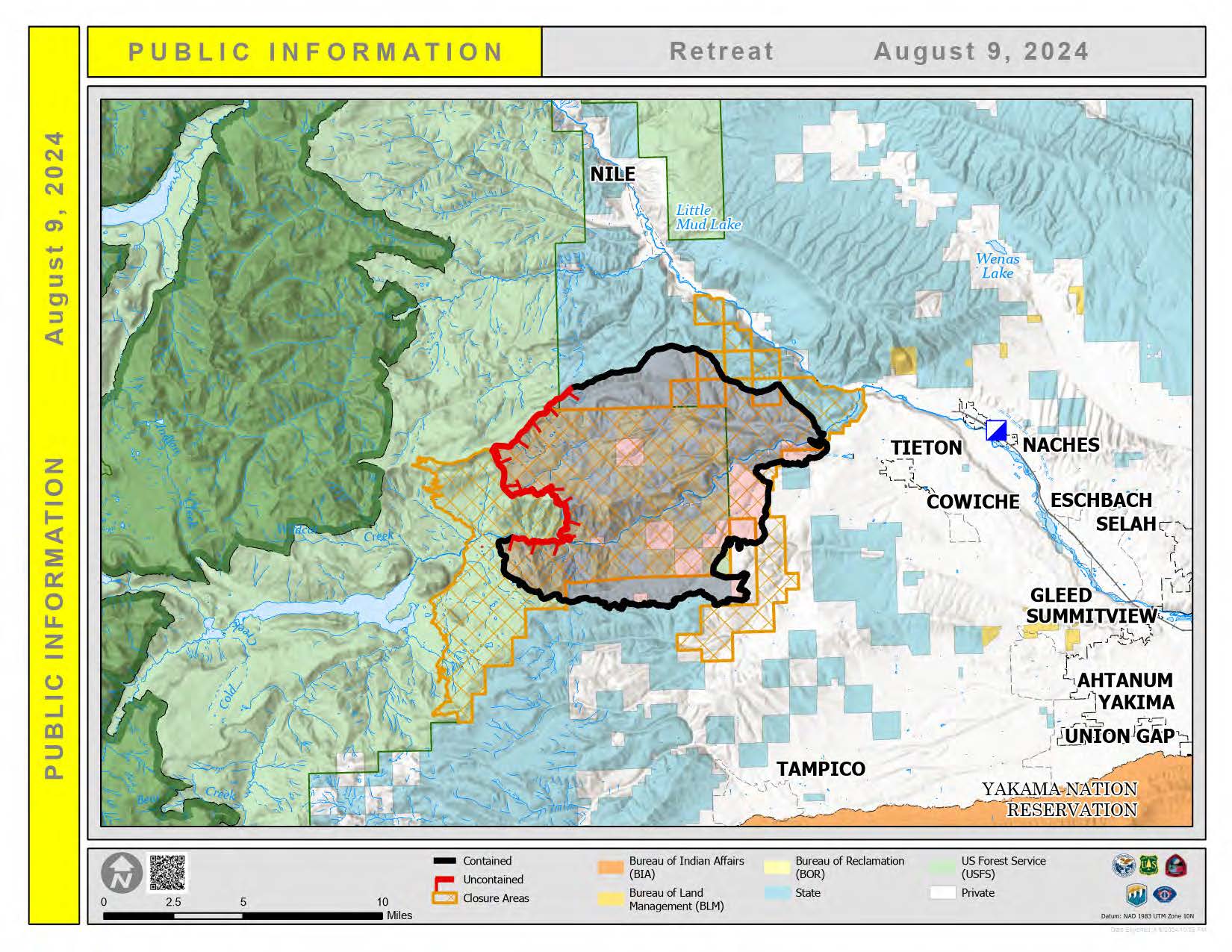
Retreat fire public information map.
Actualizacin Matutina del Incendio en el Retiro 9 de Agosto 08 09 2024
Related Incident: Retreat
Publication Type: News
Retreat Fire
Fire Information: 509-213-4890 Email: 2024.retreat@firenet.gov
inciweb.wildfire.gov/incident-information/wases-retreat
Ubicación: 14 millas al suroeste de Naches, WA
Fecha de inicio: 23 de julio de 2024
Causa: Bajo investigación
Tamaño: 45,588 acres
Contención: 63%
Recursos: 549 Personal en total; 4 Bulldozers; 9 Equipos manuales; 53 Camiones
MENSAJES CLAVE:
El corredor de la autopista 12 permanece cerrado al tránsito público por razones de seguridad pública y de los bomberos. Los árboles grandes debilitados por el fuego siguen representando un riesgo de caer en la carretera en momentos inesperados. Siguen existiendo puntos calientes a lo largo del corredor de la autopista 12, que se espera que permanezca cerrado durante varios días.
ESTADO ACTUAL:
El Equipo 14 de Gestión de Incidentes Complejos de California está gestionando el incendio Retreat bajo una estrategia de supresión total, priorizando la seguridad pública y de los bomberos. Los bomberos están progresando bien con el control del perímetro.
Ayer, el trabajo de limpieza continuó a lo largo de los lados noreste, este y sur del incendio. Los bomberos seguirán patrullando estas áreas para asegurarse de que el calor o el fuego no amenacen la línea. Los equipos también seguirán extinguiendo los puntos calientes donde sea necesario. El calor restante se encuentra principalmente en el lado oeste arbolado del incendio, y los equipos se centran en contener estas áreas. El grupo de equipo pesado continúa construyendo el cortafuegos sombreado a lo largo de un camino interior paralelo a Forest Roads 1200 y 1201. Este cortafuegos sombreado funcionará como una línea de control alternativa. En la esquina suroeste del incendio, los equipos continúan limpiando y patrullando alrededor de las estructuras en Camp Ghormley, Lost Lake Road y a lo largo del corredor de la autopista 12.
CLIMA Y COMPORTAMIENTO DEL INCENDIO:
El viernes, los vientos del noreste al sureste serán algo más fuertes y racheados que a principios de la semana a medida que se acerca un sistema de baja presión. Existe riesgo de tormentas eléctricas hoy, esta noche y todo el día del sábado.
Los combustibles están anormalmente secos en toda el área del incendio. Hoy, el fuego seguirá ardiendo en focos en todo el interior y el humo seguirá siendo visible. Los bomberos buscarán focos de incendio que podrían producirse con los fuertes vientos de hoy.
CIERRES Y EVACUACIONES:
Para obtener la información más actualizada sobre evacuaciones, visite el sitio web de Gestión de Emergencias del Condado de Yakima en este enlace: Sitio web de Gestión de Emergencias de Yakima.
- La US Hwy 12 permanece cerrada entre la Y en la Hwy 410 y la cima del Paso en el poste de la milla 151.
- Cierre del incendio Retreat del Bosque Nacional Okanogan-Wenatchee: www.fs.usda.gov/alerts/okawen/alerts-notices/?aid=89192.
- La Región Sudeste del Departamento de Recursos Naturales del Estado de Washington (DNR) ha cerrado temporalmente el Bosque Estatal Ahtanum debido al aumento de la actividad del incendio Retreat adyacente que arde cerca del lago Rimrock. El público puede acceder a la información de cierre más actualizada en www.dnr.wa.gov/ahtanum.
- El Departamento de Pesca y Vida Silvestre de Washington ha cerrado la mayor parte del Área de Vida Silvestre de Oak Creek al acceso público debido al incendio Retreat hasta el 23 de agosto para garantizar la seguridad pública y facilitar las tareas de extinción del incendio. Puede encontrar más información en Áreas de Vida Silvestre | Departamento de Pesca y Vida Silvestre de Washington.
CALIDAD DEL AIRE Y HUMO:
Las condiciones del aire y del humo y las perspectivas de humo se pueden encontrar en https://www.airnow.gov/

Retreat fire information map is spanish.
Willamette Complex South Daily Update Friday 08 09 2024
Related Incident: Willamette Complex Fires - South
Publication Type: News
Fire Update – Willamette Complex (South)
Chalk, Coffeepot, McKinley, Moss Mountain, Tire Mountain, 208, and 217 Fires
Friday, August 9, 2024 – 9:00 a.m.
Rocky Mountain Complex Incident Management Team 1
Dan Dallas, Incident Commander
Information Phone: (541) 208-1742
Email:2024.mossmountain@firenet.gov
Information Staffing Hours: 8 a.m. to 8 p.m.
Special Note
California CIMT13 assumed management of the Pyramid, Slate, and Ore Fires (Willamette Complex North) yesterday. Alaska CIMT3 will assume management of the remainder of Willamette Complex (South) on Saturday morning as the Rocky Mountain CIMT1 reaches the end of our extended tour of duty.
Current Situation
Slow but steady progress continues on meeting the objective of containing the seven Willamette Complex (South) Fires. Work on the Complex’s two largest fires, Chalk and Coffeepot, has shifted from building containment lines to improving, securing, and patrolling those lines as we work towards the containment goal. Today, the Alaska CIMT3 will be shadowing our suppression operations on the ground to develop a full understanding of the terrain, access, fuels, values at risk, fire behavior, and suppression strategies and tactics. This will prepare them to assume management of the fires without interruption on Saturday morning as the Rocky Mountain CIMT1 reaches the end of our tour and heads home. We are grateful to the local communities and agencies who have encouraged and supported us during our time here.
Chalk Fire
Divisions AA and TT: Yesterday’s work included using the UAS (drone) to fire unburned fuels in a large green interior island on the north side of the fire. The drone has completed its mission and will move to the Coffeepot Fire today. In addition, crews patrolled and secured firelines along the perimeter of the divisions.
Division KK: Crews patrolled and secured firelines around the division.
Coffeepot Fire and Moss Mountain Fire
Divisions PP and RR: Crews focused on improving and patrolling firelines yesterday. Today, the UAS (drone) will be used to clear out unburned fuels inside firelines on the southeastern portion of the fire.
Division SS: Moss Mountain Fire progressed 300 ft. southward to the 2120 Road. Crews located and lined three small spots across the road. Future efforts will be directed at holding the fire north of this road. Tentative plans to build dozer line to connect the 2120 Road to the 490 Road proved to be infeasible yesterday. Crews will still work to hold the fire east of the 490 Road, but supervisors are assessing the 2309 Road as a secondary option if needed.
Division WW: Chipping of fuels along indirect containment lines continued in the western part of the division. Mechanized equipment and hand crews continued prepping the 2300 Road as an indirect line, working to the northwest. This multi-day project, which is being closely coordinated with Resource Advisors, will continue today.
Contingency Group: This group continues working with local resources to identify and construct secondary containment lines to protect high value assets existing south of the Coffeepot and Moss Mountain fires.
208 Fire
The 208 Fire in Diamond Peak Wilderness has shown little growth over the past several days. Fire managers plan to aerially assess the fire when priorities for aircraft allow.
217 Fire, Tire Mountain Fire, and McKinley Fire
The 217, Tire Mountain, and McKinley fires are 100% contained and in patrol status.
Weather and Fire Behavior
Yesterday’s weather remained dry, providing favorable conditions for removing fuels with low intensity firing operations. Today will begin with clear skies and an inversion layer holding smoke near ground level. The source of the smoke is a combination of local fires and the Homestead Complex to the south on the Umpqua National Forest. The inversion will break in early afternoon when direct sunshine will raise temperatures into the 70s and 80s and lower relative humidity to 30-40%. Winds will remain light, shifting from downslope winds to northwest winds in the afternoon. A cooling trend beginning early next week will raise humidity and increase fine fuel moisture levels, resulting in less active fire behavior.
Evacuations
For evacuation information please visit: https://www.LaneCountyOR.gov/2024wildfires
To sign up for evacuation alerts please visit: https://www.LaneAlerts.org
Closures and Fire Restrictions
Area, road, trail, and recreation site closures are in place on the Willamette National Forest in the vicinity of many active fires. Temporary road barricades are in place to restrict traffic across the fire areas.
For specific closure information follow this link:
https://www.fs.usda.gov/detail/willamette/alerts-notices/?cid=fseprd552029
Fire restrictions on the Willamette National Forest may be found at this link: https://www.fs.usda.gov/alerts/willamette/alerts-notices/?aid=81487
Temporary Flight Restrictions (TFR) are in place over the Chalk and Moss Fires.
Wildfires are a no-fly zone for unauthorized aircraft, including drones. If you fly, we can’t. For more information, visit http://knowbeforeyoufly.org.
For More Information:
Phone: (541) 208-1742
Email: 2024.mossmountain@firenet.gov
InciWeb: https://inciweb.wildfire.gov/incident-information/orwif-oakridge-lightning-fires-2024
Facebook: https://www.facebook.com/OakridgeLightningFires2024/
Total Willamette Complex Personnel: 1,078
Fire Cause: Lightning
Location: North & South of Oakridge, OR