
Yakima Valley OEM Reduces Evacuation Levels
Related Incident:
Publication Type: Announcement
Left Hand Fire Level 3 Evacuation zones reduced to Level 2 Left Hand Fire Level 3 Evacuation zones reduced to Level 2.
OkanoganWenatchee National Forest Closure Area
Related Incident:
Publication Type: Closures
Please see the Okanogan-Wenatchee National Forest's Order closing the area affected by the Left Hand Fire:
https://inciweb.nwcg.gov/iwmedia/content//WAOWF/2019-07-24-1600-Left-Hand-Fire/related_files/pict20190631-132835-0.pdf
INFORMACIN SOBRE EL INCENDIO LEFT HAND 7312019
Related Incident:
Publication Type: News
Actividad actual: Ayer la tarde cálida, seca y ventosa contribuyó a un día de fuego más o menos activo ya que hubo árboles que se incendiaron y causó pequeños fuegos. Los bomberos continuaron fortaleciendo las líneas de contención en los extremos oeste y sur del incendio lo que aumentó la contención hasta el 26%. Las cuadrillas están aprovechando los niveles más bajos de combustibles existentes en el área de fuego planeado Canteen de 2016 y el área del incendio Rock Creek de 2016 para ayudar a conectar las líneas de contención en los lados este y noreste del incendio.
Las temperaturas subirán los próximos dos días junto con vientos ligeros. Ya que los vientos han bajado y ha aumentado la humedad, los bomberos están planeando quemar carburantes en el lado norte para unir el cortafuego en el perímetro incontrolado del incendio. Es posible que habrá humo visible como resultado de estas acciones de supresión. Las aeronaves siguen disponibles para apoyar las operaciones en el suelo. El equipo de protección de estructuras continuará patrullando el corredor del camino 410. Las cuadrillas continuarán fortaleciendo las líneas de contención establecidas en los lados oeste, sur y sureste.
Evacuaciones: Se ha emitido un aviso de evacuación de Nivel Tres a 22 residencias en la cuenca de Rock Creek. Los avisos de Nivel Dos siguen vigentes para las 250 residencias a ambos lados del camino SR410 desde la estación del Distrito de Bomberos 14 #11 hasta el cruce con Gold Creek Rd. Parainformación adicional sobre las evacuaciones, visite la página de Facebook del OEM del Condado de Yakima en: www.facebook.com/YakimaCountyOEM.
Cierres: Se han cerrado los caminos Rock Creek Road (FSR 1702) y Bald Mountain Road (FSR 1701) por seguridad al público y para permitir a los bomberos un acceso sin obstáculos a la zona de incendios. El Departamento de Pesca y Vida Silvestre de Washington ha cerrado temporalmente aproximadamente 5,000 acres de la parte suroeste del área de vida silvestre de Oak Creek Wildlife. Para más información sobre la zona de cierre, visite: www.inciweb.nwcg.gov/incident/6456.
Humo: Para obtener información sobre el humo y la salud pública, visite: www.wasmoke.blogspot.com. Para información sobre el humo en español visite:
https://www.doh.wa.gov/CommunityandEnvironment/AirQuality/SmokeFromFires/HumodeIncendios
Información del incendio:
Inciweb: www.inciweb.nwcg.gov/incident/6456
Facebook: www.facebook.com/LeftHandFire
Centro de Información del Incendio: 509-731-3690
Equipo de Gestión de Incidentes: Northwest IMT 7 (Eric Knerr IC)
Left Hand Fire Update 7312019
Related Incident:
Publication Type: News
Current Activity: Yesterday’s warm, dry, and windy afternoon contributed to a fairly active fire day with torching and spotting in timber fuels. Firefighters continued to strengthen containment lines on the west and south edges of the fire, bringing the containment level up to 26%. Crews are taking advantage of the lower levels of existing fuels in the 2016 Canteen prescribed burn area and the 2016 Rock Creek Fire burn area to help connect containment lines on the eastern and northeastern flanks of the fire.
Temperatures will rise the next two days and be accompanied by light winds. With lower winds and increased humidity levels, fire personnel are planning to begin burn out operations on the north flank to tie the fireline into the uncontrolled perimeter of the fire. There may be some visible smoke as a result of these suppression actions. Aircraft resources continue to be available to support ground operations. Structure protection equipment will continue to patrol the Highway 410 corridor. Crews will continue to strengthen the established containment lines on the west, south, and southeast flanks.
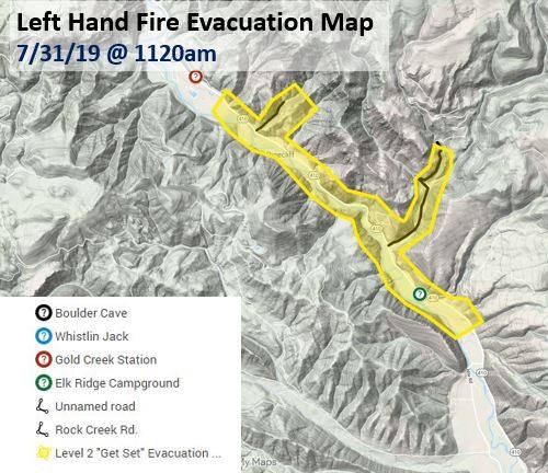
Evacuations: A Level Three evacuation notice has been issued to 22 residences in the Rock Creek drainage. Level Two notices remain in effect for the 250 residences along both sides of SR 410 from the Fire District 14 station #11 to the junction with Gold Creek Rd. For additional information on evacuations please visit the Yakima County OEM Facebook page at: www.facebook.com/YakimaCountyOEM.
Closures: The Rock Creek Road (FSR 1702) and the Bald Mountain Road (FSR 1701) have been closed for public safety and firefighters unimpeded access to the fire area. The Washington Department of Fish and Wildlife has temporarily closed approximately 5,000 acres of the southwest portion of the Oak Creek Wildlife area. For details of the closure area please visit: www.inciweb.nwcg.gov/incident/6456.
Smoke: For information on smoke and public health, please visit: www.wasmoke.blogspot.com. For smoke information in Spanish visit: https://www.doh.wa.gov/CommunityandEnvironment/AirQuality/SmokeFromFires/HumodeIncendios
Fire Information:
Inciweb: www.inciweb.nwcg.gov/incident/6456
Facebook: www.facebook.com/LeftHandFire
Fire Information Center: 509-731-3690
Incident Management Team: Northwest IMT 7 (Eric Knerr IC)
INFORMACIN SOBRE EL INCENDIO LEFT HAND 07302019
Related Incident:
Publication Type: News
Reunión pública: Habrá una reunión comunitaria hoy a las 6:00 pm en la iglesia Nile Community Church, 60 Bedrock Lane, Naches, WA. Los directores del incendio y los cooperantes de agencias estarán disponibles para responder a sus preguntas.
Actividad actual: Ayer, todas las líneas de contención en el perímetro oeste y sur funcionaron bien. Los bomberos aseguraron el cortafuego alrededor del lado sureste a lo largo de Rock Creek Rd hasta el incendio de 2016 en Rock Creek. Las cuadrillas que trabajan en el área de Rock Creek casi completaron la evaluación de estructuras y el trabajo de preparación de hogares y otros valores en riesgo. Ya que tienen más recursos disponibles, las cuadrillas utilizarán sistemas de carreteras y continuarán preparando líneas en los lados norte y este. Siguen disponibles las aeronaves que apoyan a las cuadrillas en el suelo y ayudan a que se controle el fuego. El clima de hoy puede producir ráfagas de viento moderadas a lo largo de las altas crestas junto con mayor actividad de fuego a lo largo del lado noreste.
Evacuaciones: Se ha emitido un aviso de evacuación de Nivel Tres a 22 residencias en la cuenca de Rock Creek. Los avisos de Nivel Dos siguen vigentes para las 250 residencias a ambos lados del camino SR410 desde la estación del Distrito de Bomberos 14 #11 hasta el cruce con Gold Creek Rd. Parainformación adicional sobre las evacuaciones, visite la página de Facebook del OEM del Condado de Yakima en: www.facebook.com/YakimaCountyOEM.
Cierres: Se han cerrado los caminos Rock Creek Road (FSR 1702) y Bald Mountain Road (FSR 1701) por seguridad al público y para permitir a los bomberos un acceso sin obstáculos a la zona de incendios. El Departamento de Pesca y Vida Silvestre de Washington ha cerrado temporalmente aproximadamente 5,000 acres de la parte suroeste del área de vida silvestre de Oak Creek Wildlife. Para más información sobre la zona de cierre, visite: www.inciweb.nwcg.gov/incident/6456.
Humo: Para obtener información sobre el humo y la salud pública, visite: www.wasmoke.blogspot.com. Para información sobre el humo en español visite:
https://www.doh.wa.gov/CommunityandEnvironment/AirQuality/SmokeFromFires/HumodeIncendios
Información del incendio:
Inciweb: www.inciweb.nwcg.gov/incident/6456
Facebook: www.facebook.com/LeftHandFire
Centro de Información del Incendio: 509-731-3690
Equipo de Gestión de Incidentes: Northwest IMT 7 (Eric Knerr IC)
Left Hand Fire Update 07302019
Related Incident:
Publication Type: News
Public Meeting: There will be a community meeting today at 6:00 pm at Nile Community Church, 60 Bedrock Lane, Naches, WA. Fire managers and agency cooperators will be available to answer your questions.
Current Activity: Yesterday, all containment lines on the west and south perimeter held. Firefighters secured the fireline around the southeast flank along Rock Creek Rd up to the 2016 Rock Creek Fire. Crews working in the Rock Creek area largely completed structure assessment and preparation work to homes and other values at risk. With additional resources on hand, crews will utilize road systems and continue prepping line on the north and east flanks. Aircraft resources continue to be available to support crews on the ground and keep the fire in check. Today’s weather may produce moderate wind gusts along high ridges with increased fire activity along the northeastern flank.
Evacuations: A Level Three evacuation notice has been issued to 22 residences in the Rock Creek drainage. Level Two notices remain in effect for the 250 residences along both sides of Sr 410 from the Fire District 14 station #11 to the junction with Gold Creek Rd. For additional information on evacuations please visit the Yakima County OEM Facebook page at: www.facebook.com/YakimaCountyOEM.
Closures: The Rock Creek Road (FSR 1702) and the Bald Mountain Road (FSR 1701) have been closed for public safety and firefighters unimpeded access to the fire area. The Washington Department of Fish and Wildlife has temporarily closed approximately 5,000 acres of the southwest portion of the Oak Creek Wildlife area. For details of the closure area please visit: www.inciweb.nwcg.gov/incident/6456.
Smoke: For information on smoke and public health, please visit: www.wasmoke.blogspot.com. For smoke information in Spanish visit: https://www.doh.wa.gov/CommunityandEnvironment/AirQuality/SmokeFromFires/HumodeIncendios
Fire Information:
Inciweb: www.inciweb.nwcg.gov/incident/6456
Facebook: www.facebook.com/LeftHandFire
Fire Information Center: 509-731-3690
Incident Management Team: Northwest IMT 7 (Eric Knerr IC)
INFORMACIN SOBRE EL INCENDIO LEFT HAND 07292019
Related Incident:
Publication Type: News
Actividad actual: Ayer los bomberos construyeron y reforzaron las líneas de contención en la cresta sobre el camino SR410 y en el extremo sur. Además. giraron una esquina hacia el norte a lo largo de la Rock Creek Rd. Las aeronaves echaron agua y mantuvieron los fuegos pequeños bajo control y minimizaron la propagación en otras laderas. Las cuadrillas de apoyo continúan progresando al proteger los hogares en el área de Rock Creek mediante la instalación de sistemas de mangueras, aspersores y al cortar maleza. Un grupo de protección de estructuras seguirá trabajando dentro de las áreas de evacuación para crear un espacio defendible y otra protección. Los objetivos con la prioridad más alta siguen siendo los de proteger las estructuras, las comunidades y otras cosas de valor bajo riesgo a lo largo del camino 410. Hoy, las cuadrillas continuarán construyendo, conteniendo, y fortaleciendo tanto las líneas directas e indirectas alrededor del perímetro del incendio y construyendo líneas de contingencia según sea necesario.
Evacuaciones: Se ha emitido un aviso de evacuación de Nivel Tres a 22 residencias en la cuenca de Rock Creek. Los avisos de Nivel Dos siguen vigentes para las 250 residencias a ambos lados del camino SR410 desde la estación del Distrito de Bomberos 14 #11 hasta el cruce con Gold Creek Rd. Para obtener información adicional sobre las evacuaciones, visite la página de Facebook del OEM del Condado de Yakima en: www.facebook.com/YakimaCountyOEM.
Cierres: Se han cerrado los caminos Rock Creek Road (FSR 1702) y Bald Mountain Road (FSR 1701) para permitir a los bomberos un acceso sin obstáculos a la zona de incendios. El Departamento de Pesca y Vida Silvestre de Washington ha cerrado temporalmente aproximadamente 5,000 acres de la parte suroeste del área de vida silvestre de Oak Creek Wildlife. Para obtener más información sobre la zona de cierre, visite: www.inciweb.nwcg.gov/incident/6456.
Humo: Para obtener información sobre el humo y la salud pública, visite: www.wasmoke.blogspot.com.Para información sobre humo en español visite:
https://www.doh.wa.gov/CommunityandEnvironment/AirQuality/SmokeFromFires/HumodeIncendios
Información del incendio:
Inciweb: www.inciweb.nwcg.gov/incident/6456
Facebook: www.facebook.com/LeftHandFire
Centro de Información del Incendio: NEW NUMBER 509-731-3690
Equipo de Gestión de Incidentes: Northwest IMT 7 (Eric Knerr IC)
Fin
Community Meeting July 30 6pm Nile Community Church
Related Incident:
Publication Type: Announcement
There will be a community meeting tomorrow, July 30th, at Nile Community Church. The meeting will begin at 6pm. The Incident Commander, Operations, Washington Department of Natural Resources, Washing Department of Fish and Wildlife, Yakima County representatives, and other distinguished guests will be available to answer your questions.
Nile Community Church is located at 60 Bedrock Lane along Hwy 410.
Left Hand Fire Update 07292019
Related Incident:
Publication Type: News
Current Activity: Yesterday firefighters constructed and strengthened containment lines on the ridge above SR410 and on the south flank and turning a corner to the north along the Rock Creek Rd. Aircraft using water drops, held spot fires in check and minimized the rate of spread on other flanks. Structure support crews continue making good progress protecting homes in the Rock Creek area by installing hose lays, sprinklers, and cutting brush. A structure protection group will continue to work within the evacuation areas to create defensible space and other protection. The highest priority objectives continue to be protecting structures, communities, and other values at risk along the 410 corridor. Today, crews will continue to construct, hold, and strengthen both direct and indirect lines around the perimeter of the fire and construct contingency lines as needed.
Evacuations: A Level Three evacuation notice has been issued to 22 residences in the Rock Creek drainage. Level Two notices remain in effect for the 250 residences along both sides of Sr 410 from the Fire District 14 station #11 to the junction with Gold Creek Rd. For additional information on evacuations please visit the Yakima County OEM Facebook page at: www.facebook.com/YakimaCountyOEM.
Closures: The Rock Creek Road (FSR 1702) and the Bald Mountain Road (FSR 1701) have been closed to allow firefighters unimpeded access to the fire area. The Washington Department of Fish and Wildlife has temporarily closed approximately 5,000 acres of the southwest portion of the Oak Creek Wildlife area. For details of the closure area please visit: www.inciweb.nwcg.gov/incident/6456.
Smoke: For information on smoke and public health, please visit: www.wasmoke.blogspot.com. For smoke information in Spanish visit: https://www.doh.wa.gov/CommunityandEnvironment/AirQuality/SmokeFromFires/HumodeIncendios
Fire Information:
Inciweb: www.inciweb.nwcg.gov/incident/6456
Facebook: www.facebook.com/LeftHandFire
Fire Information Center: NEW NUMBER 509-731-3690
Incident Management Team: Northwest IMT 7 (Eric Knerr IC)
Left Hand Fire Update 07282019
Related Incident:
Publication Type: News
Current Activity: Yesterday saw the Left Hand Fire more than double in size, with growth on the south and east flanks of the fire. Strong winds continued to drive active fire behavior into the night. Firefighters had success in establishing containment lines on the west flank to keep it on the ridge above the Highway 410 corridor. Lighter winds forecast for today should moderate fire behavior. Crews, with aircraft support, will continue to build both direct and indirect fireline today in efforts to hold the fire on the ridge on the western flank and provide opportunities to check its advance on the remaining perimeter. A structure protection group will continue to do assessments and provide protection to threatened structures.
Evacuations: A Level Three evacuation notice has been issued to 22 residences in the Rock Creek drainage. Level Two notices remain in effect for the 250 residences along both sides of Sr 410 from the Fire District 14 station to Cliffdell. For additional information on evacuations please visit the Yakima County OEM Facebook page at: www.facebook.com/YakimaCountyOEM.
Closures: The Rock Creek Road (FSR 1702) and the Bald Mountain Road (FSR 1701) have been closed to allow firefighters unimpeded access to the fire area. The Washington Department of Fish and Wildlife has temporarily closed approximately 5,000 acres of the southwest portion of the Oak Creek Wildlife area. For details of the closure area please visit: www.inciweb.nwcg.gov/incident/6456.
Smoke: For information on smoke and public health, please visit: www.wasmoke.blogspot.com. For smoke information in Spanish visit: https://www.doh.wa.gov/CommunityandEnvironment/AirQuality/SmokeFromFires/HumodeIncendios
Fire Information:
Inciweb: www.inciweb.nwcg.gov/incident/6456
Facebook: www.facebook.com/LeftHandFire
Fire Information Center: NEW NUMBER 509-731-3690
Incident Management Team: Northwest IMT 7 (Eric Knerr IC)