
Air Quality Report 81419
Related Incident:
Publication Type: News
Fire
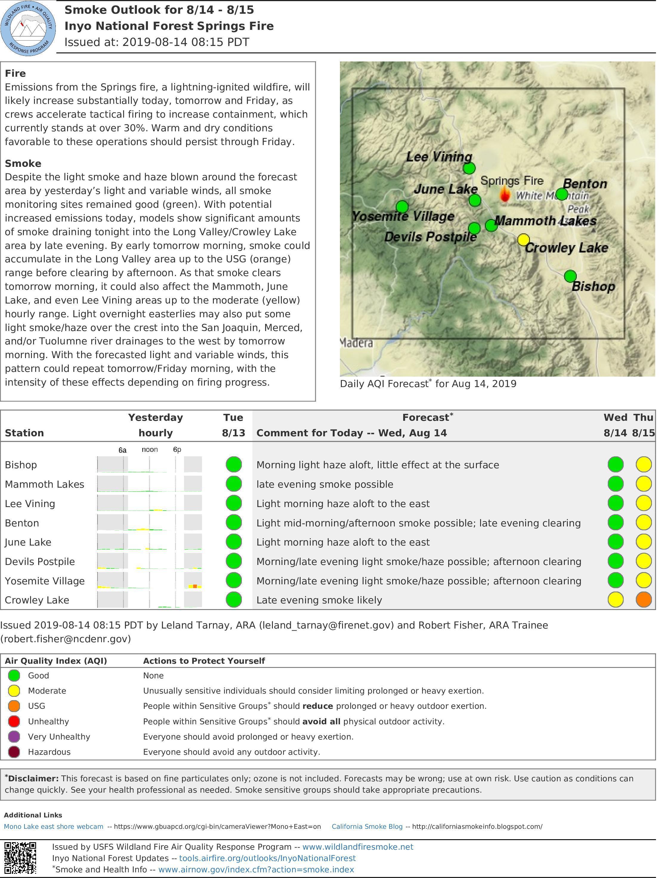
Emissions from the Springs fire, a lightning-ignited wildfire, will likely increase substantially today, tomorrow and Friday, as crews accelerate tactical firing to increase containment, which currently stands at over 30%. Warm and dry conditions favorable to these operations should persist through Friday.
Smoke
Despite the light smoke and haze blown around the forecast area by yesterday’s light and variable winds, all smoke monitoring sites remained good (green). With potential increased emissions today, models show significant amounts of smoke draining tonight into the Long Valley/Crowley Lake area by late evening. By early tomorrow morning, smoke could accumulate in the Long Valley area up to the USG (orange) range before clearing by afternoon. As that smoke clears tomorrow morning, it could also affect the Mammoth, June Lake, and even Lee Vining areas up to the moderate (yellow) hourly range. Light overnight easterlies may also put some light smoke/haze over the crest into the San Joaquin, Merced, and/or Tuolumne river drainages to the west by tomorrow morning. With the forecasted light and variable winds, this pattern could repeat tomorrow/Friday morning, with the intensity of these effects depending on firing progress.
Springs TFR Information
Related Incident:
Publication Type: Closures
![]()
![]()
![]()
![]()
![]()


 >
> 
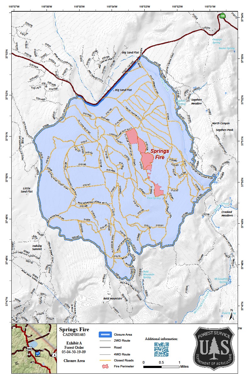
 NOTAM Number : FDC 9/7847 Download shapefiles Issue Date : August 11, 2019 at 2330 UTC Location : MONO COUNTY, California near BISHOP VOR/DME (BIH) Beginning Date and Time : August 12, 2019 at 1300 UTC Ending Date and Time : November 12, 2019 at 1300 UTC Reason for NOTAM : TO PROVIDE A SAFE ENVIRONMENT FOR FIRE FIGHTING Type : Hazards Replaced NOTAM(s) : N/A Jump To:
  >
>
 >
> >// > >// >
 >
> PDF Report of Notam >Operating Restrictions and Requirements Top No pilots may operate an aircraft in the areas covered by this NOTAM (except as described).
Other Information: Top ARTCC: ZOA - Oakland Center Point of Contact: INYO NATIONAL FOREST Telephone 760-873-2488 Frequency 120.775 Authority: Title 14 CFR section 91.137(a)(2) ![]()
![]()
![]() Depicted TFR data may not be a complete listing. Pilots should not use the information on this website for flight planning purposes. For the latest information, call your local Flight Service Station at 1-800-WX-BRIEF.
Depicted TFR data may not be a complete listing. Pilots should not use the information on this website for flight planning purposes. For the latest information, call your local Flight Service Station at 1-800-WX-BRIEF. ![]() U.S. Department of Transportation
U.S. Department of Transportation
Federal Aviation Administration
800 Independence Avenue, SW
Washington, DC 20591
1-866-TELL-FAA (1-866-835-5322)
Readers & Viewers


Web Policies
Government Sites
Contact Us
- Customer Support: 1-866-466-1336
>Customer Support:
1-866-466-1336 - Email: 7-AWA-NAIMES@faa.gov
>Email: 7-AWA-NAIMES@faa.gov
Air Quality Report 81019
Related Incident:
Publication Type: News
Fire
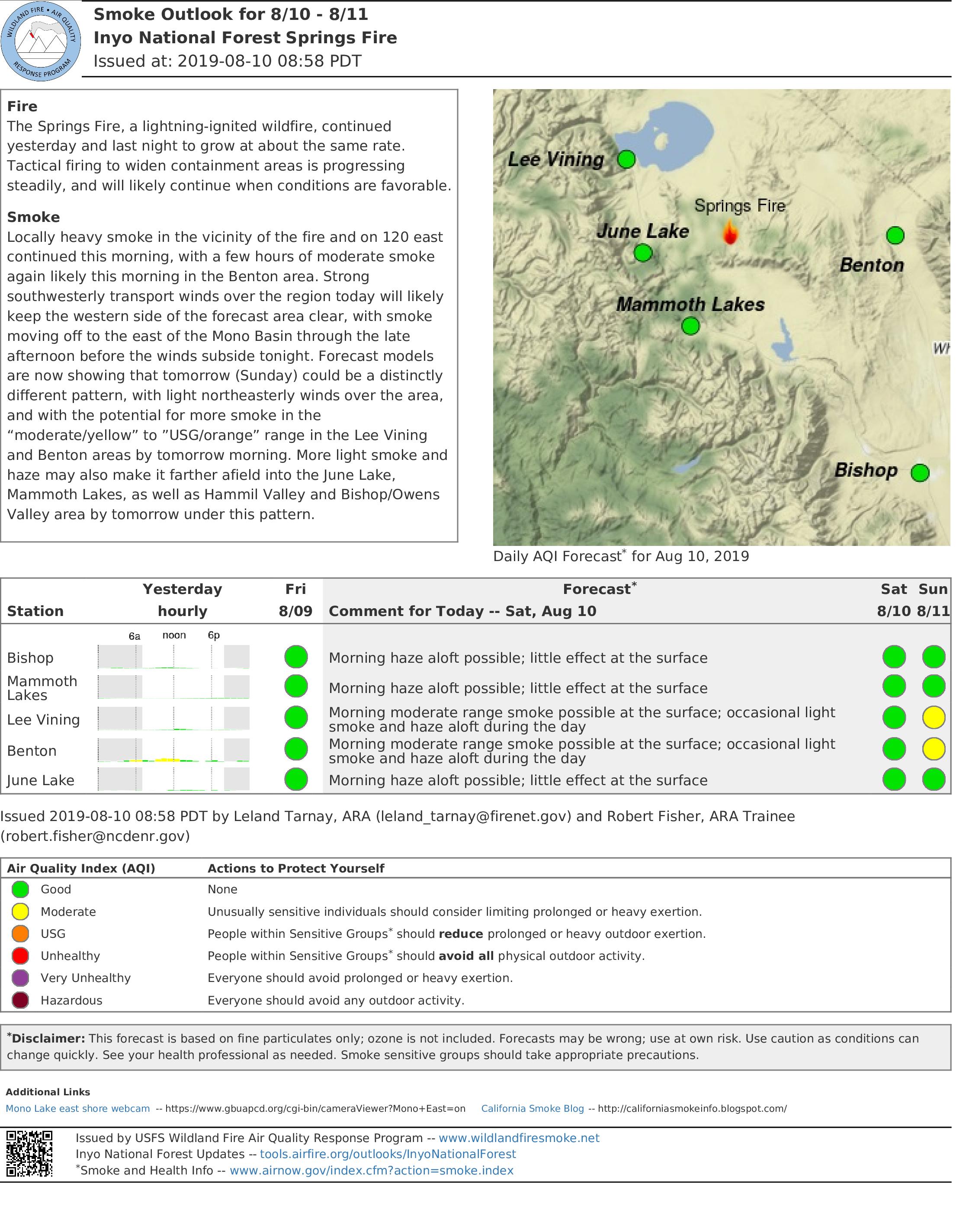
The Springs Fire, a lightning-ignited wildfire, continued yesterday and last night to grow at about the same rate. Tactical firing to widen containment areas is progressing steadily, and will likely continue when conditions are favorable.
Smoke
Locally heavy smoke in the vicinity of the fire and on 120 east continued this morning, with a few hours of moderate smoke again likely this morning in the Benton area. Strong southwesterly transport winds over the region today will likely keep the western side of the forecast area clear, with smoke moving off to the east of the Mono Basin through the late afternoon before the winds subside tonight. Forecast models are now showing that tomorrow (Sunday) could be a distinctly different pattern, with light northeasterly winds over the area, and with the potential for more smoke in the “moderate/yellow” to ”USG/orange” range in the Lee Vining and Benton areas by tomorrow morning. More light smoke and haze may also make it farther afield into the June Lake, Mammoth Lakes, as well as Hammil Valley and Bishop/Owens Valley area by tomorrow under this pattern.
Air Quality Report 8819
Related Incident:
Publication Type: News
Fire
The Springs Fire, a lightning-ignited wildfire, grew last night approximately 90 more acres in lighter fuels, under continued favorable tactical firing conditions, and is now at approximately 330 acres as of this morning. Lighter fuels ahead of the fire will likely result in less daily smoke emissions over the next few days, even if daily acreages increase. Most firing today will occur in the evening, after the potential for thunderstorms passes. The pattern of slow growth and tactical firing in the evening is will likely continue today and tomorrow.
Smoke
Locally heavy smoke in the vicinity of the fire was again evident this morning over highway 120 east near the fire, with a distinct haze layer also visible over the eastern end of the Mono Basin. Reduced smoke emissions, stronger southwesterly transport winds over the fire area, along with the potential for wetter thunderstorms will likely reduce these impacts today and tomorrow. This improved dispersion will also likely mean less morning smoke/haze aloft over down the Hammil and Owens Valley in the late evening/early morning. All monitors in the forecast area are expected to remain in good range today and tomorrow
Air Quality Report 8919
Related Incident:
Publication Type: News
Fire
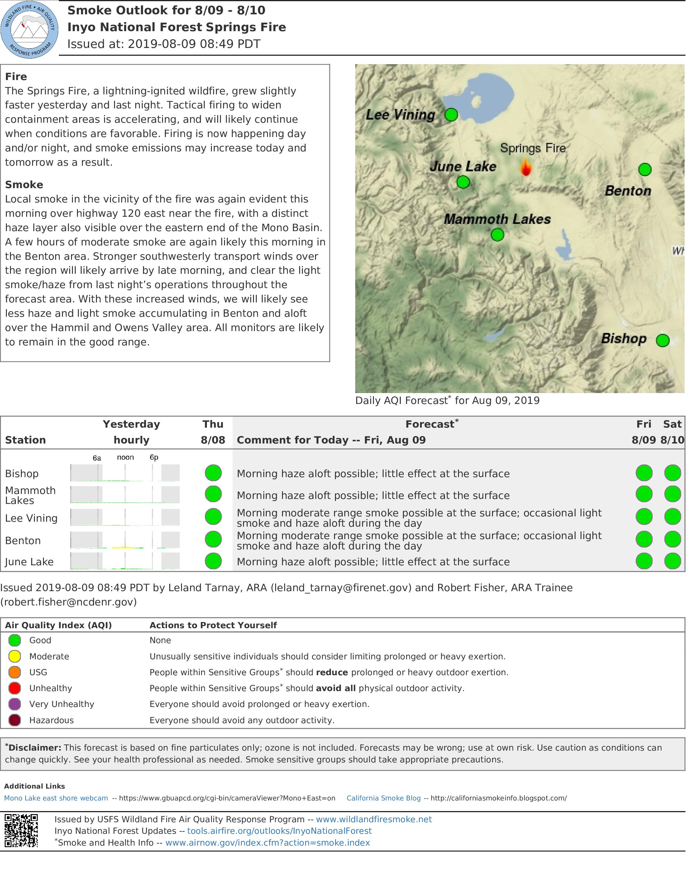
The Springs Fire, a lightning-ignited wildfire, grew slightly
faster yesterday and last night. Tactical firing to widen
containment areas is accelerating, and will likely continue
when conditions are favorable. Firing is now happening day
and/or night, and smoke emissions may increase today and
tomorrow as a result.
Smoke
Local smoke in the vicinity of the fire was again evident this
morning over highway 120 east near the fire, with a distinct
haze layer also visible over the eastern end of the Mono Basin.
A few hours of moderate smoke are again likely this morning in
the Benton area. Stronger southwesterly transport winds over
the region will likely arrive by late morning, and clear the light
smoke/haze from last night’s operations throughout the
forecast area. With these increased winds, we will likely see
less haze and light smoke accumulating in Benton and aloft
over the Hammil and Owens Valley area. All monitors are likely
to remain in the good range.
Air Quality Summary Saturday August 3 2019
Related Incident:
Publication Type: Announcement
Smoke forecastTwo fires are actively burning on the Nez Perc-Clearwater National Forest and continue to impact neighboring communities. Fire activity has decreased today due to fires receiving precipitation yesterday and last night, but drying will continue through the weekend with increased consumption on fires. Predominate west -south west winds will move more smoke into the Missoula Valley, Bitterroot Valley areas, and other areas to the east and north.The Barren Hill and Crab fire continues to produce smoke and haze impacting Powell, Id and Hamilton, Mt.
See the full forecast by clicking on the link.
Final Update Unless Significant New Activity Occurs
Related Incident:
Publication Type: News
The Phoenix National Incident Management Organization (NIMO) Team that has been working on the Devore Creek Fire for the past thirteen days will transfer command to a local, Type 3 organization tomorrow morning. The NIMO team leaves behind a detailed plan of actions that can be used if the fire comes back to life in a way that threatens people or property. The fire is expected to burn until sustained rain or snow arrives in the fall. Until then, local fire personnel will use two remote cameras to actively keep an eye on the Devore Creek Fire and take action as needed. Two National Park Service personnel are stationed in the Stehekin Valley and are ready to help coordinate additional actions if necessary.
The National Park Service has reopened the portion of the Stehekin River Trail that was closed during the past two weeks. There are hoses deployed along the trail that would be used if the fire should advance close to the Stehekin Valley. We ask the public to leave all firefighting equipment where they find it. Three other trails that lead into the fire area remain closed for the safety of the public.
Beginning tomorrow morning, the phone number now associated with the fire will no longer be in use but people with questions can call the Chelan Ranger District at (508)-682-4900, Mon-Fri from 7:45am to 4:30pm. The incident Inciweb and Facebook pages will be updated if there are new developments.
-End-
More Rain Possible Today on Fire
Related Incident:
Publication Type: News
August 10, 2019 – 9:00 a.m.
Acres: 450
Location: 3 air miles southwest of Stehekin, WA
Completion: Season-ending weather event
Cause: Lightning
Estimated Cost: $1,058,000
Report Date: July 26, 2019 (ignited by the lightning storms that came through on July 23 and 24)
Personnel: 58, including 1 hand crew, 2 helicopters, 31 overhead personnel
Current Activity: At least a tenth of inch of rain has fallen on the Devore Creek Fire area since midnight and more scattered showers are possible throughout the day today. No rain fell on the fire Friday but fire growth was moderated by cooler temperatures and higher humidity. Higher humidity levels and cooler temperatures are forecast through next week.
A community meeting will be held in Stehekin tomorrow at 5:30 p.m. at the (new) Stehekin School. Staff from the Forest Service, National Park Service, Washington Department of Natural Resources, the Chelan County Office of Emergency Management, and the Incident Management Team will provide a brief overview of long term plans for the fire and will be available to answer questions.
Work on a community protection line near Stehekin, as well as mitigation around US Forest Service and National Park facilities, have been completed. Most firefighters will be leaving Stehekin today but remain prepared to protect the area if the fire becomes active again. Fire personnel will actively observe the fire each day through two remote cameras. Two National Park Service personnel are currently stationed in the Stehekin Valley and are ready to help coordinate additional actions if necessary. No further infrared flights over the fire are planned at this time.
Evacuations: None. (Stehekin is on Level 1 advisement status.) Visit Chelan County Emergency Management on Facebook for additional information. https://www.facebook.com/CCSOEM/
Closures: On the Okanogan-Wenatchee National Forest, Devore Creek Trail #1244, Company Creek Trail #1243, and Ten Mile Creek Trail #1241 are currently closed for public safety. Company Creek Trail is closed at the trailhead in Lake Chelan National Recreation Area. The Stehekin River Trail in Lake Chelan National Recreation Area is closed temporarily between Weaver Point and the Stehekin airstrip.
Smoke Information: Air quality monitoring stations are located throughout the area, including Chelan, Twisp, Winthrop and (temporarily). For current data on smoke in this area visit: http://bit.ly/2GZnv8V For more information on smoke and your health visit wasmoke.blogspot.com or en Espanol tinyurl.com/yanjrv7m.
Other: All Chelan and Stehekin area businesses are open, please consider supporting local tourism.
Devore Creek Fire Information: 602-726-5482
Inciweb: inciweb.nwcg.gov/incident/6463
Facebook: @DevoreCreekFire
Text Message: follow okawennf to 40404 (iphone)
Twitter: @OkaWenNF
#DevoreCreekFire #WaWildfire #FireForest
-End-
Devore Creek Fire Community Meeting August 11 2019 at 530 pm
Related Incident:
Publication Type: Announcement
Devore Fire Community Meeting
August 11, 2019 at 5:30 pm New Stehekin School
Staff from the Forest Service, National Park Service, Washington Department of Natural Resources, the Chelan County Office of Emergency Management, and the Incident Management Team will provide a brief overview of current operations, the long term strategy for the fire, and will be available to answer questions.