
Fremont County Sheriff Preevacuation Update
Related Incident:
Publication Type: Announcement
Fremont County Sheriff Pre-evacuation Update
Effective October 7th at 3:00 PM, the pre-evacuation notice for the communities of Wellsville and Swissvale were lifted.
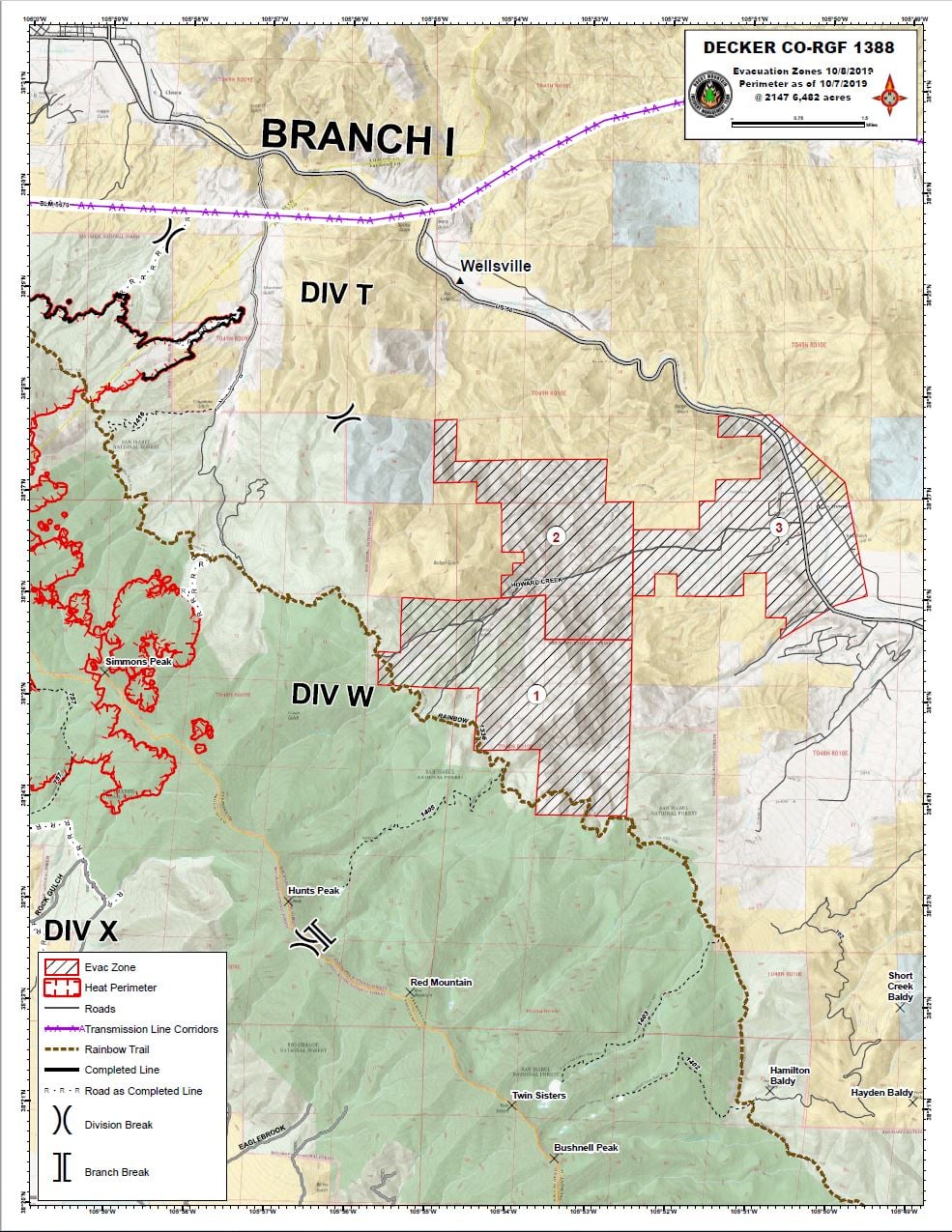
Based on aerial reconnaissance, changing weather conditions and progress made on containment, the communities of Pine Ridge and Howard have been broken out into three Zones. Pine Ridge has been designated as Zone 1 and is the community most at risk. Pine Ridge will remain on pre-evacuation status.
The community of Howard has been broken into Zones 2 and 3 with the dividing line being approximately 105 degrees, 52 minutes and 5 seconds west longitude. Areas west of this line will remain in pre-evacuation status. Pre-evacuation status has been lifted for the area east of this line.
All un-incorporated Fremont County is now under stage 2 fire restrictions, effective at 10:00AM today.
Chaffee County Evacuation Order Cancellation Press Release
Related Incident:
Publication Type: Announcement
Decker Fire Evacuation Update
CHAFFEE COUNTY SHERIFF’S OFFICE
Salida, Colorado
PRESS RELEASE
October 8, 2019
Effective Wednesday, October 9th at 10am, Chaffee County Sheriff John Spezze is cancelling the evacuation order for the residents of the Methodist Estates and Boot Hill Subdivisions and all other residents who access their homes via CR 108 as well as the Chaffee County residents who reside on CR 101, Bear Creek.
Residents of Methodist Estates and Boot Hill will be asked to check in with sheriff personnel starting at 10am, on Wednesday, and will be required to show valid id or rapid tag id issued as part of the Decker Fire Incident to access their homes.
The Chaffee County Sheriff’s Office checkpoint will remain at CR 108, at its current location, as only residents of Methodist Estates and Boot Hill, as well as service providers, will be allowed into the area. No other access will be granted into this area as there are still fire personnel, fire activity and dangerous conditions in the area. All residents will be required to check in upon re-entry each time they return home for safety and accountability reasons. This checkpoint will remain in place for the foreseeable future.
Residents on CR 101 will be allowed directly to their homes on Wednesday as Fremont County will be moving that checkpoint to the Chaffee/ Fremont County line.
All affected residences will remain on Pre-Evacuation Alert
What to Expect When You Return Home
Expect to see certain changes in your neighborhood. You may see firefighters still working in the area; you are also likely to see firefighting and structure protection equipment in the area, including fire engines, pumps hoses, sprinklers, portable tanks, and other items. Firefighting personnel will be removing this equipment from the area s it becomes unneeded, but this process may take a few days. Use extreme caution on roadways, as fire equipment is still operating in the area, and wind-driven ash and dust may make visibility difficult.
Recently burned areas are very dangerous. Fire burns deeply in extremely dry duff layers and weakens trees that may fall unexpectedly. For your safety, please stay out of burned areas, as hot spots and ash pits may still exist. Ash pits are deep holes in the ground filled with hot ash and embers and are often hard to see. Smoldering stumps, an occasional torching tree, or burning underbrush may still be seen within the existing fire perimeter.
Residents allowed to return to their homes remain on pre-evacuation status at this time. Be ready to leave at a moment’s notice. Know how to receive and stay aware of the latest news and information on the fire from local media and community resources.
When you return home:
• Be alert for downed power lines and other hazards.
• Check propane tanks, regulators, and lines before turning gas on.
• Check your residence carefully for hidden embers or smoldering fires.
Thank You
Sheriff John Spezze
Decker Fire Update 10819
Related Incident:
Publication Type: News
October 8, 2019 (10 a.m.)
Special notes: The Decker fire has gained some containment on the north side; it is now 14% contained.
Residents and anyone driving on roads north of the fire are asked to please remain extra aware, extra cautious, and drive slowly to help keep our firefighters safe. There is still a lot of fire traffic, fire equipment, and personnel in this area, and work is still taking place. Thank you!
Weather: Wind gusts were stronger than predicted yesterday and should return today, with gusts up to 40 mph on the ridges. Winds should be from the S/SW, changing to the W/NW around 4pm. Strong winds, an unstable atmospheric environment, and dry conditions once again combine to create a RED FLAG WARNING. Under these conditions, the potential for active fire behavior remains. Today should be mostly sunny with a few clouds, RHs of 14-21%, temperatures 57-64F. Similar conditions return tomorrow (Wednesday), and another RED FLAG WARNING will be in place. On Thursday, a cold front moves into the area, possibly bringing rain, snow, and a hard freeze.
Current Situation: Yesterday in Division R, two fire crews made considerable progress on improving the dozer line leading from the ridgeline at the Division R/A break north to the Rainbow Trial. They also completed improvements on the Rainbow Trail running from the dozer line east to the fire’s edge. In both Divisions R and T, firefighters made substantial progress on the direct handline that wraps around the top and “arm” of the fire. A large section of this is now considered contained and will show as black line on the map. Crews in Division T also worked on the handline that starts at the tip of the “arm” and moves south along CR 101/49. Work along this road is nearly complete. Dozers in Division T kept building the dozer line running from the end of CR 101/49 southeast toward the Rainbow Trail. Handcrews worked on this fireline from the opposite direction, coming from the Howard area and working west. In Division X, crews kept working on indirect line utilizing existing trails and roads. Dozers in Division A built fireline along a ridgeline toward the repeater on Methodist Mountain.
Today, firefighters in Division R will work to secure the remaining direct line on the north side (the part that is still red on maps). Crews in Division T will do the same on the bottom of the “arm,” and will continue to “mop-up” along the already contained areas. (Mopping-up is when crews work along existing fireline, conducting tasks such as extinguishing smoldering material along the fire's edge, ensuring logs/debris cannot roll across the fire line, clearing both sides of the fire line of snags, rotten logs, stumps, singed brush and low hanging limbs of trees, and searching for underground burning roots near the line.) Chipping operations may begin today along CR 101/49, and continue in the coming days. In Division W, crews will improve both hand and dozer line that runs between Howard and the fire. Dozers will work in Division X to continue improving BLM roads, and crews will improve handline that has been constructed closer to the fire’s edge. In Division A on the west, crews will keep building dozer line along the ridge leading to the repeater on Methodist. Structure protection crews remain present in the communities near Howard; pre-evacuations were lifted yesterday for some areas, and officials are assessing timing for others.
Firing operations (aerial, hand, or both) may take place today or in the coming days. These operations are very condition-dependent; fire managers must constantly and carefully evaluate many factors to decide whether these operations are likely to present a high probability of success. Residents may see increased smoke if these operations occur.
Closures and Public Safety: There are multiple road closures around the Decker Fire area in Chaffee, Fremont and Saguache County. For your safety and firefighter safety, please respect posted closures. For San Isabel Forest closures: https://tinyurl.com/SanIsabelClosures. For Rio Grande Forest closures: https://tinyurl.com/RioGrandeClosures. For BLM closures: Facebook @BLMColoradFire and https://tinyurl.com/BLMCLosure. For evacuation information, please contact the Chaffee County Sherriff’s Office: 719-539-2596, or Fremont County Emergency Management: 719-276-7416, 719-276-7418 or go to the Chaffee County Sheriff or Fremont County Sheriff Facebook pages and websites.
Fire Statistics:
Location: Fire started 9 miles south of, and is now burning 2 miles south of Salida, CO Start Date: September 8, 2019
Size: 6,482 acres Percent Contained: 14
Total Personnel: 896 Cause: Lightning
Resources Include: 10 Type-1 hand crews, 15 Type-2 hand crews, 29 engines, 3 dozers, 10 water tenders
Air Resources: 3 Type-1 (K-MAX, Blackhawk, Chinook), 1 Type-2, and 2 Type 3, and 2 fixed-wing aircraft820 PM Update
Related Incident:
Publication Type: Announcement
Containment of the fire is at 14% as of this evening.
This afternoon, pre-evacuation notices were lifted for the communities of Wellsville and Swissvale. Pre-evacuation notices are still in effect for the town of Howard. At this point, the only residents under evacuation are those in Chaffee County with property south of the junction of County Roads 107 and 108 (Boot Hill subdivisions), and all properties on Bear Creek Road.
A Red Flag warning will be in effect Tuesday and Wednesday, with colder weather and possible snow in the forecast for late in the week.
1230 PM Update
Related Incident:
Publication Type: Announcement
Fire activity has increased somewhat in Division A on the west and high up in Division T on the east. Helicopters are dropping water on these areas to cool them and help check fire spread. There is increased smoke.
Decker Fire Update 10719
Related Incident:
Publication Type: News
Special notes: Yesterday, re-entry took place for some formerly evacuated residents north of the fire in Division R. There is still a lot of fire traffic, fire equipment, and personnel in this area, and work is still taking place. Residents and anyone driving on roads north of the fire are asked to please remain extra aware, extra cautious, and drive slowly to help keep our firefighters safe. Thank you!
Residents could see increased smoke over the fire today. Pockets of unburned fuel are still burning within the fire perimeter, and the spots on the west and east are giving off some smoke. Today’s unstable conditions lend themselves to smoke plume development.
Weather: Today should be sunny with low RHs of 7-12%, winds out of the west but largely terrain-driven, gusts up to 20 mph.
A very dry airmass has settled over the fire area and is becoming increasingly unstable as it continues to dry and warm. Light, terrain-driven winds and above normal temperatures (57 to 62F), combined with the unstable airmass, will make for higher chances of large smoke plumes this afternoon between 12pm and 8pm. Such plumes can carry embers and have the potential for long-range spotting.
Looking ahead, cold air should arrive to the fire area overnight Wednesday, with overnight lows in the 20s expected for a few days.
Current Situation: Yesterday in Division R, crews improved the direct handline along the north perimeter of the fire. Bulldozers constructed fireline from north of the Rainbow Trail, south along the ridgeline, to the Chaffee County line at the Division R/A break. In Division T, firefighters built a new section of handline from the tip of the “arm” south, to wrap around some of the houses in Bear Creek. From there, they began working on fireline from the end of Bear Creek and running southeast to join up with the Rainbow Trail. Firefighters in Division T also worked on improving their section of the Rainbow Trail. Crews in Division W used bulldozers to create line that runs east/west between the Wilderness boundary and the community of Howard. In Division X, crews kept scouting for options to improve existing roads and trails. Firefighters in Division A improved the dozer line running south from the Division A/R break. Aircraft were able to fly and do water drops for the entire day yesterday.
Today is an unstable weather day, and firefighters will be on constant lookout for sudden changes in fire behavior. In Division R to the north, firefighters will keep improving indirect and direct fireline, and they will work on clearing debris from CR 108. Bulldozers have spent two days working the line from the Rainbow Trail south to the division break. Today, helicopters will fly a crew of firefighters and equipment onto the ridgeline. This crew will use hand tools to improve the dozer line; working back north toward the Rainbow Trail. In Division T, firefighters will improve a section of the Rainbow Trial and keep working the direct line along the “arm” of the fire, looking for and cooling hotspots. In Divisions W, bulldozers will be building dozer line east/west between the Rainbow Trail and Howard. Crews in this division will keep scouting for locations to construct indirect fireline between the fire and the community of Howard. Crews in Division X will continue dozer work on BLM roads. In Division A, firefighters will work on the dozer line running south from the Division A/R break. The structure protection crews will remain present in Howard.
Fire managers will evaluate opportunities for aerial ignitions. There are several factors and conditions that must align for this operation to create a good probability of success; fire managers will be assessing these throughout the day.
Firefighters on the night operational period remain with the Decker Fire overnight. They are monitoring for changes from the east and west of the fire.
Closures and Public Safety: There are multiple road closures around the Decker Fire area in Chaffee, Fremont and Saguache County. For your safety and firefighter safety, please respect posted closures. For San Isabel Forest closures: https://tinyurl.com/SanIsabelClosures. For Rio Grande Forest closures: https://tinyurl.com/RioGrandeClosures. For BLM closures: Facebook @BLMColoradFire and https://tinyurl.com/BLMCLosure. For evacuation information, please contact the Chaffee County Sherriff’s Office: 719-539-2596, or Fremont County Emergency Management: 719-276-7416, 719-276-7418 or go to the Chaffee County Sheriff or Fremont County Sheriff Facebook pages and websites.
Fire Statistics:
Location: Fire started 9 miles south of, and is now burning 2 miles south of Salida, CO Start Date: September 8, 2019
Size: 6,326 acres Percent Contained: 5
Total Personnel: 882 Cause: Lightning
Resources Include: 10 Type-1 hand crews, 15 Type-2 hand crews, 28 engines, 3 dozers, 10 water tenders
Air Resources: 3 Type-1 (K-MAX, Blackhawk, Chinook), 1 Type-2, and 2 Type 3, and 2 fixed-wing aircraftEvacuation Orders Lifted For Some Chaffee County Residents
Related Incident:
Publication Type: Announcement
As of 3PM today, evacuations were lifted in several Chaffee County neighborhoods. There are still some evacuations in effect. Content of the Chaffee County Sheriff's office press release is below:
CHAFFEE COUNTY SHERIFF’S OFFICE
Salida, Colorado
PRESS RELEASE
Effective Sunday, October 6, 2019, at 3pm, Chaffee County Sheriff John Spezze is lifting the evacuation order for all residents of the Fawn Ridge Subdivision as well as residents evacuated from CR 110, 111, 111a, as well as residents of Mountain Vista Estates, (Paradise Acres) and the residences accessed above Mountain Vista Estates accessed from CR 104. The evac order is also rescinded for the residents living east of CR 104, accessed from private drives south of HWY 50 with the exception of residents living on CR 101, Bear Creek. Chaffee County residents living on CR 101 will still be evacuated.
Re-entry into Fawn Ridge as well as CR 110, 111 and 111a will be allowed at the check point at CR 110-111. No re-entry will be allowed on CR 111 from Hwy 50. Residents on CR 104 will be checked at the current check point on CR 104. Residents will be required to show evac issued credentials or valid id. NO RE-ENTRY WILL BE ALLOWED UNTIL 3PM.
All residents who are allowed back into their homes will be kept under pre evacuation status and are reminded to be ready to evacuate if the need arises. These residents, as well as all county residents are reminded that fire activity and smoke will still be visible as there is still fire activity in the affected area. The Type 1 Team will be burning control lines in the affected area and this fire will also be visible.
All residents still under evacuation order will be notified of a public meeting to discuss fire progress which will be announced and held asap.
The Chaffee County Sheriff’s Office Command Post will be moved to CR 107-108. Residents of Methodist Estates and Boot Hill will respond to this new location for escorts into their homes.
Access on CR 108 and the powerline road into the Methodist evac area will still be controlled.
The Chaffee County Sheriff’s Office will still provide 24 hour patrols in the evac area.
The Chaffee County Sheriff’s Office is conferring on an ongoing basis with the Type 1 leadership in regards to current fire conditions and as soon as it is safe to do so residents of Methodist evac area will be granted full access back to their homes.
Decker Fire Update 10619
Related Incident:
Publication Type: News
Special notes: Please note there are new BLM closures. Please refer to the “Closures” section of this InciWeb page for more information, or go to the BLM website or Facebook for more info (see below).
There is now an interactive map available for the Decker Fire: https://arcg.is/1zPGWH. This map allows you to enter your address and see your location relative to the fire, provides a measuring tool to measure distance, and gives hunting area information as related to forest closures. We will refine this map and add additional information as time goes on. This is NOT a live map and the fire perimeter will be updated once a day. HUNTERS are advised to carefully check Forest and BLM closures before scouting or hunting; some units are in or near the fire.
Weather: Dry conditions due to poor overnight moisture recovery. Daytime humidities 16-23%, temps 45-55F. Winds from the NW, 15-25 mph with gusts up to 35 mph, although winds should calm as the day goes on. A ridge of high pressure will build into the fire area Monday, bringing with it an unstable environment as the dry pattern continues.
Current Situation: Crews made excellent progress throughout the fire yesterday. In Divisions R and T, firefighters improved direct line from the northwestern edge of the fire perimeter in Division R to the end of the “arm” in Division T. They successfully wrapped around the bottom of the arm, all the way to the Columbine Trail. In Division W, crews scouted for fireline options and staged bulldozers in the division to begin work today. Firefighters in Division X used bulldozers to start improving BLM roads 982 and 5350 and will be utilizing these as fireline to the south of the fire. Crews in Division A kept improving lines on the west and monitoring fire behavior. Aircraft were able to fly during some periods yesterday but were grounded for others due to wind.
Today, firefighters in Division R will improve dozer line south of Boot Hill. They will look for options to improve the Rainbow Trail between the fire’s edge and the dozer line that connects to CR 124 west of the fire. In Division T, crews will work to improve the Columbine Trail from Bear Creek west toward Rainbow, then follow and improve the Rainbow Trail heading south, allowing them to keep “boxing off” sections of the fire area with indirect fireline. Crews in Division T will also be scouting further east on BLM land, looking for options to improve small roads that travel south from Hwy 50. In Division W, firefighters will keep scouting for indirect fireline options between the fire and the community of Howard. Bulldozers are staged in this area, and they may be working today from the intersection of 4/4A, moving west toward the fire. Infrared maps are showing a spot fire in Division W, just to the northeast of the old Oxcart burn scar. Howard residents may see smoke from this area today; they should expect to see helicopters working to cool this spot. Firefighters in Division X on the south will improve trail and road systems on BLM land. Conditions depending, crews may conduct firing operations in the lighter fuels in this area, creating more buffer between burnt and unburnt fuel. In Division A, firefighters will improve dozer line up to the A/R break. Fire behavior on the west has been overall minimal; the fire is slowly backing downslope, consuming fuel in a beneficial way. There is a small spot fire just to the west of the Methodist repeater; fire managers expect this to burn east, straight back into already burned terrain. There may be helicopters in this area today cooling this spot.
Winds should grow calmer today, so it should be a good day for flying. Residents should be aware they may begin seeing more smoke over the fire tomorrow, October 7. If conditions allow, aerial ignitions may take place in Division T to remove fuel on the eastern side of the fire. When conditions are appropriate, these types of firing operations allow managers to utilize fire on their own terms, in the right time, and in the right place. Removing fuel from the fire front effectively slows the spread and places “black” between the fire and the values at risk.
Closures and Public Safety: There are multiple road closures around the Decker Fire area in Chaffee, Fremont and Saguache County. For your safety and firefighter safety, please respect posted closures. For San Isabel Forest closures: https://tinyurl.com/SanIsabelClosures. For Rio Grande Forest closures: https://tinyurl.com/RioGrandeClosures. For BLM closures: Facebook @BLMColoradFire and https://tinyurl.com/BLMCLosure. For evacuation information, please contact the Chaffee County Sherriff’s Office: 719-539-2596, or Fremont County Emergency Management: 719-276-7416, 719-276-7418 or go to the Chaffee County Sheriff or Fremont County Sheriff Facebook pages and websites.
Fire Statistics:
Location: Fire started 9 miles south of, and is now burning 2 miles south of Salida, CO Start Date: September 8, 2019
Size: 6,155 acres Percent Contained: 5
Total Personnel: 806 Cause: Lightning
Resources Include: 8 Type-1 hand crews, 15 Type-2 hand crews, 28 engines, 3 dozers, 10 water tenders
Air Resources: 3 Type-1 (K-MAX, Blackhawk, Chinook), 1 Type-2, and 2 Type 3, and 3 fixed-wing aircraft
BLMSan Luis Valley Field Office Decker Fire Temp Emergency Road Closures
Related Incident:
Publication Type: Closures
October 5, 2019
LLCOF03000
Temporary Emergency Road Closure on Public Lands in Saguache County, Colorado
Summary: Notice is hereby given that a temporary emergency closure for roads in relation to the Decker Fire is in effect on public lands administered by the San Luis Valley Field Office, Bureau of Land Management (BLM). The purpose of these road closures is to ensure public and firefighter safety and are solely for firefighting operations only. The temporary emergency road closure includes the public lands roads located south of Poncha Pass and east of Highway 285 to the roads in the vicinity of Yankee Creek and Rock Creek. This includes the intersection of BLM Road 5350 and Forest Service (FS) Road 982 and the southern- most part of FS Road 982 as it enters BLM. All roads on BLM lands in this area are closed to all vehicle traffic.
Dates: This temporary emergency road closure will be in effect immediately until it is rescinded. For information or questions related to the San Luis Valley Field Office, please contact Melissa Garcia at 719-239-0494.
Supplementary Information: This temporary road closure affects all BLM system and non-system routes within the attached Map. The BLM will post closure signs at main entry points in this area. Maps of the affected area and other documents associated with this closure are available at the San Luis Valley Field Office, 1313 East Highway 160, Monte Vista, Colorado 81144. Under the authority of Section 303 (a) of the Federal Land Policy and Management Act of 1976 (43 U.S.C. 1733 (a)), 43 CFR 8360.0-7 and 43 CFR 8364.1, the BLM will enforce the following rule (s) in the area identified in this closure notice.
Prohibitions: You must not enter or use BLM system and non-system routes located east of Highway 285 as identified by on the ground signing and maps referred to in this document.
Exemptions: The following persons are exempt from this order: Federal, state, and local officers and employees in the performance of their official duties; members of organized rescue or fire-fighting forces in the performance of their official duties; and persons with written authorization from the BLM.
Penalties: Any person who violates the above rules and/or restriction may be tried before a United States Magistrate and fined no more than $1,000, imprisoned for no more than 12 months, or both. Such violations may also be subject to the enhanced fines provided for by 18 U.S.C. 3571.
BLMRoyal Gorge Field Office Decker Fire Public Lands Closure Oct4
Related Incident:
Publication Type: Closures
October 4, 2019
LLCOF02000
Temporary Emergency Closure of Public Lands in Fremont and Chaffee County, Colorado
Summary: Notice is hereby given that a temporary emergency closure for public and firefighter safety in relation to the Decker Fire is in effect on public lands administered by the Royal Gorge Field Office, Bureau of Land Management (BLM). The temporary emergency closure includes public lands located south and southwest of Highway 50 in the Salida and Wellsville area including areas such as Methodist Mountain and Bear Creek.
Dates: This temporary emergency closure will be in effect immediately until it is rescinded. For information or questions related to the Royal Gorge Field Office, please refer to the RGFO website at https://www.blm.gov/office/royal-gorge-field-office contact Kalem Lenard at 719-269-8538.
Supplementary Information: This temporary closure affects BLM lands located south and southwest of Highway 50 in the Salida and Wellsville, Colorado area. The BLM will post closure signs at main entry points in this area. Maps of the affected area and other documents associated with this closure are available at the Royal Gorge Field Office, 3028 E. Main Street, Canon City, Colorado 81212. Under the authority of Section 303 (a) of the Federal Land Policy and Management Act of 1976 (43 U.S.C. 1733 (a)), 43 CFR 8360.0-7 and 43 CFR 8364.1, the BLM will enforce the following rule (s) in the area identified in this closure notice.
Prohibitions: You must not enter or use BLM lands located south and southwest of US Highway 50 in the Salida and Wellsville, Colorado area as identified by on the ground signing and maps referred to in this document.
Exemptions: The following persons are exempt from this order: Federal, state, and local officers and employees in the performance of their official duties; members of organized rescue or fire-fighting forces in the performance of their official duties; and persons with written authorization from the BLM.
Penalties: Any person who violates the above rules and/or restriction may be tried before a United States Magistrate and fined no more than $1,000, imprisoned for no more than 12 months, or both. Such violations may also be subject to the enhanced fines provided for by 18 U.S.C. 3571.