
We are Aware of the Fire High on Methodist
Related Incident:
Publication Type: Announcement
We are aware of the fire high on Methodist Mountain. We have engines in the area and are closely tied in with the fire department and county officials. Notifications will be given if conditions warrant. Chaffee County has the Everbridge system, please sign-up. http://chaffeesheriff.org/communication/everbridge/
Incendio Decker ms activo e influenciado por vientos fuertes
Related Incident:
Publication Type: News
Actualización del incendio Decker
1 de octubre, 2019, 10:00am
Bosque nacional de Rio Grande
Bosque nacional de Pike-San Isabel
BLM- unidad de gestión de incendios y aviación de área metropolitana
Justin Yankey, Comandante del Incidente
Incendio Decker más activo e influenciado por vientos fuertes
Sesión pública este noche a las 6:30pm, 1 de oct. Scout Hut, 210 E. Sackett Ave., Salida, CO 81201
Situación actual: Vientos fuertes contribuyó a la actividad aumentado en el incendio Decker ayer. Humedad densa creció sobre el incendio y podía ser visible desde lejos. En la división S en el lado noreste, el incendio permaneció tranquilo. Entregas de agua desde helicópteros en la mañana ayudó a reducir la extensión al noreste. En la división A en el oeste a las 3pm ayer, la actividad del incendio aumentó considerablemente en un área antes menos activo. Motivado por vientos fuertes en el sur, el incendio quemó en la dirección norte de Green Rocks hasta la cumbre Simmons. Esta área tenia secciones densas de combustibles sin quemado y a veces los largos de los fuegos eran 80 a 100 pies. Una columna de humo largo desarrollado sobre el incendio, y el incendio creció aproximadamente 600 acres. La columna de humo pareció tan largo y densa debido el concentración densa de combustibles caídas y muertas que acumulado a lo largo de los años. Detectaron unas “spot fires,” o fuegos aislados, en la división R en el lado del bosque nacional de San Isabel cercas de los drenajes de Rock y Bear Creek. La mayoría del crecimiento del incendio permanece en dentro de la sierra de Sangre de Cristo. Establecieron un turno de trabajo de noche ayer; dos carros de bomberos y “Task Force Leader,” monitorearon el comportamiento anoche y continuarán serlo como son necesarios.
Hoy es otra día de advertencia de bandera roja con humedad baja (11-16%) y vientos fuertes. Crecimiento es probable hoy, con movimiento probablemente hacia el norte. Humedad densa y columnas son posibles. Helicópteros volarán en la mañana a enfriar áreas de crecimiento de ayer. Se establecerán varios miradores a vigilar crecimiento. Equipos de bomberos en el norte vigilarán para oportunidades para líneas de contingencias afuera de la sierra. Equipos de protección de edificios serán presente en Silver Heels y Bear Creek. A medida que el incendio mueve a la frontera de la sierra y terreno seguro, los bomberos tienen una probabilidad más fuerte de éxito y pueden participar en esfuerzos de represión más agresivos. Los directores del incendio ordenaron más recursos por este objetivo.
La mayoría del incendio es en áreas inaccesibles de las sierra llenas de combustibles caídas y muertas donde es peligroso por bomberos, y donde gotas de agua de helicóptero solo puede reducir y enfriar el incendio. Partes de la sierra puede quemar hasta los combustibles serán completamente consumidos o después de un evento al fin de temporada que puede terminar el incendio como nevadas significativas y sostenidas. Limitando el extensión a tierras privadas y de BLM y garantizar la seguridad de bomberos y la publica permanece las máximas prioridades.
Condiciones climáticas y de combustibles: La recuperación de humedad relativa fue pobre anoche, y hoy espera otro día soleado y seco con humedades desde 11-16%. Temperaturas 53-62F. Vientos de suroeste y sur, 15 a 35mph, con vientos fuertes hasta llegar a 55mph. Vientos de suroeste puede alinear con drenajes desde 12pm y 3pm y después venir del sur a las 3pm. Columnas de humo son probables desde 3pm y 6pm. Espera clima de incendio crítico y vientos altos durante la semana.
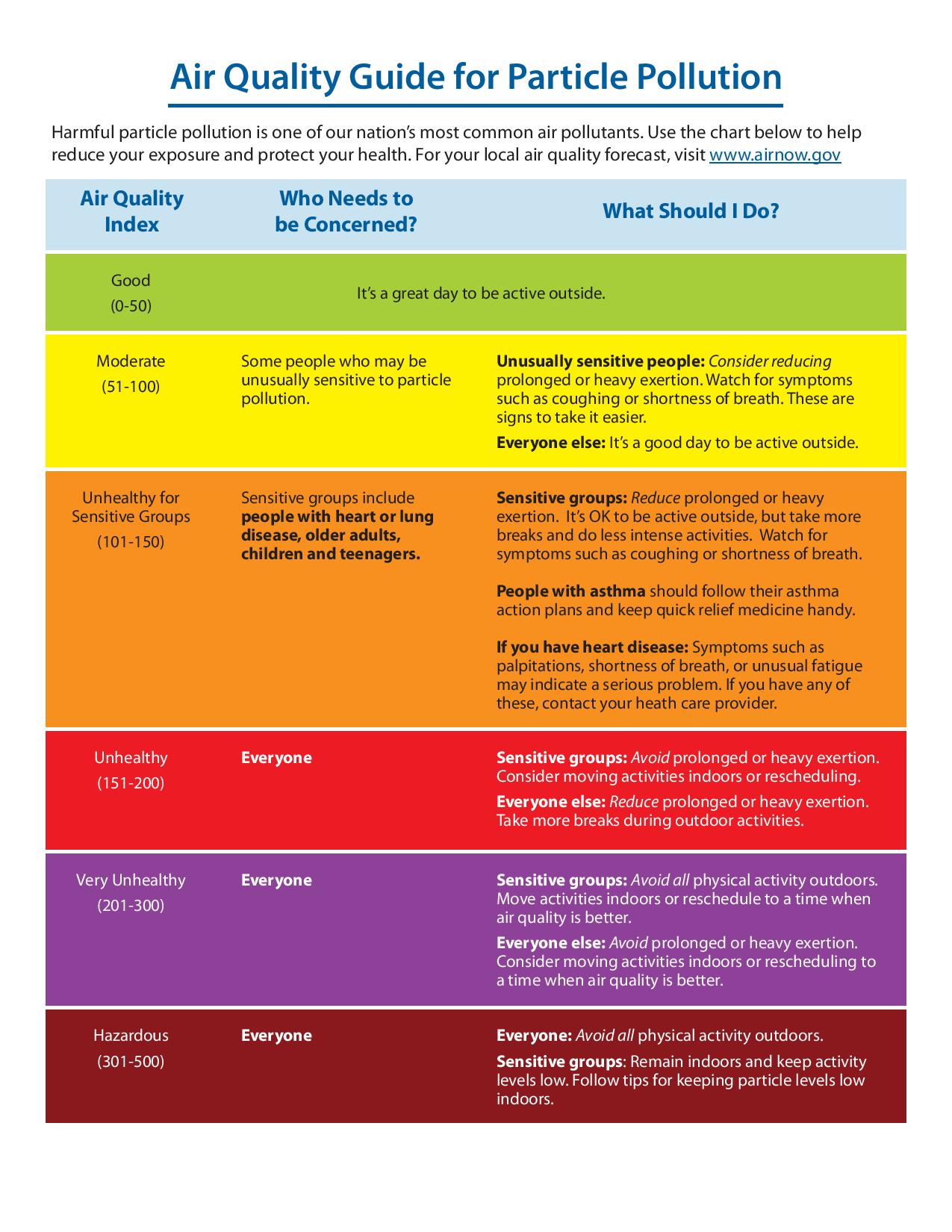
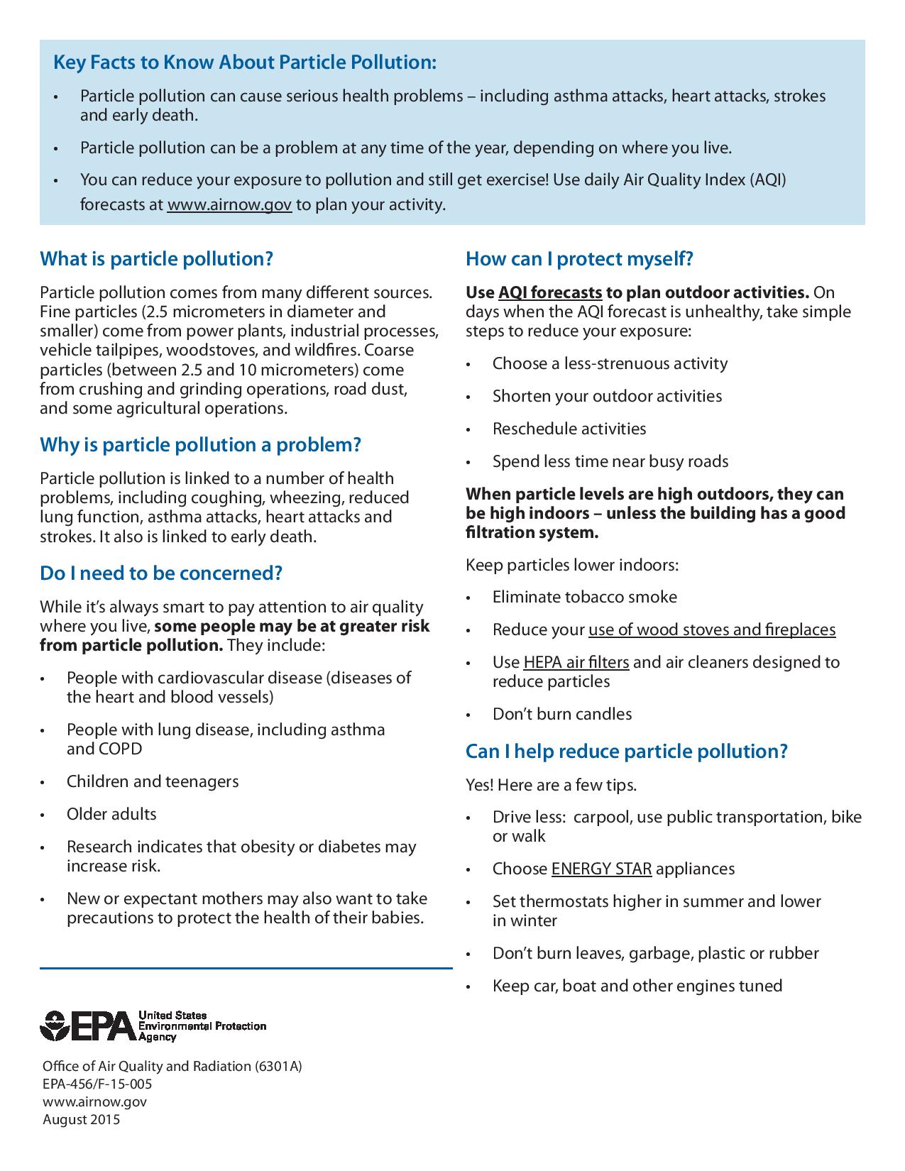
Humo: Humo significativo puede permanecer en áreas circundando el incendio. Algunos individuos son más sensibles que otros. Usted debe tomar medidas para protegerse si tienes síntomas. Mas sugerencias se puede encontrar aquí: https://tinyurl.com/ReduceYourSmokeExposure Actualizaciones de humo son disponible en https://tinyurl.com/DeckerFireSmoke. El pronóstico de humo para Salida y el valle del rio de Arakansas se puede encontrar a https://wildlandfiresmoke.net/outlooks/CentralColorado.
Cierres: Partes de caminos 101 y 101A en el bosque nacional y el Rainbow Trail (camino 1336) sur de camino 108 hacia el Stout Lakes Trail (camino 1403) están cerrados. El camino del candado de Chaffee 101/CR 49 (Bear Creek Road) en el candado de Fremont está cerrado (solo abierto por tráfico local). Se ha emitido una restricción de vuelo temporal (TRF) en el área sobre el incendio a permitir operaciones aéreas. Recuerda: si vuelas, vosotros no podemos. No hay evacuaciones en este tiempo.
Por favor no llama 911 a reportar el comportamiento del incendio Decker o pedir información del incendio. Una línea de información del incendio está disponible. Solo llama 911 para emergencias.
Estadísticas del incendio Decker:
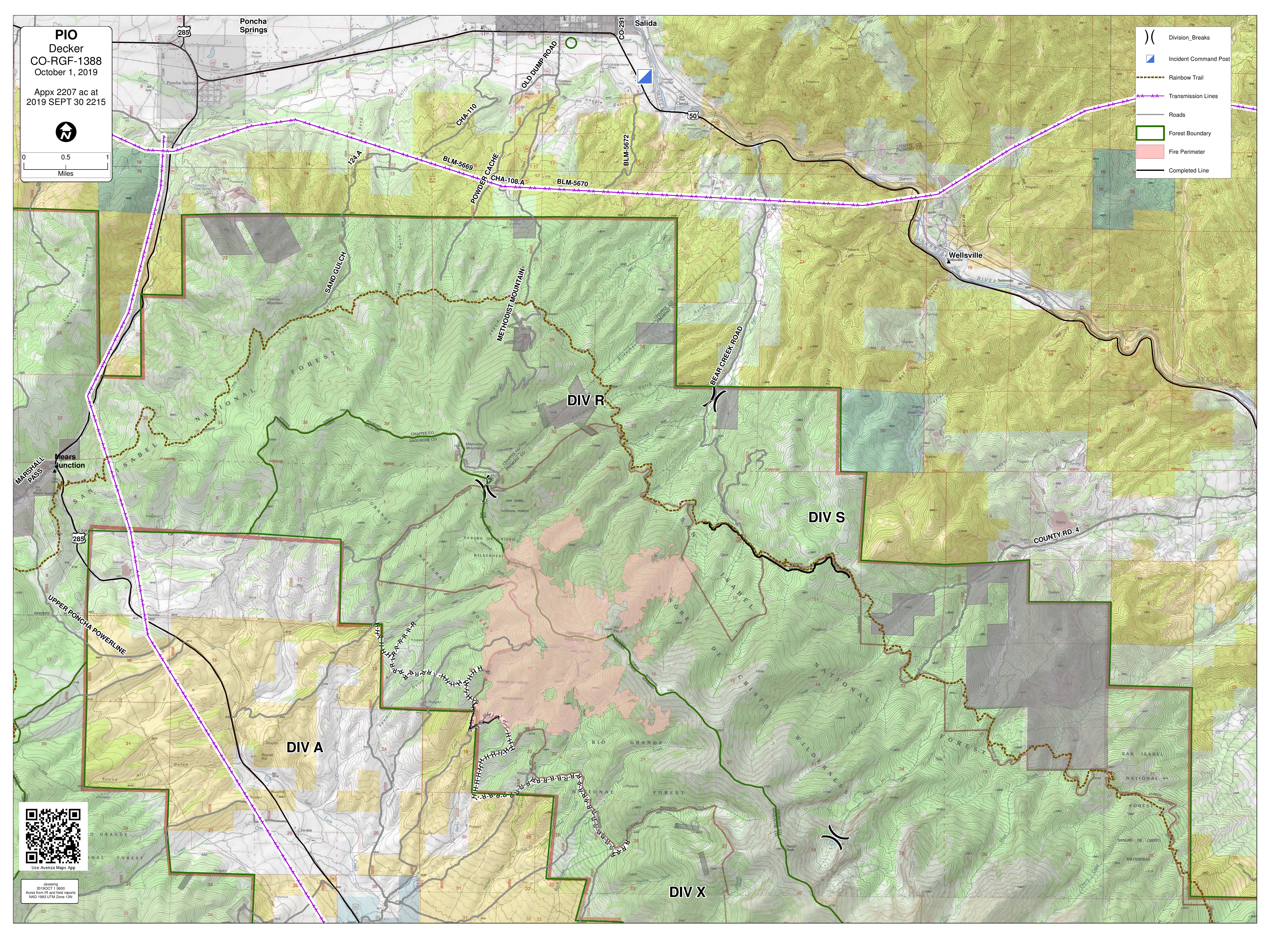
Tamaño: 2207 acres, con contención de 5%
Total de personal: 220
Causa: relámpago
Fecha de inicio: 8 de septiembre 2019
Locación: 9 millas de Salida, CO
Información de contacto:
Línea de información del incendio en inglés: (719) 626-1095 (8am-8pm)
Email: 2019.Decker@firenet.gov
InciWeb: inciweb.ncwg.gov/incident/6592
Facebook: Facebook.com/DeckerFire2019
*Translated by Robert Lemus
Decker Fire More Active with Influence of Strong Winds
Related Incident:
Publication Type: News
Decker Fire Update
October 1, 2019, 10:00 a.m.
Rio Grande National Forest
Pike-San Isabel National Forest
BLM - Front Range Fire and Aviation Management Unit
Justin Yankey, Incident Commander
Decker Fire More Active with Influence of Strong Winds
PUBLIC MEETING: 6:30pm TONIGHT, Oct. 1. The Scout Hut, 210 E. Sackett Ave., Salida, CO 81201
Current Situation: High winds contributed to increased activity on the Decker Fire yesterday. Heavy smoke developed over the fire and could be seen for many miles. In Division S on the northeast, the fire remained calm. Morning bucket work by helicopters helped to slow the spread to the northeast. In Division A on the west, around 3pm, fire activity increased significantly in a previously inactive area. Driven by strong winds from the south, the fire burned northward from the Green Rocks area toward Simmons Peak. This area had dense sections of unburnt fuel, and flame lengths were 80 to 100 feet high at times. A large smoke column developed over the fire, and the fire grew approximately 600 acres. The smoke column appeared so large and dense due to the heavy concentration of dead and down fuel that has built up in the forest over the years. Some “spot fires” were detected in Division R on the San Isabel side near the upper Rock and Bear Creek drainages. The majority of growth was on the western side of the fire within the wilderness boundary. A night shift was established on the fire last night; two engines and a Task Force Leader monitored behavior overnight and will continue to do so as long as they are needed.
Today is another Red Flag Warning day, with low humidity (11-16%) and gusty winds. Fire growth is probable today, with movement likely toward the north. Heavy smoke and plumes are possible. Helicopters will fly this morning to cool spots from yesterday’s growth. Multiple lookouts will be posted to observe for any developments. Crews and dozers on the north will scout for additional opportunities for fireline outside of the wilderness. Structure protection crews will be present in Silver Heels and Bear Creek. As the fire reaches wilderness boundary and safer terrain, firefighters have a much stronger probability of success and can engage in more aggressive suppression efforts. Fire managers have ordered additional resources for this purpose.
The majority of the fire is burning in inaccessible wilderness full of dead and down fuel where it is unsafe for firefighters to go, and where helicopter water drops can only slow and cool the fire. Portions of the wilderness may burn until fuels have been consumed or after a season ending event such as significant and sustained snowfall. Limiting spread onto private and BLM land and ensuring firefighter and public safety remain top priorities.
Weather & Fuel Conditions: Relative humidity recovery was poor last night, and today should be another sunny, dry day with humidities from 11-16%. Temperatures 53-62F. Winds from the SW/S, 15 to 35, with gusts as high as 55. Winds from the SW may align with drainages between 12pm and 3pm and will then shift to come from the south around 3pm. Smoke plumes are most likely between 3pm and 6pm. Critical fire weather and high winds are expected to persist through the week.
Smoke: Significant smoke may remain in areas surrounding the fire. Some individuals may be more sensitive than others. You should take actions to protect yourself if you are having symptoms. Further suggestions can be found here: https://tinyurl.com/ReduceYourSmokeExposure. Real-time smoke information is available at https://tinyurl.com/DeckerFireSmoke. Today’s smoke forecast for Salida and Arkansas River Valley is available at https://wildlandfiresmoke.net/outlooks/CentralColorado.
Closures: Portions of the 101 and 101A roads on National Forest lands and the Rainbow Trail (1336 tail) south of 108 road to the Stout Lakes Trail (1403 trail) have been closed. Chaffee County Road 101/CR 49 (Bear Creek Road) in Fremont County is closed (open to local traffic only). A temporary flight restriction (TFR) has been issued over the fire area to allow for aerial operations. Remember: if you fly, we can’t. There are no evacuations at this time.
Please do not call 911 to report fire behavior on the Decker Fire or to request fire information. A fire information line is available for fire updates. Please call 911 for emergencies only.
Decker Fire Statistics:
Size: 2207 acres, with 5% containment
Total Personnel: 220
Cause: Lightning
Start Date: September 8, 2019
Location: 9 miles south of Salida, CO
Contact Information:
InciWeb: https://inciweb.nwcg.gov/incident/6592/
Facebook: facebook.com/DeckerFire2019
Twitter: #DeckerFire2019
Fire Info Line: (719) 626-1095 (8 a.m. to 8 p.m.)
Email: 2019.Decker@firenet.gov
Vientos fuertes las condiciones de la Alerta Roja continan
Related Incident:
Publication Type: News
Actualizacióndel incendio Decker
30 de septiembre, 2019, 10:00am
Bosque nacional de Rio Grande
Bosque nacional de Pike-San Isabel
BLM- unidad de gestión de incendios y aviación de área metropolitana
Justin Yankey, Comandante del Incidente
Vientos fuertes, las condiciones de la Alerta Roja continúan
Reunión Pública: Mañana 6:30pm, Martes, Oct. 1. The Scout Hut, 2110 E. Sackett Ave., Salida, CO 81201
Humo: Con los vientos del sur ayer, el humo se desplazó a las zonas al norte del incendio, incluyendo Salida y Bear Creek. Esperamos que estas condiciones de viento duren al menos los próximos días. Un Asesor de Recursos Aéreos (experto en humos) está trabajando en el incendio, y estamos monitoreando las condiciones de humo en tres ubicaciones: Salida, Bear Creek y Howard. Para obtener una hoja informativa sobre humo de incendios forestales con recomendaciones visita a este PDF: https://tinyurl.com/ReduceYourSmokeExposure
Situación actual: El comportamiento del incendio se mantuvo moderado ayer; el incendio consumió principalmente combustible que no fue quemado anteriormente dentro del interior del incendio, con sólo 90 acres de nuevo crecimiento. En el lado suroeste, el incendio de las igniciones aéreas del viernes retrocedió lentamente por la colina, consumiendo más combustible en áreas beneficiosas y creando un corte de combustible a lo largo de la cresta. Esto ayuda a prevenir que el incendio no cuesta arriba desde el sur. Las cuadrillas de selección en la División R en el noreste lograron progresos significativos en la línea de mano que están creando a lo largo de la cresta. La línea está casi completa, y pronto se conectará al 101 Rd. El helicóptero K-MAX ayudó con éxito a la propagación lenta del fuego en el lado noreste y fue capaz de volar hasta aproximadamente las 11 de la mañana, cuando los fuertes vientos ya no eran propicios para volar. Las cuadrillas de protección de estructuras preparó y sondaron Bear Creek y Silver Heels. Los camiones de bomberos permanecerán presentes en estas áreas. La mitigación continúa en Pine Ridge. Para reducir la cantidad de tráfico en la carretera 101, las cuadrillas trasladaron el campamento a Vandaveer Property.
Hoy será otro día de Alerta Roja. El K-MAX y un segundo helicóptero "A-Star" más pequeño harán trabajo de cubo esta mañana para enfriar el incendio en el noreste. La mayor parte del día será problemático para los aviones debido al clima / viento. Las cuadrillas de selección asignados al noreste trabajarán para completar la línea de mano que conecta Rainbow Trail y el 101 Rd. Esta línea de mano ayudará a ralentizar la progresión del incendio. Las cuadrillas en otras áreas del incendio seguirán explorando las oportunidades de control usando límites y características naturales y continuar preparando el flanco oeste.
El fuego permanece principalmente en las áreas silvestres; donde sea apropiado, las acciones mantendrán la integridad de las áreas silvestres y permitirán que el fuego promueva naturalmente la salud y la resiliencia de los bosques y reduzca las cargas de combustible peligrosas. A medida que el incendio se acerca a los puntos de acción de gestión, tácticas más agresivas se pueden utilizar para mantener el borde del incendio bajo control. Los administradores de incendios están trabajando en estrecha colaboración con los cooperadores del condado para garantizar que los residentes estén informados y seguros.
Condiciones climáticas y de combustibles: Se espera condiciones secas; humedades del 11 al 16%. Temperaturas 55-65F. Vientos del suroeste son un poco más altos hoy que ayer, 15-30mph, con ráfagas de hasta 55 mph por la tarde. En áreas aisladas, las ráfagas podrían alcanzar 60-65 mph entre las 3pm y las 6pm. Se espera que el clima crítico contra incendios y los fuertes vientos persistan durante la semana.
Evacuaciones y cierres: Partes de caminos 101 y 101A en el bosque nacional y el Rainbow Trail (camino 1336) sur de camino 108 hacia el Stout Lakes Trail están cerrados. Se ha emitido una restricción de vuelo temporal (TRF) en el área sobre el incendio a permitir operaciones aéreas. Recuerda: si no es permitido que vuelen, tampoco podemos volar nosotros. No hay evacuaciones en este tiempo.
Humo: Actualizaciones de humo son disponible en bit.ly/deckerfiresmoke. El pronóstico se puede encontrar a https://wildlandfiresmoke.net/outlooks/CentralColorado. El pronóstico de humo de hoy para Salida y Arkansas River Valley está disponible en https://wildlandfiresmoke.net/outlooks/CentralColorado El fuego y el humo pueden ser visibles desde los corredores US 50 y US 285. Se alienta a los conductores a reducir la velocidad cerca del incendio si el humo afecta la visibilidad, y se pide a motoristas que no paran en la carretera y que estar libre de la carretera antes de observar el incendio. Favor de no llamar al 911 para reportar comportamiento del incendio o pedir información del incendio Decker. Hay una línea disponible para novedades del incendio. El 911 es solo para emergencias.
Estadísticas del incendio Decker:
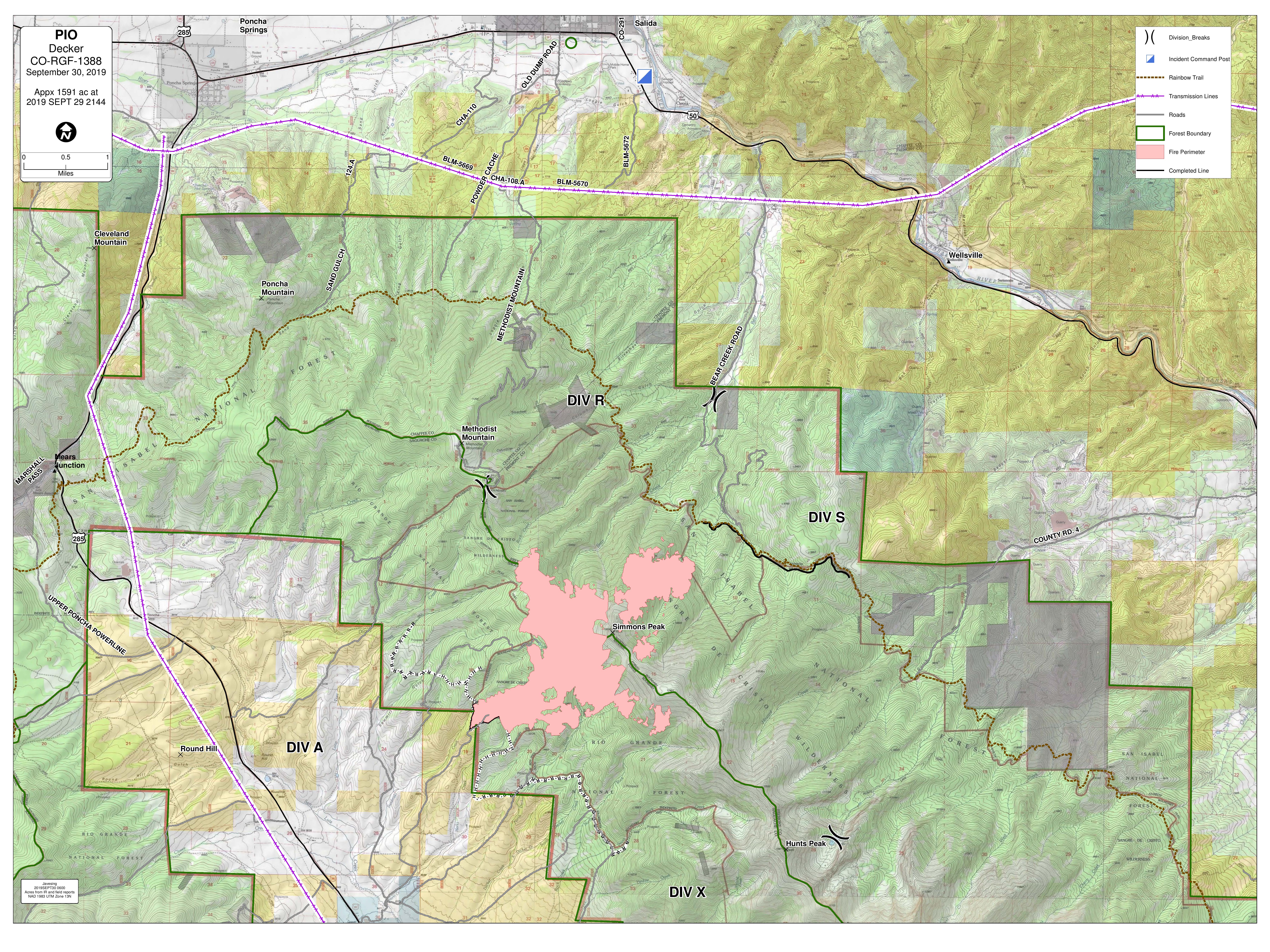
Tamaño: 1591 acres con 5% contenido.
Total de personal: 194
Causa: relámpago
Fecha de inicio: 8 de septiembre 2019
Locación: 9 millas sur de Salida, CO
Información de contacto:
Línea de información del incendio en inglés: (719) 626-1095 (8am-8pm)
Email: 2019.Decker@firenet.gov
InciWeb: inciweb.ncwg.gov/incident/6592
Facebook: Facebook.com/DeckerFire2019
*Translated by Elena A. Jimenez
Strong Winds Red Flag Conditions Continue
Related Incident:
Publication Type: News
Decker Fire Update
September 30, 2019, 10:00 a.m.
Rio Grande National Forest
Pike-San Isabel National Forest
BLM - Front Range Fire and Aviation Management Unit
Justin Yankey, Incident Commander
Strong Winds, Red Flag Conditions Continue
PUBLIC MEETING: 6:30pm TOMORROW, Tuesday, Oct. 1. The Scout Hut, 2110 E. Sackett Ave., Salida, CO 81201
Smoke: With winds from the south yesterday, smoke drifted to areas north of the fire including Salida and Bear Creek. We expect these wind conditions to last for at least the next few days. An Air Resource Advisor (smoke expert) is working on the fire, and we are monitoring smoke conditions at three locations - Salida, Bear Creek, and Howard. Go to this PDF for a wildfire smoke fact sheet with recommendations: https://tinyurl.com/ReduceYourSmokeExposure
Current Situation: Fire behavior remained moderate yesterday; the fire consumed mostly unburned fuel within the interior, as is reflected by only 90 acres of new growth. On the southwest side, fire from Friday’s aerial ignitions slowly backed down the hill, consuming more fuel in beneficial areas and creating a fuel break along the ridge. This helps prevent uphill runs from the south. Hotshots in Division R on the northeast made significant progress on the handline they are creating along the ridgeline. The line is nearly complete, and will soon be connected to the 101 Rd. The K-MAX helicopter successfully helped slow fire spread on the northeast side and was able to fly until approximately 11am when high winds were no longer conducive to flying. Structure protection crews have prepped and plumbed in Bear Creek and Silver Heels, and engines will remain present in these areas. Mitigation continues in Pine Ridge. To reduce the amount of traffic on the 101 road, crews relocated camp to Vandaveer Property.
Today will be another Red Flag Warning day. The K-MAX and a second smaller “A-Star” helicopter will do bucket work this morning to cool fire on the northeast. Most of the day will be problematic for aircraft due to weather/wind. The hotshots assigned to the northeast will work to complete the handline that connects Rainbow Trail and the 101 Rd. This handline will help to slow the progression of the fire. Crews on other areas of the fire will keep scouting for control opportunities using natural boundaries and features and continue to prep the west flank.
The fire remains primarily in Wilderness; where appropriate, actions will maintain wilderness integrity and allow fire to naturally promote forest health and resiliency and reduce hazardous fuel loads. As the fire approaches management action points, more aggressive tactics may be utilized to keep the fire’s edge in check. Fire managers are working closely with county cooperators to ensure that residents are kept informed and safe.
Weather & Fuel Conditions: Dry conditions expected; humidities of 11 to 16%. Temperatures 55-65F. Winds from the SW slightly higher today than yesterday, 15-30mph, with gusts up to 55mph in the afternoon. In isolated areas, gusts could reach 60-65mph between 3pm and 6pm. Critical fire weather and high winds are expected to persist through the week.
Closures: Portions of the 101 and 101A roads on National Forest lands and the Rainbow Trail (1336 tail) south of 108 road to the Stout Lakes Trail (1403 trail) have been closed. Chaffee County Road 101/CR 49 (Bear Creek Road) in Fremont County is closed (open to local traffic only). A temporary flight restriction (TFR) has been issued over the fire area to allow for aerial operations. Remember: if you fly, we can’t. There are no evacuations at this time.
Smoke: Real-time smoke information is available at https://tinyurl.com/DeckerFireSmoke. Today’s smoke forecast for Salida and Arkansas River Valley is available at https://wildlandfiresmoke.net/outlooks/CentralColorado. Fire and smoke may be visible from both the US 50 and US 285 corridors. Motorists are asked to reduce speed if visibility is impacted, and to not stop in the roadway to observe the fire; please be clear of road if you stop. Please do not call 911 to report fire behavior on the Decker Fire or to request fire information. A fire information line is available for fire updates. Please call 911 for emergencies only.
Decker Fire Statistics:
Size: 1591 acres, with 5% containment
Total Personnel: 194
Cause: Lightning
Start Date: September 8, 2019
Location: 9 miles south of Salida, CO
Contact Information:
InciWeb: https://inciweb.nwcg.gov/incident/6592/
Facebook: facebook.com/DeckerFire2019
Twitter: #DeckerFire2019
Fire Info Line: (719) 626-1095 (8 a.m. to 8 p.m.)
Email: 2019.Decker@firenet.gov
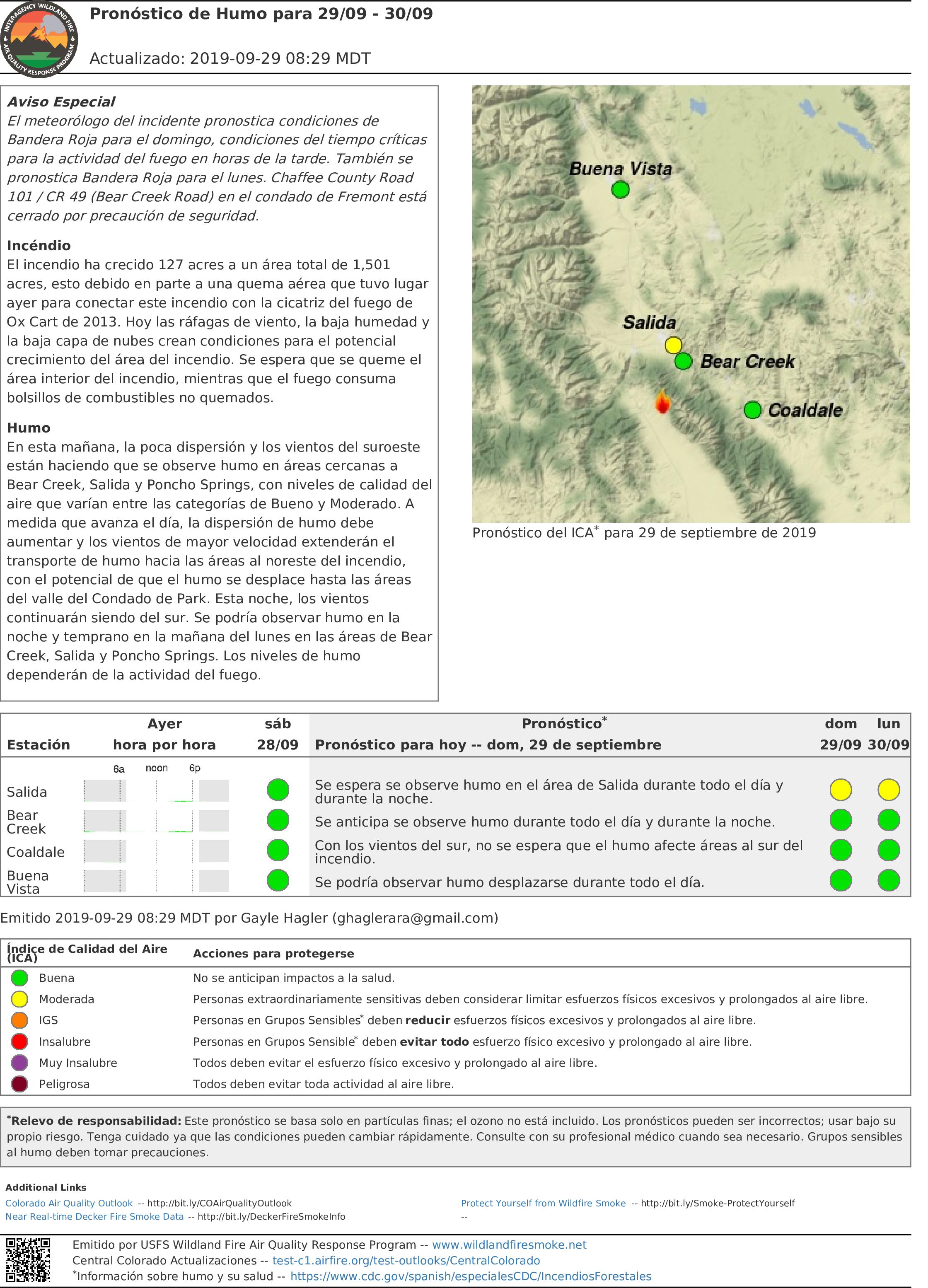
Los bomberos se preparan para el clima crtico de incendio
Related Incident:
Publication Type: News
Actualización del incendio Decker
29 de septiembre, 2019, 10:00am
Bosque nacional de Rio Grande
Bosque nacional de Pike-San Isabel
BLM- unidad de gestión de incendios y aviación de área metropolitana
Justin Yankey, Comandante del Incidente
Los bomberos se preparan para el clima crítico de incendio
Notas especiales: Por el Freemont County Emergency Management, Chaffee County Road 101/CR 49 (Bear Creek Road) en el condado de Fremont está CERRADO con solo tráfico local permitido. SMOKE probablemente será visible desde Salida, Howard y las comunidades circundantes a medida que los vientos aumenten sobre el incendio.
Situación actual: Ayer, las tripulaciones llevaron a cabo con éxito las igniciones aéreas planificadas en el lado sureste del incendio. El aumento visible del humo se debió en gran medida a estas operaciones. El humo también era visible por la noche desde un pequeño parche de combustible no quemado en el drenaje de Merkt. Las igniciones aéreas alcanzaron el objetivo de amarre el fuego activo en una sección de la vieja cicatriz de quemadura de Ox Cart Fire; esto ayuda a limitar el potencial de detección en esta área. En el lado suroeste del incendio, las tripulaciones completaron y mejoraron la línea de fuego hasta el 991 Rd. Donde el 945 Rd. se encuentra con el límite de Rio Grande NF, ahora hay una sección de contención del 5%. (La contención se define como un área donde hay una línea de fuego directa en el borde del fuego, y los pesebres están seguros de que el fuego no cruzará esta línea.) En el lado norte/noreste, los bomberos construyeron la línea de mano indirecta hacia el sur desde el Sendero Arco Iris, atándolo en el escarpado de rocas en el borde del incendio.' El helicóptero K-MAX mantuvo el borde noreste del fuego bajo control con múltiples baldados de agua.
Hoy es el comienzo de un evento de viento de cuatro días de duración, y una Advertencia de Bandera Roja está vigente desde las 12pm hasta las 7pm de domingo a miércoles. Las condiciones climáticas críticas del incendio tienen el potencial de crear cambios repentinos en la dirección del fuego, en su comportamiento y en su intensidad y tamaño. En previsión de este clima crítico de incendio, y para seguir cumpliendo con los objetivos de limitar la propagación del incendio a la propiedad privada y BLM, los administradores de bomberos han aumentado el número de los bomberos y equipos en el Incendio de Los Decker. Actualmente el incendio permanece principalmente entre la naturaleza; cuando sea apropiado, las acciones mantendrán la integridad del incendio y permitirán que el incendio promueva naturalmente la salud y la resiliencia de los bosques. A medida que el incendio se acerca a los puntos de acción de administración, se puede utilizar tácticas más agresivas para mantener el borde del incendio en jaque. Se tomarán las medidas necesarias para mantener a los residentes informados y seguros.
Los equipos en el lado norte/noreste del incendio continuarán construyendo una línea de fuego indirecta hoy, trabajando para unirse a ella a la 101 Rd. Los equipos de protección de la estructura trabajarán con los residentes en los vecindarios de Bear Creek, Silver Creek y Pine Ridge, participando en esfuerzos de mitigación y la creación de espacios defendibles. Las acciones de mitigación incluyen las ramas de las extremidades, el recorte de la vegetación y el establecimiento de sistemas temporales de aspersores.
Condiciones climáticas y de combustibles: La humedad relativa pronosticada en 13 a 18%, temperaturas en los años 60. Los vientos predijeron desde el suroeste a 10-25 mph, ráfagas de hasta 30 mph. En las crestas y en los drenajes, los vientos predijeron ser 20-30 mph, ráfagas de 40-50 mph. Algunos vientos fuertes permanecen de la noche a la mañana. Se espera que las condiciones climáticas críticas del incendio persistan a lo largo de la semana.
Evacuaciones y cierres: Partes de caminos 101 y 101A en el bosque nacional y el Rainbow Trail (camino 1336) sur de camino 108 hacia el Stout Lakes Trail están cerrados. Se ha emitido una restricción de vuelo temporal (TRF) en el área sobre el incendio a permitir operaciones aéreas. Recuerda: si no es permitido que vuelen, tampoco podemos volar nosotros. No hay evacuaciones en este tiempo.
Humo: Humo puede asentarse en el corredor de carretera 50 en la tarde o noche. Se alienta a los conductores a reducir la velocidad cerca de fuego si el humo afecta la visibilidad. Actualizaciones de humo son disponible en bit.ly/deckerfiresmoke. El pronóstico se puede encontrar a https://wildlandfiresmoke.net/outlooks/CentralColorado.
Estadísticas del incendio Decker:
Tamaño: 1501 acres con 5% contenido.
Total de personal: 157
Causa: relámpago
Fecha de inicio: 8 de septiembre 2019
Locación: 9 millas sur de Salida, CO
Información de contacto:
Línea de información del incendio en inglés: (719) 626-1095 (8am-8pm)
Email: 2019.Decker@firenet.gov
InciWeb: inciweb.ncwg.gov/incident/6592
Facebook: Facebook.com/DeckerFire2019
*Translated by Elena A. Jimenez
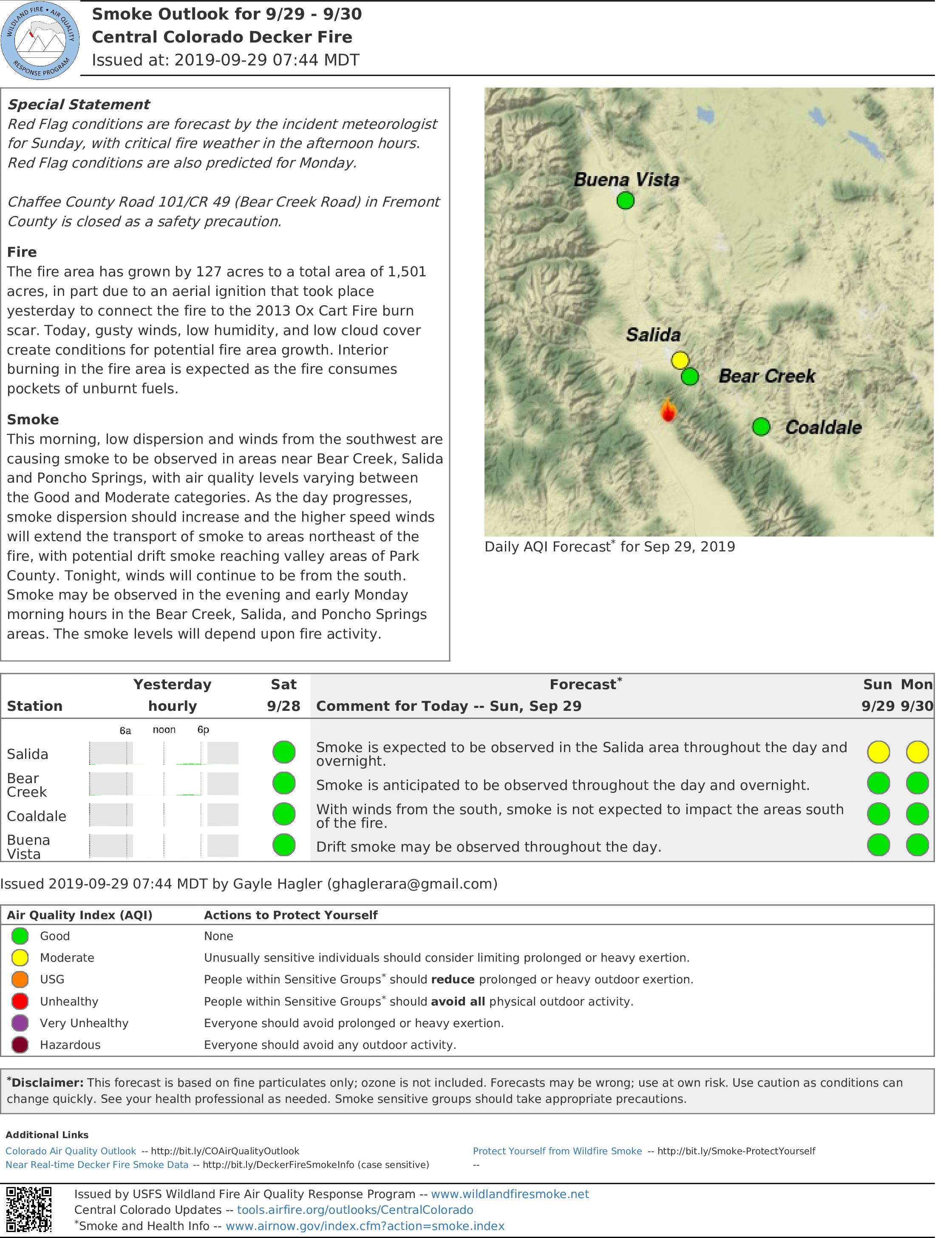
Firefighters Prepare for Critical Fire Weather
Related Incident:
Publication Type: News
Decker Fire Update
September 29, 2019, 10:00 a.m.
Rio Grande National Forest
Pike-San Isabel National Forest
BLM - Front Range Fire and Aviation Management Unit
Justin Yankey, Incident Commander
Special Notes: Per Freemont County Emergency Management, Chaffee County Road 101/CR 49 (Bear Creek Road) in Fremont County is CLOSED with only local traffic allowed. SMOKE will likely be visible from Salida, Howard and surrounding communities as winds increase over the fire.
Current Situation: Yesterday, crews successfully conducted planned aerial ignitions on the southeast side of the fire. The visible increase in smoke was due largely to these operations. Smoke was also visible in the evening from a small patch of previously unburned fuel burning in the Merkt drainage. The aerial ignitions met the goal of tying the active fire into a section of the old Ox Cart Fire burn scar; this helps limit spotting potential in this area. On the southwest side of the fire, crews completed and improved fire line all the way up to the 991 Rd. Where the 945 Rd. meets the Rio Grande NF boundary, there is now a section of 5% containment. (Containment is defined as an area where there is direct fireline at the edge of the fire, and mangers are confident the fire will not cross this line.) On the north/northeast side, firefighters constructed indirect handline south from the Rainbow Trail, tying it into the rock scree right at the fire’s edge. The K-MAX helicopter kept the fire’s northeast edge in check with multiple water bucket drops.
Today is the beginning of a four-day long wind event, and a Red Flag Warning is in effect from 12pm to 7pm Sunday through Wednesday. Critical fire weather conditions have the potential to create sudden changes in fire direction, behavior and growth. In anticipation of this critical fire weather, and to keep meeting objectives of limiting fire spread to private land and BLM, fire managers have increased firefighters and equipment on the Decker Fire. The fire currently remains primarily in Wilderness; where appropriate, actions will maintain wilderness integrity and allow fire to naturally promote forest health and resiliency. As the fire approaches management action points, more aggressive tactics may be utilized to keep the fire’s edge in check. Necessary measures will be taken to keep residents informed and safe.
Crews on the north/northeast side of the fire will continue constructing indirect fireline today, working to join it to the 101 Rd. Structure protection crews will work with residents in the Bear Creek, Silver Creek, and Pine Ridge neighborhoods, engaging in mitigation efforts and creating defensible space. Mitigation actions include limbing branches, trimming vegetation and establishing temporary sprinkler systems.
Weather & Fuel Conditions: Relative humidity forecasted at 13 to 18%, temperatures in the 60s. Winds predicted from the southwest at 10-25 mph, gusts up to 30 mph. On the ridgelines and in drainages, winds predicted to be 20-30 mph, gusts of 40-50 mph. Some strong winds remain overnight. Critical fire weather conditions expected to persist throughout the week.
Closures: Portions of the 101 and 101A roads on National Forest lands and the Rainbow Trail (1336 tail) south of 108 road to the Stout Lakes Trail (1403 trail) have been closed. Chaffee County Road 101/CR 49 (Bear Creek Road) in Fremont County is closed (open to local traffic only). A temporary flight restriction (TFR) has been issued over the fire area to allow for aerial operations. Remember: if you fly, we can’t. There are no evacuations at this time.
Smoke: Smoke may settle into the US Highway 50 corridor in the late afternoons or evenings. Drivers are encouraged to reduce speed near the fire if smoke impacts visibility. Real-time smoke information is available at bit.ly/deckerfiresmokeinfo. Today’s smoke forecast for Salida and Arkansas River Valley is available at https://wildlandfiresmoke.net/outlooks/CentralColorado.
The fire may be visible from both the US 50 and US 285 corridors. Motorists are asked to not stop in the roadway and be clear of the roadway before stopping to observe the fire. Please do not call 911 to report fire behavior on the Decker Fire or to request fire information. A fire information line is available for fire updates. Please call 911 for emergencies only.
Decker Fire Statistics:
Size: 1501 acres, with 5% containment
Total Personnel: 157
Cause: Lightning
Start Date: September 8, 2019
Location: 9 miles south of Salida, CO
Contact Information:
InciWeb: https://inciweb.nwcg.gov/incident/6592/
Facebook: facebook.com/DeckerFire2019
Twitter: #DeckerFire2019
Fire Info Line: (719) 626-1095 (8 a.m. to 8 p.m.)
Email: 2019.Decker@firenet.gov
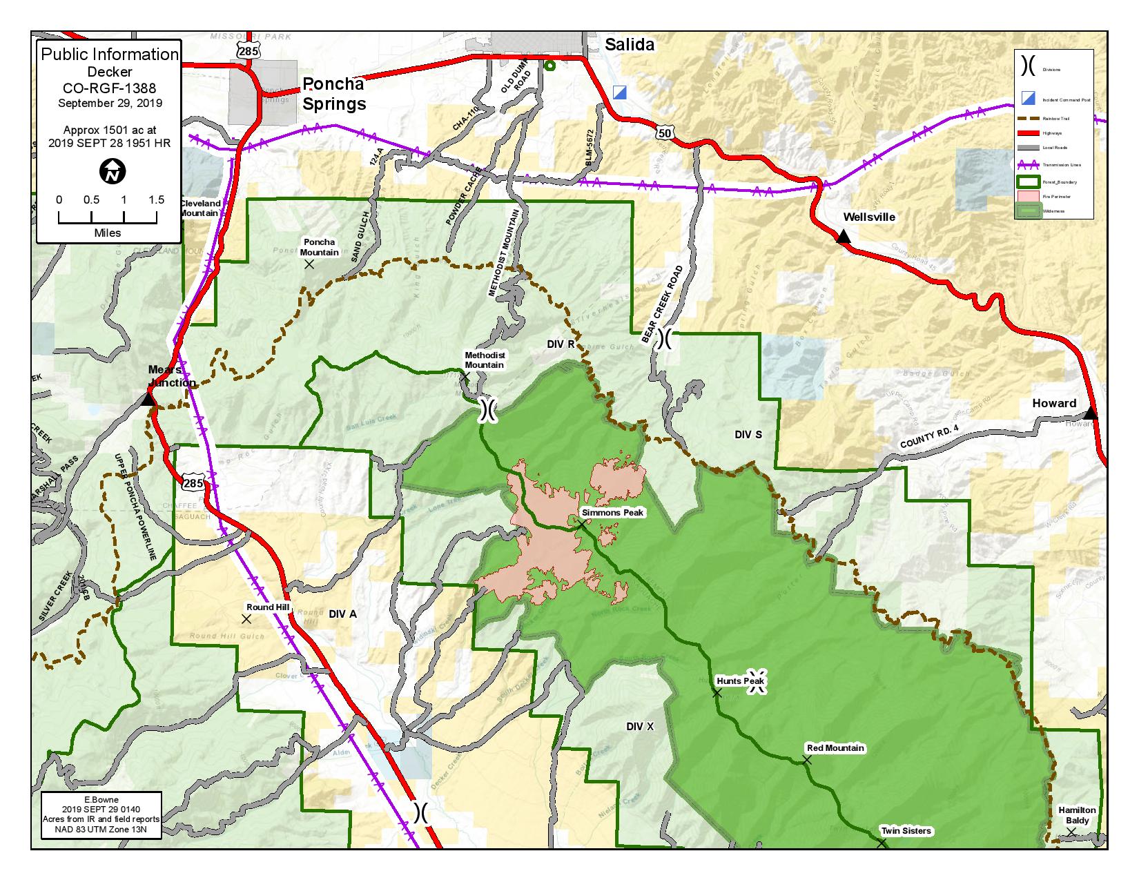
Chaffee County Road 101County Road 49 Closed
Related Incident:
Publication Type: Closures
Chaffee County Road 101/County Road 49 (Bear Creek Road) in Fremont County is closed due to fire operations. Local traffic only is allowed.
Actualizacin del incendio Decker 28 de septiembre 2019 1000am
Related Incident:
Publication Type: News
Más recursos llegan en preparación para las condiciones de Bandera Roja
Situación actual: Los bomberos aprovecharon del leve ayer, reforzando la línea de fuego y explorando oportunidades para acorralar el incendio en la tierra salvaje. Las tripulaciones trabajaron para completar la línea de fuego indirecta en el lado oeste del incendio desde la cicatriz del incendio de Ox Cart hasta la carretera 990. El helicóptero K-MAX ayudó a los bomberos a reducir la velocidad del incendio, que se extendió hasta al drenaje de Bear Creek
Hoy llegan recursos adicionales en previsión de la Advertencia de Bandera Roja emitida para el domingo y el lunes. Las tripulaciones comenzarán a ayudar a los propietarios con la mitigación de combustible en el vecindario de Bear Creek. Las acciones de mitigación incluyen las ramas de las extremidades, el recorte de la vegetación y el establecimiento de sistemas temporales de aspersores. Varios vehículos contra incendio también estarán patrullando en la zona. Estas medidas de precaución crearán un espacio más defendible en este barrio.
Si las condiciones lo permiten, esta mañana puede producirse una operación de ignición aérea planificada en las elevaciones más altas del Bosque Nacional del Río Grande. Esta operación conectará el fuego activo a la cicatriz del incendio de Ox Cart de 2013 para ayudar a asegurar el parámetro sur.
Los recursos aéreos volverán a ser visibles hoy cerca del Rainbow Trail. Las tripulaciones extenderán la línea de fuego hacia el sur, desde Rainbow Trail hasta las formaciones naturales de piedra que está cerca del borde del incendio. Esto reducirá el potencial de propagación de fuego en el drenaje de Bear Creek.
El bosque nacional estima que las áreas dentro de la sierra de Sangre de Cristo tienen hasta un 80% de mortalidad de árboles de ataque de escarabajas y caídas de árboles. El incendio Decker está gestionando parar eliminar estos combustibles de alto riesgo del medioambiente para beneficio ecológico y para reducir el riesgo de incendios forestales catastróficos en el futuro.
El incendio puede ser visible en la noche de los corredores de carreteras 50 y 285. Se pide a motoristas que no paran en la calzada y que estar libre de la calzada antes de observar el incendio. Favor de no llamar al 911 para reportar comportamiento del incendio o pedir información del incendio Decker. Hay una línea disponible para novedades del incendio. El 911 es solo para emergencias.
Condiciones climáticas y de combustibles: Se espera que las temperaturas alcancen los 70 grados con una humedad del 20-25 por ciento. Después de las 10 de la mañana, los vientos estarán fuera del suroeste a 15-20 mph con ráfagas de hasta 35 mph. Las condiciones deben permanecer moderadas hoy debido al aumento de la humedad. El domingo, el aire más seco se traslada a la región, lo que lleva a las condiciones climáticas críticas esperadas del fuego. Se ha emitido una Advertencia de Bandera Roja para el domingo y el lunes
Evacuaciones y cierres: Partes de caminos 101 y 101A en el bosque nacional y el Rainbow Trail (camino 1336) sur de camino 108 hacia el Stout Lakes Trail están cerrados. Se ha emitido una restricción de vuelo temporal (TRF) en el área sobre el incendio a permitir operaciones aéreas. Recuerda: si no es permitido que vuelen, tampoco podemos volar nosotros. No hay evacuaciones en este tiempo. Humo puede asentarse en el corredor de carretera 50 en la tarde o noche. Se alienta a los conductores a reducir la velocidad cerca de fuego si el humo afecta la visibilidad.
Humo: Actualizaciones de humo son disponible en bit.ly/deckerfiresmoke. El pronóstico se puede encontrar a https://wildlandfiresmoke.net/outlooks/CentralColorado.
Estadísticas del incendio Decker:
Tamaño: 1374 acres
Total de personal: 140
Causa: relámpago
Fecha de inicio: 8 de septiembre 2019
Locación: 9 millas sur de Salida, CO
Información de contacto:
Línea de información del incendio en inglés: (719) 626-1095 (8am-8pm)
Email: 2019.Decker@firenet.gov
InciWeb: inciweb.ncwg.gov/incident/6592
Facebook: Facebook.com/DeckerFire2019
*Translated by Elena A. Jimenez
More Resources Arrive in Preparation for Red Flag Conditions
Related Incident:
Publication Type: News
Decker Fire Update
September 28, 2019, 10:00 a.m.
Rio Grande National Forest
Pike-San Isabel National Forest
BLM - Front Range Fire and Aviation Management Unit
Justin Yankey, Incident Commander
More Resources Arrive in Preparation for Red Flag Conditions
Current Situation: Firefighters took advantage of mild fire behavior yesterday, reinforcing fireline and scouting for opportunities to corral the fire in the Wilderness. Crews worked to complete indirect fire line on the west side of the fire from Ox Cart Fire scar to road 990. The K-MAX helicopter assisted firefighters in slowing fire spread into the Bear Creek drainage.
In anticipation of the Red Flag Warning issued for Sunday and Monday, additional resources will arrive today. Crews will begin assisting homeowners with fuel mitigation in the Bear Creek neighborhood. Mitigation actions include limbing branches, trimming vegetation and establishing temporary sprinkler systems. Several engines will be on patrol in the area as well. These precautionary measures will create more defensible space in this neighborhood.
If conditions allow, a planned aerial ignition operation may occur this morning in the higher elevations on the Rio Grande National Forest. This operation will connect the active fire into the 2013 Ox Cart Fire burn scar to help secure the southern parameter.
Aerial resources will be visible again today near the Rainbow Trail. Crews will be extending fireline south from the Rainbow Trail into natural rock features near the fire’s edge. This will reduce the potential of fire spread into the Bear Creek drainage.
The U.S. Forest Service estimates the Sangre De Cristo Wilderness has up to 80% tree mortality from beetle-kill and blowdown. The Decker Fire is being managed to remove these high-risk fuels from the landscape, reduce future risk and restore ecological balance to the forest.
The fire may be visible from both the US 50 and US 285 corridors. Motorists are asked to not stop in the roadway and be clear of the roadway before stopping to observe the fire. Please do not call 911 to report fire behavior on the Decker Fire or to request fire information. A fire information line is available for fire updates. Please call 911 for emergencies only.
Weather & Fuel Conditions: Temperatures are expected to reach 70 degrees with humidity at 20-25 percent. After 10 am, winds will be out of the southwest at 15-20 mph with gusts up to 35 mph. Conditions should remain moderate today due to the increased humidity. Sunday, drier air moves into the region, leading to expected critical fire weather conditions. A Red Flag Warning has been issued for Sunday and Monday
Closures: Portions of the 101 and 101A roads on National Forest lands and the Rainbow Trail (1336 tail) south of 108 road to the Stout Lakes Trail (1403 trail) have been closed. A temporary flight restriction (TFR) has been issued over the fire area to allow for aerial operations. Remember: if you fly, we can’t. There are no evacuations at this time. Smoke may settle into the US Highway 50 corridor in the late afternoons or evenings. Drivers are encouraged to reduce speed near the fire if smoke impacts visibility.
Smoke: Real-time smoke information is available at bit.ly/deckerfiresmokeinfo. Today’s smoke forecast for Salida and Arkansas River Valley is available at https://wildlandfiresmoke.net/outlooks/CentralColorado.
Decker Fire Statistics:
Size: 1374 acres
Total Personnel: 140
Cause: Lightning
Start Date: September 8, 2019
Location: 9 miles south of Salida, CO
Contact Information:
InciWeb: https://inciweb.nwcg.gov/incident/6592/
Facebook: facebook.com/DeckerFire2019
Twitter: #DeckerFire2019
Fire Info Line: (719) 626-1095 (8 a.m. to 8 p.m.)
Email: 2019.Decker@firenet.gov