
Northern Central Valley Smoke Outlook 10520
Related Incident:
Publication Type: News
Fire
The August Complex continues to actively burn across the western half of the fire. Fire crews will conduct burnout operations as needed to meet incident objectives. Expect smoke to once again dictate fire activity.
Smoke
High pressure remains, although the weakening trend continues. Smoke that is trapped in valleys will remain with widespread Unhealthy air. Light easterly winds are forecast today. This will allow for improved air quality for communities east of Interstate 5. Communities on the west half of the Sacramento Valley near canyons could see periods of Very Unhealthy air each morning/night.
To scour out smoke trapped in the valley, it will take a large storm system. At this time, there is no system forecast through at least Wednesday. However, a storm system is possible late this week and into the weekend. This is expected to provide enough southwest winds to help scour the Sacramento Valley out with improved air quality. Stay Tuned!
August Complex Northwest and Northeast Zones Update 1005
Related Incident:
Publication Type: News
August Complex Fire Update Northwest and Northeast Zones
October 5, 2020
Northeast Zone Incident Commander: Norm McDonald
Northwest Zone Incident Commander: Rob Allen
Start Date: 08/17/2020
Cause: Lightning
Containment: 54%
Location: Shasta-Trinity NF; Six Rivers NF; Mendocino NF
Fire Size (All Zones): 1,002,097
Personnel (NW/NE Zones): 2,645
(Redding, CA) – The August Complex has been divided into four zones: Northwest, Northeast, South and West. The dividing line between the Northeast Zone and the Northwest Zone is along South Fork Mountain, crossing State Route 36 near milepost 56 and continuing north along the South Fork Trinity River. Two zones will provide more supervisory personnel, increased oversight and improved the effectiveness of fire resources. Crews who have been working in the Ruth Valley will be the same to preserve that continuity.
Smoke is expected to stay in valleys throughout the day. Light wind at mid-slopes and ridgetops today will be from an easterly direction, and winds may shift to upslope in the afternoon.
Northeast Zone – Yesterday, lower winds and smoky conditions moderated the fire’s behavior, but it continued to spread due to low humidity and dry fuels. Firefighters took advantage of these moderate conditions to strengthen existing containment lines and work directly on firelines where possible.
Along the northern edge of the fire, dozers on both sides of the South Fork Trinity River are building line to tie in with crews working from the east along Forest Road 14. Multiple contingency lines utilizing forest roads and old fuel breaks, northwest of Post Mountain to South Fork Trinity River, are also being improved utilizing dozers followed by hand crews and masticators. Fire crews secured a 6-acre spot fire, yesterday, south of SR 36 in the Rattlesnake Creek drainage near mile marker 68. SR 36 remains closed from the Trinity County line east to State Route 3, due to active fire, hazardous trees and heavy fire traffic.
The fire that spotted over the fire line near Round Mountain, approximately 5 miles south of Wildwood, has become well established and is in the upper Beegum Creek drainage—an area that is difficult to access. There, firefighters are engaging in direct suppression where possible and continue to strengthen contingency lines. The community of Wildwood remains in an Evacuation Warning status as of this morning. Crews are assessing and developing structure protection plans in Wildwood, Platina, and nearby communities.
Northwest Zone – Yesterday, crews responded to and extinguished several spot fires that moved over the line near the SR (Hwy) 36 and South Fork Ridge area. Fixed wing aircraft equipped with infrared sensors were used last night to gain further information that will aid firefighters in locating and snuffing out any further spot fires. Contingency and alternate lines are being identified in the event that the fire moves further north. Firefighters successfully conducted firing operations to reduce fuel in order to protect the Journey’s End structure as well as others in the area. This will attempt to pinch off the fire as it backs down the hillside. Spot fires are being put out and mop up will continue around the southeast side of Ruth Lake. Crews will take advantage of the reduced vegetation within the previous Gobbler and Lassics Fires to slow the spread from Black Lassic towards the west side of the Ruth Lake.
In the Zenia area, crews will improve dozer contingency lines in anticipation of possibly carrying out night firing operations. By doing this in the evening, crews hope to take advantage of the higher humidity and lower winds to safely provide a slow creeping fire to reduce fuel between the fire front and the contingency lines. Along this front, this continued coordination with CAL FIRE is critical to our success is containing this fire. Where crews cannot directly fight the fire due to terrain or safety concerns, they are using indirect techniques such as anchoring to road systems and using dozer lines for containment well ahead of where the fire is currently burning.
Northwest Fire Information #: (707)-867-0965
Northeast Fire Information Line: (530) 628-0039
Email: 2020.Elkhorn@firenet.gov
inciweb.nwcg.gov/incident/6983/
www.facebook.com @ShastaTrinityNF; @SixRiversNF; @MendocinoNF
Trinity County: Evacuation Orders
· Ruth and Ruth Lake
· Forest Glen
· Post Mountain/Trinity Pines
· Three Forks
· Hettenshaw Valley
· Mad River
· Zenia and Kettenpom
· Island Mountain
· The area of Kettenpom south to Kekawaka Creek
· Bear Wallow and Friend Mountain, including Rowdy Bear
· Indian Valley and Hidden Valley
· All areas south of State Route 36 to the Trinity County line
Trinity County: Evacuation Warning
· Wildwood area
Humboldt County: Evacuation Warning
· Areas east of Alderpoint Road to the Trinity County border and south of Showers Pass Road to Mountain Creek
Evacuation Information
Information for evacuees in Trinity and Humboldt counties is available from the Red Cross at 530-276-8034. Sign up for Trinity County Evacuation notifications and other emergency alerts at www.trinitycounty.org/oes/codered
Road Closures
· State Route (SR) 3 at Rattlesnake Road
· Rattlesnake Road at SR 36
· Post Mountain at SR 36
· SR 36 from Humboldt County Line to Bowman Rd
· Zenia Bluffs Road at Humboldt County Line
· Zenia Lake Mountain Road at Peaks Road
· Kekawaka Creek Road to Mendocino County Line
Damage Assessments
Trinity County Office of Emergency Services has been conducting structure damage assessments when it is safe to do so. They may be contacted at: 530-623-8223.
Forest Closures: Shasta-Trinity, Mendocino, and Six Rivers National Forests.
Each forest has closures in place. Individual forest closure information is available online:
· Shasta-Trinity National Forest: https://www.fs.usda.gov/goto/stnf/forestorders
· Mendocino National Forest: https://www.fs.usda.gov/alerts/mendocino/alerts-notices
· Six Rivers National Forest: https://www.fs.usda.gov/alerts/srnf/alerts-notices
Northwest Fire Information #: (707)-867-0965
Northeast Fire Information Line: (530) 628-0039
Email: 2020.Elkhorn@firenet.gov ♦inciweb.nwcg.gov/incident/6983/
www.facebook.com @ShastaTrinityNF; @SixRiversNF; @MendocinoNF
West Zone Fire Update August Complex 1052020
Related Incident:
Publication Type: News
CAL FIRE’s unified team and the U.S. Forest Service are engaged in a coordinated and collaborative response to take suppressive action on the August Complex, which has been reconfigured into four zones, to effectively provide a response for the communities at risk. Due to resource draw down throughout the state, CAL FIRE’s Incident Management Team requested the California National Guard to assist with fire suppression efforts and as a result of CAL FIRE’s request, 138 National Guard personnel are assigned to the incident. Additionally, resources from across the state of California as well as Montana, Texas, Washington and New Jersey have been assigned to assist on the August Complex-West Zone. The August Complex-West Zone has burned 129,299 acres, peaking at a span of 266 miles of fire line to date, and is 55% contained with approximately 1,600 firefighters battling the fire from the air and the ground.
Overnight, the fire vigorously burned with wind-driven torching, spotting and fire runs observed within the interior. Firefighters continued to persevere as smoke and embers pushed back towards crews as they worked to reinforce containment lines, identify any hazards, build indirect lines for firing operations, insert hose lays to support fire lines and protect structures. Today crews are faced with another hot, and dry day. Challenging conditions remain with active spot fires within heavy timber and steep rugged terrain. Assistance continues on the August Complex – North Zone. Incident Commanders are actively monitoring the fire burning in the Yolla Bolly-Middle Eel Wilderness, which is part of the August Complex – North Zone.
North Central Valley Smoke Outlook for 10420
Related Incident:
Publication Type: News
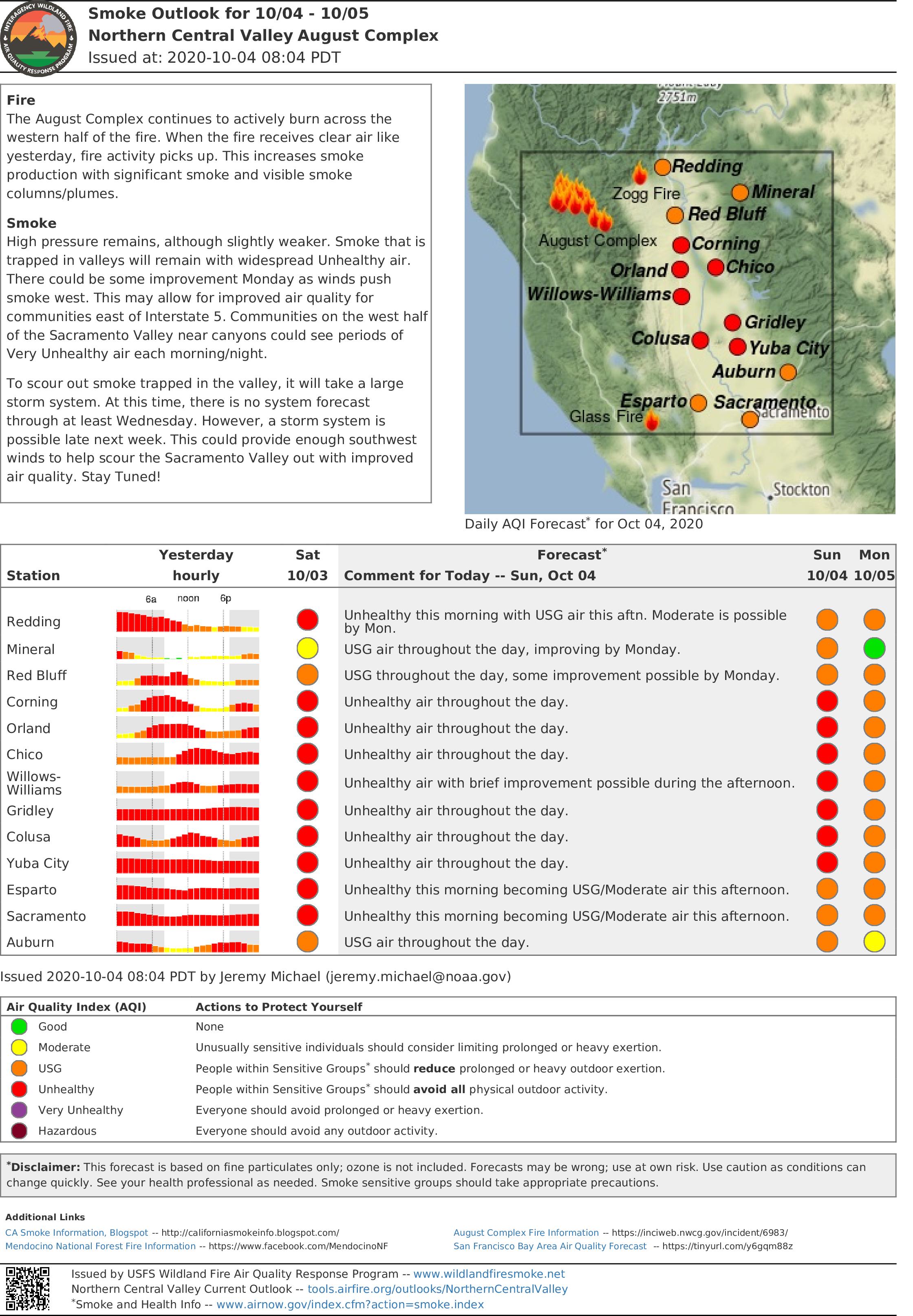
Fire
The August Complex continues to actively burn across the western half of the fire. When the fire receives clear air like yesterday, fire activity picks up. This increases smoke production with significant smoke and visible smoke columns/plumes.
Smoke
High pressure remains, although slightly weaker. Smoke that is trapped in valleys will remain with widespread Unhealthy air. There could be some improvement Monday as winds push smoke west. This may allow for improved air quality for communities east of Interstate 5. Communities on the west half of the Sacramento Valley near canyons could see periods of Very Unhealthy air each morning/night.
To scour out smoke trapped in the valley, it will take a large storm system. At this time, there is no system forecast through at least Wednesday. However, a storm system is possible late next week. This could provide enough southwest winds to help scour the Sacramento Valley out with improved air quality. Stay Tuned!
August Complex South Zone Update 10420
Related Incident:
Publication Type: News
Fire Update: August Complex (South Zone)
Size: 987,654 acres
Containment: 54%
Personnel: 2,327
Start Date: August 17, 2020
Cause: Lightning
Structures Threatened: 2,200
Structures Destroyed: 108
WILLOWS, Calif. – October 4, 2020
YESTERDAY’S ACTIVITIES: Saturday was a transitional day, with Pacific Northwest Team 2 resetting strategy and moving resources to the northwestern corner of the August Complex. The team joined forces with CAL FIRE and the Alaska IMT1 to establish priorities and assign assets to priority areas. As in previous shifts, task forces consisting of multiple fire engines and water tenders continued patrolling containment lines from Eel River, on the west side of the fire, to Lake Pillsbury in the south, and east and north to Paskenta. Also, there was some additional collaboration with CAL FIRE when personnel and resources were assigned to areas east of Covelo and south of Red Rock to share resources and improve dozer lines to gain further containment in that area.
TODAY’S ACTIVITIES: Sunday will have overhead teams in place and solidifying plans, assigning resources, and building strategy to contain active fire on the west and northwest perimeter. In the south zone, quick response resources are strategically placed in case aerial observations discover fire activity that threatens containment lines as winds shift and weather patterns change.
EVACUATIONS: On Friday, Oct. 2, 2020, the Lake County Sheriff reduced the evacuation orders to warnings in the Lake Pillsbury Basin. The EVACUATION ORDERS have been reduced to EVACUATION WARNINGS for all areas north of the fires edge, south and west of the Lake / Glenn County line, and east of the Lake / Mendocino County line. The EVACUATION WARNING remains in effect for all residents in the following area: All residents and areas south of fire’s edge, north of North Ridge and West Crockett Camp, east of the Lake / Mendocino County line and west of the Lake / Glenn County line. Please use this link for the County of Lake GIS map for reference: https://lakecoca.maps.arcgis.com/apps/webappviewer/index.html?id=0f7aa08cc4b74fc6a0c4308d4eace6b3
CLOSURES: Order No. 08-20-14 is in effect for the Mendocino National Forest. Residents and property owners may return to their properties within the Mendocino National Forest in Glenn County and Tehama County, but access to the Forest Service closure area for other purposes, including hunting and recreation, is prohibited. Properties accessed via a Forest System road may require a permit from the US Forest Service. Please contact the Mendocino National Forest at 530-934-3316 for more information.
WEATHER: Widespread haze with patchy smoke will continue Sunday, but otherwise partly sunny, with a high near 93. Light and variable wind becoming southwest 5 to 10 mph in the afternoon. Relative humidity will remain very low, in the 8 to 15% range.
SAFETY: It has been over 170 days since much of the fire area has received over 0.10” precipitation. Conditions still exist for extreme fire behavior, please be careful with fire.
August Complex North Zone Update 1004
Related Incident:
Publication Type: News
August Complex Fire Update October 4, 2020
Northeast Zone Incident Commander: Norm McDonald
Northwest Zone Incident Commander: Rob Allen
Start Date: 08/17/2020
Location: Shasta-Trinity NF; Six Rivers NF; Mendocino NF
Cause: Lightning
Fire Size (All Zones): 987,654
Containment: 54%
Personnel (North Zone): 1,717
(Redding, CA) – Today the August Complex North Zone began operations as two separate geographic areas. The dividing line between the Northeast Zone and the Northwest Zone is along South Fork Mountain through Pickett Peak to State Route 36, crossing SR 36 between mile post 55 and 56, continuing north following the South Fork Trinity River. Two zones will provide more supervisory personnel, increased oversight and improve the effectiveness of fire resources. Crews who have been working in the Ruth Valley will be the same to preserve that continuity.
Northeast Zone – Yesterday, northwest surface winds allowed smoke to clear over the western lake portion of the fire. As the smoke “lid” was lifted, coupled with high temperatures and low humidity, fire activity increased along the perimeter north of SR 36. As those northwest winds interacted with the terrain over the east fire perimeter, southwest terrain driven winds carried spot fires over Forest Road 35 to the east towards Round Mountain and the area where Shasta, Tehama and Trinity Counties intersect.
Fire crews will be assessing and providing structure protection in Wildwood and Platina. Those communities remain under an Evacuation Warning and should be prepared to leave immediately if an Evacuation Order is issued. Firefighters will look for opportunities to safely engage the fire above FR 35.
Crews will continue constructing dozer lines above SR 36 north of Forest Glen and on both sides of the South Fork Trinity River. Multiple contingency lines utilizing forest roads and old fuel breaks northwest of Post Mountain to South Fork Trinity River are being improved. On the east fire perimeter, crews will hold and improve all existing control lines to keep the fire from spreading further beyond of SR 36.
Northwest Zone - Personnel were reallocated from the South Zone to areas near Ruth Lake and the northwest area of the fire. Below South Fork Mountain, the fire has been slowly backing down towards containment lines to the northwest. Where crews cannot directly fight the fire due to terrain or safety concerns, they are using indirect techniques such as anchoring to road systems and using dozer lines for containment well ahead of where the fire is currently burning. Near Zenia the fire crossed existing dozer lines, but progress is being made to contain the fire’s growth with hose lays and crews.
Residents are not permitted entry into evacuated areas until the Sheriff lifts the orders. Public safety officers continue to enforce roadblocks for firefighter and public safety as well as property protection.
Smoke will again have an influence on today’s weather. Temperatures will remain 10 to 15 degrees above normal and relative humidity values will fall into the teens over the mid-slopes and ridges. Winds will not be as strong as yesterday and there will likely be variability with the terrain driven winds.
Fire Information/Media Line: (530) 628-0039
Email: 2020.Elkhorn@firenet.gov
inciweb.nwcg.gov/incident/6983/
www.facebook.com @ShastaTrinityNF; @SixRiversNF; @MendocinoNF
Trinity County
Evacuation Orders
· Ruth and Ruth Lake
· Forest Glen
· Post Mountain/Trinity Pines
· Three Forks
· Hettenshaw Valley
· Mad River
· Zenia and Kettenpom
· Island Mountain
· The area of Kettenpom south to Kekawaka Creek
· Bear Wallow and Friend Mountain, including Rowdy Bear
· Indian Valley and Hidden Valley
· All areas south of State Route 36 to the Trinity County line
Evacuation Warning
· Wildwood area
Humboldt County
Evacuation Warning
· Areas east of Alderpoint Road to the Trinity County border and south of Showers Pass Road to Mountain Creek
Evacuation Information
Residents are urged to evacuate from the fire area. Failure to evacuate diverts firefighters from protecting homes to assisting residents who should have evacuated. Information for evacuees in Trinity and Humboldt counties is available from the Red Cross at 530-276-8034. Sign up for Trinity County Evacuation notifications and other emergency alerts at www.trinitycounty.org/oes/codered
Road Closures
· State Route (SR) 3 at Rattlesnake Road
· Rattlesnake Road at SR 36
· Post Mountain at SR 36
· SR 36 from Humboldt County Line to Bowman Road
· Zenia Bluffs Road at Humboldt County Line
· Zenia Lake Mountain Road at Peaks Road
· Kekawaka Creek Road to Mendocino County Line
Damage Assessments
Trinity County Office of Emergency Services will conduct structure damage assessments when it is safe to do so. They may be contacted at: 530-623-8223.
Forest Closures: Shasta-Trinity, Mendocino, and Six Rivers National Forests.
Each forest has closures in place. Individual forest closure information is available online:
· Shasta-Trinity National Forest: https://www.fs.usda.gov/goto/stnf/forestorders
· Mendocino National Forest: https://www.fs.usda.gov/alerts/mendocino/alerts-notices
· Six Rivers National Forest: https://www.fs.usda.gov/alerts/srnf/alerts-notices.
It is critical that all national forest visitors follow these important closures and restrictions for their own safety and the safety of our firefighters. Many hunting areas are closed due to wildfire activity; for more information visit: https://www.fs.usda.gov/visit/know-before-you-go.
Cooperating Agencies: Trinity County Sheriff’s Office, Humboldt County Sheriff’s Office, Mendocino Sheriff’s Office, Trinity County OES, Humboldt County OES, California Highway Patrol, National Weather Service, BLM, Cal OES, CAL FIRE
West Zone Fire Update August Complex 1042020
Related Incident:
Publication Type: News
CAL FIRE’s unified team and the U.S. Forest Service are engaged in a coordinated and collaborative response to take suppressive action on the August Complex, which has been split into three zones to effectively provide a response for the communities at risk. Due to resource draw down throughout the state, CAL FIRE’s Incident Management Team requested the California National Guard to assist with fire suppression efforts and as a result of CAL FIRE’s request, 138 National Guard personnel are assigned to the incident. Additionally, resources from across the state of California as well as Montana, Texas, Washington and New Jersey have been assigned to assist on the August Complex-West Zone. The August Complex-West Zone has burned 129,299 acres and is 55% contained with approximately 1,600 firefighters battling the fire from the air and the ground.
Saturday, the fire continued to burn vigorously overnight as north, north-west winds and wind gusts continued to push smoke and fire towards firefighters as they worked to strengthen containment lines and protect structures. Uphill and terrain runs, group torching and spotting were observed while firefighters continued to build direct lines where they were able to, build indirect lines for firing operations, and insert hose lays to support fire lines. Another hot, dry day is expected today along with north, north-west winds. Difficult conditions remain with the potential for spot fires within heavy timber and steep and rugged terrain. Assistance continues on the August Complex North Zone. Incident Commanders are actively monitoring the fire burning in the Yolla Bolly-Middle Eel Wilderness, which is part of the August Complex North Zone.
Air Quality Report 10320 for areas near August Complex
Related Incident:
Publication Type: News
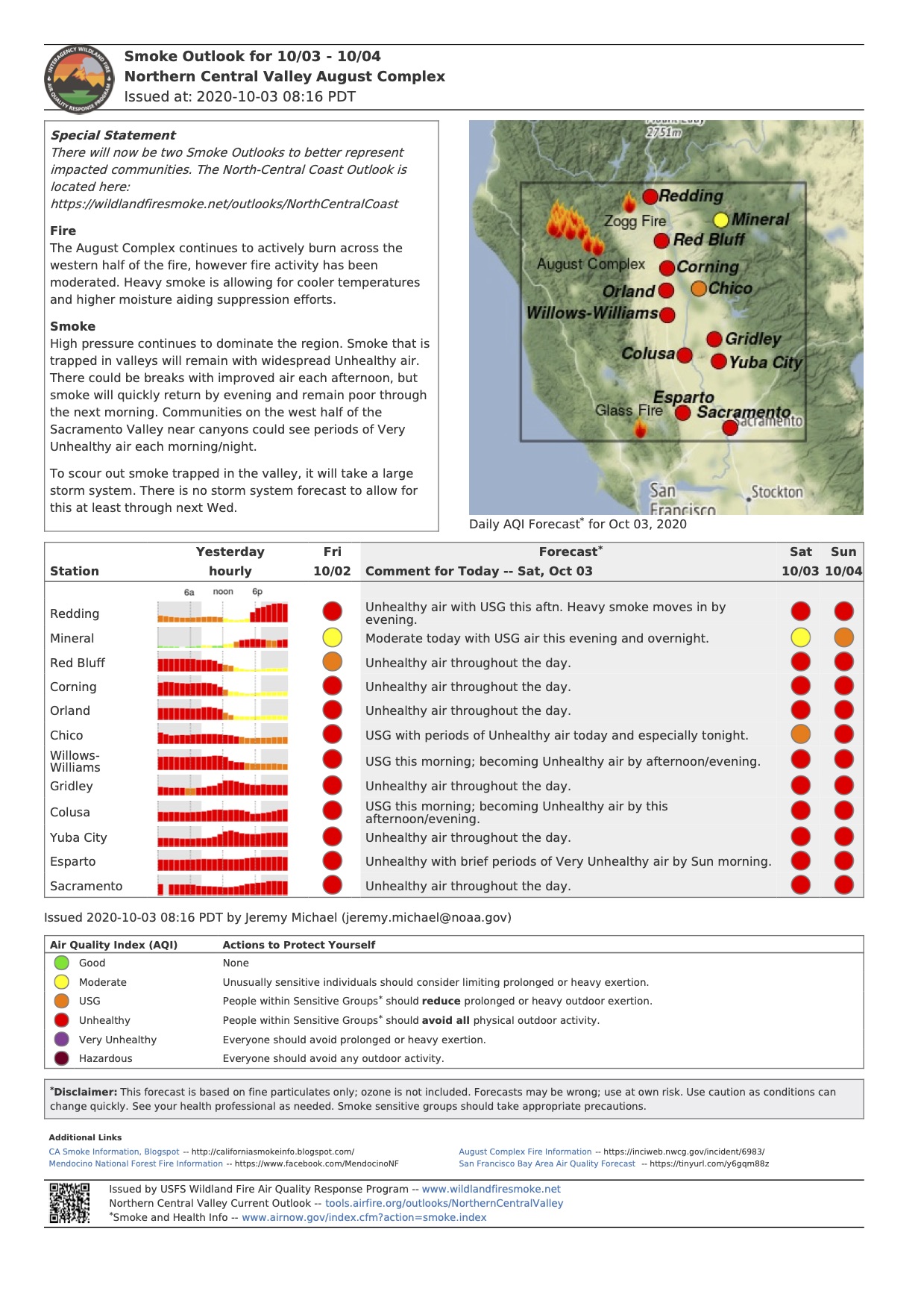
Special Statement
There will now be two Smoke Outlooks to better represent impacted communities. The North-Central Coast Outlook is located here: https://wildlandfiresmoke.net/outlooks/NorthCentralCoast
Fire
The August Complex continues to actively burn across the western half of the fire, however fire activity has been moderated. Heavy smoke is allowing for cooler temperatures and higher moisture aiding suppression efforts.
Smoke
High pressure continues to dominate the region. Smoke that is trapped in valleys will remain with widespread Unhealthy air. There could be breaks with improved air each afternoon, but smoke will quickly return by evening and remain poor through the next morning. Communities on the west half of the Sacramento Valley near canyons could see periods of Very Unhealthy air each morning/night.
To scour out smoke trapped in the valley, it will take a large storm system. There is no storm system forecast to allow for this at least through next Wednesday.
August Complex South Zone Fire Update 10320
Related Incident:
Publication Type: News
Fire Update: August Complex (South Zone)
Size: 979,386 acres Containment: 51% Personnel: 2,327 Start Date: August 17, 2020
Cause: Lightning Structures Threatened: 2,200 Structures Destroyed: 108
WILLOWS, Calif. – October 3, 2020
YESTERDAY’S ACTIVITIES: Another day of hard work in the Lake Pillsbury region has resulted in high confidence in the integrity of the containment lines built to protect property and resources. All hose, fixtures, pumps, and other fire apparatus have been pulled and reset for potential use in the northwestern corner of the August Complex. Patrol status has been achieved at Lake Pillsbury, Rice Creek and adjacent areas.
TODAY’S ACTIVITIES: Sunday will be a transitional day, with Pacific Northwest Team 2 migrating resources and strategy to the northwestern corner of the August Complex. In upcoming shifts, the team will further join forces with CAL FIRE and the Alaska IMT1. Along with that movement, task forces consisting of multiple fire engines and water tenders will continue patrolling the long containment lines from Lake Pillsbury to the west up to Eel River, and east and north to Paskenta.
EVACUATIONS: The Lake County Sheriff reduced the evacuation orders to warnings in the Lake Pillsbury Basin on Friday, Oct. 2, 2020. The EVACUATION ORDERS have been reduced to EVACUATION WARNINGS for all areas north of the fires edge, south and west of the Lake / Glenn County line, and east of the Lake / Mendocino County line. The EVACUATION WARNING remains in effect for all residents in the following area: All residents and areas south of fire’s edge, north of North Ridge and West Crockett Camp, east of the Lake / Mendocino County line and west of the Lake / Glenn County line. Please use this link for the County of Lake GIS map for reference: https://lakecoca.maps.arcgis.com/apps/webappviewer/index.html?id=0f7aa08cc4b74fc6a0c4308d4eace6b3
CLOSURES: Order No. 08-20-14 is in effect for the Mendocino National Forest. Residents and property owners may return to their properties within the Mendocino National Forest in Glenn County and Tehama County, but access to the Forest Service closure area for other purposes, including hunting and recreation, is prohibited. Properties accessed via a Forest System road may require a permit from the US Forest Service. Please contact the Mendocino National Forest at 530-934-3316 for more information.
WEATHER: The current weather pattern will continue through the upcoming weekend, with more hot and dry weather, light and variable winds, and relative humidity bottoming out in the 15% range.
SAFETY: There will be a significant increase in road traffic in fire affected areas as crews and equipment travel to new locations to the north and west of the fire perimeter.
August Complex North Zone Update 1003
Related Incident:
Publication Type: News
August Complex North Zone Fire Update
October 3, 2020
Incident Commander: Norm McDonald
Start Date: 08/17/2020
Location: Shasta-Trinity NF; Six Rivers NF; Mendocino NF
Cause: Lightning
Fire Size (All Zones): 979,386 acres
Containment: 51%
Personnel (North Zone): 1,978
(Redding, CA) – As the size of the incident grows, fire managers and U.S. Forest Service administrators have made the decision to reorganize the incident area into four geographic areas; Northwest Zone, Northeast Zone, South Zone and West Zone. This change is being made to increase oversight and optimize the utilization of resources. One incident management team will be assigned to each zone. The West Zone will continue to be managed by CALFire and the other zones will each be managed by a national Type 1 team.
Favorable weather conditions have allowed firefighters to make good progress in all divisions. On the east flank, the fire remains within the main containment lines. As the fire burns to the south from Red Mountain, crews are working to tie containment lines to the Buck Fire burned area. The fire continues to slowly back down towards State Route 36 along the northeast fire perimeter. To the west on SR 36, the fire has spotted into the Pickett Fire burned area. Crews continue to improve dozer lines and provide structure protection in the Ruth Lake area and to north along Mad River and Van Duzen roads to SR 36. Dozer lines are being constructed utilizing forest roads and old fuel breaks northwest of Post Mountain to South Fork Trinity River to prevent the fire from spreading north towards Hyampom. CALFire is working in the area of Watts Lake, Zenia, and Kettenpom.
Even as firefighters make progress on securing the fire perimeter, fire danger remains extreme with dry vegetation, drought conditions, very low relative humidity, record temperatures, and potential for additional wind events. Fire behavior analysts refer to an index called “Probability of Ignition” (PIG). This rating describes the probability that an ember that lands on dry fuels will ignite a fire. With the extreme dryness of both the fine fuels (grasses, bushes) and the 100-hour and 1,000-hour fuels (larger diameter downed trees), the PIG for this area is now 90%. That means that if 100 embers reach a dry fuel source, 90 of them will start a fire. Given these extreme conditions, please comply with the Sheriff’s orders and leave quickly when an evacuation order is issued. Failure to evacuate diverts firefighters and public safety officers from protecting homes to assisting residents who should have evacuated.
Residents are not permitted entry into evacuated areas until the Sheriff lifts the orders. Public safety officers continue to enforce roadblocks for firefighter and public safety as well as property protection.
A strong ridge of high pressure both at the surface and aloft will prevail across northern California into early next week. Winds will be generally light and terrain driven with continued poor nighttime relative humidity recoveries on mid-slopes and ridgetops. Strong daily inversions will persist, as mixing and transport winds are light, producing areas of thick smoke and limited visibility. In the fire area, temperatures are mainly in the upper 70s to mid-80s, depending on aspect and elevation with daily minimum relative humidity values in the upper teens to mid-20s.
Fire Information/Media Line: (530) 628-0039
Email: 2020.Elkhorn@firenet.gov
inciweb.nwcg.gov/incident/6983/
Facebook and Twitter: @ShastaTrinityNF; @SixRiversNF; @MendocinoNF
Trinity County:
Evacuation Orders
· Ruth and Ruth Lake
· Forest Glen
· Post Mountain/Trinity Pines
· Three Forks
· Hettenshaw Valley
· Mad River
· Zenia and Kettenpom
· Island Mountain
· The area of Kettenpom south to Kekawaka Creek
· Bear Wallow and Friend Mountain, including Rowdy Bear
· Indian Valley and Hidden Valley
· All areas south of State Route 36 to the Trinity County line
Evacuation Warning
· Wildwood area
Humboldt County:
Evacuation Warning
· Areas east of Alderpoint Road to the Trinity County border and south of Showers Pass Road to Mountain Creek
Evacuation Information
Residents are urged to evacuate from the fire area. Failure to evacuate diverts firefighters from protecting homes to assisting residents who should have evacuated. Information for evacuees in Trinity and Humboldt counties is available from the Red Cross at 530-276-8034. Sign up for Trinity County Evacuation notifications and other emergency alerts at www.trinitycounty.org/oes/codered
Road Closures
· State Route (SR) 3 at Rattlesnake Road
· Rattlesnake Road at SR 36
· Post Mountain at SR 36
· SR 36 from Humboldt County Line to Bowman Road
· Zenia Bluffs Road at Humboldt County Line
· Zenia Lake Mountain Road at Peaks Road
· Kekawaka Creek Road to Mendocino County Line
Damage Assessments
Trinity County Office of Emergency Services will conduct structure damage assessments when it is safe to do so. They may be contacted at: 530-623-8223.
Forest Closures: Shasta-Trinity, Mendocino, and Six Rivers National Forests.
Each forest has closures in place. Individual forest closure information is available online:
· Shasta-Trinity National Forest: https://www.fs.usda.gov/goto/stnf/forestorders
· Mendocino National Forest: https://www.fs.usda.gov/alerts/mendocino/alerts-notices
· Six Rivers National Forest: https://www.fs.usda.gov/alerts/srnf/alerts-notices.
It is critical that all national forest visitors follow these important closures and restrictions for their own safety and the safety of our firefighters. Many hunting areas are closed due to wildfire activity; for more information visit: https://www.fs.usda.gov/visit/know-before-you-go.
Cooperating Agencies: Trinity County Sheriff’s Office, Humboldt County Sheriff’s Office, Mendocino Sheriff’s Office, Trinity County OES, Humboldt County OES, California Highway Patrol, National Weather Service, BLM, Cal OES, CAL FIRE