
Big Creek Road Closure
Related Incident:
Publication Type: Announcement
Big Creek Road is currently CLOSED from Bucks Lake Road to Grizzly Loop (just east of the Bucks Lake Fire Station) due to increased fire traffic. Residents can enter the area; however, all other travelers MUST use Bucks Lake Road. Big Creek Road is for Emergency Vehicles ONLY.
Butte County Evacuation Order
Related Incident:
Publication Type: Announcement
EVACUATION ORDER
9.8.20 3:25 p.m.
The Butte County Sheriff’s Office is upgrading the EVACUATION WARNING for the areas of Feather Falls and Clipper Mills to an IMMEDIATE EVACUATION ORDER and expanding the EVACUATION ORDER to include the communities of Berry Creek, Brush Creek and Forbestown, due to the Bear Fire burning in Plumas County that is moving towards Butte County.
TEMPORARY EVACUATION STAGING 215PM 982020
Related Incident:
Publication Type: Announcement
FOR LA PORTE AREA RESIDENTS
Temporary evacuation staging areas are being set up by Yuba County OES to assist us at:
The Dobbins Alcouffee Center, located at:
9185 Marysville Rd, Oregon House, CA
The Ponderosa Community Center, located at:
17103 Ponderosa Way, Brownsville, CA
Butte County EVACUATION WARNING
Related Incident:
Publication Type: Announcement
Butte County EVACUATION WARNING
9.8.20 1:00 p.m.
Due to the Bear Fire burning in Plumas County, BCSO is issuing an EVACUATION WARNING for residents living in the communities of Feather Falls and Clipper Mills.
MANDATORY EVACUATION NOTICE 1150 982020
Related Incident:
Publication Type: Announcement
MANDATORY Evacuation notice!!!!
The town of La Porte and Little Grass Valley Reservoir: All residents, campgrounds, and recreational facilities off Little Grass Valley Road west of Quincy La Porte Road. (This includes Silver Tip Springs, Beach Drive, Onion Cir, Fiddleneck Rd, and all other roads connecting and in that area around the reservoir) and Quincy La Porte Road from Onion Valley to the County Line.
Also Quincy La Porte Road is CLOSED!
You should leave the area immediately!! Evacuate south on Quincy La Porte Road toward Yuba County.
Emergency responders are enroute to issue door to door notifications!
At approximately 10 am, the North Complex fire spotted over the Middle Fork of the Feather River and is burning south of the river.
The spot was estimated at 1,000 acres at that time.
Smoke Outlook 982020
Related Incident:
Publication Type: News
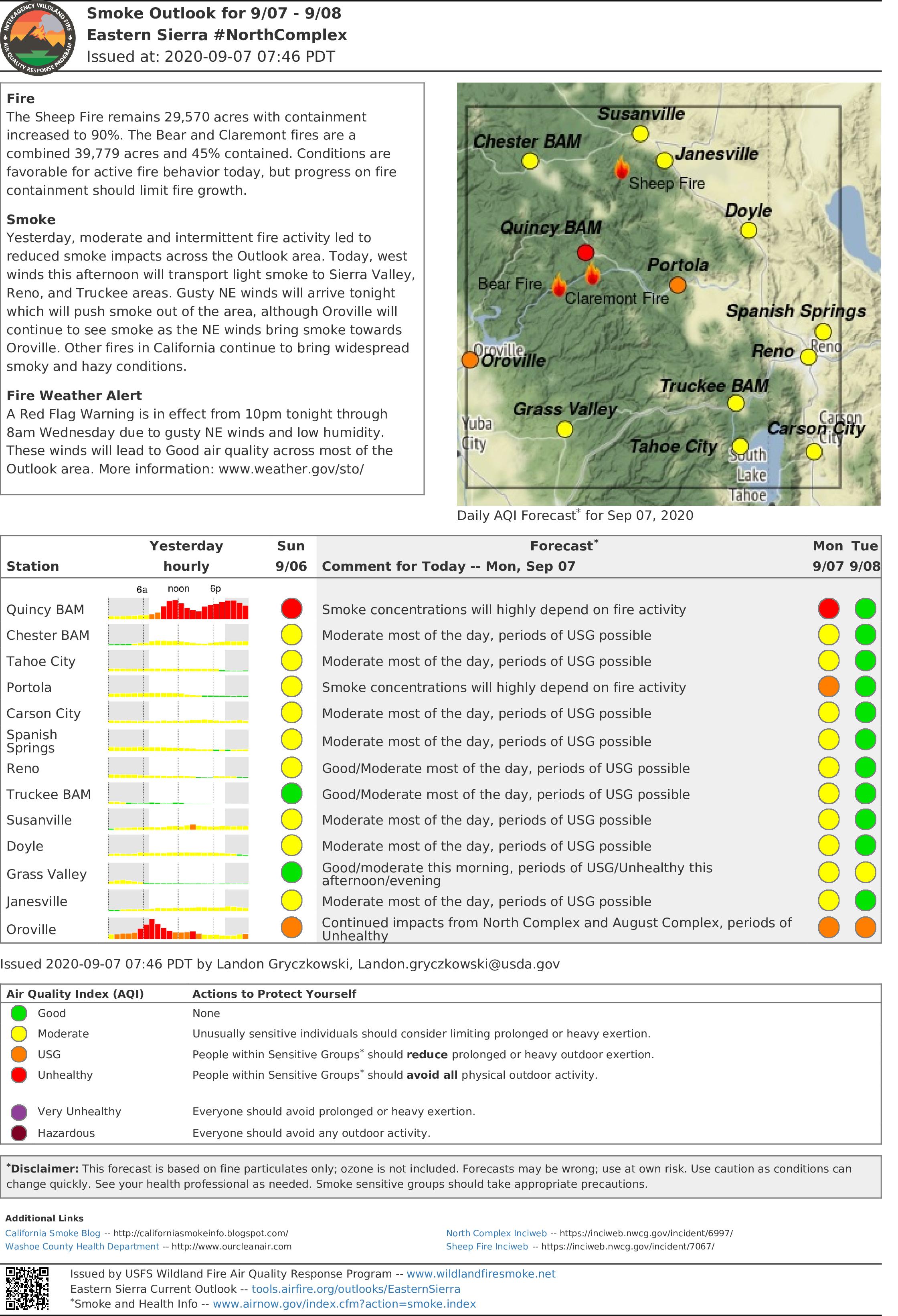
Smoke from new, large wildfires in Washington and Oregon spread into the area and settled into valleys Monday night, combining with smoke from the North Complex and causing higher than expected smoke impacts.
With gusty northeast winds, smoke should clear out by late morning, leading to good air quality across most of the area, lasting until southwest winds return, possibly Thursday. Today and Wednesday, the Oroville area will be both downwind and down canyon of the North Complex and will continue to see intermittent impacts that will depend on fire activity.
Because of increased fire activity, areas southwest of the North Complex around Oroville will see increased smoke which could reach unhealthy to hazardous air quality levels this afternoon through tonight.
Full report here
North Complex Fire Morning Update September 8 2020
Related Incident:
Publication Type: News
Current Situation
Higher wind speeds associated with the dry cold front switched to the east/northeast last night and increased fire rates, flame lengths, and spotting distances. There was a small slopover on the northwest flank of the fire which night crews successfully suppressed with hoses.
Crews will continue to work to hold lines and mop up today while remaining extra vigilant for potential very active fire behavior. Helicopters will be utilized for water drops as winds allow. Firefighter and public safety will remain the priority.
Weather and Air Quality
A Red Flag Warning for gusty northeast winds up to 45 mph and low relative humidity continues into Wednesday morning. Localized stronger winds can be expected in the Middle Fork Feather River drainage and other similarly aligned canyons. For specific smoke impacts to your area, visit www.airnow.gov. Evacuations and Road Closures
Evacuation advisories remain in effect for the Bucks Lake area and Quincy LaPorte Road from Highway 70 south to Thompson Creek. See the Plumas County website for an interactive map: plumascounty.us/2721/North-Complex-Fire-Information. Quincy LaPorte Road is open to residents only. The unpaved portion of Peppard Flat Road is closed.
Forest Closures
A new closure order went into effect at 5 pm yesterday prohibiting the use of any ignition (campfires, gas stoves, etc.) and the closure of all developed campgrounds and day-use sites on National Forests in California. An earlier order remains in effect closing all trails, roads, and campgrounds around the North Complex Fire. Plumas NF: https://www.fs.usda.gov/alerts/plumas/alerts-notices. Lassen NF: www.fs.usda.gov/alerts/lassen/alerts-notices
Meetings are being broadcasted daily through Zoom: · Cooperators Meeting (Tuesday, September 8 at 10 a.m.): https://usfs.zoomgov.com/j/1602646317 · Planning Meeting (Daily at 7 p.m.): https://usfs.zoomgov.com/j/1600484186
California Interagency Incident Management Team 4 is implementing measures to prevent the spread of COVID-19 in both the fire area and surrounding communities
North Complex Evening Update September 7 2020
Related Incident:
Publication Type: News
Current Situation
Evacuations and Road Closures
Forest Closures
Plumas NF: https://www.fs.usda.gov/alerts/plumas/alerts-notices.
Lassen NF: www.fs.usda.gov/alerts/lassen/alerts-notices
EVACUATION INFORMATION UPDATE Plumas County 9520 200 PM
Related Incident:
Publication Type: Announcement
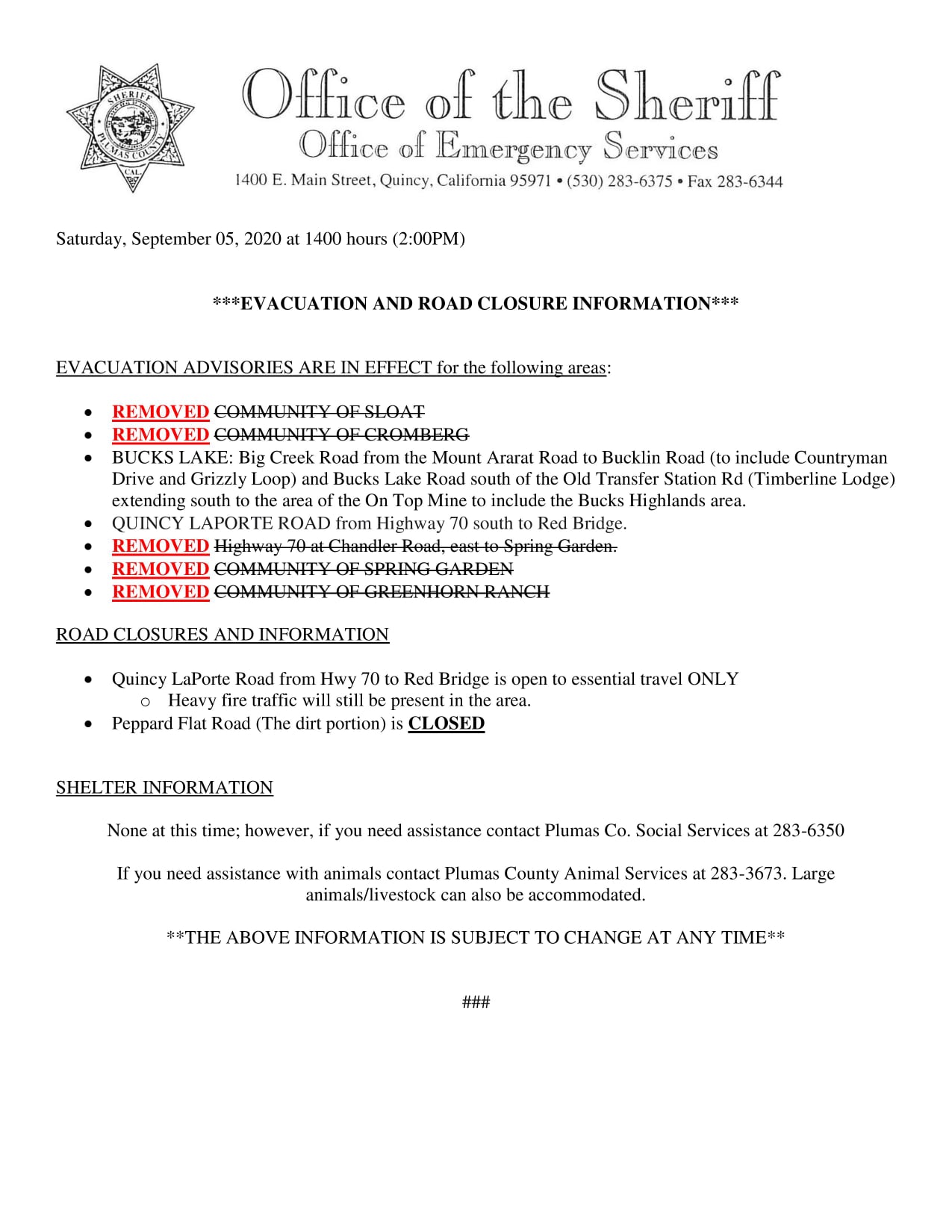
As of 2:00 PM today (09/05/2020), with the support of the California Incident Management Team 4 we are lifting the evacuation advisory for: Greenhorn, Spring Garden, Sloat, Cromberg, and Highway 70 from Chandler Road east to Spring Garden. U.S. Forest Service-Plumas National ForestGreenhorn Creek Volunteer Fire DepartmentLong Valley CSD & Long Valley Volunteer Fire Department
North Complex Morning Update September 7 2020
Related Incident:
Publication Type: News
Current Situation
Night crews secured and mopped up previous firing operations and made great progress on containing previous slopovers and spot fires on the northwest flank. In addition, they detected and addressed a new spot fire near the 40-acre spot which was contained yesterday.
Evacuations and Road Closures
Lassen NF: www.fs.usda.gov/alerts/lassen/alerts-notices
All trails, roads and campgrounds within the forest closure areas are closed.