
Moody Fire Final Update
Related Incident:
Publication Type: News
The Moody Fire is 1,090 acres, 100% contained and has been turned back over to the local fire departments to monitor.
Moody Fire August 29 1115 AM Update
Related Incident:
Publication Type: News
Moody Fire: 1,090 acres, 95% contained
Location: approximately 2 miles south of Del Rio, Texas
Resources have returned to the fire this morning to continue fire suppression efforts. The IC reports that everything is looking good. Engine crews will be patrolling for hot spots and doing any mop up that is needed along the fire perimeter.
Fire Weather: Clear skies and light southeasterly winds prevail this morning with temperatures in the middle 80s. Highs today will top out near 105 degrees with heat index values near 110 degrees. Afternoon humidity values will drop to near 25 percent and winds the afternoon will be out of the south/southeast around 10-14 MPH.
Moody Fire August 28 800 PM Update
Related Incident:
Publication Type: News
Moody Fire: 1,090 acres, 95% contained
Location: approximately 2 miles south of Del Rio, Texas
Resources made significant progress on fire suppression today. Dozer crews will continue to improve containment line while engine crews mop up hot spots along the fire perimeter.
Moody Fire August 28 845 AM Update
Related Incident:
Publication Type: News
Moody Fire: estimated 300 acres, 80% contained
Location: approximately 2 miles south of Del Rio, Texas
Dozer crews will continue to construct and improve containment line around the fire perimeter. Engine crews will continue to mop up any hotspots. Aerial resources will be utilized when available.
Fire Weather: Any chances for wetting rains remain very slim through the weekend. Hot and dry conditions will persist with minimum RH values near 25 percent. Winds will be southeasterly, gusty at times in the late afternoon and evening hours before settling down overnight.
Moody Fire August 27 900 PM Update
Related Incident:
Publication Type: News
Moody Fire: estimated 300 acres, 80% contained
Location: approximately 2 miles south of Del Rio, Texas
Aerial and ground resources made significant progress on fire suppression today. Forward progression has been stopped by locals with county equipment. Dozer crews will return tomorrow to continue to construct and improve containment line. Engines will continue to mop up hotspots.
Sands Fire Final Update
Related Incident:
Publication Type: News
Sands Fire: estimated 2,120 acres, 100% contained
Location: approximately 14 miles south of Kermit, Texas
The Sands Fire is 2,120 acres, 100% contained and has been turned back over to the locals to monitor.
Sands Fire August 27 900 PM Update
Related Incident:
Publication Type: News
Sands Fire: estimated 1,000 acres, 100% contained
Location: approximately 14 miles south of Kermit, Texas
Aerial and ground resources made good progress in fire suppression today. The Sands Fire is estimated 1,200 acres, 100% contained and has been turned back over to the locals to monitor. Crews will return to get better mapping.
Air Quality and Smoke Report 9232020
Related Incident:
Publication Type: Announcement
Fire
Current fire size is 144,708 acres with a growth of 3,108 acres,
containment remains at 33%. Today will see weather patterns
similar to yesterday with expected sudden changes in wind
direction. Critical thresholds for increased fire behavior will
remain present in the afternoon hours with potential for
flareups and spotting. Burnout operations will occur to the
West as well as fire progression to the South-Southeast. Fire
info, visit inciweb.nwcg.gov/incident/7048
Smoke
Air quality across the outlook area is expected to remain
Unhealthy for Sensitive Groups with periods Unhealthy with
weaker Southwest winds resulting in lingering smoke West of
the fire during the day.
Special Note
Smoke Outlook reflects 24 hour particulate matter impacts on
air quality. Review your closest monitoring station when
planning outdoor activities. Air quality may change
unexpectedly. If you begin to notice health effects from
smoke, you are encouraged to follow the "actions to protect
yourself" listed below.
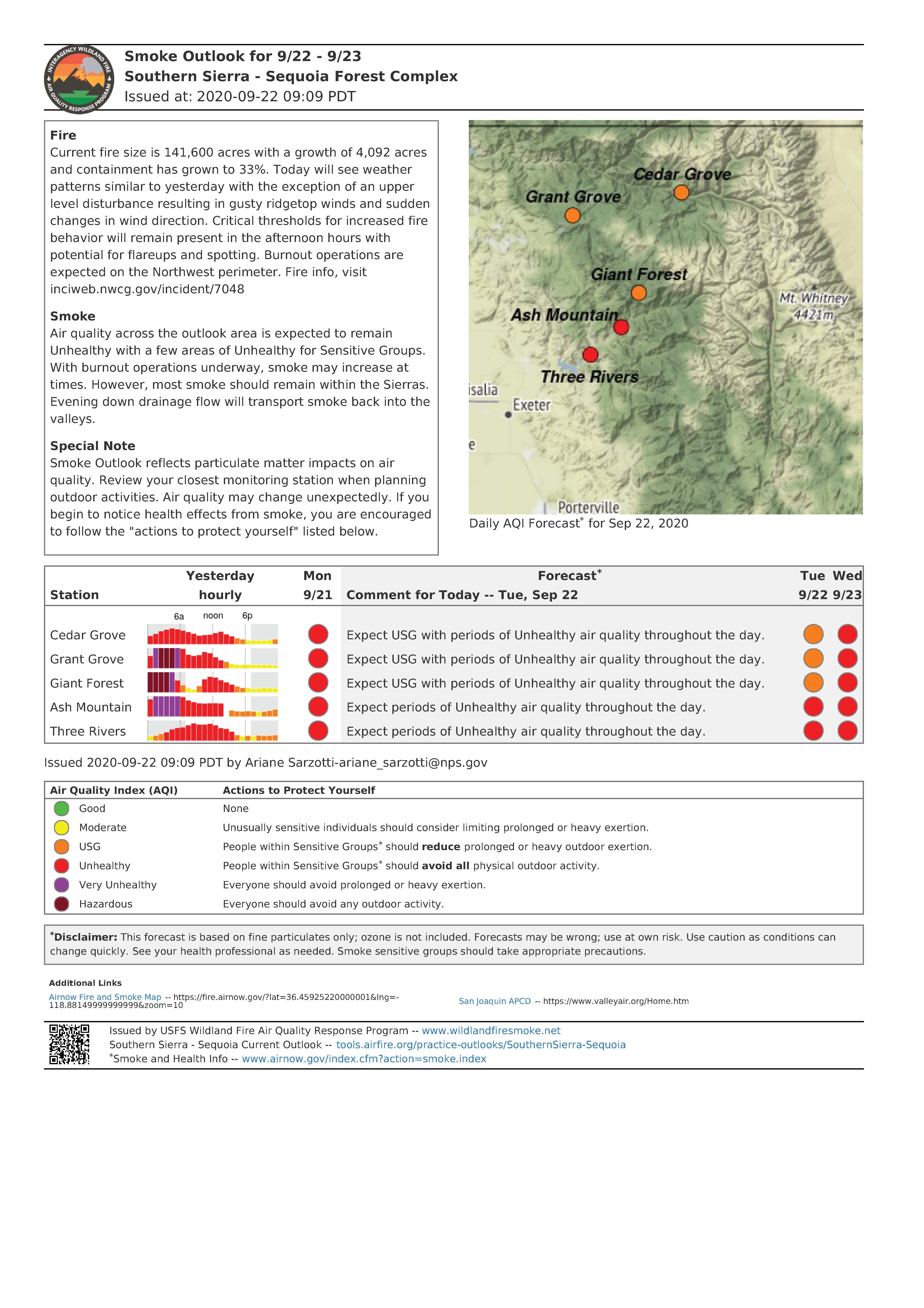
Air Quality and Smoke Report 9222020
Related Incident:
Publication Type: Announcement
Fire
Current fire size is 141,600 acres with a growth of 4,092 acres
and containment has grown to 33%. Today will see weather
patterns similar to yesterday with the exception of an upper
level disturbance resulting in gusty ridgetop winds and sudden
changes in wind direction. Critical thresholds for increased fire
behavior will remain present in the afternoon hours with
potential for flareups and spotting. Burnout operations are
expected on the Northwest perimeter. Fire info, visit
inciweb.nwcg.gov/incident/7048
Smoke
Air quality across the outlook area is expected to remain
Unhealthy with a few areas of Unhealthy for Sensitive Groups.
With burnout operations underway, smoke may increase at
times. However, most smoke should remain within the Sierras.
Evening down drainage flow will transport smoke back into the
valleys.
Special Note
Smoke Outlook reflects particulate matter impacts on air
quality. Review your closest monitoring station when planning
outdoor activities. Air quality may change unexpectedly. If you
begin to notice health effects from smoke, you are encouraged
to follow the "actions to protect yourself" listed below.
Wilderness Fires Continue to Burn in Sequoia Kings Canyon National Parks
Related Incident:
Publication Type: News
SEQUOIA AND KINGS CANYON NATIONAL PARKS, Calif. September 19, 2020 – Sequoia and Kings Canyon National Parks continue to have two active fires burning in designated wilderness with no threats to people or property. The Rattlesnake and Moraine Fires were both caused by lighting and continue to show slow and minor fire growth. The Rattlesnake Fire is 2,078 acres and the Moraine Fire is 575 acres.
Sequoia and Kings Canyon National Parks are in a highly fire-adapted ecosystem. This means that fire has shaped this landscape for thousands of years and the plants and animals have evolved to live with fire. The main example within the parks are the sequoia trees themselves. Not only does the giant sequoia have thick bark to provide protection from high heat sources, the cones have also developed to open only during periods of high temperatures to release seeds, generating new trees. This type of cone is referred to as serotinous. Sequoia trees would not exist today if there was not fire to support them.
In addition to Sequoia and Kings Canyon National Parks full park closures, park managers have implemented a designated wilderness closure in response to the Rattlesnake Fire. Beginning at the south boundary of Sequoia National Park with the intersection of the Great Western Divide, north along the Great Western Divide to Kaweah Gap, southeast to Chagoopa Plateau along the base of the Kaweah Peaks to the Kern Canyon, north to Junction Meadow and the Colby Pass Trail (not included), east along the High Sierra Trail (not included) to the John Muir Trail/PCT (not included), south along the PCT (not included) to the park boundary, and west along the park boundary back to the point of origin.
Smoke remains prevalent in the park and air quality is unhealthy for all people. To learn more, please visit fire.airnow.gov
To learn more about our fires, please visit inciweb.nwcg.gov and click Rattlesnake or Moraine Fire.
-NPS-
About Sequoia and Kings Canyon National Parks’ Fire Management Program
For over fifty years, our mission has been to use the full range of options and strategies available to manage fire in the parks. This includes protecting park resources, employees, and the public from unwanted fire; building and maintaining fire resilient ecosystems; reducing the threat to local communities from wildfires emanating from the parks or adjacent lands; and recruiting, training, and retaining a professional fire management workforce.