
Field Assessment of Burned Areas Video
Related Incident:
Publication Type: News
Soil scientist Wendy Peterman, a member of the Holiday Farm Fire BAER team, outlines the work BAER teams do in the field. Video courtesy of the Incident Management Team managing the Holiday Farm Fire.
https://www.youtube.com/watch?v=hpDMxL3mZlc&feature=youtu.be
Soil Burn Severity Data Released
Related Incident:
Publication Type: News
Soil Burn Severity Data Released
PORTLAND, OR, October 8, 2020 – Burned Area Emergency Response (BAER) specialists from the U.S. Forest Service have finalized the Soil Burn Severity map for the following fires: White River, Riverside, Beachie Creek, Lionshead, Holiday Farm, Archie Creek, and Thielsen. Soil burn severity is classified into 4 levels: unburned, low, moderate and high.
BAER soil scientists used the burn area reflectance classification satellite image product to prioritize places in the field to assess soil burn severity. These individuals sampled accessible sites to evaluate soil changes caused by the fire. In particular, they collected information on ground cover, ash color, soil depth and structure, intact roots, and water repellency in order to build a picture of soil burn severity.
The analysis showed the following distribution of severity by acres:
Lionshead (204,179 acres)
Unburned: 29,313 (14%) | Low: 78,679 (39%) | Moderate: 78,547 (38%) | High: 17,639 (9%)
Beachie Creek (192,631 acres)
Unburned: 8,462 (4%) | Low: 63,280 (33%) | Moderate: 100,920 (52%) | High: 19,968 (10%)
White River (17,774 acres)
Unburned: 2,687 (15%) | Low: 11,265 (63%) | Moderate: 3,391 (19%) | High: 430 (2%)
Riverside (137,792 acres)
Unburned: 18,192 (13%) | Low: 47,548 (35%) | Moderate: 55,118 (40%) | High: 16,934 (12%)
Holiday Farm (173,050 acres)
Unburned: 7,479 (4%) | Low: 42,233 (24%) | Moderate: 107,234 (62%) | High: 16,104 (9%)
Archie Creek (131,419 acres)
Unburned: 11,682 (9%) | Low: 18,666 (14%) | Moderate: 57,855 (44%) | High: 43,216 (33%)
Thielsen (9,921 acres)
Unburned: 914 (9%) | Low: 4,171 (42%) | Moderate: 4,295 (43%) | High: 542 (5%)
Slater
Still being analyzed
BAER post-fire assessment teams use the soil burn severity data to identify if there are areas of concern where increased soil erosion, accelerated surface water run-off, and debris flows have the potential to impact human life and safety, property, and critical natural and cultural resources from rain events. This information helps the BAER team determine areas where potential emergency stabilization treatments may occur.
The Soil Burn Severity map isn’t an erosion risk map but does help define areas where potential increases in the rates of erosion and run-off are expected from steep hillslopes with high and moderate soil burn severity. Areas located downstream from moderate and high soil burn severity may experience increased rates of erosion, debris flows, and surface run-off due to cumulative effects.
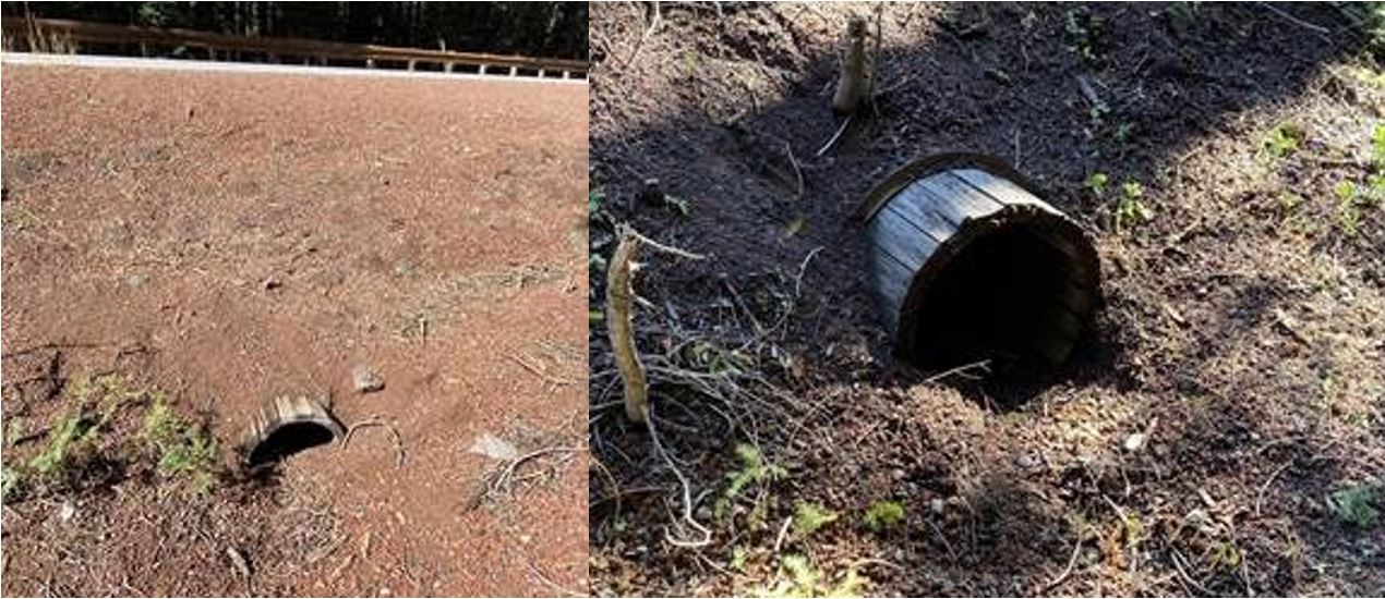
Wooden Culverts Identified by BAER Team on the Umpqua NF
Related Incident:
Publication Type: News
Early 1900s Wooden Culvert identified by BAER team
The USFS BAER team identifies numerous values at risk in the aftermath of a wildfire and determines the threat of additional damage that could be caused by upcoming storms. This wood culvert, identified by a BAER team specialist, is located on a section of the Umpqua River Highway that connects Roseburg to Diamond Lake.
The Umpqua River Highway was constructed by the Civilian Conservation Corps between 1935 and 1939 under the supervision of the Bureau of Public Roads. Road construction in the Umpqua Forest dates to circa 1915. Forest Service maps from 1918 indicate the existence of a developed road connecting Crater Lake to what is now Highway 97. Only a trail extended north to Diamond Lake from Crater Lake at this time.
By 1925, a Forest Service Supply Route existed between Crater Lake and Diamond Lake. Forest Service maps from 1925 also indicate a market road extending east out of Roseburg but ending well short of the western terminus of the North Umpqua Road. The market road and the North Umpqua Road were improved and extended in the 1930s, eventually joining the Diamond Lake Area to the City of Roseburg. The new alignment was incorporated into the state highway system by 1939 and designated as Ore Rte. 138. Eleven wood culverts (unknown construction type), ranging in construction date from 1900 to 1956 have been identified within the state's population of culverts.
Burned Area Emergency Response Team Begins Work on the Archie Creek Fire
Related Incident:
Publication Type: News
Roseburg, Oregon, Oct. 4, 2020 – A Burned Area Emergency Response (BAER) Team started on Saturday, October 3, in Roseburg, Oregon to begin their assessment of the Archie Creek Fire. The fire covered slightly over 131,000 acres within the Umpqua National Forest, Roseburg Bureau of Land Management lands, and neighboring state and private lands.
BAER is an emergency program aimed at managing imminent unacceptable risks to human life and safety, property, or critical natural and cultural resources from post-wildfire damaging events. The primary purpose of the BAER program is to assess and prevent damage from rain events on burned areas.
The Team, comprised of U.S. Forest Service & Department of Interior employees who specialize in multiple resource areas, is conducting field surveys and using science-based models to rapidly assess watersheds on all lands, then inventory values at risk and determine the need for emergency measures and treatments on National Forest lands. The Team will share any areas of concern outside of national forest lands with the appropriate federal, state, and county agencies so they can work with individual landowners under their respective authorities.
Team members will closely assess the watersheds for post-fire rain related impacts such as increased flooding, debris flow potential, and increased soil erosion. The Team then recommends various treatments and time critical treatments to be completed before the first damaging storm event. Those recommendations are submitted as a proposed stabilization plan to the Umpqua National Forest and the Forest Service Pacific Northwest Region (R6) for approval. Once approved, the Forest will receive funding to complete stabilization efforts within the fire area.
Treatments will be installed within one year from the date of full containment and may be monitored for up to three years.
It is anticipated that the fire assessments will be completed by mid-October 2020 with the stabilization plan implemented by the Umpqua National Forest Supervisor shortly after.
For more information regarding this BAER assessment, visit https://inciweb.nwcg.gov/incident/7176/, or contact Dev Dharm Khalsa at dev@projectsinmotion.tv (907) 232-6890 or Anne Poopatanapong at anne.poopatanapong@usda.gov (971) 201-9489
Background BAER information:
Critical Values considered during Burned-Area Emergency Response include:
Human life and safety on or in close proximity to burned National Forest System Lands (NFS).
Buildings, water systems, utility systems, road and trail prisms, dams, wells or other significant investments on or in close proximity to the burned NFS lands.
Water used for municipal, domestic, hydropower, or agricultural supply or waters with special state or federal designations on or in close proximity to the burned NFS lands.
Soil productivity and hydrologic function on burned NFS lands.
Critical habitat or suitable occupied habitat for federally listed threatened or endangered terrestrial, aquatic animal or plant species on or in close proximity to the burned NFS lands.
Native or naturalized communities on NFS lands where invasive species or noxious weeds are absent or present in only minor amounts.
Cultural resources on NFS lands which are listed on or potentially eligible for the National Register of Historic Places.
In short, the purpose of the BAER program is to prevent damage, not repair damage after it occurs.
Specifically, BAER Team specialists determine fire effects for the following resources:
Soil scientists, hydrologists and the geologist evaluate burn severity and assess watershed conditions including the potential for accelerated erosion and runoff from loss of vegetation and charred soils. They use this information to help gauge where runoff might be the heaviest and how to mitigate damage from runoff during heavy rainfall. These scientists work closely with mapping and weather experts in defining how areas may be affected by heavy runoff due to the fire.
Archeologists evaluate the damage to previously recorded historical sites.
Engineers and recreation staff determine the need to eliminate hazard trees along roads and campgrounds within the burn area, and assess other infrastructure.
Fish and wildlife biologists assess habitat conditions related to native fish and wildlife important to the area.
The BAER team will produce and share these key products: Soil Burn Severity Map; Debris Flow Probability Map; and a Watershed Response Map. Other data shared will include calculations of increased peak flow in the evaluated watersheds; calculations of increased soil erosion; and a preliminary list of values at risk based on map and cursory ground surveys.
###
Key Elements of the BAER Assessment
Related Incident:
Publication Type: News
Forest Service BAER assessment teams are established by Forest Supervisors before wildfires are fully contained. The teams coordinate and work with the USDA Natural Resources Conservation Service (NRCS), Bureau of Land Management (BLM), Fish & Wildlife Service (FWS), National Weather Service (NWS), local counties, State Department of Transportation, and other federal, state, and local agencies to strategically assess potential post-fire impacts to the watersheds burned from wildland fires.
- The BAER assessment teams are evaluating watershed conditions to determine the level of potential risks to human life, safety, property, critical natural and cultural-heritage resources, and determine if there are appropriate and effective emergency stabilization measures that can be implemented on federal lands in a timely manner to reduce unacceptable risks from potential flooding and debris flow threats.
- The BAER assessment team conducts field surveys and uses science-based models to rapidly evaluate and assess the burned area.
- BAER assessment teams are staffed by specially trained professionals that may include: hydrologists, soil scientists, engineers, geologists, biologists, botanists, archeologists, geographic information system mapping specialists, recreation and trails specialists, and others who evaluate the burned area and prescribe emergency response actions to protect the land quickly and effectively.
BAER assessments usually begin before a wildfire has been fully contained. - The BAER assessment team generates a “Soil Burn Severity” map by using satellite imagery which is then validated and adjusted by BAER team field surveys to assess watershed conditions and watershed response to the wildfire. The map identifies areas of soil burn severity by categories of low/unburned, moderate, and high which corresponds to a projected increase in watershed response.
- The BAER team presents these findings and treatment recommendations to the Forest Supervisor in an assessment report that identifies immediate and emergency stabilization actions needed to address potential post-fire risks to human life and safety, property, cultural-heritage and critical natural resources on National Forest System lands.
- The BAER report describes watershed pre- and post-fire response information, areas of concern for human life, safety and property, and recommended short-term emergency stabilization actions for federal lands that burned.
- In most cases, only a portion of the burned area is actually treated.
- If the BAER assessment team determines there may be potential emergency situations, the short-term goal is to have flood and erosion control protection measures completed before the first large, damaging rain events occur.
- Timely implementation is critical if BAER emergency response actions are to be effective.
- The BAER assessment team coordinates with other federal and local agencies, and counties that assist private landowners in preparing for increased run-off and potential flooding.
- Federal assistance to private landowners regarding post-fire potential impacts is the primary responsibility of the NRCS through the Emergency Watershed Protection (EWP) program (https://www.nrcs.usda.gov/wps/portal/nrcs/main/national/programs/landscape/ewpp/).
- NRCS in coordination with additional state, local and federal agencies conduct damage survey reports for the private land adjacent to and downstream from the burned areas. NRCS uses these reports, along with the BAER team’s assessment report, to develop recommended emergency measures for businesses and private home and landowners to reduce the impacts to their property from potential increased water and debris flows.
Forest Service BAER Overview
Related Incident:
Publication Type: News
The Burned Area Emergency Response (BAER) program is designed to identify and manage potential risks to resources on National Forest System lands and reduce these threats through appropriate emergency measures to protect human life and safety, property, and critical natural or cultural resources. BAER is an emergency program for stabilization work that involves time-critical activities to be completed before the first damaging event to meet program objectives.
BAER Objectives:
- Determine whether imminent post-wildfire threats to human life and safety, property, and critical natural or cultural resources on National Forest System lands exist and take immediate actions, as appropriate, to manage the unacceptable risks.
- If emergency conditions are identified, mitigate significant threats to health, safety, human life, property and critical cultural and natural resources.
- Prescribe emergency response actions to stabilize and prevent unacceptable degradation to natural and cultural resources, to minimize threats to critical values resulting from the effects of a fire, or to repair/replace/construct physical improvements necessary to prevent degradation of land or resources.
- Implement emergency response actions to help stabilize soil; control water, sediment and debris movement and potentially reduce threats to the BAER critical values identified above when an analysis shows that planned actions are likely to reduce risks substantially within the first year following containment of the fire.
- Monitor the implementation and effectiveness of emergency treatments that were applied on National Forest System lands.
While many wildfires cause minimal damage to the land and pose few threats to the land or people downstream, some fires result in damage that requires special efforts to reduce impacts afterwards. Loss of vegetation exposes soil to erosion; water run-off may increase and cause flooding, soil and rock may move downstream and damage property or fill reservoirs putting community water supplies and endangered species at-risk.
The BAER team presents these findings in an assessment report that identifies immediate and emergency actions needed to address post-fire risks to human life and safety, property, cultural and critical natural resources. This includes early detection and rapid response (EDRR) treatments to prevent the spread of noxious weeds into native plant communities. The BAER report describes watershed pre- and post-fire watershed response information, areas of concern for life and property, and recommended short-term emergency stabilization measures for Forest Service lands that burned.
In most cases, only a portion of the burned area is actually treated. Severely burned areas steep slopes, and places where water run-off will be excessive and may impact important resources, are focus areas and described in the BAER assessment report if they affect critical values. Time is critical if the emergency stabilization measures are to be effective.
A BAER assessment team conducts field surveys and uses science-based models to rapidly evaluate and assess the burned area and prescribe emergency stabilization measures. The team generates a “Soil Burn Severity” map by using satellite imagery which is then validated and adjusted by BAER team field surveys to assess watershed conditions and model potential watershed response from the wildfire. The map identifies areas of soil burn severity by categories of very low/unburned, low, moderate, and high which may correspond to a projected increase in watershed response. The higher the burn severity, the less the soil will be able to absorb water when it rains. Without absorption, there will be increased run-off with the potential of flooding.
BAER Funding:
Special Emergency Wildfire Suppression funds are authorized for BAER activities and the amount of these expenses varies with the severity of the fire season. Some years see little BAER activity while other years are extremely busy.
Because of the emergency nature of BAER, initial requests for funding of proposed BAER treatments are supposed to be submitted by the Forest Supervisor to the Regional Office within 7 days of total containment of the fire. The Regional Forester’s approval authority for individual BAER projects is limited. Approval for BAER projects exceeding this limit is forwarded onto the Washington Office.
Three Phases of Wildfire Recovery
Related Incident:
Publication Type: News
THREE PHASES OF WILDFIRE RECOVERY
There are three phases of recovery following wildfires on Forest Service lands:
- Fire Suppression Repair
- Emergency Stabilization-Burned Area Emergency Response (BAER)
- Long-term Recovery and Restoration
Fire Suppression Repair is a series of immediate post-fire actions taken to repair damage and minimize potential soil erosion and impacts resulting from fire suppression activities. This usually begins before the fire is contained, and before the demobilization of an Incident Management Team. This work repairs the hand and dozer fire lines, roads, trails, staging areas, safety zones, and drop points used during fire suppression efforts.
Emergency Stabilization-Burned Area Emergency Response (BAER) is a rapid assessment of burned watersheds by specialists to identify imminent post-wildfire threats to human life and safety, property, and critical natural or cultural resources on National Forest System lands. If necessary, BAER teams will make recommendations to take immediate actions to implement emergency stabilization measures before the first major storms. Fires result in loss of vegetation, exposure of soil to erosion, and increased water runoff that may lead to flooding, increased sediment delivery, debris flows, and damage to critical natural and cultural resources. BAER actions such as mulching, seeding, installation of erosion and water run-off control structures, temporary barriers to protect recovering areas, and installation of warning signs may be implemented. BAER work may also remove safety hazards, prevent permanent loss of habitat for threatened and endangered species, prevent the spread of noxious weeds, and protect critical cultural resources.
Long-term Recovery and Restoration utilizes non-emergency actions to improve fire-damaged lands that are unlikely to recover naturally and to repair or replace facilities damaged by the fire that are not critical to life and safety. This phase may include restoring burned habitat, reforestation, other planting or seeding, monitoring fire effects, replacing burned fences, interpreting cultural sites, treating noxious weed infestations, and installing interpretive signs.
Creek PostFire BAER Phase III Burn Severity Map Released
Related Incident:
Publication Type: Announcement
Creek Post-Fire BAER Phase III Burn Severity Map Released
In response to the Creek Fire expansive continued growth after the Forest Service Burned Area Emergency Response (BAER) team’s initial Phase I and Phase II assessments of soil burn severity (SBS), a BAER team assessed the new growth areas that are depicted on the Phase III Burn Severity Map in bright pink perimeter lines. During the BAER assessment of Phase I, 306,659 acres were analyzed. For Phase II. 44,430 acres were analyzed. For Phase III, the BAER team assessed and analyzed an additional 29,922 acres using an initial BARC (Burned Area Reflectance Classification) satellite imagery map. The BARC map was validated virtually using topography and aerial imagery—a non-field validated Burn Severity map. Burn Severity levels are Unburned/Very Low, Low, Moderate, and High. The map shows that in the Creek Phase III burned area, the levels are unburned/very low (42%) or low (47%) burn severity, while 11% sustained a moderate burn severity, and less than 1% burned at high burn severity. For information about the Creek Phase I SBS findings, go to InciWeb at: https://inciweb.nwcg.gov/incident/article/7221/57890/.
PLEASE NOTE: Attached below as “Related Information” is a PDF map for the Creek Phase III Post-Fire BAER Burn Severity Assessment. The map is also posted as a JPG image under the Maps Tab, also found at: https://inciweb.nwcg.gov/incident/maps/7221/.
BAER Key MessagesPreparing for Rain
Related Incident:
Publication Type: Announcement
BAER KEY MESSAGES PREPARING FOR RAIN
While many wildfires cause minimal damage to the land and pose few threats to the land or people downstream, some fires cause damage that requires special efforts to manage unacceptable risks afterwards.
Summer thunderstorms and other rain events in the mountains can result in high runoff and flash flooding.
Wildfire increases the potential for post fire flooding, soil erosion, and debris flows that could impact campgrounds, fishing areas, homes, structures, roads, and other infrastructure within, adjacent to, and downstream from the burned areas.
Post-fire, watershed conditions will naturally receive and transport water and sediment differently than during pre-fire conditions.
The public and communities adjacent to and downstream from burned areas should expect increased flooding and debris transport during smaller rain events than would normally cause this.
The potential for increased runoff and debris flows are not just a one-year concern.
We need to recognize the threat potential of flash floods and debris flows may exist for the next 3-5 monsoon and winter seasons, depending on the intensity of these storms.
For life and safety concerns, California National Forest closures may need to be implemented prior to forecast rain events until the burned area fully recovers.
Residents and visitors should remain alert to weather events and plan ahead when travelling along roads downstream from the burned areas of recent wildfires.
Forest Service Burned Area Emergency Response (BAER) teams have been working on California’s National Forests to assess the condition of the watersheds on federal land that burned this summer and fall.
The BAER assessment team identifies potential threats to critical values-at-risk and recommends emergency stabilization response actions that are implemented on federal lands to reduce potential post-fire risks.
BAER critical values that may be considered at-risk on National Forest System (NFS) lands are:
-
Human life and safety.
-
Property on Forest Service lands such as buildings, water systems and infrastructure, road and trail prisms.
-
Natural Resources on Forest Service lands such as water, soil productivity and hydrologic function, areas where invasive species or noxious weeds may impact native or naturalized communities and may include critical habitat or suitable occupied habitat for federally listed threatened or endangered species.
-
Cultural and Heritage Resources such as pre-historic and historic properties and sites on Forest Service lands.
For values and resources potentially impacted off NFS lands, one of the most effective BAER strategies is interagency coordination with other responsible agencies, entities, and local cooperators who assist affected businesses, homes, and landowners prepare for rain events.
While multi-agency efforts are being taken to reduce the risks to life and safety downstream from the burned area, residents in the area should develop individual plans to protect themselves and their property.
The Forest Service and Natural Resources Conservation Service (NRCS) work together and coordinate with other federal, state and local agencies, and counties that assist private landowners in preparing for increased run-off and potential flooding and debris flows.
NRCS works with local sponsors to prepare damage survey reports for eligible sites on private lands adjacent to and downstream from affected areas. NRCS uses these reports, along with the BAER team’s assessment report, to develop emergency measures to reduce the impacts from potential increased water and debris flows, and assist sponsors to implement recommended emergency measures (www.nrcs.usda.gov/Internet/FSE_DOCUMENTS/stelprdb1045263.pdf).
Many local county offices of emergency management promote preparedness through emergency services programs to assist the public to prepare for, respond appropriately to, and quickly recover from natural emergencies that may impact county residents and visitors. Please check your local county website for emergency preparedness for potential National Weather Service flood warnings.
Homes or businesses that could be impacted by flooding from federal land that resulted from wildfires may be eligible for flood insurance coverage from the National Flood Insurance Program (NFIP). Information about NFIP is available through FEMA at www.floodsmart.gov/, or www.floodsmart.gov/flood-insurance/why. Other flood preparedness information is available at www.ready.gov/floods.
SAFETY MESSAGE: Everyone near and downstream from the burned areas should remain alert and stay updated on weather conditions that may result in heavy rains over the burn scars. Flash flooding may occur quickly during heavy rain events be prepared to take action. Current weather and emergency notifications can be found at the National Weather Service website: www.weather.gov/.
Creek PostFire BAER Phase II Soil Burn Severity Map Released
Related Incident:
Publication Type: Announcement
Creek Post-Fire BAER Phase II Soil Burn Severity Map Released
In response to the Creek Fire expansive continued growth after the Forest Service Burned Area Emergency Response (BAER) team’s initial Phase I assessment of soil burn severity (SBS), a BAER team assessed the new growth areas that are depicted on the Phase II SBS Map in bright pink perimeter lines. During the BAER assessment of Phase I, 306,659 acres were analyzed. For Phase II, the BAER team assessed and analyzed an additional 44,430 acres. Soil Burn Severity levels are Unburned/Very Low, Low, Moderate, and High. The map shows that in the Creek Phase II burned area, the SBS levels are unburned/very low (42%) or low (35%) soil burn severity, while 22% sustained a moderate soil burn severity, and less than 1% burned at high soil burn severity. For information about the Creek Phase I SBS findings, go to InciWeb at: https://inciweb.nwcg.gov/incident/article/7221/57890/.
PLEASE NOTE: Attached below as “Related Information” is a PDF map for the Creek Phase II Post-Fire BAER SBS. The map is also posted as a JPG image under the Maps Tab, also found at: https://inciweb.nwcg.gov/incident/maps/7221/.