
Big Bend Fire Suppression Evolves to Repair
Related Incident:
Publication Type: News
NEWS RELEASE
Big Bend Fire Suppression Evolves to Repair
 The South Rim Fire impacted much of the Chisos trail system. Firefighters are working on clearing and assessing damage.
Contact: Tom VandenBerg, 432-477-1107
BIG BEND NATIONAL PARK, TX – With increased success in fire containment and no growth in fire acreage, firefighters at Big Bend National Park have changed the focus from fire suppression to rehabilitation of damaged areas and repair. Where the fire burned hot and any control lines were created, the ground can become channels for erosion if left unrepaired when summer monsoons come.
Firefighters are focusing work in the Boot Canyon area and other High Chisos trails with the removal of downed trees and debris from trails and campsites, where it can be done safely. Due to the presence of firefighters and equipment, the Chisos Mountains area of the Park, including the road, campground, lodge and trails will remain closed to the public until further notice. Crews are also working to ensure safety along trails from falling rocks and timber. Snags and rolling rocks are a watchout throughout the fire area.
“We’re hopeful we can begin to demobilize some crews as soon as this weekend, and possibly reopen the Basin campground and Lodge by the end of the week,” said Big Bend National Park Superintendent, Bob Krumenaker. “But visitors should check the Park web site or social media, or call, before making plans to visit the Basin, as we don’t know for sure when we’ll be able to re-open that area of the Park. We know and appreciate that people are eager to return to the heart of the Park.”
Rehabilitation is being coordinated with resource advisors and park management. When the High Chisos reopens to hikers, visitors will be well aware of the fire, but the National Park Service wants the firefighting effort to be as invisible as possible.
As drying and warming occurs, smokes might be noticed by the public and should not be a cause for alarm. Fire crews are working to ensure that when they are released, the community’s pride and joy is safe and remains a draw for visitors from all over the world.
While the repairs are being implemented, visitors are reminded that Park roads are narrow and there will still be fire vehicles in the area. Drivers are advised to remain vigilant, drive safely and be courteous throughout the Park.
The National Park Service will continue to post regular fire updates and images on Big Bend’s social media feeds. You can also go to https://Inciweb.nwcg.gov. It is an incident information source. Click on the fire location on the map, or type in South Rim 4 in the incident box and you will be able to follow daily updates.
Firefighters Aided by Weather
Related Incident:
Publication Type: News
Firefighters Aided by Weather
 Hot spots still burn in several areas, including in Upper Juniper Canyon. Some of these areas are very difficult to access, and firefighters will continue monitoring and employing helicopter bucket drops as needed.
News Release Date: April 16, 2021
Contact: Tom VandenBerg, 432-477-1107
BIG BEND NATIONAL PARK, TX – An increase in cooler temperatures and higher humidity has significantly paused growth of the South Rim 4 fire over the past 24 hours to 1341 acres and allowed 60% containment. Because there are no control lines in the rocky country, it will take at least several days of monitoring and “cold trailing” to check for hot spots, to increase further containment numbers. More accurate mapping puts the fire at 1341 acres, even though it has not grown.
Crews have begun performing a rehabilitation analysis of trails and backcountry campsites. They will begin clearing hazards such as downed trees and brush across trails. Where it can be done safely, the National Park Service will open trails as quickly as possible once the risks from the fire and its impacts are mitigated, but there’s no time estimate on how quickly that can be done.
Firefighters quickly protected the Chisos Basin development. With the knowledge gained from this incident, they are writing a structure protection plan that will aid in future park fires.
This is the beginning of the 2021 fire season and with this incident, fire staff can hone and improve their skills. An example of this effort was an Emergency Medical Response training exercise, provided by a team from Albuquerque, New Mexico. This is the time for mentoring trainees into multiple levels of the fire organization that not only helps Big Bend, but the national firefighting effort. Incident Commander DW Ivans said, “I am really proud of our fire leadership in this effort.”
The Chisos Mountains area of the park, including the road, campground, lodge and trails will remain closed until further notice. Visitors are requested to check with park personnel regarding which trails and areas are open. There are firefighting vehicles on the narrow roads. This can pose traveling hazards to the public. Drivers are advised to remain vigilant, drive safely and be courteous throughout the park.Fire crews are working together to ensure that when the fire is declared out, and the crews are released, the community will know that their jewel is safe.There is still an abundance of beauty and adventure in other areas of this 801,000-acre national park to be enjoyed by visitors. The fire area is only a little more than 1% of the total park.
The National Park Service will continue to post regular fire updates and images on Big Bend’s social media feeds. You can also go to https://Inciweb.nwcg.gov. It is an incident information source. Click on the fire location on the map, or type in South Rim 4 in the incident box and you will be able to follow daily updates.
 4-15 Map of the South Rim Fire.
Weather Change for South Rim Fire
Related Incident:
Publication Type: News
NEWS RELEASE
Weather Change for the South Rim Fire
 Firefighters hiking to the South Rim Fire
Contact: Tom VandenBerg, 432-477-1107
BIG BEND NATIONAL PARK, TEXAS – Firefighters working the South Rim Fire will be assisted today with cooler temperatures, higher humidity, and the arrival of additional resources. After burning for six days, the South Rim Fire has grown to 873 acres and extended across the summit plateau of Toll Mountain. Several fingers of active burning continue in lower Boot Canyon, Juniper Canyon, and the high ridges of Toll Mountain.
A major change in weather has arrived across West Texas. Today, temperatures in the Chisos Mountains will be in the upper 60s (14 degrees cooler than yesterday), and humidity will drastically improve. Since the fire began last Thursday, firefighters have faced single-digit humidity, but today’s forecast calls for 40-50% humidity which could reduce fire activity.
Today, the Diablos crew and Mount Taylor Hotshots will be focusing on the 7000’ high ridgelines of Toll Mountain. A new crew, the Carson Hotshots are now on scene, and expect to scout the eastern fingers of the fire by hiking up the steep Juniper Canyon Trail. Crews will be directing helicopter water bucket drops as needed this afternoon.
The remote nature of the South Rim Fire makes it challenging for fire management, and difficult for personnel to even reach some of the rugged locations. The park’s mule team has proven invaluable in carrying cargo, water, equipment, and supplies to the hard-working firefighters.
For visitor safety and to provide room for park fire teams to focus on the incident, the Chisos Mountains area of the park, including the road, campground, lodge, and trails will remain closed until further notice. This includes the popular Window and Lost Mine Trails. The fire has not entered the Chisos Basin developed area.
The National Park Service will continue to post regular fire updates and images of the through social media as they become available.
 South Rim Fire Map
 The remote nature of the South Rim Fire makes it challenging for fire management, and difficult for personnel to even reach some of the rugged locations. The park’s mule team has proven invaluable in carrying cargo, water, equipment, and supplies to the hard-working firefighters. Here the mules take a break at the top of the steep Pinnacles Trail.
South Rim Fire Hits 860 acres
Related Incident:
Publication Type: News
South Rim Fire Hits 860 Acres
 Smoke Envelops Boot Canyon
Contact: Tom VandenBerg, 432-477-1107
BIG BEND NATIONAL PARK, TEXAS – After burning for five days, the South Rim Fire has grown to 863 acres and extended through much of the “sky island” of the high Chisos Mountains. Aerial reconnaissance observed that the fire has left a patchy mosaic of scorched, burned, slightly singed, and untouched areas across the South Rim to Emory Peak, and into the lower Boot Canyon drainage. Several fingers of active burning continue, but approximately 2/3 of the fire has stagnated after moving into rocky terrain and cliff edges.
By late Sunday, the Diablos Firefighters were able to cold-trail and contain the entire western flank of the fire, while the Mount Taylor Hotshots worked directly on advancing flames at the Emory Peak/Pinnacles saddle. With the help of carefully coordinated helicopter bucket drops of water, the crews were able to successfully secure that area. During the evening hours, fire climbed the eastern side and across the summit plateau of Toll Mountain. Flames and thick smoke were observed throughout much of the park.
Weather forecasts indicate that the next few days will be cooler and with slightly increased humidity…a welcome respite for the 69 firefighters actively engaged in the fire. They will be focusing on the lower Boot Canyon and Toll Mountain areas today. Helicopter operations will continue this afternoon with potential water drops and more recon flights.
“It takes a team to fight a fire,” said Deputy Superintendent David Elkowitz. “I can’t thank this team enough for the amazing efforts of our firefighters, partners, support personnel, and community members.”
The Chisos Mountain woodlands are home to a variety of plants and animals, many of which are found nowhere else in the United States. These high-elevation desert woodlands have been shaped by wildfire for thousands of years and depend upon fire to keep them healthy and resilient. Many of the areas currently burning have not seen fire for 70 years or more.
For visitor safety and to provide room for park fire teams to focus on the incident, the Chisos Mountains area of the park, including the road, campground, lodge, and trails will remain closed until further notice. This includes the popular Window and Lost Mine Trails. The fire has not entered the Chisos Basin developed area.
The cause of this fire remains unknown at this time, although it appears to have started near a popular backcountry campsite.
The remote nature of the fire creates challenges both for fire management and even getting accurate estimates of fire size and conditions. The National Park Service will continue to post regular fire updates and images of the through social media as they become available.
 Map of the South Rim Fire late Sunday. Current acreage is estimated at 860 acres.
South Rim Fire Reaches Emory Peak
Related Incident:
Publication Type: News
South Rim Fire Reaches Emory Peak
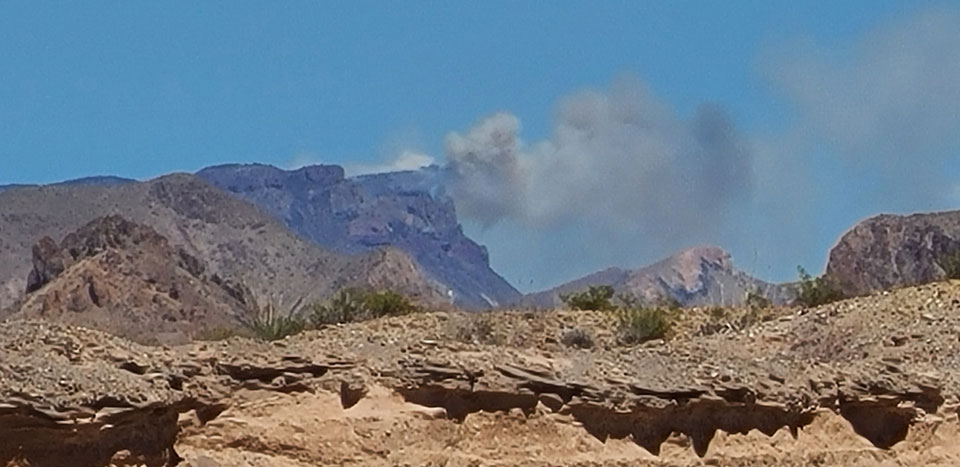
 Smoke on Emory Peak Saturday afternoon 4-10
Contact: Tom VandenBerg, 432-477-1107
BIG BEND NATIONAL PARK, TEXAS – The South Rim Fire has continued to burn through mixed Pinyon-Juniper-Oak woodlands and grass of the high Chisos Mountains, creating plumes of smoke visible throughout the park each afternoon. By late Saturday, about 2/3 of the fire’s perimeter had stagnated after moving into rocky terrain and cliff edges. It is also slowly backing down Boot Canyon.
By 4:00 pm Saturday, fire had crept to the summit ridge of Emory Peak and was visible from the Chisos Basin developed area 1.5 miles away and 1500-2000 feet lower in elevation. Out of an abundance of caution, the National Park Service made the decision to close the Chisos Basin Campground and Chisos Mountains Lodge by sunset. Park Superintendent Bob Krumenaker noted “Visitors and Chisos Mountains Lodge personnel have been extremely cooperative and we were able to clear the Basin faster and more smoothly than we expected. We’re very appreciative. Thanks also to the many NPS staff and volunteers who have been directing traffic and assisting both visitor and the fire team.”
For visitor safety and to provide room for park fire teams to focus on the incident, the Chisos Mountains area of the park, including the road, campground, lodge, and trails will remain closed until further notice. This includes the popular Window and Lost Mine Trails.
Firefighters stayed with the fire last night. Activity quieted down significantly, and the fire did not enter the Chisos Basin overnight. Today, crews will be working on containment along the fire’s slowing edges in the High Chisos and setting up structural protection in the Basin developed area. Structural fire engines will be staged in the Basin area. Sixty nine firefighting personnel, including the Diablos and Mount Taylor Hotshots, are currently fighting the fire at this time. Additional resources will be arriving today, including a helicopter team to provide enhanced recon in the rugged terrain.
Weather forecasts for today call for warmer and drier conditions, which could result in increased fire activity and spread. The fire will no doubt grow beyond yesterday’s 600 acre estimate. Visitors should expect to see smoke, especially during the heat of the afternoon. Initial reports on the current burned areas indicate that much of the fire was low to moderate intensity, which will be beneficial to the long-term health of the Chisos “sky island” ecosystem.
The remote nature of the fire creates challenges both for fire management and even getting accurate estimates of fire size and conditions. The National Park Service will continue to post regular updates and images through social media as they become available.
South Rim Fire Update
Related Incident:
Publication Type: News
South Rim Fire Update

Smoke from the South Rim Fire was visible from all corners of the park on Friday.Subscribe
Contact: Tom VandenBerg, 432-477-1107
BIG BEND NATIONAL PARK, TEXAS – Firefighters working the South Rim Fire faced strong westerly winds and red-flag fire conditions throughout the day yesterday. Steady wind forced the fire to the eastern extent of the Rim, where it ran out of fuel, at which point the flames gradually flanked to the north, extending into the upper reaches of Boot Canyon. Firefighters spent much of the afternoon preparing to defend the Boot Cabin and corrals. At 4:00 pm, firefighters successfully conducted a back burn to protect those structures. A small crew of firefighters remained on scene overnight to monitor the area. The current fire size estimate is 600 acres.
Weather forecasts for today show much promise. Temperatures are slightly cooler, and wind speeds are expected to drop considerably. Incident Commander D.W. Ivans is optimistic that cliffs and rocky terrain will help slow fire spread today and provide opportunities to begin containment. Some additional resources, including a helicopter, will also be arriving today to assist.
“While this is a growing incident, fire in the High Chisos is not unexpected nor a tragedy,” stated Big Bend National Park Superintendent Bob Krumenaker. “I have great confidence in the fire team and everyone at Big Bend appreciates the expressions of support that are coming in. Our foremost objective is to protect human safety, and as part of that, we’re working to keep the fire out of the Basin. I’m optimistic and we ask that park visitors understand that they will likely be inconvenienced. I encourage people to enjoy other parts of this remarkable park for the duration of the incident.”
Today, personnel will be staging equipment and working within the Chisos Basin developed area. All backcountry trails and backpacking campsites in the Chisos Mountains and Outer Mountain Loop will remain closed until further notice. This is for visitor safety, as well as to allow staff to focus all efforts on the fire. The popular Window and Lost Mine Trails remain open for day hiking at this time.
The National Park Service will continue to post regular updates through social media.
Some trails remain closed in Chisos Mountains
Related Incident:
Publication Type: Closures
Closures: A wildfire in the South Rim area of the Chisos Mountains has resulted in closures of certain trails in the Chisos Mountains
Closed Trails:
- Pinnacles Trail
- Emory Peak Trail
- South Rim Trail
- East Rim Trail
- Boot Canyon Trail
- Juniper Canyon Trail
- Colima Trail
Reopening: The Chisos Basin to Reopen Friday, April 23rd at 11:00 a.m.
The following hiking trails will also reopen on Friday:
- Window Trail
- Lost Mine Trail
- Basin Loop Trail
- Laguna Meadows Trail
- Blue Creek Trail
Dodson Trail
Monday, April 26th:
Backpacking campsites along the Laguna Meadows and Blue Creek Trails will reopen on Monday, April 26. Backcountry Permits are required and may be obtained online at www.recreation.gov.
Wildfire on the South Rim
Related Incident:
Publication Type: News
Wildfire on the South Rim
News Release Date: April 9, 2021
Contact: Tom VandenBerg
BIG BEND NATIONAL PARK, TX – At approximately 1:30 pm on Thursday, April 8th, Big Bend National Park received reports of a column of smoke on the southern edge of the South Rim of the Chisos Mountains. A small crew of firefighters quickly began to hike into the remote area, and air reconnaissance from Texas Forest Service was tasked from Alpine, TX to assess the location and extent of the fire.
Initial reports indicated that the fire was 15 acres in size and moving southward through open pinyon-juniper woodland and grass. Steady winds pushed the flames to the cliff edge of the South Rim, which effectively slowed the spread. A series of retardant drops were initiated to slow the fire and give the firefighters time to reach the scene. The South Rim is a rugged and remote location, only accessible via a 3-4 hour hike up steep trails. Fire personnel reached the area by early evening and began work on reducing fuels along trails, campsites, and prepping the area. The fire slowed overnight.
By Friday morning, April 9th the fire was estimated at 15-20 acres in size. Today’s forecast calls for high winds, warm temperatures, and very low humidity. Winds are forecast from the West, which is favorable to help keep the fire from spreading. More firefighters, including additional Diablo firefighters from Mexico, will be on scene by later this afternoon, bringing the total to 32. The park’s mule team will also head to the fire today, carrying heavy loads of much needed water and equipment.
The woodlands of the Chisos Mountains have been shaped by natural wildfire, and fire is an important component for the health of the ecosystem. The cause of ignition of the South Rim Fire is unknown at this time.
Hiking trails and backpacking campsites in the high Chisos Mountains will be closed through the weekend to allow park teams to focus on the wildfire. This includes the Pinnacles, Laguna Meadow, Colima, Boot Canyon, Blue Creek, Juniper Canyon, and South Rim Trails. Park staff are contacting hikers and campers and working to accommodate new itineraries and campsites.
“I would like to express deep gratitude for the fast response of Big Bend’s entire fire management team,” said Deputy Superintendent David Elkowitz. “A special thanks to the firefighting teams. They will be working in hot, challenging conditions today.”
The National Park Service will continue to post regular updates through social media.
Pfluger Fire Update April 10 230PM
Related Incident:
Publication Type: News
Pfluger Fire Update: April 10, 1430 hours
Location: approximately 15 miles southeast of Wall, Tom Green County
Acreage: 142 acres
Containment: 100%
Cause: Powerlines
Crews have made significant progress mopping up hotspots around the fire perimeter. Engines will continue to patrol and extinguish any hotspots close to the containment line before turning the fire back over to the local fire departments to monitor.
Pfluger Fire Update April 10 830AM
Related Incident:
Publication Type: News
Pfluger Fire Update: April 10, 0830 hours
Location: approximately 15 miles southeast of Wall, Tom Green County
Acreage: 142 acres
Containment: 85%
Cause: Powerlines
Crews worked late into the evening yesterday constructing containment line around the fire. Today, they will return to continue improving containment lines with the motorgrader and dozers while engine crews patrol the line looking for hotpots to mop up.
A TIFMAS strike team will arrive on scene today to assist with mopping up hotspots.
Fire Weather: Fire weather conditions will be much better today than yesterday, with much cooler temperatures. Winds will be Northeast at 5 to 12 mph through early afternoon and then slowly decrease and become east at 5 mph by around 4 PM this afternoon. Tomorrow, winds will start to increase slightly with lower humidity values creeping in from the west. This may lead to some areas of elevated fire concerns.