
Tussock Fire May 17 2021 Morning Update
Related Incident:
Publication Type: News
Tussock Fire– May 17, 2021 Morning Update
TUSSOCK SUPPRESSION REPAIR CONTINUES
Firefighters will continue to monitor, secure and patrol the fire line. As a majority of firefighters are released throughout the day, engines, hand crews and 2 helicopters will remain assigned to the fire.
Tussock Fire May 16 2021 Morning Update
Related Incident:
Publication Type: News
Tussock Fire– May 16, 2021 Morning Update
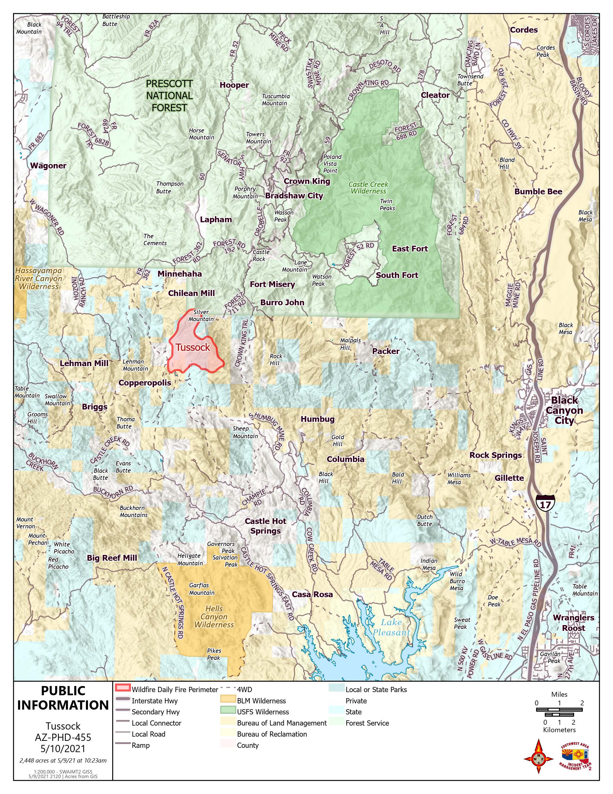
Acres: 5546
Percent Containment: 82%
Date/Time Detected: May 8, 2021. 2:15 PM
Structures burned: 0
Number of Resources: 342
Cause: Human-under investigation Origin/Location: 7 miles southwest of Crown King.
FIREFIGHTERS READY TO SUPPORT ANY NEW FIRE STARTS. RECREATE RESPONSIBLY
FIRE DANGER “EXTREME”
The potential for new wildfires in the southwest is extreme this weekend. Fire officials are preparing for potential dry lightning moving in from New Mexico with high temperatures, single digit humidity, and wind gusts as high as 35 mph. While enjoying our public lands this weekend, please be careful and obey closures and restrictions. You do not want to be responsible for a catastrophic wildfire.
FIRE OPERATIONS
On the Tussock Fire, interior pockets continue to smolder well inside the containment lines. Firefighters continue to build and improve fire containment lines by removing fuel down to mineral soil along the fire’s edge. A “Mop up” method is being used along the fires edge to widen the control buffer by mixing and stirring the hot ashes with water utilizing hand tools. Crews continue to monitor, patrol, and secure the perimeter.
Around the community of Crown King and the Horse Thief Basin area, suppression repair work is being performed where contingency lines were built. Chippers are shredding the cut manzanita and chaparral, then it is spread out to support soil and foliage regeneration.
FIRE RESTRICTIONS
Fire Restrictions are in effect across Arizona. Information is available at http://wildlandfire.az.gov
PUBLIC LAND CLOSURES
All BLM and Prescott National Forest lands, roads, and trails in the area of the Tussock Fire are closed. Full closure details are available on the Tussock Fire Inciweb https://inciweb.nwcg.gov/incident/7472/
Public Information Phone line (8:00 a.m. to 8:00 p.m.): 928-228-0720
Media Information Phone Line: 928-421-4579
Facebook: https://www.facebook.com/TussockFireInfo
Tussock Fire May 16 2021 Morning Update
Related Incident:
Publication Type: News
Tussock Fire– May 16, 2021 Morning Update
Percent Containment: 82%
Structures burned: 0
FIRE DANGER “EXTREME”
FIRE OPERATIONS
FIRE RESTRICTIONS
PUBLIC LAND CLOSURES
Tussock Fire May 15 2021 Morning Update
Related Incident:
Publication Type: News
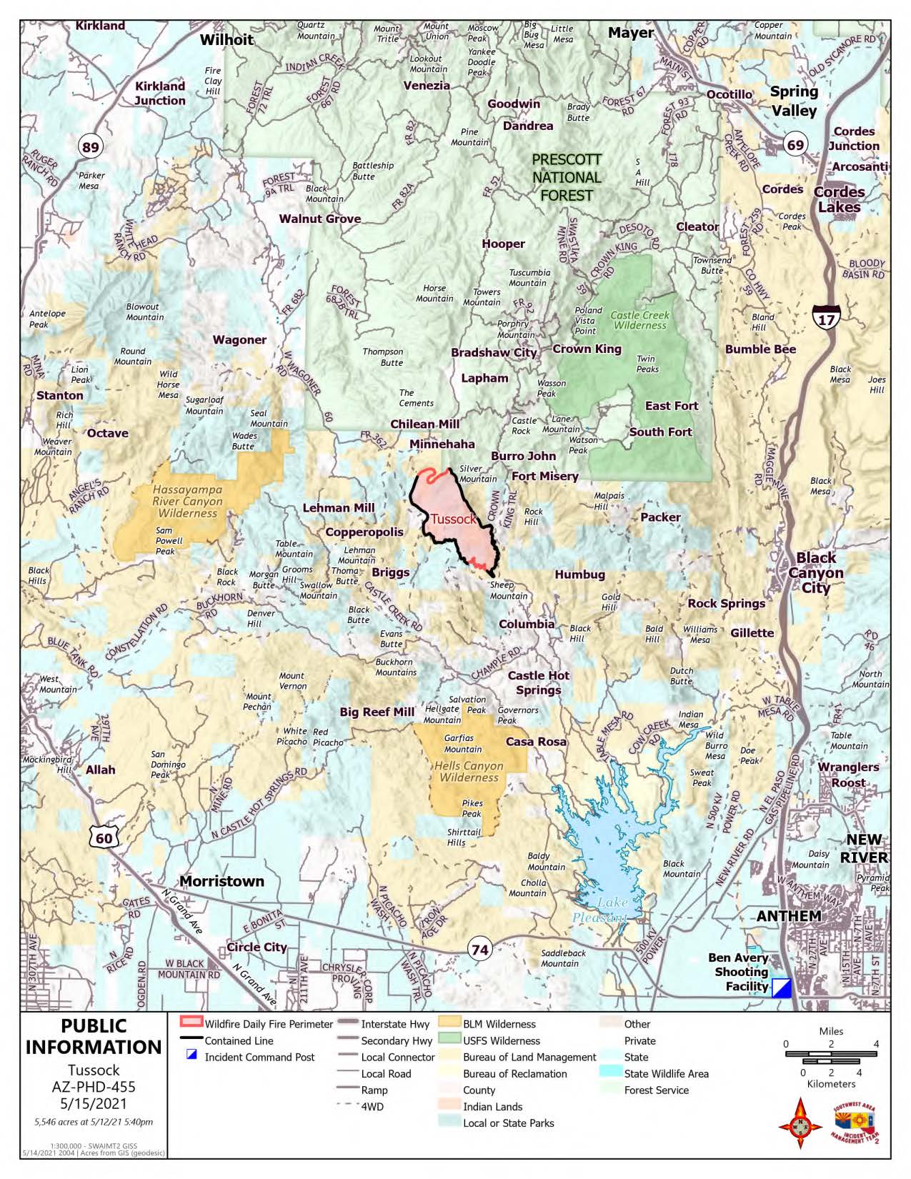
Tussock Fire– May 15, 2021 Morning Update
Acres: 5546
Percent Containment: 74%
Date/Time Detected: May 8, 2021. 2:15 PM
Structures burned: 0
Number of Resources: 419
Cause: Human-under investigation Origin/Location: 7 miles southwest of Crown King.
Weekend Recreationists Encouraged to Practice Fire Safety
Fire Restrictions Across Arizona began yesterday May 14, 2021. Information is available at http://wildlandfire.az.gov
As valley temperatures increase, people are headed to public lands north of Phoenix this weekend. Incident officials are asking that motorists drive slowly and stay out of the fire closure areas. People can prevent human-caused fires by practicing these safety measures:
• Tighten towing chains to not drag on I-17 or any pavement; the chains can easily spark a fire.
• Pull vehicles over where there is no vegetation; vehicle heat can ignite the drought-stricken grasses.
• OHV operators must stay on trails. Vegetation where they ride can easily ignite.
FIRE OPERATIONS
Today no fire movement or growth is expected despite a second day of hot temperatures. The forecast shows low humidity and winds gusting to 40 miles per hours, resulting in critical fire conditions, especially on the ridge of Silver Mountain. Crews are remaining vigilant all around the fire, monitoring, patrolling, and securing the control lines.
The southern fire perimeter has essentially run out of fuels and isolated hot spots are burning themselves out. Up in the northern areas, smoldering isolated hot spots are in steep and rocky areas that are well interior of control lines. They do not pose a hazard to containment. These hot spots should burn out on their own within the next two to three days.
Officials are preparing for potential dry lightning, and firefighters are available for initial attack of new fire starts.
PUBLIC LAND CLOSURES
All BLM and Prescott National Forest lands, roads, and trails in the area of the Tussock Fire are closed. Full closure details are available on the Tussock Fire Inciweb https://inciweb.nwcg.gov/incident/7472/
Public Information Phone line (8:00 a.m. to 8:00 p.m.): 928-228-0720
Media Information Phone Line: 928-421-4579
Facebook: Tussock Fire– May 15, 2021 Morning Update
Acres: 5546
Percent Containment: 74%
Date/Time Detected: May 8, 2021. 2:15 PM
Structures burned: 0
Number of Resources: 419
Cause: Human-under investigation Origin/Location: 7 miles southwest of Crown King.
Weekend Recreationists Encouraged to Practice Fire Safety
Fire Restrictions Across Arizona began yesterday May 14, 2021. Information is available at Tussock Fire– May 15, 2021 Morning Update
Acres: 5546
Percent Containment: 74%
Date/Time Detected: May 8, 2021. 2:15 PM
Structures burned: 0
Number of Resources: 419
Cause: Human-under investigation Origin/Location: 7 miles southwest of Crown King.
Weekend Recreationists Encouraged to Practice Fire Safety
Fire Restrictions Across Arizona began yesterday May 14, 2021. Information is available at http://wildlandfire.az.gov
As valley temperatures increase, people are headed to public lands north of Phoenix this weekend. Incident officials are asking that motorists drive slowly and stay out of the fire closure areas. People can prevent human-caused fires by practicing these safety measures:
• Tighten towing chains to not drag on I-17 or any pavement; the chains can easily spark a fire.
• Pull vehicles over where there is no vegetation; vehicle heat can ignite the drought-stricken grasses.
• OHV operators must stay on trails. Vegetation where they ride can easily ignite.
FIRE OPERATIONS
Today no fire movement or growth is expected despite a second day of hot temperatures. The forecast shows low humidity and winds gusting to 40 miles per hours, resulting in critical fire conditions, especially on the ridge of Silver Mountain. Crews are remaining vigilant all around the fire, monitoring, patrolling, and securing the control lines.
The southern fire perimeter has essentially run out of fuels and isolated hot spots are burning themselves out. Up in the northern areas, smoldering isolated hot spots are in steep and rocky areas that are well interior of control lines. They do not pose a hazard to containment. These hot spots should burn out on their own within the next two to three days.
Officials are preparing for potential dry lightning, and firefighters are available for initial attack of new fire starts.
PUBLIC LAND CLOSURES
All BLM and Prescott National Forest lands, roads, and trails in the area of the Tussock Fire are closed. Full closure details are available on the Tussock Fire Inciweb https://inciweb.nwcg.gov/incident/7472/
Public Information Phone line (8:00 a.m. to 8:00 p.m.): 928-228-0720
Media Information Phone Line: 928-421-4579
Facebook: https://www.facebook.com/TussockFireInfo
Tussock Fire May 14 2021 Morning Update
Related Incident:
Publication Type: News
Tussock Fire– May 14, 2021 Morning Update
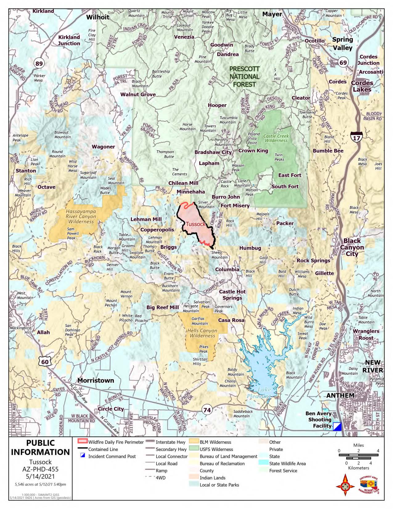
Acres: 5546
Percent Containment: 71%
Date/Time Detected: May 8, 2021. 2:15 PM
Structures burned: 0
Number of Resources: 473
Cause: Human-under investigation Origin/Location: 7 miles southwest of Crown King.
Significant containment achieved in Tussock Fire Evacuations Lifted
FIRE OPERATIONS
Firefighters made significant strides Thursday around most of the Tussock Fire, now at 71% containment. Despite it being the hottest day with little humidity and more winds, all containment lines held well. Pockets of light fuel are burning within the fire’s perimeter producing some smoke. Firefighters are patrolling, monitoring, and securing the fire’s edge. The weather is expected to challenge those containment lines today and tomorrow.
Winds are forecast to pick up, potentially to a Red Flag status and could challenge firefighters working on the north ridgeline. This area is too dangerous to insert crews due to steep terrain. The fire has parked itself there and is being monitored by air. This area has the most potential for fire spread. Heavy equipment continues to build and improve the contingency line and open access if needed.
COMMUNITY MEETING
Incident officials held a virtual Community Meeting on Facebook Thursday night, providing in-depth fire behavior, weather, and operations information. The briefing was recorded and can be seen anytime at https://www.facebook.com/TussockFireInfo
EVACUATIONS LIFTED
The Yavapai County Sheriff's Office lifted evacuations May 13, 2021 for the areas of Fort Misery, Minnehaha, and Horse Thief Basin. All residents in Crown King, Fort Misery, Minnehaha, and Horse Thief Basin should remain in “Ready” Status. Crown King roads remain closed to all non-residents;
https://ein.az.gov/ready-set-go
FIRE RESTRICTIONS
Fire activity and dry conditions trigger Fire Restrictions in Central and Western Arizona Beginning TODAY May 14, 2021. Information is available at: http://wildlandfire.az.gov
PUBLIC LAND CLOSURES:
All BLM and Prescott National Forest lands, roads, and trails in the area of the Tussock Fire are closed. Full closures details are available on the Tussock Fire Inciweb: https://inciweb.nwcg.gov/incident/7472/
Public Information Phone line (8:00 a.m. to 8:00 p.m.): 928-228-0720
Media Information Phone Line: 928-421-4579 Facebook: https://www.facebook.com/TussockFireInfoYCSO Phone Line: (928-771-3260)
Tussock Fire May 13 2021 Morning Update
Related Incident:
Publication Type: News
Tussock Fire– May 13, 2021 Morning Update
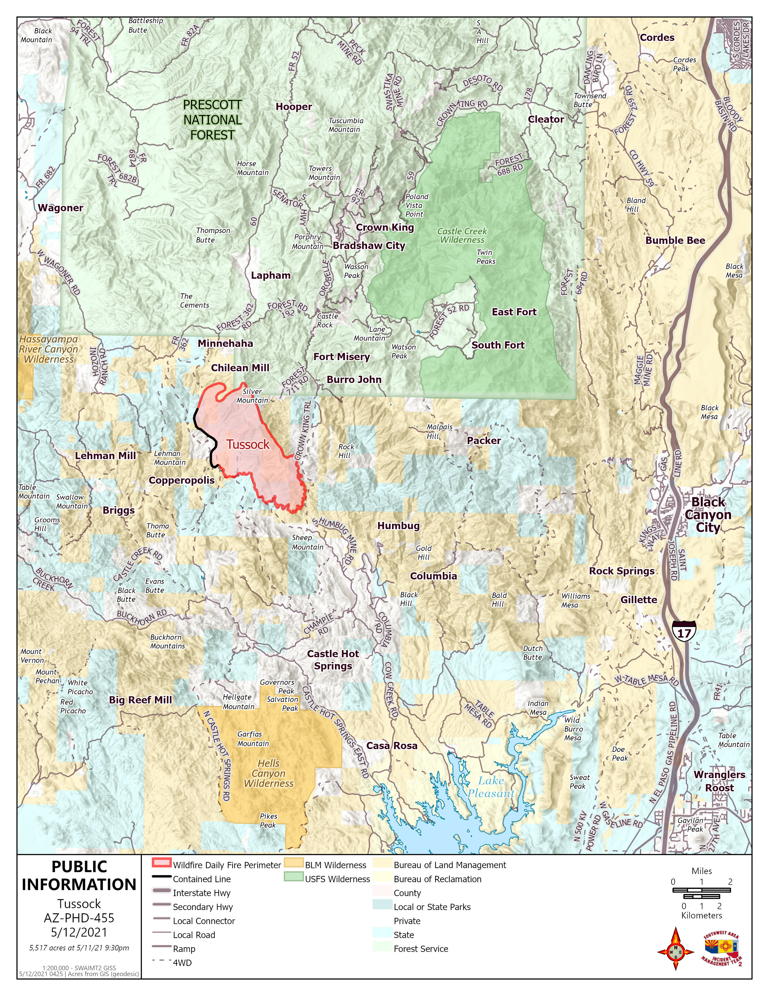
Acres: 5517
Percent Containment: 17%
Date/Time Detected: May 8, 2021. 2:15 PM
Structures burned: 0
Number of Resources: 477
Cause: Human-under investigation
Origin/Location: 7 miles s/w of Crown King.
Community Meeting Tonight (Thursday) 8:00 p.m. Facebook Live
https://www.facebook.com/TussockFireInfo
Southwest Area Incident Management Team 2 will be hosting a virtual Community Meeting Thursday night on Facebook Live at 8:00 p.m. Residents and participants are encouraged to enter questions on the Facebook “chat” or email questions ahead of time to 2021.tussock@firenet.gov.
No Facebook account is required to view the recorded meeting at a later time.
FIRE OPERATIONS: The Tussock Fire was quieter on Wednesday allowing fire personnel to advance containment efforts. Crews continued to make good progress building control lines along the western fire flank and today are moving toward the northern fire edge where the highest potential for fire spread exists. Six Hotshot crews are in place along the rugged eastern flank, building fire control lines and extinguishing hot spots. On the steep northern slopes, heavy equipment is being used to build a fireline in advance of potential spread, essentially a “catcher’s mitt” intended to stop the fire from moving to the north. Equipment and personnel continue to apply structure protection mitigation actions by removing vegetation around the community of Crown King.
EVACUATIONS ORDERED IN THE FOLLOWING AREAS:
Minnehaha, Fort Misery, and Horse Thief Basin are evacuated; however, Crown King remains at SET. Residents should begin preparing in the event an evacuation order is issued. Crown King is closed to non-residents. More information on READY-SET-GO: https://ein.az.gov/ready-set-go
FIRE RESTRICTIONS
Fire Activity and Dry Conditions Trigger Fire Restrictions in Central and Western Arizona
Beginning 8:00 A.M. May 14th, 2021 and continuing until rescinded. The public can obtain current state
and federal fire restrictions information for Arizona at: http://wildlandfire.az.gov
PUBLIC LAND CLOSURES
Public Lands within the BLM Hassayampa Field Office are closed. All Prescott National Forest lands, roads, and trails in the area of the Tussock Fire are closed. Full details of area and road closures are available on the Tussock Fire Inciweb page at: https://inciweb.nwcg.gov/incident/7472/
Public Information Phone Line (8:00 a.m. to 8:00 p.m.): 928-228-0720
Media Information Phone Line: 928-421-4579
Facebook: https://www.facebook.com/TussockFireInfo
YCSO Phone Line: 928-771-3260
Fire Activity and Dry Conditions Trigger Fire Restrictions
Related Incident:
Publication Type: News
NEWS RELEASE http://wildlandfire.az.gov
FOR IMMEDIATE RELEASE
Fire Activity and Dry Conditions Trigger Fire Restrictions in Central and Western Arizona
Phoenix, Ariz. (May 14, 2021) – Effective 8 a.m. Friday, May 14, the Bureau of Land Management (BLM) Phoenix and Colorado River Districts, the Prescott National Forest, the Arizona Department of Forestry and Fire Management, the Tonto National Forest and the Tonto National Monument will implement campfire and smoking restrictions in central and western Arizona. Campfires are never permitted on Imperial, Cibola, Bill Williams River, and Havasu National Wildlife Refuges (NWR); however, campfires are permitted on Kofa NWR unless otherwise restricted. Visitors should check with refuge visitor center for up-to-date information. Residents and visitors should check with respective county governments for information on implementation of fire bans across unincorporated county lands.
Beginning 8 a.m. May 14, 2021, and until rescinded, the following are prohibited:
· Building, maintaining, attending, or using a fire, campfire, charcoal, coal, or wood stove fire, except within a developed recreation site, or improved site.
· Smoking, except within an enclosed vehicle or building. Smoking is prohibited in all federal buildings.
In addition, the BLM Phoenix District, BLM Colorado River District, Prescott National Forest, and the Tonto National Forest will implement the following restriction:
· Discharging a firearm, air rifle or gas gun, except while engaged in a lawful hunt pursuant to state, federal, or tribal law, and regulations.
Fireworks and exploding targets are never allowed on federal and state lands. Target shooting is prohibited year-round on state lands.
Violation of restrictions is punishable by fine, imprisonment or both. Violators may also be held personally responsible for reimbursement of fire suppression costs.
Pressurized liquid or gas stoves, lanterns and heaters possessing shut-off devices are allowed. When using a portable stove, make sure the area is clear of grasses and other fine fuels. Prevent stoves from tipping and starting a fire.
Cigarettes should never be thrown out the window of a vehicle. Instead, ashtrays should be used in order to prevent wildfires. Always practice Leave No Trace principles.
Never park a vehicle over dead grass as the catalytic converter can ignite the vegetation.
Fire conditions as well as localized closures and restrictions are subject to change. Because tribal, federal, state, and local mandates are different, they may have some differences in their restriction notices. For a more detailed explanation concerning agency restrictions and fire information in general, please contact the nearest land management agency office where you plan to work or play or visit http://wildlandfire.az.gov.
Tussock Fire Update revised 512221
Related Incident:
Publication Type: News
Community Meeting Thursday 8:00 p.m. Facebook Live:
https://www.facebook.com/TussockFireInfo
Fire officials ask public to not drive near the Tussock Fire - observe land closures
People should not travel into any of the fire area. More information is on: InciWeb: https://inciweb.nwcg.gov/incident/7472/
Stage 1 Restrictions Are in Effect NOW
Related Incident:
Publication Type: Announcement
Be aware that Stage 1 Fire Restrictions are in effect NOW in Central and Western Arizona Fire Restriction Details
Go to https://www.ycsoaz.gov/ to read the order from the Yavapai Sheriff's Office lifting Tussock Fire related evacuation notice.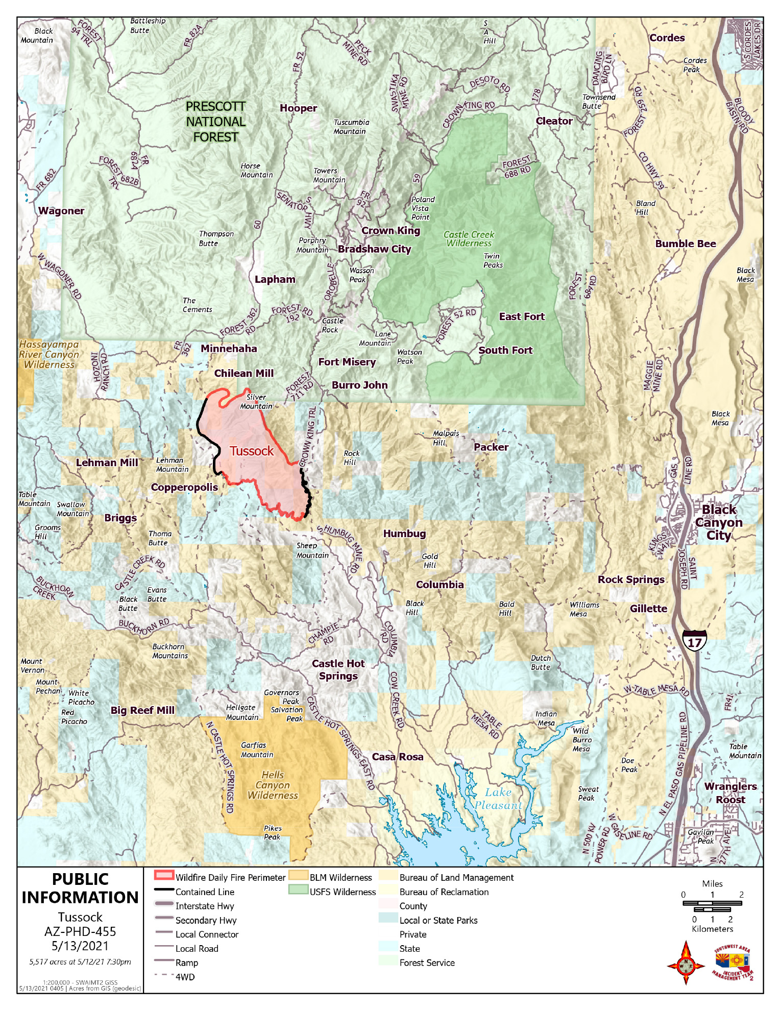
Space Still Available at Mayer High School Evac Center If Needed
Related Incident:
Publication Type: Announcement
For anyone displaced by the Tussock Fire, the Red Cross have shelter available upon request at the Mayer High School Evacuation Center by calling 800-842-7349. The Shelter is unstaffed but space will be made available.