
Fire Restrictions Begin on all BLM Utah Public Lands
Related Incident:
Publication Type: Announcement
FIRE RESTRICTIONS BEGIN FOR ALL BLM UTAH PUBLIC LANDS
Restrictions will help protect public lands, communities, and visitors
SALT LAKE CITY — Beginning June 16 at 12:01 a.m., the Bureau of Land Management (BLM) will implement fire restrictions to prevent losses from human-caused wildfires brought on by extreme drought, high fire danger conditions, and the increased use of public lands in Juab, Millard, Sanpete, Sevier, Wayne and Piute counties. On June 18 at 12:01 a.m., all remaining BLM Utah managed lands will enter restrictions.
These fire restrictions will include multiple measures to help keep public lands safe and accessible as the risk of human-caused wildfires increases. Restrictions will also continue for BLM-managed public lands within Washington, Kane, Garfield, Iron and Beaver counties.
“Given the extreme drought conditions human-caused fires are the biggest threat to public lands right now, which makes using Fire Sense critical to our communities and businesses that rely on public lands,” said BLM Utah State Director Greg Sheehan. “If we use Fire Sense and stop human-caused fires before they start, we can help our communities, we can enjoy public lands, and we can save precious fire fighting resources and water needed to fight those fires. The best way for you to help is to follow the restrictions. You know the fire drill.”
The phrase “you know the fire drill” is central to Utah’s new Fire Sense campaign, focused on common-sense practices to help prevent human-caused wildfires. On May 26, the state of Utah and the BLM launched “Fire Sense” – an interagency fire prevention campaign created to encourage and inform people on how they can change behaviors to prevent wildfires in Utah.
“We realize how dry it is out there and can see how the lack of moisture, combined with the heat and high winds, is a source of potential hazards when it comes to human-caused wildfires. Utah is our home and new fires in Utah are already causing road closures and evacuations,” said BLM Utah State Fire Management Officer Chris Delaney. “We need everyone to use Fire Sense to help prevent devastating consequences to resources and communities. Firefighters have risked their lives on hundreds of preventable, human-caused wildfires this year.”
“A lot of Fire Sense is common sense. Always stay with your campfire and make sure it is out when you are done. Secure your chains and tow straps, so they don’t drag on the ground and cause sparks,” said Canyon Country District Manager Gary Torres.
“We are keeping public lands accessible by using basic Fire Sense. Preventing fires helps prevent damages to the natural resources we use for outdoor recreation activities, like camping, mountain biking and riding OHVs,” said Richfield Field Manager Joelle McCarthy. “If we follow these fire restrictions, we stand a chance, during this drought, at reducing the potential loss of wildlife habitat and forage while managing outdoor recreation.”
Across Utah this year as of mid-June 90% or 294 out of 326 wildfires have been human-caused. Nearly 300 fires could have been prevented and have put firefighters, public lands, and communities in danger. Among the most important restrictions to follow includes campfires. The BLM allows campfires in permanently constructed cement or metal fire pits provided in agency-developed campground and picnic areas. When people use those fire pits, they also need to use some Fire Sense (visit
Recreational target shooters should be aware of current weather and fuel (vegetation) conditions, especially Red Flag Warnings. Use safe ammunition and targets and find an appropriate backdrop void of rocks and vegetation. Have a shovel and water or a fire extinguisher and only shoot in areas where legally allowed.
Restrictions include:
- No campfires using charcoal, solid fuel or any ash-producing fuel, except in permanently constructed cement or metal fire pits located in agency-developed campgrounds and picnic areas. Examples of solid fuels include but are not limited to wood, charcoal, peat, coal, Hexamine fuel tablets, wood pellets, corn, wheat, rye, and other grains.
- No grinding, cutting and welding of metal.
- No smoking except within an enclosed vehicle, covered areas, developed recreation site or while stopped in a cleared area of at least three feet in diameter (10 feet in areas managed by the Moab and Monticello field offices) that is barren with no flammable vegetation.
- No operating or using any internal or external combustion engine without a spark arresting device properly installed, maintained and in effective working order as determined by the Society of Automotive Engineers (SAE) recommended practices J335 and J350. Refer to Title 43 CFR 8343.1.
- The non-commercial use/discharge of explosives of any kind, incendiary or chemical devices, pyrotechnic devices, exploding targets, pressurized containers or canisters, and binary explosives.
- The use/discharge of any kind of fireworks as defined by this order.
The BLM fire prevention orders that outline fire restrictions can also be found at https://utahfireinfo.gov/active-fire-restriction-documents/ or at https://go.usa.gov/xGnDx. Restrictions of specific activities will remain in place until human caused fires and fire dangers decrease.
On May 18, the Utah State Director signed a Fire Prevention Order, which can be found at the BLM Utah Fire and Aviation webpage: https://www.blm.gov/programs/public-safety-and-fire/fire-and-aviation/regional-info/utah and the Utah Fire Info webpage: https://utahfireinfo.gov/.
For more information on preventing unwanted human caused wildfires, visit www.utahfireinfo.gov or on Twitter
Statewide Fireworks Restrictions
Related Incident:
Publication Type: Announcement
The complete Fire Restriction Order may be found under "Related Information" below.
Fire Restriction Order Due to current and forecasted weather conditions coupled with the dry conditions and extreme fire danger throughout Utah, the State Forester has determined that measures must be taken to prevent the ignition of forest and rangeland fires. Therefore, pursuant to Utah State Law, Section 65A-8-212, the following acts are prohibited in the areas described below until rescinded by the Utah State Forester:
1. Discharging or using any kind of fireworks
Area Description:
All state-owned lands -AND- all unincorporated private lands within the state of Utah.
The following persons are exempted from the above prohibitions:
1. Persons with a “Display Operator” license issued by the Utah State Fire Marshal’s Office AND any local permits required where the display is to take place.
Effective Date: 12:01 a.m., Wednesday, June 9, 2021
Statewide Fire Restrictions
Related Incident:
Publication Type: Announcement
The complete Fire Restriction Order may be found under "Related Information" below.
Fire Restriction Order
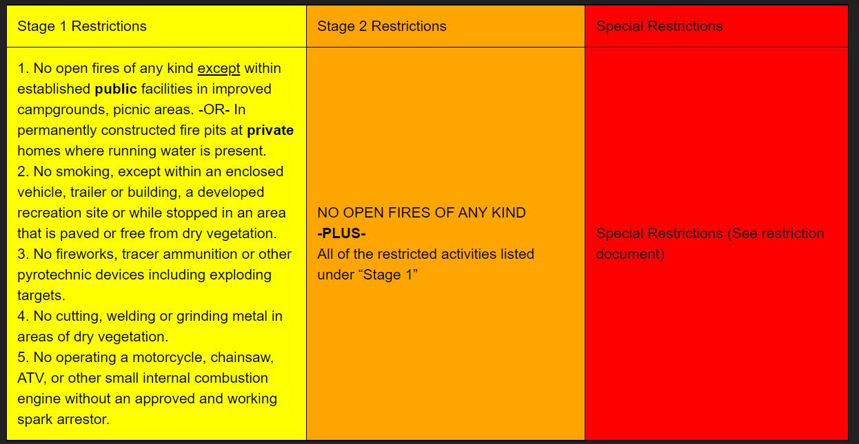
Due to current and forecasted weather conditions coupled with the record dry vegetation conditions and extreme fire danger throughout Utah, the State Forester has determined that measures must be taken to prevent the ignition of forest and rangeland fires. Therefore, pursuant to Utah State Law, Section 65A-8-212, the following acts (also known as “Stage 1 Fire Restrictions) are prohibited in the areas described below until rescinded by the Utah State Forester:
1. No open fires of any kind except within established facilities in improved campgrounds or day-use areas on public lands. -OR- In permanently constructed fire pits at permanent private dwellings served by pressurized running water.
2. Smoking, except within an enclosed vehicle, trailer or building, a developed recreation site or while stopped in an area that is paved or free from dry vegetation.
3. Cutting, welding or grinding metal in areas of dry vegetation.
4. Operating a motorcycle, chainsaw, ATV, or other small internal combustion engine without an approved and working spark arrestor.
Area Description: All state lands –AND- all unincorporated private lands within the state of Utah. This order does not affect private lands within incorporated towns or city limits. The following persons are exempted from the above prohibitions:
1. Persons with a permit or waiver issued by the Division, specifically authorizing a specified act at a specific location. A waiver does not relieve the permittee of liability if a fire does occur.
2. Any on-duty firefighter in the performance of an official duty.
Any of the above acts is a violation of state law and is punishable by up to 6 months in jail and a fine of up to $1,000. These restrictions will be enforced by county law enforcement.
Effective Date: 12:01 a.m., on the 10th day of June, 2021
Smoke Outlook for 616 617 NE Utah Bear Bennion Creek Fires
Related Incident:
Publication Type: News
Special Statement
Red Flag Warning in effect today until 10PM Thursday.
Fire
Currently the Bear fire is at 11,225 acres and 30% contained and the Bennion fire is at 8,325 acres and 17% contained. Crews continue to make good progress on both fires whichresulted in no new starts with minimal smoke production throughout the evening. Today we will see a wind shift and possible dry lightning which could result in new starts and an increase in fire behavior which will result in more smoke production.
Smoke
Winds are predicted to change from SW to NW leading to more smoke being blown into the Helper area and Price area with good moderate air quality throughout the day. Moab will seelingering smoke from the Pack Creek fire and will be in the good to moderate ranges throughout the day. Communities North and East of the fire should see less smoke into the day and then increase in the evening and morning hours.
Other
The following groups are considered sensitive when it comes to air quality; - Children, mostly because their lungs are still developing. - Anyone with specific preexisting conditions suchas asthma, COPD or heart disease. - Pregnant women. Check the most current air quality at airnow.gov
Bear and Bennion Creek Fires Story Map
Related Incident:
Publication Type: Announcement
An interactive story map featuring information on fire fighting efforts associated with the Bear and Bennion Creek Fires is now available. The story map can be viewed on computers or mobile devices, but works better on a larger screened device (like a laptop or desktop computer). Visit: https://arcg.is/1Ca5jb
Bear Fire June 14 Morning Update
Related Incident:
Publication Type: News
Favorable conditions allowed firefighters to get good work done overnight, including cleaning up line along Ford Ridge. The fire burned actively all night, but all activity was internal to proposed containment lines. It was especially visible north of Helper, on Hardscrabble Canyon and Spring Canyon roads.
Bear Fire June 13 Morning Update
Related Incident:
Publication Type: News
The Bear Fire is currently mapped at 10,526 acres and is approximately 10% contained.
A Red Flag Warning is in effect for the fire area today for high temperatures and increased winds.
###
Pack Creek Fire Update July 6
Related Incident:
Publication Type: News
Pack Creek Fire Update
Tuesday, July 6, 2021
U.S. District Office Front Desk: 435- 259-7155
Forest Service Media Contact: Samantha Stoffregen 435-299-9164
Visit www.utahfireinfo.gov
Cause: Abandoned campfire
Size in Acres: 8,952
Percent Contained: 100
Helicopters: 0
Wildfire Modules: 2
Crews: 0
Total Personnel: 46
Summary:
The Pack Creek Fire is 100% contained. Even though the fire is contained, it continues to burn in the interior. Firefighters continue monitoring the fire, looking for hotspots along the perimeter, addressing hazards, and completing rehabilitation work. Firefighters are working most heavily in Geyser Pass and north of Haystack Mountain. Due to decreased resource needs and incident complexity, the Type 3 Incident Management Team is transitioning to the Type 4 Incident Management Team led by Kathryn Sebes from the Fish and Wildlife Service. This will be the final update unless conditions change.
Please respect private property and the privacy of area residents. Refrain from stopping in the Pack Creek Community. The residents of Pack Creek continue to recover from the impacts of the fire.
The fire managers would like to express their thanks to the community for all of their support. The team would also like to thank the responding fire departments including the Blanding Volunteer Fire Department, Green River Fire Department, La Sal Volunteer Fire Department, Moab Valley Volunteer Fire Department, Monticello Volunteer Fire Department, and Thompson Springs Volunteer Fire Department as well as our local partners including Grand and San Juan County Sheriffs and their departments, Grand County EMS, Rocky Mountain Power, local government entities, Grand County Water and Sewer, and others from around the state who supported firefighting efforts. Your contributions were invaluable.
Conditions:
While fire activity is minimal, the fire continues to burn in the interior and, as conditions dry out, Moab residents and visitors may continue to see smoke throughout the summer. Spot fires will likely cause isolated smoke columns and continue to burn in the areas closed to public access. These small fires have a low likelihood of spreading and will help clean out light fuels from the forest understory.
Evacuations Lifted:
As of today Tuesday, July 6, 2021, all remaining private property evacuation orders associated with the Pack Creek Fire have been lifted by the San Juan County Sheriff. This includes private property in and around the area east of Geyser Pass on La Sal Mountains, from Blue Lake down through Dark Canyon Area. However Geyser pass road from Trans La Sal Trailhead on the west side of the closure and to the upper geyser pass trailhead (Whole Enchilada) on the east side of the closure will be closed. All of the Oowah Lake road will remain gated, locked and closed. Oowah campground will be closed.
Forest Closure:
The forest closure for parts of the western slope of the La Sal Mountains is still in effect. We appreciate the continued support from the public and ask that you continue to stay out of the area for firefighter and public safety. The Manti-La Sal National Forest is planning to update the closure for National Forest lands to allow for increased access. When available, the updated forest information will be posted on the Manti-La Sal Forest website at: www.fs.usda.gov/mantilasal.
Soil Burn Severity Map:
Burned Area Emergency Response (BAER) team finalized the Soil Burn Severity map for the Pack Creek Fire. The soil burn severity is categorized by 4 levels: unburned, low, moderate, and high. BAER soil scientists used satellite images to prioritize places in the field to assess soil burn severity. The team sampled sites to evaluate soil changes caused by the fire. They collected information on ground cover, canopy consumption, intact roots, and water repellency to better understand soil burn severity. The analysis showed soil burn severity (noted in acres):
Unburned: 820 acres (9%)
Low: 3,722 (40%)
Moderate: 4,586 (49%)
High: 151 (2%)
BAER post-fire assessment teams use the soil burn severity data to identify risks to human life and safety, property, and critical natural and cultural resources from increased soil erosion, accelerated surface water run-off, and debris flows. This information helps the BAER team determine areas where potential emergency stabilization treatments may be needed to reduce risk.
The team prepared the attached Soil Burn Severity map. The Soil Burn Severity map isn’t an erosion risk map, but does help define areas where potential increases in the rates of erosion and run-off are expected from steep hillslopes with high and moderate soil burn severity. Areas located downstream from moderate and high soil burn severity may experience increased rates of erosion, debris flows, and surface run-off following short-duration, high-intensity rainfall events.
Other Information:
The Temporary Flight Restriction (TFR) over the fire area has been lifted and normal flight operations in the area can resume.
Investigators are still seeking leads to help identify those responsible for the fire’s ignition. Anyone who has information related to the identification of the responsible party of the Pack Creek Fire can call the tip line at 775-355-5337.
As of June 25, public and state lands are in stage 2 fire restrictions in Carbon, Emery, Grand and San Juan counties. Stage 2 restrictions mean campfires are not allowed on public or state lands. Learn more on the Utah Fire Information website: https://utahfireinfo.gov/active-fire-restriction-documents/.
Pack Creek Fire Update July 1
Related Incident:
Publication Type: News
Pack Creek Fire Update
Thursday, July 1, 2021
Fire Information: (435) 287-4126 or rwootton@blm.gov
Visit www.utahfireinfo.gov or our storymap at https://arcg.is/SH4Hm0
Cause: Abandoned campfire
Size in Acres: 8,952
Percent Contained: 85%
Helicopters: 1
Engines: 4
Crews: 0
Total Personnel: 55
Summary:
Due to decreased fire activity and high containment, this will be the last daily update for the Pack Creek Fire unless conditions change. We will continue to share major developments on social media, the Utah Fire Info website, Inciweb, as needed.
Firefighters continue monitoring the fire, looking for hotspots along the perimeter, addressing hazards, and completing rehabilitation work. Moisture in the mountains continues to aid suppression efforts. Thunderstorms are expected to continue through early next week. Even though fire activity is minimal, the fire is still burning in the interior and, as conditions dry out, Moab residents and visitors may continue to see smoke throughout the summer.
The Temporary Flight Restriction (TFR) has been updated and now includes a fire mile radius over the fire. Unauthorized use of aircraft (including drones) in a TFR is illegal and is a safety risk for firefighters and pilots.
Evacuations are still in place for the Holyoak and Dark Canyon areas. Fire managers anticipate that the evacuation order will be lifted next week, but some forest areas will likely remain closed throughout the summer. The La Sal Loop Road is now open, but Geyser Pass and Oowah Lake Roads are closed. The Warner Lake and Oowah Lake campgrounds remain closed.
The Manti La Sal National Forest updated the closure order for the La Sal Mountains on June 24. The updated closure is still in effect, but as people begin to re-enter the area, they should be on the lookout for fallen trees, uneven ground, reduced visibility from dust or smoke, firefighting personnel who continue to work in the area, and other hazards. The public should expect trail and recreation site closures to continue due to risks from falling trees and/or potential flooding. The closure can be found online: https://bit.ly/3h7ixYM.
Investigators are still seeking leads to help identify those responsible for the fire’s ignition. Anyone who has information related to the identification of the responsible party of the Pack Creek Fire can call the tip line at 775-355-5337.
As of June 25, public and state lands are in stage 2 fire restrictions in Carbon, Emery, Grand and San Juan counties. Stage 2 restrictions mean campfires are not allowed on public or state lands. Learn more on the Utah Fire Information website: https://utahfireinfo.gov/active-fire-restriction-documents/.
Pack Creek Fire Update June 30
Related Incident:
Publication Type: News
Pack Creek Fire Update
Wednesday, June 30, 2021
Fire Information: (435) 287-4126 or rwootton@blm.gov
Visit www.utahfireinfo.gov or our storymap at https://arcg.is/SH4Hm0
Cause: Abandoned campfire
Size in Acres: 8,952
Percent Contained: 85%
Helicopters: 1
Engines: 4
Crews: 0
Total Personnel: 55
Summary:
Firefighters continue monitoring the fire, looking for hotspots along the perimeter, addressing hazards, and completing rehabilitation work. Fire behavior is expected to remain minimal. Light rains over most of the fire area in the last 24 hours have helped to decrease fire activity and integrate ash into the soil. We expect humidity, wind, and moisture in the area throughout the week.
Even though fire activity is minimal, the fire is still burning in the interior and, as conditions dry out, Moab residents and visitors may continue to see smoke throughout the summer.
The Temporary Flight Restriction (TFR) has been updated and now includes a fire mile radius over the fire. Unauthorized use of aircraft (including drones) in a TFR is illegal and is a safety risk for firefighters and pilots.
Evacuations are still in place for the Holyoak and Dark Canyon areas. The La Sal Loop Road is now open, but Geyser Pass and Oowah Lake Roads are closed. The Warner Lake and Oowah Lake campgrounds remain closed. The Manti La Sal National Forest updated the closure order for the La Sal Mountains on June 24. The updated closure is still in effect, but as people begin to re-enter the area, they should be on the lookout for fallen trees, uneven ground, reduced visibility from dust or smoke, firefighting personnel who continue to work in the area, and other hazards. The public should expect trail and recreation site closures to continue due to risks from falling trees and/or potential flooding. The closure can be found online: https://bit.ly/3h7ixYM.
Investigators are still seeking leads to help identify those responsible for the fire’s ignition. Anyone who has information related to the identification of the responsible party of the Pack Creek Fire can call the tip line at 775-355-5337.
As of June 25, public and state lands are in stage 2 fire restrictions in Carbon, Emery, Grand and San Juan counties. Stage 2 restrictions mean campfires are not allowed on public or state lands. Learn more on the Utah Fire Information website: https://utahfireinfo.gov/active-fire-restriction-documents/.