
Hermits Peak and Calf Canyon Fires Daily Update 9 am May 6
Related Incident: Hermits Peak Fire
Publication Type: News
Acres: 168,009 acres
Containment: 20%
Total personnel: 1,374
Start Date: Hermits Peak: April 6, 2022; Calf Canyon: April 19, 2022
Cause: Hermits Peak: spot fires from prescribed burn; Calf Canyon: under investigation
Location: Located near Gallinas Canyon
Fuels: Heavy mixed conifer, ponderosa pine, brush, and grass
Highlights: With a major wind event expected to begin Saturday and last for several days, firefighters are taking advantage of the current favorable weather to get additional containment line around the fire perimeter and contingency lines constructed further out. This includes putting in more dozer line and handline, doing firing operations to clear fuels, and tying together existing lines. Six structure protection groups with over 300 firefighters are working in communities around the fire. They are identifying homes and other values, removing fuels, setting up sprinkler systems, and putting in fire line to fortify structures. Moderated winds allowed for more air support the last few days to aid ground operations. The upcoming wind event is predicted to be historic due to the duration and the area it will impact. It is critical that people continue to watch for changes in evacuation status and pay attention to emergency notifications.
Operations: Fire crews made a lot of progress yesterday, continuing to strengthen and widen lines around the fire and putting additional structure protections in place. On the east side the black line continues to hold, and crews are monitoring the area around Las Tusas and the sawmill and working to protect them from further impacts. Firefighters were able to go direct in the area around the United World College and reduce the threat significantly. North of NM Highway 283 near Las Vegas, firefighters are tying in constructed line to “cold black” areas already burned and now cooled, bolstering containment lines. On the southwest perimeter, firefighters are working to open roads and construct dozer line. The fire has been active in the Mineral Hills area, but light winds have allowed aerial resources to conduct retardant and water drops to assist firefighters on the ground. Heavy ground and air resources are in the area, including structure crews working to protect homes and values. In the wilderness, crews have been scouting for trails, natural features, and wet areas to tie together to keep fire from moving further west. On the northwestern side, equipment operators are improving dozer lines and crews are helping check the fires edge. Lots of resources are in this area and on the north side helping to put additional fire containment measures in place. Structure protection groups are working up NM Highways 518, 434, and 442. Crews are also monitoring the areas around Ledoux and Pacheco Village to address any remaining issues.
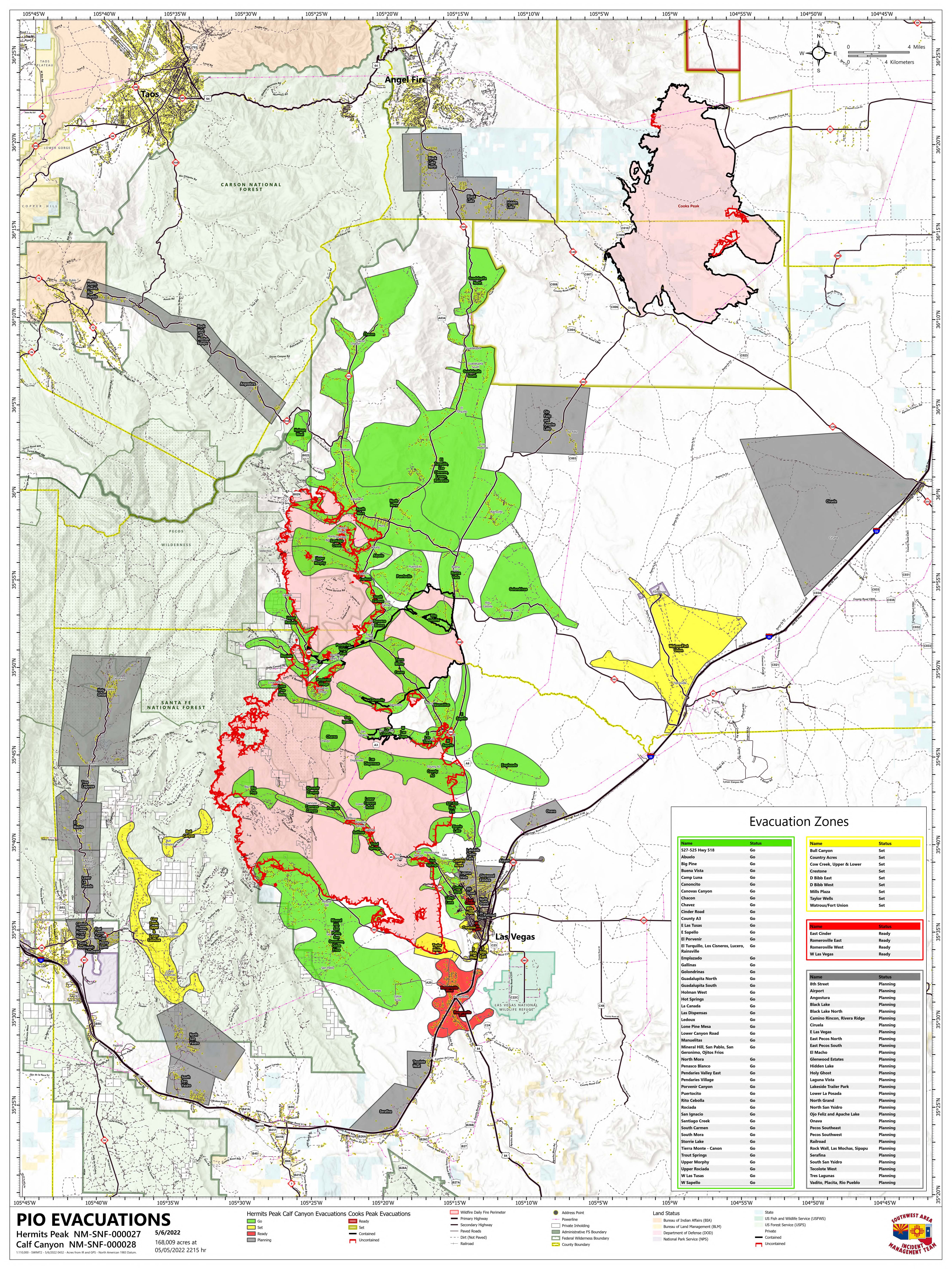
Evacuations: Scan the QR code here for the latest evacuation map or visit the ArcGIS Map. The San Miguel and Mora County Sheriffs ask that all residents within the fire area remain on high alert for changes to evacuation statuses and road closures. It is imperative to respect closures and follow evacuation orders. Please follow San Miguel County and Mora County Sheriff’s Facebook pages for the latest updates at https://www.facebook.com/smcso.nm and https://www.facebook.com/moracountysheriffoffice.
Weather: West to northwest winds of 10 to 15 mph in the morning will increase to 15 to 20 mph in the afternoon. Wind gusts will be around 30 to 35 mph. Maximum temperatures will be in the upper 70’s to lower 80’s. Minimum relative humidity values will be 6 to 12%.
Restrictions: The Santa Fe National Forest has expanded the closure order due to the fire to include the entire Pecos/Las Vegas Ranger District and has implemented forest-wide Stage 2 fire restrictions. Full closure order and map are available at www.fs.usda.gov/detail/santafe/alerts-notices/?cid=stelprd3802009.Smoke: An interactive smoke map at https://fire.airnow.gov/ allows you to zoom into your area to see the latest smoke conditions.
Future Fire Information: The Hermits Peak and Calf Canyon Fires Information office hours are 8:00 AM – 8:00 PM. The phone number for fire information is 505-356-2636. The email address is 2022.hermitspeak@firenet.gov. Future fire information will continue to be posted on Inciweb, the SFNF Facebook and Twitter, SFNF website, and New Mexico Fire Information website.
Hermits Peak and Calf Canyon Fires Daily Update 7 am May 5
Related Incident: Hermits Peak Fire
Publication Type: News
Acres: 165,276 acres - Containment: 20% - Total personnel: 1,284
Start Date: Hermits Peak: April 6, 2022; Calf Canyon: April 19, 2022
Cause: Hermits Peak: spot fires from prescribed burn; Calf Canyon: under investigation
Location: Located near Gallinas Canyon - Fuels: Heavy mixed conifer, ponderosa pine, brush, and grass
Highlights: Fire resources made good progress constructing line and performing structure protection around the fire yesterday. Efforts continue to secure containment lines ahead of high temperatures and winds this weekend. Please respect all closures and allow firefighting resources to work safely. Firefighter and public safety will continue to be the number one priority.
Operations: Air resources, hand crews and heavy equipment had good success holding dozer line along the west side of the City of Las Vegas and NM Highway 283 yesterday. The primary focus of firefighting efforts will be containment line construction around the perimeter of the fire, as well as structure protection throughout the fire area. A two-day window of more favorable weather will give firefighters a chance to take proactive measures ahead of elevated temperatures and high winds predicted for this weekend. Today on the eastern flank of the fire, construction will continue on dozer line east of NM Highway 518 to catch the fire in the event that winds this weekend push the fire across the highway. On the north end of the fire, two structure protection groups are engaged in communities as crews and equipment reinforce line north of Mora and Cleveland, up to Holman, to prevent further fire growth in that direction. On the south/ southeast edge of the fire, structure protection measures will be in place around homes and communities that are still under threat, including Mineral Hill and the surrounding neighborhoods. Crews and heavy equipment continue to strengthen and hold containment lines along the west side of the City of Las Vegas and HWY 283. Structure protection resources are imbedded in communities where there is still active fire along the western flank as crews work to establish containment line to prevent further spread to the west. Continuous air operations, both fixed wing and helicopter, will support work on the ground in most divisions while the weather remains favorable for flying.
Evacuations: Scan the QR code here for the latest evacuation map or visit the ArcGIS Map. The San Miguel and Mora County Sheriffs ask that all residents within the fire area remain on high alert for changes to evacuation statuses and road closures. It is imperative to respect closures and follow evacuation orders. Please follow San Miguel County and Mora County Sheriff’s Facebook pages for the latest updates at https://www.facebook.com/smcso.nm andhttps://www.facebook.com/moracountysheriffoffice.
Weather: West to northwest winds of 10 to 15 mph in the morning will increase to 15 to 20 mph in the afternoon. Wind gusts will be around 30 mph. Maximum temperatures will top out from around 60 degrees to the lower 70s. Minimum relative humidity values will be 7 to 13%.
Restrictions: The Santa Fe National Forest has expanded the closure order due to the fire to include the entire Pecos/Las Vegas Ranger District and has implemented forest-wide Stage 2 fire restrictions. Full closure order and map are available atwww.fs.usda.gov/detail/santafe/alerts-notices/?cid=stelprd3802009.
Smoke: An interactive smoke map at https://fire.airnow.gov/ allows you to zoom into your area to see the latest smoke conditions.
Future Fire Information: The Hermits Peak and Calf Canyon Fires Information office hours are 8:00 AM – 8:00 PM. The phone number for fire information is 505-356-2636. The email address is 2022.calfcanyon@firenet.gov. Future fire information will continue to be posted on Inciweb, the SFNF Facebook and Twitter, SFNF website, and New Mexico Fire Information website.
Hermits Peak and Calf Canyon Fires Daily Update 9 am May 4
Related Incident: Hermits Peak Fire
Publication Type: News
Hermits Peak and Calf Canyon FiresMay 4, 2022, Daily Update, 09:00AM
Highlights: A steady aerial assault on the fire yesterday provided opportunity for firefighters to engage aggressively on the ground. Structure protection, line construction and firing operations will continue today. Please respect all closures and allow firefighting resources to work safely. Firefighter and public safety will continue to be the number one priority.
Operations: Firefighters continued defensive firing operations yesterday to remove fuels near structures and secure line. Air resources flew all day in support of these missions. There is an anticipated increase in fire activity in multiple locations across the fire as winds shift throughout the day. Six Structure Groups across the fire will focus efforts on removing fuels, constructing line and deploying other protection measures around homes and communities. Structure Groups are populated with protection resources in every division of the fire. These resources will be working anywhere that homes, cabins and other values at risk are threatened, moving between areas of increased fire activity throughout the day. Crews will continue firing operations, removing fuel between containment lines and the uncontrolled fire front to slow fire spread. Numerous helicopters, LATs (Large Air Tankers) and VLATs (Very Large Air Tankers), as well as six scooper planes continue to deliver water and retardant to the fireline. As a reminder, the scooper planes are dipping water out of Lake Isabel which is on private property. No public is allowed in this area. The Temporary Flight Restriction (TFR) zone in place over the fire area was expanded to include the City of Las Vegas and the Las Vegas airport. The zone also restricts the flight of unmanned aircraft, or drones. If a private drone intrudes into the fire area, it will require a pause in all air operations and impede firefighting progress, putting firefighters at greater risk.
Evacuations: Scan the QR code here for the latest evacuation map or visit the ArcGIS Map. The San Miguel and Mora County Sheriffs ask that all residents within the fire area remain on high alert for changes to evacuation statuses and road closures. It is imperative to respect closures and follow evacuation orders. Please follow San Miguel County and Mora County Sheriff’s Facebook pages for the latest updates at https://www.facebook.com/smcso.nm and https://www.facebook.com/moracountysheriffoffice.
Weather: A Red Flag Warning is in effect from 10:00 am to 9:00 pm. Southwest to west winds in the morning of 15 to 20 mph will become west to northwest at 22 to 27 mph in the afternoon. Wind gusts will be between 35 and 40 mph. Maximum temperatures will top out in the lower 50s to mid 60s. Minimum relative humidity values will be 8 to 15 %.
Restrictions: The Santa Fe National Forest has expanded the closure order due to the fire to include the entire Pecos/Las Vegas Ranger District and has implemented forest-wide Stage 2 fire restrictions. Full closure order and map are available at www.fs.usda.gov/detail/santafe/alerts-notices/?cid=stelprd3802009.
Smoke: Communities on the east and immediate south sides of the fire will see the greatest reduction in air quality. The Las Vegas Valley will see Unhealthy for Sensitive Groups (USG) today becoming Unhealthy into tonight. Mora will average USG with periods of Unhealthy late afternoon into tonight with winds pushing smoke eastward. Air quality around Rociada, Pendaries and Buena Vista should improve somewhat by late afternoon with cleaner west to northwest wind. The NM Highway 518 corridor will generally have USG to periods of Unhealthy into tonight. An interactive smoke map at https://fire.airnow.gov/ allows you to zoom into your area to see the latest smoke conditions.
Future Fire Information: The Calf Canyon Fire and Hermit Peak Fire Information office hours are 8:00 AM – 8:00 PM. The phone number for fire information is 505-356-2636. The email address is 2022.calfcanyon@firenet.gov. Future fire information will continue to be posted on Inciweb, the SFNF Facebook and Twitter, SFNF website, and New Mexico Fire Information website.
Hermits Peak and Calf Canyon Fires Daily Update 9 am May 3
Related Incident: Hermits Peak Fire
Publication Type: News
Hermits Peak and Calf Canyon
May 3, 2022, Daily Update, 09:00 AM
Acres: 145,854 acres - Containment: 20% - Total personnel: 1,085
Start Date: Hermits Peak: April 6, 2022; Calf Canyon: April 19, 2022
Cause: Hermits Peak: spot fires from prescribed burn; Calf Canyon: under investigation
Location: Located near Gallinas Canyon - Fuels: Heavy mixed conifer, ponderosa pine, brush, and grass
Operations: Winds were calmer than expected yesterday, providing an opportunity for firefighters to engage in suppression tactics in anticipation of less favorable weather ahead. Two very large air tankers (VLAT) were loaned to the fire to deliver massive loads of retardant to the fire line. Firing operations were performed to widen holding lines and remove fuels ahead of a wind shift that could threaten communities. Structure protection resources will be removing fuels around structures and securing lines around populated areas. Fire moving against the wind is expected in some areas, also referred to as a backing fire, giving firefighters a chance to limit fire spread at roads and constructed lines. Resources will be bolstered in areas with the most anticipated fire activity and the highest probability of success in protecting homes and other values at risk. Air resources will continue to operate as conditions allow. A strike team of mutual aid structure engines requested by San Miguel County and the City of Las Vegas will be working in cooperation with the team to provide protection for the city.
Evacuations: Scan the QR code here for the latest evacuation map or visit the ArcGIS Map. The San Miguel and Mora County Sheriffs ask that all residents within the fire area remain on high alert for changes to evacuation statuses and road closures. It is imperative to respect closures and follow evacuation orders. Please follow San Miguel County and Mora County Sheriff’s Facebook pages for the latest updates at https://www.facebook.com/smcso.nm and https://www.facebook.com/moracountysheriffoffice.
Weather: There is a red flag warning in effect 12:00 pm to 9:00 pm. High temperatures will be mid 60s to mid 70s, maximum wind speeds 25-30 with gusts to 45 mph. Winds will be out of the south-southeast, shifting to south-southwest later this evening.
Restrictions: The Santa Fe National Forest has expanded the closure order due to the fire to include the entire Pecos/Las Vegas Ranger District and has implemented forest-wide Stage 2 fire restrictions. Full closure order and map are available at www.fs.usda.gov/detail/santafe/alerts-notices/?cid=stelprd3802009. There is a temporary flight restriction (TFR) in place over the area. The TFR also covers unmanned aircraft, or drones. If a private drone intrudes into the fire area, it will require a pause in all air operations and impede firefighting progress, putting firefighters at greater risk.
Smoke: An interactive smoke map at https://fire.airnow.gov/ allows you to zoom into your area to see the latest smoke conditions.
Future Fire Information: The Calf Canyon Fire and Hermit Peak Fire Information office hours are 8:00 AM – 8:00 PM. The phone number for fire information is 505-356-2636. The email address is 2022.calfcanyon@firenet.gov. Future fire information will continue to be posted on Inciweb, the SFNF Facebook and Twitter, SFNF website, and New Mexico Fire Information website.
Calf Canyon and Hermits Peak Fires Daily Update 9 am May 2
Related Incident: Hermits Peak Fire
Publication Type: News
Calf Canyon and Hermits Peak Fires
May 2, 2022, Daily Update, 09:00 AM
Acres: 120,653 acres
Containment: 20%
Start Date: April 19, 2022
Cause: Under investigation
Total Personnel: 1,052
Fuels: Mixed conifer
Highlights: Changing winds pushed the fire north toward Mora and northwest toward Las Tusas and Sapello yesterday. Overnight, the fire moved south toward Las Vegas. A red flag warning is in effect today. Evacuation levels continue to change rapidly, please remain vigilant and scan the QR code below for an updated map. Respect all closures and allow firefighting resources to work safely. Firefighter and public safety will continue to be the number one priority.
Operations: The fire made a significant run to the north yesterday, driven by winds out of the south/southwest. Lines were challenged northward of Ledoux towards Mora. An additional push on the eastern edge moved the fire towards Las Tusas and Sapello. Overnight, shifting winds moved the fire southeast toward Las Vegas. Additional resources from local jurisdictions were called in to support the firefight late yesterday and overnight. New evacuations are in place around the fire perimeter. Please scan the QR code to see real-time evacuation updates. Today, crews remain engaged in structure protection in four groups across the fire, constructing line, and reinforcing existing roads and natural features as holding points. Protecting homes, water sources and other values at risk will continue to be the focus of fire resources on all divisions of the fire. Air operations will continue until high winds require pilots to set down. Please remember that drones are still prohibited in the temporary flight restriction zone, outlined on the map. If drones enter the flight zone, firefighting aircraft will be immediately grounded, eliminating a much-needed resource.
Evacuations: Scan the QR code here for the latest evacuation map. The San Miguel and Mora County Sheriffs ask that all residents within the fire area remain on high alert for changes to evacuation statuses and road closures. It is imperative to respect closures and follow evacuation orders. Failure to do so can pose additional risk to firefighters and the public. Please follow San Miguel County and Mora County Sheriff’s Facebook pages for the latest updates at https://www.facebook.com/smcso.nm and https://www.facebook.com/moracountysheriffoffice.
Weather: A Red Flag Warning is in effect from 10 am to 8 pm. Winds out of the southwest to west of 15 to 20 mph in the morning will become west to northwest and increase to 20 to 25 mph by late morning and continue through the afternoon. Wind gusts will be between 35 and 40 mph. Maximum temperatures will top out in the lower 60s to mid 70s. Minimum relative humidity values will be 6 to 13%.
Restrictions: The Santa Fe National Forest has expanded the closure order due to the fire to include the entire Pecos/Las Vegas Ranger District and has implemented Stage II fire restrictions forest-wide. Full closure order and map are available at www.fs.usda.gov/detail/santafe/alerts-notices/?cid=stelprd3802009. The temporary flight restriction (TFR) in place over the area was expanded to include the Gallinas Canyon area. The TFR also covers unmanned aircraft, or drones. If a private drone intrudes into the fire area, it will require a pause in all air operations and impede firefighting progress, putting firefighters at greater risk.
Smoke: The Las Vegas area will see Unhealthy for Sensitive Group (USG) conditions today into tonight, becoming moderate to periods of USG Tuesday as southwest winds return. Expect air quality (AQ) reduction late evening into overnight as smoke drains into the valley. Mora will experience USG smoke in the area early, becoming moderate mid-morning into early afternoon, switching to moderate to USG late afternoon. AQ around Rociada, Pendaries, Buena Vista, and Sapello today should range from Unhealthy to periods of USG as fire activity continues adjacent to the area. An interactive smoke map at https://fire.airnow.gov/ allows you to zoom into your area to see the latest smoke conditions.
Future Fire Information: The Calf Canyon Fire and Hermit Peak Fire Information office hours are 8:00 AM – 8:00 PM. The phone number for fire information is 505-356-2636. The email address is 2022.calfcanyon@firenet.gov. Future fire information will continue to be posted on Inciweb, the SFNF Facebook and Twitter, SFNF website, and New Mexico Fire Information website.
Interactive Evacuation Map Now Available
Related Incident: Hermits Peak Fire
Publication Type: Announcement
Interactive Evacuation Map
This map shows areas in an evacuation status and is updated in real-time. Please use this to help determine the evacuation status of your area. The green areas are in GO, or mandatory evacuation status. Yellow means Set, and Red means Ready.
For information on Ready, Set, Go, visit: https://www.emnrd.nm.gov/sfd/fire-prevention-programs/ready-set-go-new-mexico/
Calf Canyon and Hermits Peak Evacuation Status 505 pm May 1
Related Incident: Hermits Peak Fire
Publication Type: Closures

San Miguel and Mora County News Release 240 pm May 1
Related Incident: Hermits Peak Fire
Publication Type: Closures

Calf Canyon and Hermits Peak Fires Daily Update 9 am May 1
Related Incident: Hermits Peak Fire
Publication Type: News
Calf Canyon and Hermits Peak Fires
May 1, 2022, Daily Update, 09:00AM
Highlights: The fire pushed to the south and east yesterday, towards the communities of Mineral Hill and Hot Springs. There is a Red Flag Warning in effect today for fire weather. Evacuation levels continue to change rapidly, please remain vigilant and watch for updates. Respect all closures and allow firefighting resources to work safely. Firefighter and public safety will continue to be the number one priority.
Operations: The fire made a push yesterday, moving southeast towards Mineral Hill and east toward the Hot Springs area. Firefighters focused on structure protection ahead of the fire and continued dozer line construction in key locations, including along CR42 around Ledoux and west of NM Highway 518. A Red Flag Warning is in effect from 11:00 AM to 10:00 PM today. Shifting wind directions, increasing temperatures and poor humidity recoveries will continue to challenge established firelines in several directions. Another structure group has been established and is assigned to the northwest edge of the City of Las Vegas. The other three groups will focus on structure protection in areas of expected fire growth. Line construction will continue with the objective to keep the fire out of Ledoux and west of 518. Six scooper planes and eight helicopters will continue air operations to slow the rate of fire spread, aiding firefighters in their work on the ground. Increasing wind speeds could impede air operations. Please remember that drones are still prohibited in the temporary flight restriction zone, outlined on the map. If drones enter the flight zone, firefighting aircraft will be immediately grounded, eliminating a much-needed resource.
Evacuations: The San Miguel and Mora County Sheriffs ask that all residents within the fire area remain on high alert for changes to evacuation statuses and road closures. It is imperative to respect closures and follow evacuation orders. Failure to do so can pose additional risk to firefighters and the public. Please follow San Miguel County and Mora County Sheriff’s Facebook pages for the latest updates at https://www.facebook.com/smcso.nm and https://www.facebook.com/moracountysheriffoffice.
Weather: A Red Flag Warning is in effect from 11:00 AM to 10:00 PM. There will be south to southwest winds of 15 to 20 mph in the morning, increasing to 22 to 27 mph by late morning and continuing through the afternoon. Wind gusts will be between 40 and 45 mph. Maximum temperatures will top out in the mid 60s to mid 70s. Minimum relative humidity values will be 5 to 10%.
San MiguelMora County Evacuation Release 6 pm April 30
Related Incident: Hermits Peak Fire
Publication Type: Closures

