
San Miguel County Evacuation Update June 11 2022
Related Incident: Calf Canyon
Publication Type: Closures
FOR IMMEDIATE RELEASE: June 11, 2022
San Miguel/ Mora County News Release Calf Canyon/ Hermits Peak Fire Evacuation Updates
SAN MIGUEL COUNTY - The communities of Upper and Lower Colonias, Lower La Posada, Bull Canyon, Cow Creek, El Macho, Calf Canyon, and Dalton have been DOWNGRADED to READY STATUS. Traffic to communities in Set Status is open only to residents.
Current Evacuation Statuses:
The community of Iron Gate is in GO STATUS.
The communities of Tres Lagunas and Holy Ghost are in SET STATUS.
The communities of Camp Luna, Cinder Road, Crestone, NMBHI, Romeroville East, and, Romeroville West, Taylor Wells, D Bibb West, D Bibb East, Gunner Trail, Hot Springs, Country Acres, Storrie Lake, 527-525- Hwy 518, Emplazado, County A3, Las Dispensas, Trout Springs, Gallinas, Lower Canyon Road, La Canada, E Las Tusas, W Las Tusas, E Sapello, W Sapello, Manuelitas, Canoncito, Tierra Monte – Canon, Big Pine, Canovas Canyon, El Porvenir, Porvenir Canyon, Chavez, Pendaries Valley East, Pendaries Village, Rociada, Lone Pine Mesa, San Ignacio, Mineral Hill, San Geronimo, Ojitos Frios, San Pablo, and Camino Rincon and Rivera Ridge (East of CR B52), Pecos Southwest (East of CR 53/ Rincon del Cielo), Pecos Southeast, East Pecos North, East Pecos South, Pecos National Monument, Upper and Lower Colonias, Lower La Posada, Bull Canyon, Cow Creek, El Macho, Calf Canyon, and Dalton are in READY STATUS.
Residents are advised to be cautious during repopulation as fire personnel and fire apparatuses are still present. For additional information, you can call the Fire Information Line at (505) 356-2636. Residents of San Miguel, Mora, Taos, Colfax, and Santa Fe Counties should remain on high alert for changes to evacuation statuses and road closures. Closures and Restrictions: All National Forests in New Mexico have closures or restrictions in place due to extreme fire danger. To learn more about these closures and restrictions, visit: https://tinyurl.com/bdy5y99r. Information related to fire restrictions across public and private land can be found at: https://nmfireinfo.com/fire-restrictions/.
ROAD CLOSURES San Miguel County: N.M. 65 is closed at mile post 15. NF 86 is closed at the entrance of Cow Creek Ranch. N.M. 63 is closed at mile post 23.5 (Junction of N.M. 63 and Iron Gate Rd.) Only local traffic will be allowed on N.M. 63. All traffic to Bull Creek is closed. NF 92 is only open to residents.
Link to Ready, Set Go, Wildland Fire Action Guide: https://cms6.revize.com/revize/sanmiguelcounty/FINAL-new-mexico-RSG-guide-2017_000.pdf
Evacuation Information Scan the QR code here for the latest evacuation map or visit the ArcGIS Map. Please follow San Miguel County and Mora County Sheriff’s Facebook pages for the latest updates at:
San Miguel County Sheriff | facebook.com/smcso.nm | Mora County Sheriff | facebook.com/moracountysheriffoffice

Hermits Peak Calf Canyon Fire Daily Update June 11
Related Incident: Calf Canyon
Publication Type: News
Hermits Peak and Calf Canyon Fires
June 11, 2022, Daily Update, 08:00 AM
Acres: 320,009 | Containment: 67% | Total personnel: 2,597 |
Start Date: Hermits Peak: April 6, 2022; Calf Canyon: April 19, 2022 | Cause: Hermits Peak: Spot fires from prescribed burn; Calf Canyon: Holdover fire from prescribed pile burn | Location: Located near Gallinas Canyon | Fuels: Heavy mixed conifer, ponderosa pine, brush, and grass
Highlights: Fire behavior may increase with continued hot and dry conditions across the fire area today. Firefighters will continue suppression repair around the fire. Please fill out the Private Property Suppression Repair Survey if your property sustained damage from suppression activities. (https://tinyurl.com/suppressionrepair) This information will assist fire officials and counties in evaluating properties and contacting owners.
Resources from the Hermits Peak and Calf Canyon Fires were sent to support firefighting efforts on the Midnight Fire on the Carson National Forest yesterday. This fire was estimated last night to be 500 acres and is burning at the edge of private lands in Potrero Canyon. It currently has 0% containment. More than 200 firefighters as well as air resources will remain engaged in that area today. For emergency alerts in Rio Arriba County, sign up here: https://local.nixle.com/signup/widget/i/6807
Operations:
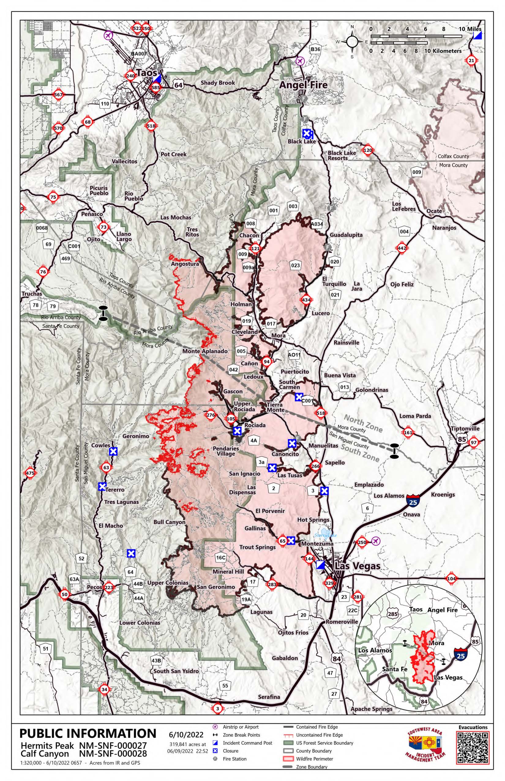
North Zone (SWIMT1): Yesterday, crews continued construction of contingency lines from Ripley Point west to Hodges Campground and have been continuing south to connect firelines into the Borrego Fire burn scar. With much of the western fire perimeter uncontained, fire managers have continued construction of this fireline to protect values at risk to the west and north if fire behavior increases in that area. As part of this construction, feller-bunchers are removing trees and masticators are working to chip smaller diameter material to create a fireline void of vegetation. Crews and heavy equipment will continue operations on the shaded fuel break from Pot Creek near NM Highway 518 on the west to the private land boundary near Black Lake on NM Highway 434 and north to NM Highway 64. Suppression repair continues around Chacon today, with firefighters working south down NM Highway 121 along the fire perimeter. Additional crews will be working along and inside the northeast fire perimeter, repairing firelines and constructing water bars on steep slopes to minimize resource damage when monsoon rains arrive.
South Zone (SWIMT2): Fire behavior was moderated yesterday, with the most activity occurring near the Rio Mora. Firefighters utilized helicopters to check the fire's edge and keep it from crossing the river. Air support is expected to continue today. Fire behavior could increase today with the potential for record high temperatures. However, winds will be a favorable west to southwest the next few days, which should help push the fire back into itself. The wildland fire module remains in place at Beatty's Cabin to monitor the fire and act if necessary. Control lines are complete with miles of hose laid and primed with water should it be needed. On the southwest corner of the fire, chipping and spreading slash continues, and crews will begin working on other suppression repair activities. Suppression repair groups have completed work on the east side. They are now focused on the southern edge and the Mineral Hills area. Over 250 miles of dozer line have been identified for repair over the next several weeks, in addition to reseeding, fixing fences, and installing erosion control features.
Evacuations: To view real-time evacuation information around the Hermits Peak and Calf Canyon Fires, visit: https://tinyurl.com/HermitsPeak for the evacuation map. The Ready, Set, Go evacuation guide is available in English and Spanish here: https://tinyurl.com/RSGNM For disaster assistance resources, visit: https://www.nmdhsem.org/2022-wildfires/
Weather: Continued hot and dry weather will persist today and through the weekend bringing critical fire weather conditions on Monday. Temperatures are expected to be in the mid-80s with a 15-40% relative humidity and a small chance of isolated thunderstorms. Winds will be out of the west-northwest today with sustained winds around 13 mph and gusts to 25 mph.
Closures and Restrictions: All National Forests in New Mexico have closures or restrictions in place due to extreme fire danger. To learn more about these closures and restrictions, visit: https://tinyurl.com/bdy5y99r. Information related to fire restrictions across public and private land can be found at: https://nmfireinfo.com/fire-restrictions/.
After Fire Flooding and Recovery Resources: After Wildfire New Mexico guide https://www.afterwildfirenm.org/ | Hermits Peak & Calf Canyon Fire Burned Area Emergency Response information https://inciweb.nwcg.gov/incident/8104/.
Smoke: An interactive smoke map at fire.airnow.gov/ allows you to zoom into your area to see the latest smoke conditions.
Fire Information: Office Hours: 8:00 AM – 8:00 PM | Phone: 505-356-2636 | Email: 2022.hermitspeak@firenet.gov Online: inciweb.nwcg.gov/incident/8069/ | https://www.facebook.com/CalfCanyonHermitsPeak| nmfireinfo.com |tinyurl.com/HermitsYouTube | Santa Fe NF |
Hermits Peak and Calf Canyon Fire Daily Update for June 10 2022
Related Incident: Calf Canyon
Publication Type: News
Hermits Peak and Calf Canyon Fires
June 10, 2022, Daily Update, 08:00 AM
Acres: 319,841 | Containment: 67% | Total personnel: 2,685 |
Start Date: Hermits Peak: April 6, 2022; Calf Canyon: April 19, 2022 | Cause: Hermits Peak: Spot fires from prescribed burn; Calf Canyon: Holdover fire from prescribed pile burn | Location: Located near Gallinas Canyon | Fuels: Heavy mixed conifer, ponderosa pine, brush, and grass
Highlights: Areas in "Set" evacuation status are open to residents only. Firefighters and heavy equipment are still working in these areas, and additional traffic from non-residents poses a hazard to fire personnel and the public. Please fill out the Private Property Suppression Repair Survey (https://tinyurl.com/suppressionrepair) if your property sustained damage from suppression activities. This information will assist fire officials and counties in evaluating properties and contacting owners.
South Zone (SWIMT2): Scattered showers over the fire yesterday helped minimize fire movement. However, the fire will become more active over the next few days as winds increase, temperatures rise and humidity drops. Yesterday the fire was most active in the Trampas Fire (2022) burn scar moving into Mora Flats. Water drops were made by helicopters early in the day, but afternoon storms grounded air operations. Air resources will continue with water drops to cool and slow the fire's edge as weather allows. Control lines are in place, and hoses are laid along the line and primed with water should they be needed. A wildland fire module specializing in wilderness firefighting remains at Beatty's Cabin to monitor the fire and act if necessary. Around Upper and Lower Colonias and Barillas Peak, crews are chipping and spreading slash and evaluating other suppression repair needs. Crews remain in the Mineral Hills area doing repair work and are finishing up repair activities on the east perimeter.
Closures and Restrictions: All National Forests in New Mexico have closures or restrictions in place due to extreme fire danger. To learn more about these closures and restrictions, visit: https://tinyurl.com/bdy5y99r. Information related to fire restrictions across public and private land can be found at: https://nmfireinfo.com/fire-restrictions/.
Email: 2022.hermitspeak@firenet.gov
Online: https://www.facebook.com/CalfCanyonHermitsPeak| nmfireinfo.com |tinyurl.com/HermitsYouTube | Santa Fe NF |
San Miguel County Sandbag Distribution June 9 2022
Related Incident: Calf Canyon
Publication Type: Announcement
FOR IMMEDIATE RELEASE: June 9, 2022 San Miguel/ Mora County
News Release Calf Canyon/ Hermits Peak Fire Sandbag Distribution Sites
Las Vegas – San Miguel County has established multiple Sandbag Distribution Sites for communities with potential risk of debris-flows and flooding. Tied sandbags operations are currently underway for residents to pick up at the following locations.
- Cabo Lucero Volunteer Fire Department - 21 County Rd A29
- Sapello-Rociada Volunteer Fire Department - 649 State Route 94 (N.M. 94)
- La Placita Volunteer Fire Department - 242 State Route 65 (N.M. 65)
- San Geronimo Volunteer Fire Department - County Road A19A (CR A19A)
- San Miguel County Public Works - 10 Airport Road
Sandbags is a simple, but effective way to prevent or reduce flood water damage. Properly filled and placed sandbags can act as a barrier to divert moving water around, instead of through, buildings. Sandbag construction does not guarantee a water-tight seal but is satisfactory for use in most situations. Sandbags are also used successfully to prevent overtopping of streams with levees, and for training current flows to specific areas
San Miguel County Evacuation Update June 9 2022
Related Incident: Calf Canyon
Publication Type: Closures
FOR IMMEDIATE RELEASE: June 9, 2022 @ 8:00 a.m. San Miguel/ Mora County News Release Calf Canyon/ Hermits Peak Fire Evacuation Updates
SAN MIGUEL COUNTY - The community of Holy Ghost has been DOWNGRADED to SET STATUS.
The community of Iron Gate will remain in GO STATUS. Traffic to communities in Set Status is open only to residents.
Current Evacuation Statuses: The community of Iron Gate is in GO STATUS. The communities of Upper and Lower Colonias, Lower La Posada, Bull Canyon, Cow Creek, El Macho, Calf Canyon, Tres Lagunas, and Holy Ghost are in SET STATUS.
The communities of Camp Luna, Cinder Road, Crestone, NMBHI, Romeroville East, and, Romeroville West, Taylor Wells, D Bibb West, D Bibb East, Gunner Trail, Hot Springs, Country Acres, Storrie Lake, 527-525- Hwy 518, Emplazado, County A3, Las Dispensas, Trout Springs, Gallinas, Lower Canyon Road, La Canada, E Las Tusas, W Las Tusas, E Sapello, W Sapello, Manuelitas, Canoncito, Tierra Monte – Canon, Big Pine, Canovas Canyon, El Porvenir, Porvenir Canyon, Chavez, Pendaries Valley East, Pendaries Village, Rociada, Lone Pine Mesa, San Ignacio, Mineral Hill, San Geronimo, Ojitos Frios, San Pablo, and Camino Rincon and Rivera Ridge (East of CR B52), Pecos Southwest (East of CR 53/ Rincon del Cielo), Pecos Southeast, East Pecos North, East Pecos South, and Pecos National Monument are in READY STATUS.
Residents are advised to be cautious during repopulation as fire personnel and fire apparatuses are still present. For additional information, you can call the Fire Information Line at (505) 356-2636. Residents of San Miguel, Mora, Taos, Colfax, and Santa Fe Counties should remain on high alert for changes to evacuation statuses and road closures.
Closures and Restrictions: All National Forests in New Mexico have closures or restrictions in place due to extreme fire danger. To learn more about these closures and restrictions, visit: https://tinyurl.com/bdy5y99r. Information related to fire restrictions across public and private land can be found at: https://nmfireinfo.com/fire-restrictions/
ROAD CLOSURES San Miguel County: N.M. 65 is closed at mile post 15. NF 86 is closed at the entrance of Cow Creek Ranch. N.M. 63 is closed at mile post 23.5 (Junction of N.M. 63 and Iron Gate Rd.) Only local traffic will be allowed on N.M. 63. All traffic to Bull Creek is closed. NF 92 is only open to residents. Link to Ready, Set Go, Wildland Fire Action Guide: https://cms6.revize.com/revize/sanmiguelcounty/FINAL-new-mexico-RSG-guide-2017_000.pdf
Hermits Peak and Calf Canyon Fire Daily Update for June 9 2022
Related Incident: Calf Canyon
Publication Type: News
Hermits Peak and Calf Canyon Fires
June 9, 2022, Daily Update, 08:00 AM
Acres: 318,599 | Containment: 65% | Total personnel: 2,672 |
Start Date: Hermits Peak: April 6, 2022; Calf Canyon: April 19, 2022 | Cause: Hermits Peak: Spot fires from prescribed burn; Calf Canyon: Holdover fire from prescribed pile burn | Location: Located near Gallinas Canyon | Fuels: Heavy mixed conifer, ponderosa pine, brush, and grass
Online: https://www.facebook.com/CalfCanyonHermitsPeak| nmfireinfo.com |tinyurl.com/HermitsYouTube | Santa Fe NF |
Hermits Peak and Calf Canyon Fire Daily Update for June 8 2022
Related Incident: Calf Canyon
Publication Type: News
Property owners whose properties have sustained damage from fire suppression activities are asked to fill out the online Property Owner Suppression Repair Survey: https://tinyurl.com/suppressionrepair. If you are in an evacuated area and don’t know if your property was damaged in active fire suppression, we still encourage you to complete this form which will assist fire officials and the county in evaluating properties and contacting property owners.
Operations:
North Zone (PNW2): Yesterday, crews continued construction of contingency lines from Ripley Point west to Hodges Campground and down to Forest Road 207, and have been working to connect firelines into the Borrego Fire burn scar. Heavy equipment continued work on the shaded fuelbreak southwest of Angel Fire, from Pot Creek near NM Highway 518 on the west to the private land boundary near Black Lake on NM Highway 434 and north to NM Highway 64. Feller-bunchers are working in the area to thin trees in the 100-300’ wide fuelbreak and dozers are creating a path to get the logs off the forest and into surrounding communities to be used as fuelwood/firewood. Operators are able to complete about one mile a day and this work is expected to continue for several more days. On the east side of the fire, suppression repair efforts near Guadalupita continue today as crews work to naturalize firelines and construct water bars on steep slopes to minimize resource damage during forecasted flash flooding.
This is the last operational shift for Pacific Northwest Team 2 and Southwest Incident Management Team 1 will be taking over command of the North Zone of the fire at 6:00 p.m. today.
South Zone (SWIMT2): Winds have been favorable for successful firing operations, and aircraft have been able to drop retardant along the control lines to reinforce these efforts. With cooler temperatures and higher humidity, minimal fire growth is expected today. Most crews will be removed from the Pecos Wilderness ahead of incoming forecasted weather. From Iron Gate Campground to Beatty’s Cabin, control lines are in place, and hoses are laid and primed with water should they be needed. Line is complete from Hamilton Mesa to the Trampas Fire (2002) burn scar below the confluence of Rio Valdez and Rio Mora and north of Beatty’s Cabin to the divide. Firefighters will remain in the Cowles and Geronimo area and structure protection measures, including sprinkler systems and control lines, are in place. Suppression repair work remains the focus around other areas of the fire perimeter, which aims to return the environment to a more natural state and prevent erosion.
Evacuations: To view real-time evacuation information around the Hermits Peak and Calf Canyon Fires, visit: tinyurl.com/HermitsPeak for the evacuation map. The Ready, Set, Go evacuation guide is available in English and Spanish here: https://tinyurl.com/RSGNM
Weather: Scattered thunderstorms are predicted across the fire area today with winds out of the south bringing increased cloud cover and a potential for flash flooding and lightning. Temperatures will remain warm in the mid-70s to low 80s with lighter sustained winds of 10 mph and gusts to 20. Relative humidity will increase today between 29-70% and remain elevated with thunderstorms predicted to continue tomorrow.
Closures and Restrictions: All National Forests in New Mexico have closures or restrictions in place due to extreme fire danger. To learn more about these closures and restrictions, visit: https://tinyurl.com/bdy5y99r. Information related to fire restrictions across public and private land can be found at: https://nmfireinfo.com/fire-restrictions/.
After Fire Flooding and Recovery Resources: After Wildfire New Mexico guide https://www.afterwildfirenm.org/ | Hermits Peak & Calf Canyon Fire Burned Area Emergency Response information https://inciweb.nwcg.gov/incident/8104/
Smoke: An interactive smoke map at fire.airnow.gov/ allows you to zoom into your area to see the latest smoke conditions.
Fire Information: Office Hours: 8:00 AM – 8:00 PM | Phone: 505-356-2636 | Email: 2022.hermitspeak@firenet.gov
Online: inciweb.nwcg.gov/incident/8069/ | https://www.facebook.com/CalfCanyonHermitsPeak| nmfireinfo.com |tinyurl.com/HermitsYouTube | Santa Fe NF |
San Miguel County Evacuation Update June 7 2022
Related Incident: Calf Canyon
Publication Type: Closures
FOR IMMEDIATE RELEASE: June 7, 2022 @ 8:00 a.m. San Miguel/ Mora County News Release Calf Canyon/ Hermits Peak Fire Evacuation Updates
SAN MIGUEL COUNTY - The community of Tres Lagunas has been DOWNGRADED to SET STATUS.
Current Evacuation Statuses: The community of Holy Ghost is in GO STATUS.
The communities of Upper and Lower Colonias, Lower La Posada, Bull Canyon, Cow Creek, El Macho, Calf Canyon, and Tres Lagunas are in SET STATUS.
The communities of Camp Luna, Cinder Road, Crestone, NMBHI, Romeroville East, and, Romeroville West, Taylor Wells, D Bibb West, D Bibb East, Gunner Trail, Hot Springs, Country Acres, Storrie Lake, 527-525- Hwy 518, Emplazado, County A3, Las Dispensas, Trout Springs, Gallinas, Lower Canyon Road, La Canada, E Las Tusas, W Las Tusas, E Sapello, W Sapello, Manuelitas, Canoncito, Tierra Monte – Canon, Big Pine, Canovas Canyon, El Porvenir, Porvenir Canyon, Chavez, Pendaries Valley East, Pendaries Village, Rociada, Lone Pine Mesa, San Ignacio, Mineral Hill, San Geronimo, Ojitos Frios, San Pablo, and Camino Rincon and Rivera Ridge (East of CR B52), Pecos Southwest (East of CR 53/ Rincon del Cielo), Pecos Southeast, East Pecos North, East Pecos South, and Pecos National Monument are in READY STATUS.
Residents are advised to be cautious during repopulation as fire personnel and fire apparatuses are still present.
For additional information, you can call the Fire Information Line at (505) 356-2636. Residents of San Miguel, Mora, Taos, Colfax, and Santa Fe Counties should remain on high alert for changes to evacuation statuses and road closures. Closures and Restrictions: All National Forests in New Mexico have closures or restrictions in place due to extreme fire danger. To learn more about these closures and restrictions, visit: https://tinyurl.com/bdy5y99r. Information related to fire restrictions across public and private land can be found at: https://nmfireinfo.com/fire-restrictions/. ROAD CLOSURES San Miguel County: N.M. 65 is closed at mile post 15. NF 86 is closed at the entrance of Cow Creek Ranch. N.M. 63 is closed at mile post 19 (Junction of N.M. 63 and Holy Ghost Canyon Rd.) All traffic to Bull Creek is closed. NF 92 is only open to residents.
Hermits Peak and Calf Canyon Fire Daily Update for June 7 2022
Related Incident: Calf Canyon
Publication Type: News
Operations:
Online: inciweb.nwcg.gov/incident/8069/ | https://www.facebook.com/CalfCanyonHermitsPeak| nmfireinfo.com |tinyurl.com/HermitsYouTube | Santa Fe NF |
Calf Canyon Hermits Peak Suppression Repair Landowner Survey
Related Incident: Calf Canyon
Publication Type: Announcement
Crews are conducting suppression repair activities around much of the fire perimeter. Suppression repair is a series of immediate post-fire actions taken to repair damages and minimize potential soil erosion and impacts that are a result of fire suppression activities. This work repairs the hand and dozer lines, roads, trails, staging areas, safety zones, and drop points used during the fire suppression efforts. It may also include fence and lock repair if damages were a direct result of fire suppression activities.
We’re asking private property owners that have sustained damage from FIRE SUPPRESSION activities to fill this form out, so we have names, addresses, and contact information.
This form is NOT for other fire damages, effects, or flood mitigation.DISCLAIMER: This information will be shared with managing agencies to assist with suppression repair activities. You can click the following link to complete the survey. https://forms.office.com/g/TU24jdYwBa