
Flood Watch 07232022 0700
Related Incident: Hermits Peak Fire
Publication Type: Announcement
Flood Watch Las Vegas/ Mora – The National Weather Service in Albuquerque has issued Flood Watch for The Hermits Peak-Calf Canyon burn scar for Mora County and San Miguel County in northeastern New Mexico.
FLOOD WATCH IN EFFECT FROM NOON MDT TODAY THROUGH THIS EVENING.
* WHAT... Flash flooding caused by excessive rainfall is possible.
* WHERE... Portions of north central and west central New Mexico, including the following areas, in north central New Mexico, East Slopes Sangre de Cristo Mountains, Jemez Mountains and Southern Sangre de Cristo Mountains. In west central New Mexico, Southwest Mountains.
* WHEN... From Noon MDT today through this evening.
* IMPACTS... Heavy rainfall may lead to excessive runoff over recent wildfire burn scars such as the Hermits Peak-Calf Canyon, Cooks Peak, Cerro Pelado and Black burn scars. Excessive runoff may result in flooding of rivers, creeks, streams, and other low-lying and flood-prone locations.
* ADDITIONAL DETAILS... Wildfire burn scars have already received heavy rainfall over the past few days and will be especially vulnerable to excessive runoff and flash flooding
. Be sure to stay up to date with information from local authorities. Heavy rainfall could trigger flash flooding of low-lying areas, urbanized street flooding, and debris flows in and near recent wildfire burn scars. Significant runoff may cause flooding of creeks and rivers.
Flood Watch 07222022
Related Incident: Hermits Peak Fire
Publication Type: Announcement
FOR IMMEDIATE RELEASE: July 22, 2022
FLOOD WATHC IN EFFECT FROM NONN MDT TODAY THROUGH THIS EVENING.
PLEASE CLICK ON THIS LINK FOR THE SAN MIGUEL COUNTY SHERIFF’S OFFICE FACEBOOK PAGE FOR DETAILED INFORMATION
Hermits Peak Calf Canyon Video Update July 22 2022
Related Incident: Hermits Peak Fire
Publication Type: News
Hermits Peak Canyon Calf Fire Update July 22 2022
Related Incident: Hermits Peak Fire
Publication Type: News
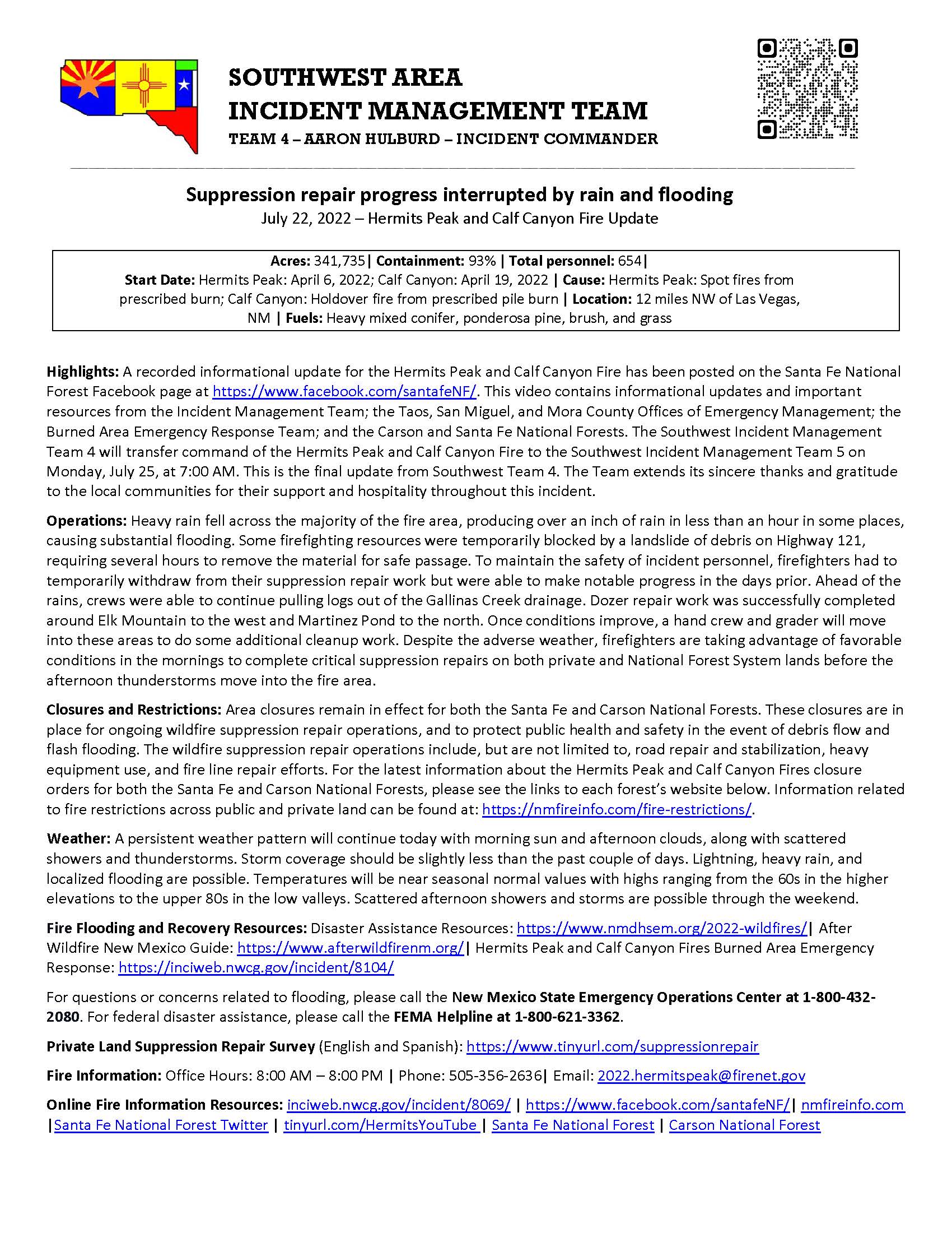
Suppression repair progress interrupted by rain and flooding
July 22, 2022 – Hermits Peak and Calf Canyon Fire Update
Acres: 341,735| Containment: 93% | Total personnel: 654|
Start Date: Hermits Peak: April 6, 2022; Calf Canyon: April 19, 2022 | Cause: Hermits Peak: Spot fires from prescribed burn; Calf Canyon: Holdover fire from prescribed pile burn | Location: 12 miles NW of Las Vegas, NM | Fuels: Heavy mixed conifer, ponderosa pine, brush, and grass
Highlights: A recorded informational update for the Hermits Peak and Calf Canyon Fire has been posted on the Santa Fe National Forest Facebook page at https://www.facebook.com/santafeNF/. This video contains informational updates and important resources from the Incident Management Team; the Taos, San Miguel, and Mora County Offices of Emergency Management; the Burned Area Emergency Response Team; and the Carson and Santa Fe National Forests. The Southwest Incident Management Team 4 will transfer command of the Hermits Peak and Calf Canyon Fire to the Southwest Incident Management Team 5 on Monday, July 25, at 7:00 AM. This is the final update from Southwest Team 4. The Team extends its sincere thanks and gratitude to the local communities for their support and hospitality throughout this incident.
Operations: Heavy rain fell across the majority of the fire area, producing over an inch of rain in less than an hour in some places, causing substantial flooding. Some firefighting resources were temporarily blocked by a landslide of debris on Highway 121, requiring several hours to remove the material for safe passage. To maintain the safety of incident personnel, firefighters had to temporarily withdraw from their suppression repair work but were able to make notable progress in the days prior. Ahead of the rains, crews were able to continue pulling logs out of the Gallinas Creek drainage. Dozer repair work was successfully completed around Elk Mountain to the west and Martinez Pond to the north. Once conditions improve, a hand crew and grader will move into these areas to do some additional cleanup work. Despite the adverse weather, firefighters are taking advantage of favorable conditions in the mornings to complete critical suppression repairs on both private and National Forest System lands before the afternoon thunderstorms move into the fire area.
Closures and Restrictions: Area closures remain in effect for both the Santa Fe and Carson National Forests. These closures are in place for ongoing wildfire suppression repair operations, and to protect public health and safety in the event of debris flow and flash flooding. The wildfire suppression repair operations include, but are not limited to, road repair and stabilization, heavy equipment use, and fire line repair efforts. For the latest information about the Hermits Peak and Calf Canyon Fires closure orders for both the Santa Fe and Carson National Forests, please see the links to each forest’s website below. Information related to fire restrictions across public and private land can be found at: https://nmfireinfo.com/fire-restrictions/.
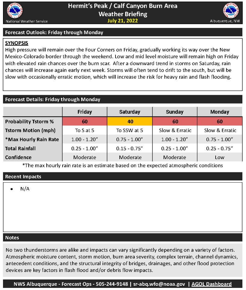
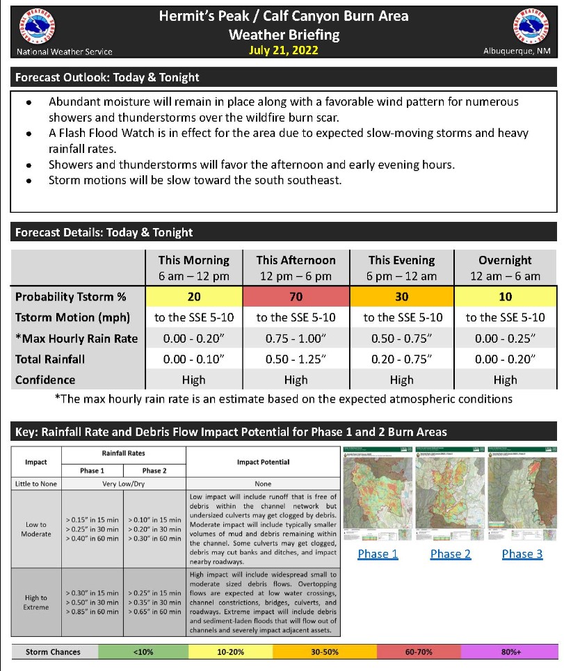
Weather: A persistent weather pattern will continue today with morning sun and afternoon clouds, along with scattered showers and thunderstorms. Storm coverage should be slightly less than the past couple of days. Lightning, heavy rain, and localized flooding are possible. Temperatures will be near seasonal normal values with highs ranging from the 60s in the higher elevations to the upper 80s in the low valleys. Scattered afternoon showers and storms are possible through the weekend.
Fire Flooding and Recovery Resources: Disaster Assistance Resources: https://www.nmdhsem.org/2022-wildfires/| After Wildfire New Mexico Guide: https://www.afterwildfirenm.org/| Hermits Peak and Calf Canyon Fires Burned Area Emergency Response: https://inciweb.nwcg.gov/incident/8104/
For questions or concerns related to flooding, please call the New Mexico State Emergency Operations Center at 1-800-432-2080. For federal disaster assistance, please call the FEMA Helpline at 1-800-621-3362.
Private Land Suppression Repair Survey (English and Spanish): https://www.tinyurl.com/suppressionrepair
Fire Information: Office Hours: 8:00 AM – 8:00 PM | Phone: 505-356-2636| Email: 2022.hermitspeak@firenet.gov
Online Fire Information Resources: inciweb.nwcg.gov/incident/8069/ | https://www.facebook.com/santafeNF/| nmfireinfo.com |Santa Fe National Forest Twitter | tinyurl.com/HermitsYouTube | Santa Fe National Forest | Carson National Forest
Flash Flood Warning 1648 MDT on July 21 2022
Related Incident: Hermits Peak Fire
Publication Type: Announcement
Flash Flood Warning
The National Weather Service in Albuquerque has extended the
* Flash Flood Warning for...
The Hermits Peak and Calf Canyon Burn Scar in...
Northwestern San Miguel County in northeastern New Mexico...
* Until 700 PM MDT.
Flash Flood Warning 252 PM MDT July 21 2022
Related Incident: Hermits Peak Fire
Publication Type: Announcement
The National Weather Service in Albuquerque has extended the
* Flash Flood Warning for...
The Hermits Peak and Calf Canyon Burn Scar in...
Northwestern San Miguel County in northeastern New Mexico...
* Until 500 PM MDT.
* At 252 PM MDT, Doppler radar indicated thunderstorms producing
heavy rain over the Hermits Peak and Calf Canyon Burn Scar.
Between 0.75 and 1.5 inches of rain have fallen. Additional
rainfall amounts of 0.25 to 1 inch are possible in the warned
area. Flash flooding is ongoing or expected to begin shortly.
Excessive rainfall over the burn scar will impact the Tecolote Creek
and Gallinas River drainage areas including Cabo Lucero Creek, Canon
Mesteno, Ojitos Frios Creek, Tecolote Creek, Porvenir Canyon, Arroyo
Pecos, Agua Zarca and Vegosa Creek. The debris flow can consist of
rock, mud, vegetation and other loose materials.
HAZARD...Life threatening flash flooding. Thunderstorms
producing flash flooding in and around the Hermits
Peak and Calf Canyon Burn Scar.
SOURCE...Radar.
IMPACT...Life threatening flash flooding of areas in and around
the Hermits Peak and Calf Canyon Burn Scar.
* Some locations that will experience flash flooding include...
Las Vegas, El Porvenir, Montezuma, Storrie Lake State Park,
Mineral Hill, Gallinas, San Geronimo, San Pablo and Ojitos Frios.
You can read more here.
FLASH FLOOD WARNING 07212022
Related Incident: Hermits Peak Fire
Publication Type: Announcement
The National Weather Service in Albuquerque has issued a * Flash Flood Warning for... The Hermits Peak and Calf Canyon Burn Scar in... Northwestern San Miguel County in northeastern New Mexico... * Until 300 PM MDT.

For More Information Click Here.
Flood Watch July 21 2022
Related Incident: Hermits Peak Fire
Publication Type: Announcement
Flood Watch
Las Vegas/ Mora –
The National Weather Service in Albuquerque has issued Flood Watch for The Hermits Peak-Calf Canyon burn scar for Mora County and San Miguel County in northeastern New Mexico.
FLOOD WATCH IN EFFECT FROM NOON MDT TODAY THROUGH THIS EVENING
* WHAT... Flash flooding caused by excessive rainfall over vulnerable wildfire burn scars is possible.
* WHERE... A portion of north central New Mexico, including the following area, East Slopes Sangre de Cristo Mountains.
* WHEN... From Noon MDT today through this evening.
Hermits Peak Calf Canyon Morning Video Update for July 20
Related Incident: Hermits Peak Fire
Publication Type: News
Flash Flood Warning
Related Incident: Hermits Peak Fire
Publication Type: Announcement
MORA – The National Weather Service in Albuquerque has issued a Flash Flood Warning for The Cooks Peak burn scar in North Central Mora County in northeastern New Mexico until 430 PM MDT. At 157 PM MDT, Doppler radar indicated thunderstorms producing heavy rain over the Cooks Peak Burn Scar. Flash flooding is ongoing or expected to begin shortly. Excessive rainfall over the burn scar will produce debris flows which can consist of rock, mud, vegetation, and other loose materials. HAZARD... Life threatening flash flooding. Thunderstorms producing flash flooding. IMPACT... Life threatening flash flooding of areas in and around the Cooks Peak Burn Scar. Some locations that will experience flash flooding include... Ocate. Please stay up to date by listening to local radio and television for further information. Local officials may call for evacuations in specific areas with the greatest risk.