
Hermits Peak Calf Canyon Fire Daily Update 72922
Related Incident: Calf Canyon
Publication Type: News
Containment increases as crews contend with wet conditions
July 29, 2022 – Calf Canyon Fire UpdateAcres: 341,735| Containment: 94% | Total personnel: 417|Start Date: Hermits Peak: April 6, 2022; Calf Canyon: April 19, 2022 | Cause: Hermits Peak: Spot fires from prescribed burn; Calf Canyon: Holdover fire from prescribed pile burn | Location: 12 miles NW of Las Vegas, NM | Fuels: Heavy mixed conifer, ponderosa pine, brush, and grass
Weather: Yesterday, scattered thunderstorms developed in the afternoon and evening with northeast movement. Areas from Taos County to Rociada and west of Mora received up to half an inch. Additional storms were isolated over the I-25 corridor and portions of the fire by late afternoon. Occasional cloud to ground lightning and localized flooding of draws and creeks is possible. Scattered to numerous afternoon showers and thunderstorms remain in the forecast into this weekend with drying early next week. Temperatures will remain average to a little below average into this weekend.
Hermits Peak Calf Canyon Daily Update 72722
Related Incident: Calf Canyon
Publication Type: News
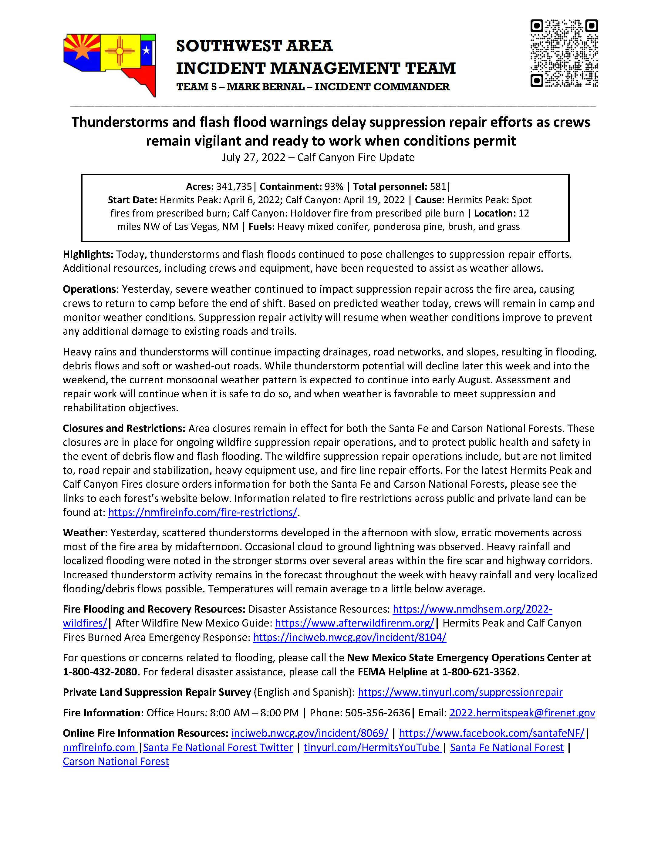
Thunderstorms and flash flood warnings delay suppression repair efforts as crews remain vigilant and ready to work when conditions permit
July 27, 2022 – Calf Canyon Fire Update
Highlights: Today, thunderstorms and flash floods continued to pose challenges to suppression repair efforts. Additional resources, including crews and equipment, have been requested to assist as weather allows.
Operations: Yesterday, severe weather continued to impact suppression repair across the fire area, causing crews to return to camp before the end of shift. Based on predicted weather today, crews will remain in camp and monitor weather conditions. Suppression repair activity will resume when weather conditions improve to prevent any additional damage to existing roads and trails.
Heavy rains and thunderstorms will continue impacting drainages, road networks, and slopes, resulting in flooding, debris flows and soft or washed-out roads. While thunderstorm potential will decline later this week and into the weekend, the current monsoonal weather pattern is expected to continue into early August. Assessment and repair work will continue when it is safe to do so, and when weather is favorable to meet suppression and rehabilitation objectives.
Closures and Restrictions: Area closures remain in effect for both the Santa Fe and Carson National Forests. These closures are in place for ongoing wildfire suppression repair operations, and to protect public health and safety in the event of debris flow and flash flooding. The wildfire suppression repair operations include, but are not limited to, road repair and stabilization, heavy equipment use, and fire line repair efforts. For the latest Hermits Peak and Calf Canyon Fires closure orders information for both the Santa Fe and Carson National Forests, please see the links to each forest’s website below. Information related to fire restrictions across public and private land can be found at: https://nmfireinfo.com/fire-restrictions/.
Weather: Yesterday, scattered thunderstorms developed in the afternoon with slow, erratic movements across most of the fire area by midafternoon. Occasional cloud to ground lightning was observed. Heavy rainfall and localized flooding were noted in the stronger storms over several areas within the fire scar and highway corridors. Increased thunderstorm activity remains in the forecast throughout the week with heavy rainfall and very localized flooding/debris flows possible. Temperatures will remain average to a little below average.
Fire Flooding and Recovery Resources: Disaster Assistance Resources: https://www.nmdhsem.org/2022-wildfires/| After Wildfire New Mexico Guide: https://www.afterwildfirenm.org/| Hermits Peak and Calf Canyon Fires Burned Area Emergency Response: https://inciweb.nwcg.gov/incident/8104/
For questions or concerns related to flooding, please call the New Mexico State Emergency Operations Center at 1-800-432-2080. For federal disaster assistance, please call the FEMA Helpline at 1-800-621-3362.
Private Land Suppression Repair Survey (English and Spanish): https://www.tinyurl.com/suppressionrepair
Fire Information: Office Hours: 8:00 AM – 8:00 PM | Phone: 505-356-2636| Email: 2022.hermitspeak@firenet.gov
Online Fire Information Resources: inciweb.nwcg.gov/incident/8069/ | https://www.facebook.com/santafeNF/| nmfireinfo.com |Santa Fe National Forest Twitter | tinyurl.com/HermitsYouTube | Santa Fe National Forest | Carson National Forest
Flash Flood Warning San Miguel County
Related Incident: Calf Canyon
Publication Type: Announcement
Event: Flash Flood Warning Alert:
*Flash Flood Warning for... The Hermits Peak and Calf Canyon Burn Scar in... N
orthwestern San Miguel County in northeastern New Mexico...
* Until 1000 PM MDT. * At 607 PM MDT,
Doppler radar indicated thunderstorms producing heavy rain over the Hermits Peak and Calf Canyon Burn Scar. Up to 0.75 inches of rain have fallen. The expected rainfall rate is 1.25 inches in 1 hour. Additional rainfall amounts up to 1.25 inches are possible in the warned area. Flash flooding is ongoing or expected to begin shortly. Excessive rainfall over the burn scar will impact the Tecolote Creek and Gallinas River drainage areas including Cabo Lucero Creek, Canon Mesteno, Ojitos Frios Creek, Tecolote Creek, Porvenir Canyon, Arroyo Pecos, Agua Zarca and Vegosa Creek. The debris flow can consist of rock, mud, vegetation and other loose materials. HAZARD...Life threatening flash flooding. Thunderstorms producing flash flooding in and around the Hermits Peak and Calf Canyon Burn Scar. SOURCE...Radar.
IMPACT...Life threatening flash flooding of areas in and around the Hermits Peak and Calf Canyon Burn Scar. * Some locations that will experience flash flooding include... Las Vegas, El Porvenir, Montezuma, Storrie Lake State Park, Mineral Hill, Gallinas, San Geronimo, San Pablo and Ojitos Frios. This includes the following highways... State Road 283 between Mile Markers 1 and 12...and near Mile Marker 14. State Road 65 between Mile Markers 1 and 14. State Road 518 between Mile Markers 1 and 9. Interstate 25 between Mile Markers 343 and 349.
F
LASH FLOOD...RADAR INDICATED FLASH FLOOD DAMAGE THREAT...CONSIDERABLE EXPECTED RAINFALL RATE...1.25 INCHES IN 1 HOUR Instructions: Turn around, don`t drown when encountering flooded roads. Most flood deaths occur in vehicles. Target
Area: San Miguel
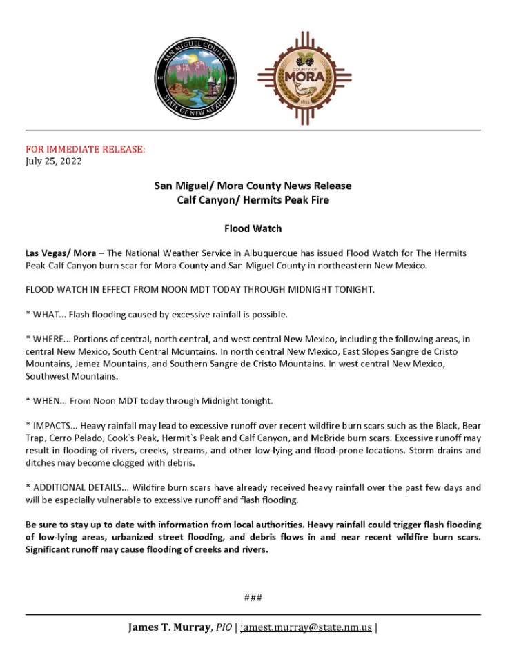
Flood Watch 07252022
Related Incident: Calf Canyon
Publication Type: News
Event: Flash Flood Warning Alert:
The National Weather Service in Albuquerque has issued a
· Flash Flood Warning
for... South Central Taos County in north central New Mexico... Northwestern Mora County in northeastern New Mexico...
· Until 430 PM MDT. · At 120 PM MDT,
Doppler radar indicated thunderstorms producing heavy rain across the warned area. Up to 0.5 inches of rain have fallen. The expected rainfall rate is 1.5 inches in 1 hour. Additional rainfall amounts up to 0.75 inches are possible in the warned area. Flash flooding is ongoing or expected to begin shortly. Excessive rainfall will impact Far northwest Hermits Peak Calf Canyon Burn Scar including Alamitos Creek, Rito Angostura, Piedra Creek, and the Rio Pueblo downstream through Tres Ritos, Vadito, and Picuris Pueblo. The debris flow can consist of rock, mud, vegetation and other loose materials. HAZARD...Life threatening flash flooding. Thunderstorms producing flash flooding. SOURCE...Radar. IMPACT...Life threatening flash flooding of creeks and streams, urban areas, highways, streets and underpasses. · Some locations that will experience flash flooding include... Tres Ritos, Vadito, Picuris Pueblo and Rio Lucio. This includes the following highways... State Road 518 between Mile Markers 40 and 58.
FLASH FLOOD...RADAR INDICATED FLASH FLOOD DAMAGE THREAT...CONSIDERABLE EXPECTED RAINFALL RATE...1.5 INCHES IN 1 HOUR
Instructions: Turn around, don`t drown when encountering flooded roads. Most flood deaths occur in vehicles. Do not camp along streams and rivers. Remain alert when hiking in steep, narrow canyons. Know where you are relative to low spots and drainages.
Hermits Peak Calf Canyon Fire Update July 25 2022
Related Incident: Calf Canyon
Publication Type: News
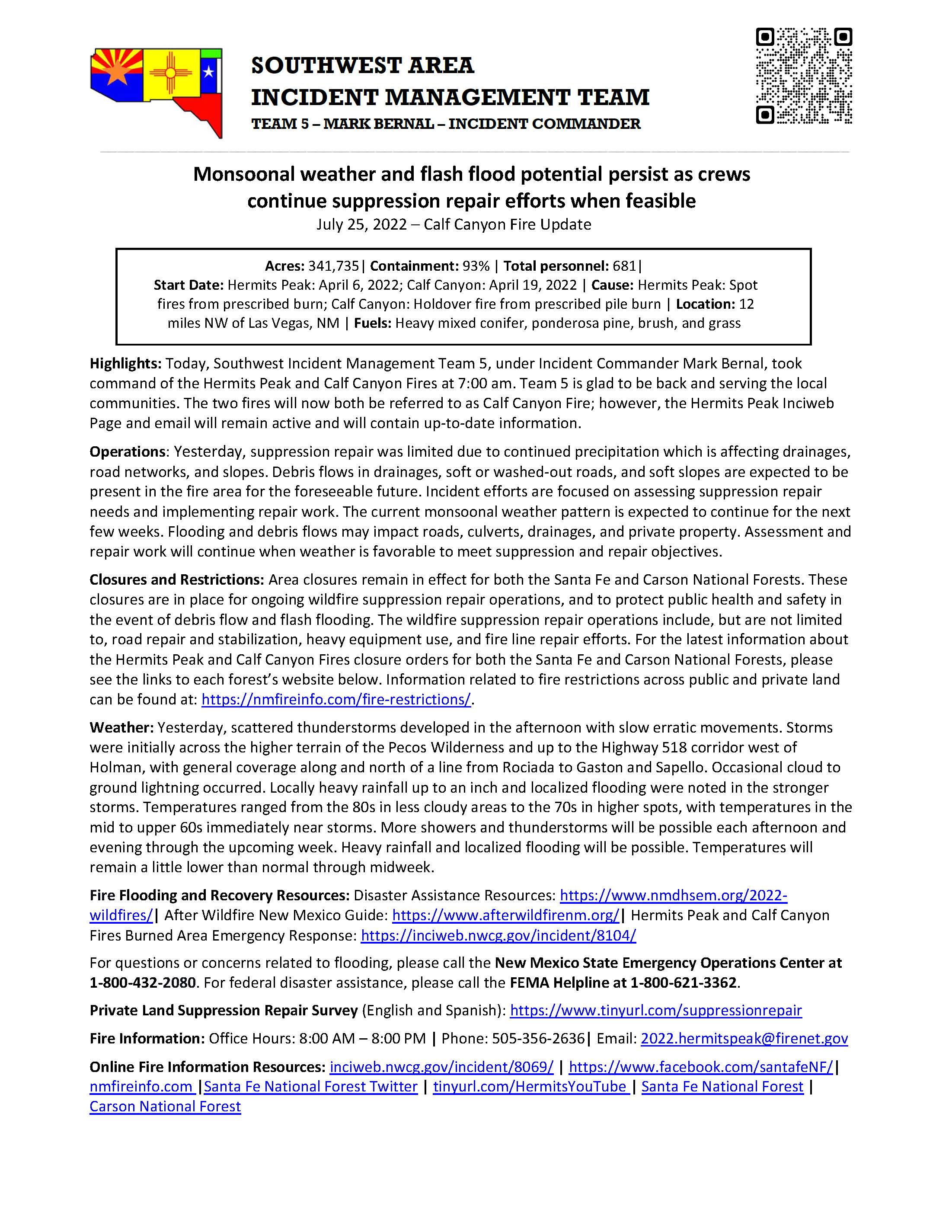
Monsoonal weather and flash flood potential persist as crews
continue suppression repair efforts when feasible
July 25, 2022 – Calf Canyon Fire Update
Acres: 341,735| Containment: 93% | Total personnel: 681|
Start Date: Hermits Peak: April 6, 2022; Calf Canyon: April 19, 2022 | Cause: Hermits Peak: Spot fires from prescribed burn; Calf Canyon: Holdover fire from prescribed pile burn | Location: 12 miles NW of Las Vegas, NM | Fuels: Heavy mixed conifer, ponderosa pine, brush, and grass
Operations: Yesterday, suppression repair was limited due to continued precipitation which is affecting drainages, road networks, and slopes. Debris flows in drainages, soft or washed-out roads, and soft slopes are expected to be present in the fire area for the foreseeable future. Incident efforts are focused on assessing suppression repair needs and implementing repair work. The current monsoonal weather pattern is expected to continue for the next few weeks. Flooding and debris flows may impact roads, culverts, drainages, and private property. Assessment and repair work will continue when weather is favorable to meet suppression and repair objectives.
Weather: Yesterday, scattered thunderstorms developed in the afternoon with slow erratic movements. Storms were initially across the higher terrain of the Pecos Wilderness and up to the Highway 518 corridor west of Holman, with general coverage along and north of a line from Rociada to Gaston and Sapello. Occasional cloud to ground lightning occurred. Locally heavy rainfall up to an inch and localized flooding were noted in the stronger storms. Temperatures ranged from the 80s in less cloudy areas to the 70s in higher spots, with temperatures in the mid to upper 60s immediately near storms. More showers and thunderstorms will be possible each afternoon and evening through the upcoming week. Heavy rainfall and localized flooding will be possible.
Temperatures will remain a little lower than normal through midweek.
Private Land Suppression Repair Survey (English and Spanish): https://www.tinyurl.com/suppressionrepair
Fire Information: Office Hours: 8:00 AM – 8:00 PM | Phone: 505-356-2636| Email: 2022.hermitspeak@firenet.gov
Online Fire Information Resources: inciweb.nwcg.gov/incident/8069/ | https://www.facebook.com/santafeNF/| nmfireinfo.com |Santa Fe National Forest Twitter | tinyurl.com/HermitsYouTube | Santa Fe National Forest | Carson National Forest
Flash Flood Warning 557 MDT on 07232022
Related Incident: Calf Canyon
Publication Type: Announcement
Flash Flood Warning Alert:
The National Weather Service in Albuquerque has issued a
· Flash Flood Warning for... The Hermits Peak Calf Canyon Burn Scar in... South Central Taos County in north central New Mexico... Western Mora County in northeastern New Mexico... Northwestern San Miguel County in northeastern New Mexico...
· Until 700 PM MDT.
· At 357 PM MDT, Doppler radar indicated thunderstorms producing moderate rain over the Hermits Peak Calf Canyon Burn Scar near Rociada and Tierra Monte. Between 0.25 and 0.5 inches of rain have fallen. Additional rainfall amounts up to 0.25 inches are possible in the warned area. Flash flooding is ongoing or expected to begin shortly. Excessive rainfall over the burn scar will impact Manuelitas Creek, Sapello River, Rio San Jose, Santiago Creek, Rito Cebolla, Rio La Casa, Vigil Creek, Coyote Creek, Mora River, and La Canada del Carro. The debris flow can consist of rock, mud, vegetation and other loose materials. HAZARD...Life threatening flash flooding. Thunderstorms producing flash flooding in and around the Hermits Peak Calf Canyon Burn Scar. SOURCE...Radar. IMPACT...Life threatening flash flooding of areas in and around the Hermits Peak Calf Canyon Burn Scar.
· Some locations that will experience flash flooding include... Mora, Ledoux, Morphy Lake State Park, Cleveland, Tierra Monte, La Cueva, Holman, Gascon, Sapello, Chacon, South Carmen, Monte Aplanado, Luceros, Rainsville, Rociada, Manuelitas, Golondrinas, El Turquillo, San Ignacio and Guadalupita. This includes the following recreation areas... Morphy Lake State Park. This includes the following highways... State Road 94 between Mile Markers 1 and 18. State Road 266 between Mile Markers 0 and 6. State Road 276 between Mile Markers 0 and 5. State Road 518 between Mile Markers 9 and 47. State Road 434 between Mile Markers 0 and 14. State Road 283 near Mile Marker 13. State Road 105 between Mile Markers 0 and 9. State Road 121 between Mile Markers 0 and 8. FL
FASH FLOOD...RADAR INDICATED FLASH FLOOD DAMAGE THREAT...CONSIDERABLE
Instructions: Runoff from rainfall will cause elevated water levels within vulnerable drainages in and downstream of the Hermits Peak-Calf Canyon fire burn area. Do not camp along streams and rivers. Remain alert when hiking in steep, narrow canyons. Know where you are relative to low spots and drainages.
Target Area: Mora
San Miguel
Taos
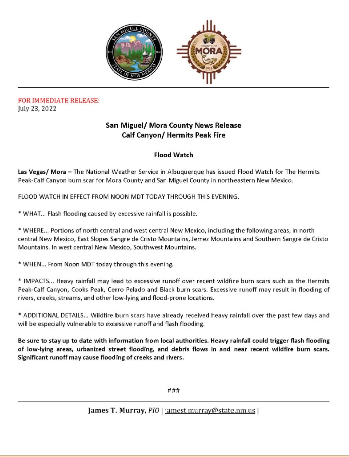
Flood Watch 07232022 0700
Related Incident: Calf Canyon
Publication Type: Announcement
Flood Watch Las Vegas/ Mora – The National Weather Service in Albuquerque has issued Flood Watch for The Hermits Peak-Calf Canyon burn scar for Mora County and San Miguel County in northeastern New Mexico.
FLOOD WATCH IN EFFECT FROM NOON MDT TODAY THROUGH THIS EVENING.
* WHAT... Flash flooding caused by excessive rainfall is possible.
* WHERE... Portions of north central and west central New Mexico, including the following areas, in north central New Mexico, East Slopes Sangre de Cristo Mountains, Jemez Mountains and Southern Sangre de Cristo Mountains. In west central New Mexico, Southwest Mountains.
* WHEN... From Noon MDT today through this evening.
* IMPACTS... Heavy rainfall may lead to excessive runoff over recent wildfire burn scars such as the Hermits Peak-Calf Canyon, Cooks Peak, Cerro Pelado and Black burn scars. Excessive runoff may result in flooding of rivers, creeks, streams, and other low-lying and flood-prone locations.
* ADDITIONAL DETAILS... Wildfire burn scars have already received heavy rainfall over the past few days and will be especially vulnerable to excessive runoff and flash flooding.
Be sure to stay up to date with information from local authorities. Heavy rainfall could trigger flash flooding of low-lying areas, urbanized street flooding, and debris flows in and near recent wildfire burn scars. Significant runoff may cause flooding of creeks and rivers.
Flood Watch 07222022
Related Incident: Calf Canyon
Publication Type: Announcement
FOR IMMEDIATE RELEASE: July 22, 2022
FLOOD WATHC IN EFFECT FROM NONN MDT TODAY THROUGH THIS EVENING.
PLEASE CLICK ON THIS LINK FOR THE SAN MIGUEL COUNTY SHERIFF’S OFFICE FACEBOOK PAGE FOR DETAILED INFORMATION
Hermits Peak Calf Canyon Video Update 72222
Related Incident: Calf Canyon
Publication Type: News
Hermits Peak Calf Canyon Fire Update 72222
Related Incident: Calf Canyon
Publication Type: News
Suppression repair progress interrupted by rain and flooding
Acres: 341,735| Containment: 93% | Total personnel: 654|
Start Date: Hermits Peak: April 6, 2022; Calf Canyon: April 19, 2022 | Cause: Hermits Peak: Spot fires from prescribed burn; Calf Canyon: Holdover fire from prescribed pile burn | Location: 12 miles NW of Las Vegas, NM | Fuels: Heavy mixed conifer, ponderosa pine, brush, and grass
Highlights: A recorded informational update for the Hermits Peak and Calf Canyon Fire has been posted on the Santa Fe National Forest Facebook page at https://www.facebook.com/santafeNF/. This video contains informational updates and important resources from the Incident Management Team; the Taos, San Miguel, and Mora County Offices of Emergency Management; the Burned Area Emergency Response Team; and the Carson and Santa Fe National Forests. The Southwest Incident Management Team 4 will transfer command of the Hermits Peak and Calf Canyon Fire to the Southwest Incident Management Team 5 on Monday, July 25, at 7:00 AM. This is the final update from Southwest Team 4. The Team extends its sincere thanks and gratitude to the local communities for their support and hospitality throughout this incident.
Operations: Heavy rain fell across the majority of the fire area, producing over an inch of rain in less than an hour in some places, causing substantial flooding. Some firefighting resources were temporarily blocked by a landslide of debris on Highway 121, requiring several hours to remove the material for safe passage. To maintain the safety of incident personnel, firefighters had to temporarily withdraw from their suppression repair work but were able to make notable progress in the days prior. Ahead of the rains, crews were able to continue pulling logs out of the Gallinas Creek drainage. Dozer repair work was successfully completed around Elk Mountain to the west and Martinez Pond to the north. Once conditions improve, a hand crew and grader will move into these areas to do some additional cleanup work. Despite the adverse weather, firefighters are taking advantage of favorable conditions in the mornings to complete critical suppression repairs on both private and National Forest System lands before the afternoon thunderstorms move into the fire area.
Closures and Restrictions: Area closures remain in effect for both the Santa Fe and Carson National Forests. These closures are in place for ongoing wildfire suppression repair operations, and to protect public health and safety in the event of debris flow and flash flooding. The wildfire suppression repair operations include, but are not limited to, road repair and stabilization, heavy equipment use, and fire line repair efforts. For the latest information about the Hermits Peak and Calf Canyon Fires closure orders for both the Santa Fe and Carson National Forests, please see the links to each forest’s website below. Information related to fire restrictions across public and private land can be found at: https://nmfireinfo.com/fire-restrictions/.
Weather: A persistent weather pattern will continue today with morning sun and afternoon clouds, along with scattered showers and thunderstorms. Storm coverage should be slightly less than the past couple of days. Lightning, heavy rain, and localized flooding are possible. Temperatures will be near seasonal normal values with highs ranging from the 60s in the higher elevations to the upper 80s in the low valleys. Scattered afternoon showers and storms are possible through the weekend.
Fire Flooding and Recovery Resources: Disaster Assistance Resources: https://www.nmdhsem.org/2022-wildfires/| After Wildfire New Mexico Guide: https://www.afterwildfirenm.org/| Hermits Peak and Calf Canyon Fires Burned Area Emergency Response: https://inciweb.nwcg.gov/incident/8104/
For questions or concerns related to flooding, please call the New Mexico State Emergency Operations Center at 1-800-432-2080. For federal disaster assistance, please call the FEMA Helpline at 1-800-621-3362.
Private Land Suppression Repair Survey (English and Spanish): https://www.tinyurl.com/suppressionrepair
Fire Information: Office Hours: 8:00 AM – 8:00 PM | Phone: 505-356-2636| Email: 2022.hermitspeak@firenet.gov
Online Fire Information Resources: inciweb.nwcg.gov/incident/8069/ | https://www.facebook.com/santafeNF/| nmfireinfo.com |Santa Fe National Forest Twitter | tinyurl.com/HermitsYouTube | Santa Fe National Forest | Carson National Forest