
WindigoPotterBig SwampShelter Fires Update August 07 2022
Related Incident: Potter Fire
Publication Type: News
Windigo-Potter-Big Swamp-Shelter Fires Update – August 07, 2022
Fire Information Phone Line: 206-473-8645 (8am - 7pm)
Email: 2022.Windigo@firenet.gov
Potter Fire (& Shelter) InciWeb: https://inciweb.nwcg.gov/incident/8291/
Windigo Fire (& Big Swamp) InciWeb: https://inciweb.nwcg.gov/incident/8292/
Facebook: https://www.facebook.com/Windigo-Fire-and-Potter-Fire-Information-109233838550715
Containment on the Windigo Fire increased to 15% as firefighters continued to make progress on all fires in the area. The incident command team is currently managing 237 sq. miles across the Umpqua, Willamette, Deschutes, and Fremont-Winema National Forests—which includes 27 known fires. Eight have active fire behavior. All 27 fires have resources assigned. Weather will challenge suppression efforts over the next few days as crews battle higher temperatures and dryer fuels. For firefighter and public safety, follow the Fire Closure Orders.
Yesterday, crews and heavy equipment successfully dug line around the entire perimeters of the Windigo and Potter Fires. Today, ground resources will continue to plumb, mop-up, hold and secure the fire line of the Windigo Fire. Firefighters on the Potter Fire will continue to develop and strengthen alternate and contingency lines. Air resources will support Initial Attack if any spot fires occur outside of the fire perimeters. Today, they will include eight Type 1 Helicopters and one Type 3, with 2 fixed-wing scoopers available out of Eugene.
The Big Swamp Fire grew an estimated 10-15 acres. Three handcrews, 2 engines, and multiple pieces of heavy equipment will be working on that fire today with more resources en route. The small fire near Big Swamp, named 210, is still .2 acres. Shelter Fire is still under 5 acres and is secure. An additional start began south of Potter Mountain, named 212, and is .5 acres. Crews will continue to secure fire line and search for remaining pockets of heat on the smaller fires.
Today’s weather changes are expected to increase fire behavior. High temperatures will reach 86-92 degrees. Wind direction will change midday and flow from a NW direction with speeds between 5-8 mph and gusts of up to 15 mph on ridge tops and valleys. Fire spotting distances may be up to ¼ - ½ mile with a 90% chance of ignition on the dry fuels. Smoke will be more visible today as unburned islands of green fuel burn within the interior of the fire perimeters; visit AirNow.gov for more information.
Help keep our firefighters and yourself safe by obeying the forest closures, avoiding the entire restricted area. A large closure area is necessary to ensure that firefighters can focus on managing the fire, not evacuating visitors, should conditions on the fire change rapidly.
Windigo Fire
Acreage: Approx. 1,052 acres
Containment: 15%
Location: 20 miles southwest of La Pine, OR
Cause: Lightning
Potter Fire
Acreage: Approx. 185 acres
Containment: 0%
Location: 8 miles northeast of Toketee Lake
Cause: Lightning
Closures: For firefighter and public safety follow the Windigo and Potter Closure Orders.
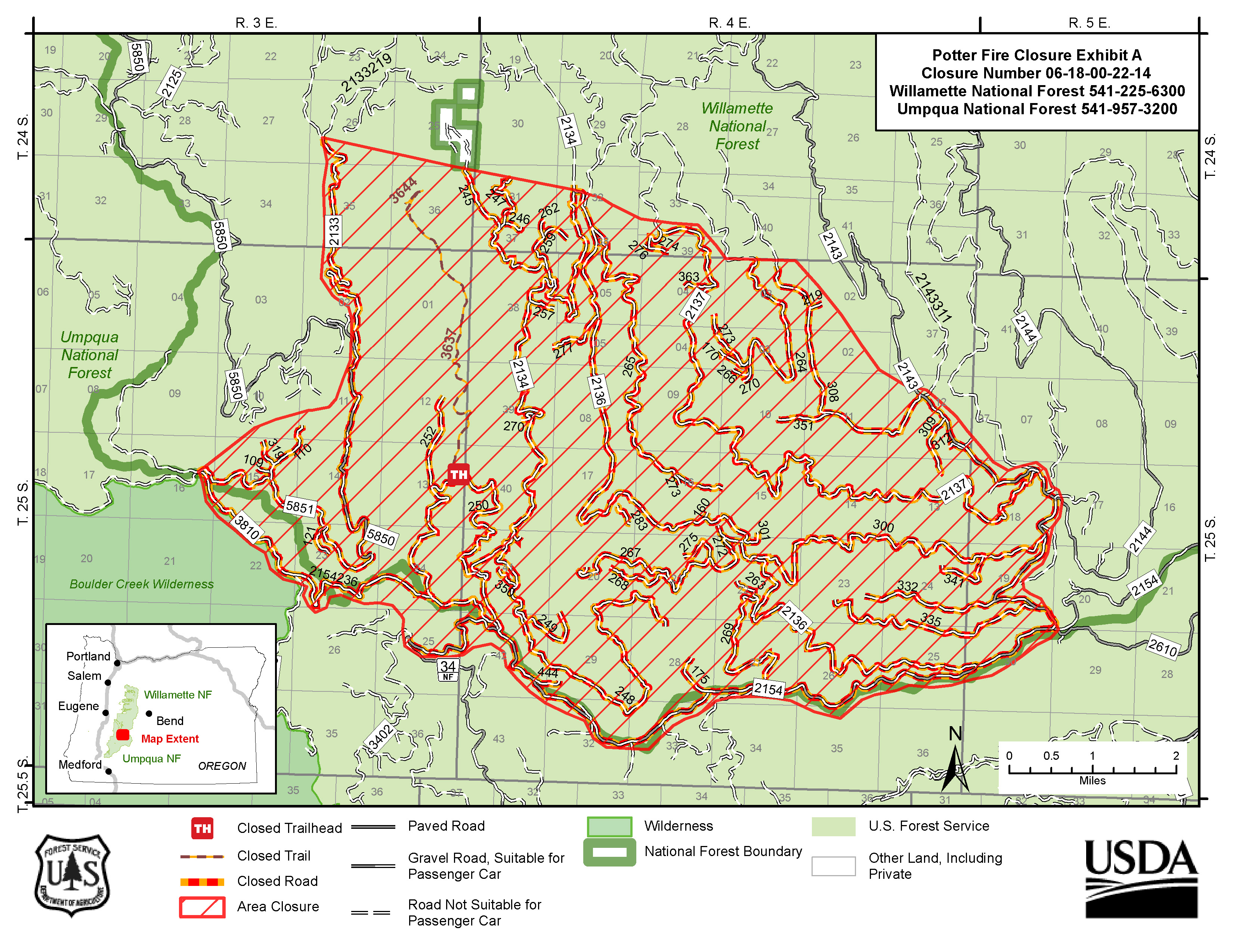
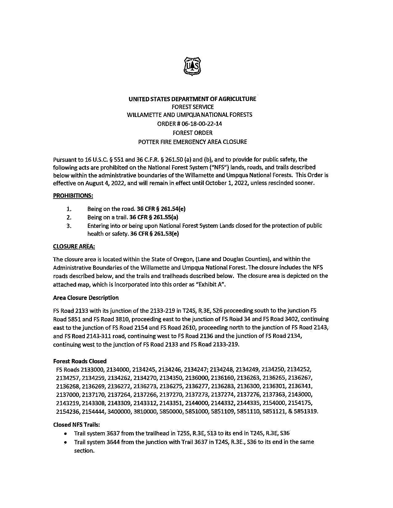
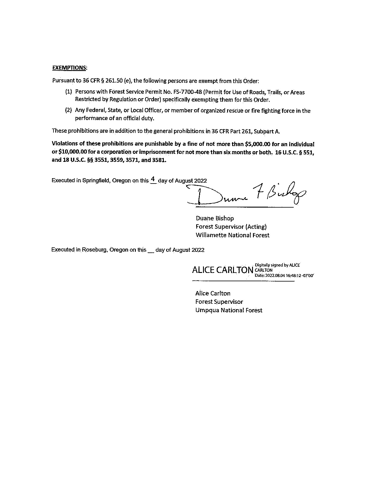
Potter Fire Closure Area
Related Incident: Potter Fire
Publication Type: Closures
Potter Fire Closure Area: http://go.usa.gov/xSGhh
862022 Windigo and Potter Fires Update
Related Incident: Potter Fire
Publication Type: News
Windigo and Potter Fires Update – August 06, 2022
Fire Information Phone Line: 206-473-8645 (8am - 7pm)
Email: 2022.Windigo@firenet.gov
Potter Fire InciWeb (Incident Website): https://inciweb.nwcg.gov/incident/8291/
Windigo Fire InciWeb (Incident Website): https://inciweb.nwcg.gov/incident/8292/
Facebook: https://www.facebook.com/Windigo-Fire-and-Potter-Fire-Information-109233838550715
For firefighter and public safety, two closure orders were finalized for areas overlapping the Umpqua, Deschutes, Willamette, and Fremont-Winema National Forests. For details about the Windigo Fire and Potter Fire closures visit: https://go.usa.gov/xSGhh.
Yesterday, fire growth was minimal for the Windigo and Potter Fires. Crews worked on an additional start that was located near the Big Swamp Fire. It is .2 acres. After an infrared flight, Big Swamp Fire is estimated to be 37 acres. Mop-up continued on the Shelter Fire. It remains under 5 acres and is fully lined with water hoses. Today, resources will continue to support suppression efforts on all fires.
Yesterday, air attack worked aggressively on the Windigo Fire with consecutive retardant drops on Windigo Butte and multiple water bucket drops throughout the perimeter. Handcrews continued to create line up the butte and dozers made progress on the western half. The fire is expected to be fully lined over the course of the next few days and crews will continue to add fire hose.
The Potter Fire continued to advance downslope. Today, all divisions will strengthen primary lines and scout for opportunities to go more direct. Air resources for both fires will include five Type 1 Helicopters and one Type 3, with one additional Type 1 in route.
Today, weather will be moderate. High temperatures may reach 83-87 degrees. West/northwest winds will be between 3-6 mph with gusts of up to 15 mph on ridge tops and valleys. Fire spotting distances may be up to ¼ - ½ mile. For information about air quality visit https://fire.airnow.gov/.
Windigo Fire
Acreage: Approx. 1,046 acres
Containment: 5%
Location: 20 miles southwest of La Pine, OR
Cause: Lightning
Potter Fire
Acreage: Approx. 167 acres
Containment: 0%
Location: 8 miles northeast of Toketee Lake
Cause: Lightning
Area closures and restrictions include:
● Pacific Crest Trail from OR Highway 138 (PCT mile 1848) to OR Highway 58 (PCT mile 1908)
● Forest Service Road (FSR) 60 from the junction with FSR 6020 to FSR 2612
● Forest Service Road (FSR) 2610 from Lemolo Dam to Calapooya Mountain
● Kelsey Horse Camp on the Umpqua and White Fish Horse Camp on the Deschutes
● Toketee Air Strip
● The Temporary Flight Restriction now covers 151,963 acres852022 Windigo and Potter Fires Update
Related Incident: Potter Fire
Publication Type: News
Windigo and Potter Fires Update – August 05, 2022
Fire Information Phone Line: 206-473-8645 (8am - 7pm)
Email: 2022.Windigo@firenet.gov
Potter Fire InciWeb (Incident Website): https://inciweb.nwcg.gov/incident/8291/
Windigo Fire InciWeb (Incident Website): https://inciweb.nwcg.gov/incident/8292/
Facebook: https://www.facebook.com/Windigo-Fire-and-Potter-Fire-Information-109233838550715
Moderate temperatures kept fire growth to a minimum on the Windigo and Potter Fires yesterday. Crews achieved 5% containment on the Windigo Fire and made progress connecting roads around the Potter Fire. Air resources were used heavily with two Type 1 Helicopters dropping water and retardant on hot spots. The Shelter Fire is now 5 acres, fully lined, and 75% contained. Resources continued to work on a lightning strike fire, now named Big Swamp Fire, a few miles west of Opal Lake. It’s 30% contained.
The Windigo Fire continues to push east towards the Pacific Crest Trail. Today, dozers and hand crews will be working from Forest Road 60 on the northeast corner of the fire and move south around the butte to prevent eastern progression. Staff on both sides of the fire will continue to lay hose, strengthen retardant lines, and monitor the perimeter.
The Potter Fire was active yesterday with slow, backing behavior—sending debris downslope. Crews were able to lay additional water hoses and sprinklers around the perimeter. Today, all divisions will be focusing on improving line and clearing roads. Air resources for both fires will include four Type 1 helicopters and one Type 3, with two additional Type 1’s in route.
Today, weather will be similar to yesterday’s conditions. High temperatures may reach 80-85 degrees. West winds will be between 5-9 mph with gusts of up to 15 mph on ridge tops and valleys. Fire spotting distances may be up to ¼ - ½ mile. For information about air quality visit https://fire.airnow.gov/.
Windigo Fire
Acreage: Approx. 1,072 acres
Containment: 5%
Location: 20 miles southwest of La Pine, OR
Cause: Lightning
Potter Fire
Acreage: Approx. 149 acres
Containment: 0%
Location: 8 miles northeast of Toketee area
Cause: Lightning
Area closures and restrictions include (a larger closure area is pending announcement):
● Pacific Crest Trail from OR Highway 138 (PCT mile 1848) to OR Highway 58 (PCT mile 1908)
● Forest Service Road (FSR) 60 from the junction with FSR 6020 on the Deschutes National Forest to FSR 2612 on the Umpqua National Forest
● Forest Service Road (FSR) 2610 from Lemolo Dam to Calapooya Mountain
● Kelsey Horse Camp on the Umpqua National Forest
● White Fish Horse Camp on the Deschutes
● Toketee Air Strip
Temporary Flight Restriction over the two fires0842022 Windigo and Potter Fires Update
Related Incident: Potter Fire
Publication Type: News
Fire Information Phone Line: 206-473-8645 (8am - 7pm)
Email: 2022.Windigo@firenet.gov
Potter Fire InciWeb (Incident Website): https://inciweb.nwcg.gov/incident/8291/
Windigo Fire InciWeb (Incident Website): https://inciweb.nwcg.gov/incident/8292/
Facebook: https://www.facebook.com/Windigo-Fire-and-Potter-Fire-Information-109233838550715
Fire growth on the Windigo and Potter Fires was minimal yesterday. Air and ground resources continued to work on initial attack addressing 14 lightning strikes and multiple spot fires outside of the fire perimeters. The start near Little Dome Rock is now being referred to as the Shelter Fire. It is currently three acres and 80% lined around the perimeter. The La Grande Hot Shot crew was able to fully contain an additional small fire.
The Windigo Fire is currently pushing east around the butte. Water hose was put along the southeast corner as well as one load of fire retardant. Eastside resources such as the Zig Zag and Baker River Hot Shots will work on primary and alternate lines to keep the fire west of the Pacific Crest Trail. Staff on the northwest side will continue to lay hose and monitor the perimeter.
Yesterday, crews on the Potter Fire continued to clear roads and create connecting lines around the perimeter. Today, resources will be focusing on improving line and scouting for ways to go more direct. Initial attack will continue in both areas with the support of two Type 1 helicopters and one Type 3 helicopter.
Fire behavior will continue to be moderate with a high temperature of 80 expected for the Windigo Fire and a high of 75 expected for the Potter Fire. West winds will be between 5-9 mph with gusts of up to 20 mph on ridge tops. Fire spotting distances may be up to ¼ - ½ mile. For information about air quality visit https://fire.airnow.gov/.
Windigo Fire
Acreage: Approx. 1,093 acres
Containment: 0%
Location: 20 miles southwest of La Pine, OR
Cause: Under Investigation
Potter Fire
Acreage: Approx. 125 acres
Containment: 0%
Location: 8 miles northeast of Toketee area
Cause: Lightning
Area closures and restrictions include:
● Pacific Crest Trail from OR Highway 138 (PCT mile 1848) to OR Highway 58 (PCT mile 1908)
● Forest Service Road (FSR) 60 from the junction with FSR 6020 on the Deschutes National Forest to FSR 2612 on the Umpqua National Forest
● Forest Service Road (FSR) 2610 from Lemolo Dam to Calapooya Mountain
● Kelsey Horse Camp on the Umpqua National Forest
● White Fish Horse Camp on the Deschutes
● Toketee Air Strip
● Temporary Flight Restriction over the two fires
Windigo and Potter Fire Area Closures and Restrictions
Related Incident: Potter Fire
Publication Type: Closures
- Pacific Crest Trail from OR Highway 138 (south end; PCT mile 1848) to OR Highway 58 (north end; PCT mile 1908)
- The east half of Diamond Peak Wilderness (only the Deschutes portion of Diamond Peak; the Willamette portion remains open)
- Timpanogas Lake Campground
- Forest Service Road (FSR) 2610 from Lemolo Dam to Calapooya Mt
- Forest Service Road (FSR) 60 from the junction with FSR 6020 in Deschutes National Forest to FSR 2612 in the Umpqua National Forest
- White Fish Horse Camp on the Deschutes
- Kelsey Horse Camp on the Umpqua
- Toketee Air Strip
- Temporary Flight Restriction over the two fires
832022 Potter Fire Update
Related Incident: Potter Fire
Publication Type: News
Windigo and Potter Fires Update – August 03, 2022
Fire Information Phone Line: 425-324-1267 (8am - 7pm)
Email: 2022.Windigo@firenet.gov
Potter Fire InciWeb (Incident Website): https://inciweb.nwcg.gov/incident/8291/
Windigo Fire InciWeb (Incident Website): https://inciweb.nwcg.gov/incident/8292/
Facebook: https://www.facebook.com/Windigo-Fire-and-Potter-Fire-Information-109233838550715
Yesterday, crews and dozers continued to build line around the Windigo and Potter Fires. Road systems are being cleared to be utilized as defensible containment lines. Air and ground resources also worked on initial attack addressing new fire starts in response to Monday night’s lightning storm. One start was located near Little Dome Rock northwest of the Potter Fire.
Today, with the arrival of more equipment and staff, crews will continue to prepare primary and alternative fire lines. On the Windigo Fire, dozer line creation will continue at the base of the butte. Handline will be cut on the steeper slopes. On the Potter Fire, crews will continue to prepare Road 2154 and scout for closer, more direct access. Initial attack will continue in both areas with the support of one Type 1 helicopter and one Type 3 helicopter arriving in the afternoon.
Fire behavior is expected to be moderate with high temperatures in the mid-80s for both fires. Southwest wind will reach 20-25 mph on ridge tops creating spotting distances of up to ¼ - ½ mile. Smoke will be visible from both fires.
Windigo Fire
Acreage: Approx. 978 acres
Containment: 0%
Location: 20 miles southwest of La Pine, OR
Cause: Under Investigation
Potter Fire
Acreage: Approx. 97 acres
Containment: 0%
Location: 8 miles northeast of Toketee area
Cause: Lightning
Area closures and restrictions include:
● Pacific Crest Trail from OR Highway 58 (north end) to OR Highway 138 (south end);
● Kelsey Horse Camp in the Umpqua National Forest;
● Forest Service Road 60 from the junction with Forest Service Road 6020 in Deschutes National Forest to Forest Service Road 2612 in the Umpqua National Forest;
● Temporary Flight Restriction over the two fires.822022 Potter Fire Update
Related Incident: Potter Fire
Publication Type: News
Windigo and Potter Fires Update – August 02, 2022
Fire Information Phone Line: 425-324-1267 (8am - 7pm)
Email: 2022.Windigo@firenet.gov
Potter Fire InciWeb (Incident Website): https://inciweb.nwcg.gov/incident/8291/
Windigo Fire InciWeb (Incident Website): https://inciweb.nwcg.gov/incident/8292/
Facebook: https://www.facebook.com/Windigo-Fire-and-Potter-Fire-Information-109233838550715
The Windigo and Potter fires began between July 30 and July 31. The fires are burning on lands managed by the USDA Forest Service, on the Umpqua National Forest and the Willamette National Forest, and adjacent to the Deschutes National Forest.
These three forests have delegated responsibility for fighting these fires to Northwest Incident Management Team 6, a Type 2 team led by Incident Commander Shawn Sheldon. The Team assumed responsibility Tuesday morning, August 2, 2022, at 6:00am.
The fires are burning primarily in a mix of timber with heavy dead and down trees. There was significant lightning activity in the area over the weekend, and combined with the triple digit heat, the occurrence of fire was not unexpected. The fires are being fought under the strategy of full suppression. Shawn Sheldon shared with firefighters that the team’s goal “is to keep the fires as small as possible” and to continue the work of the initial attack crews.
● Windigo Fire: approximately 1,200 acres and is located 20 miles southwest of La Pine, OR. The fire is currently at 0% containment with active fire behavior; firefighters are progressing toward the objective of full containment. The cause of the fire is under investigation.
● Potter Fire: approximately 85 acres (reduction in acreage due to more accurate mapping) and is located eight miles northeast of the Toketee area. The fire is currently at 0% containment with moderate fire behavior; firefighters are progressing toward the objective of full containment; it is a lightning caused fire.
Area closures and restrictions include:
● Pacific Crest Trail from OR Highway 58 (north end) to OR Highway 138 (south end);
● Kelsey Horse Camp in the Umpqua National Forest;
● Forest Service Road 60 from the junction with Forest Service Road 6020 in Deschutes National Forest to Forest Service Road 2612 in the Umpqua National Forest;
● Temporary Flight Restriction over the two fires.
Please do your part to prevent new fires. Be very careful with off-highway vehicle travel or any other potential source of ignition.
#####
Weasel Fire Area Closure
Related Incident: Weasel Fire
Publication Type: Closures
An area closure has been issued for the Weasel Fire. Please see the attached closure order and map. The closure closes the 319 road to the Weasel Cabin, but the 114 road is open until August 22nd when the road will be closed for construction unrelated to the fire. For more information on closures visit https://www.fs.usda.gov/flathead.
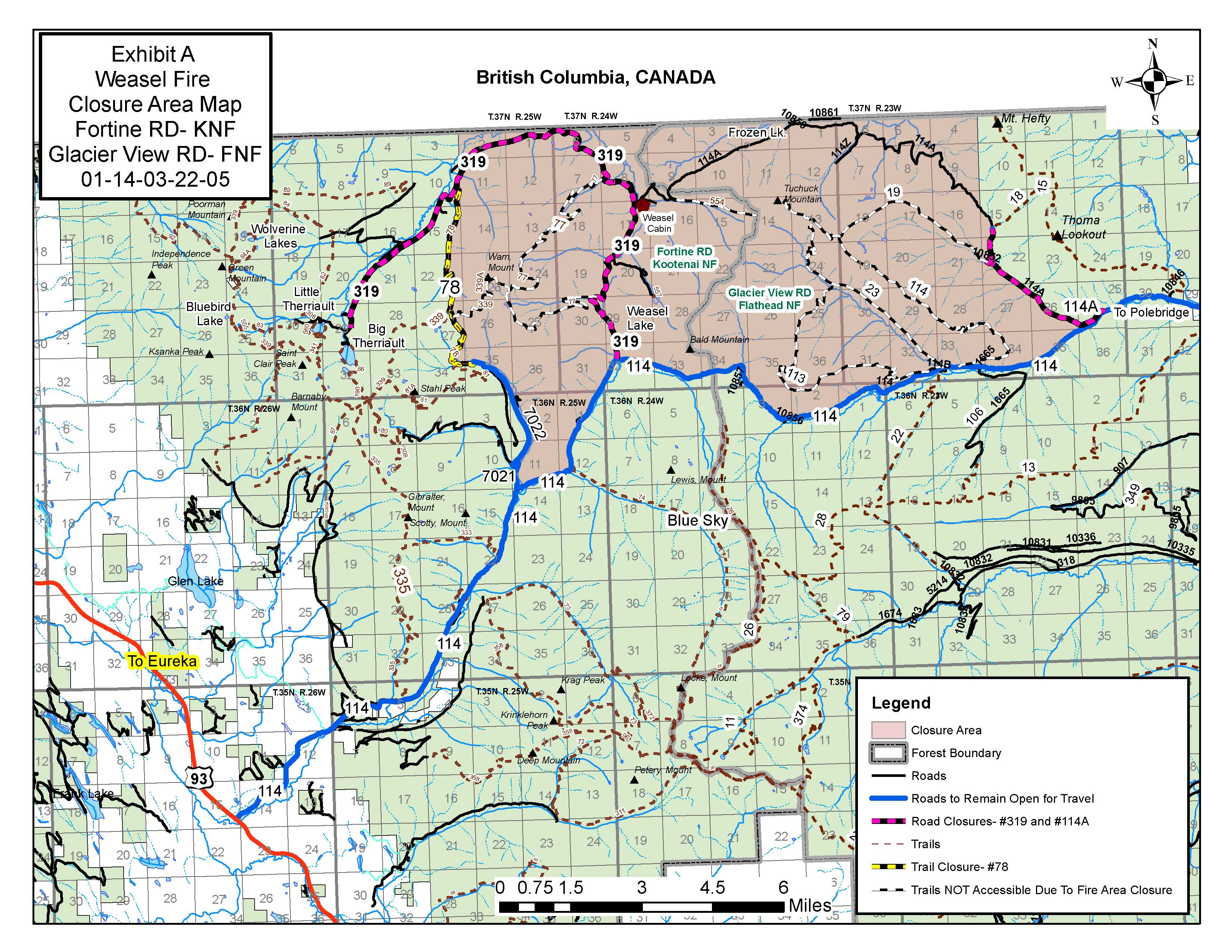
Great Divide Mountain Bike Route
Related Incident: Weasel Fire
Publication Type: Announcement
The Great Divide Mountain Bike Route is not affected by the Weasel Fire and remains open