
Incident Publication
Prescribed Fire Updates 04 30 2025
Related Incident: Mendocino NF Fall 2024/Spring 2025 Prescribed Fire Projects
Publication Type: News
Today firefighters will conduct a pile burn at Wells Cabin, located in the northern part of the forest below Anthony Peak. Some smoke may be visible in the campground, but the piles are small and should consume relatively quickly. Prescribed fire operations are carefully monitored, and firefighters will conduct patrols following burning operations.
Prescribed Fire Updates 04 18 2025
Related Incident: Mendocino NF 2023 RX Fire Projects
Publication Type: News
This week Mendocino National Forest firefighters completed 3.5 acres of burning at the Chico Seed Orchard. Also this week, firefighters from the Upper Lake and Covelo Ranger Districts assisted on a prescribed burn led by Bureau of Land Management in the Black Forest near Soda Bay Road in Lake County.
This collaboration included fire resources from BLM California Fire Information, CAL FIRE Sonoma-Lake-Napa Unit and Tribal EcoRestoration Alliance in an effort to reduce hazardous fuels and protect communities nestled in the unique forest ecosystem of Mt. Konocti, including Buckingham, Riviera Heights and Riviera West.
“Everyone is all in, making sure that this burn could be carried out when it’s safe. My profound gratitude for all the partners coming together, identifying that this project needed to happen and that it needed to happen this spring,” said Jessica Pyska, Lake County District 5 Supervisor while on scene at the Black Forest prescribed burn.
Over the next several weeks, MNF firefighters will look for opportunities to continue pile burning in the North Shore Restoration project on Long Valley Ridge, pending favorable weather conditions, burn windows and resource availability. The units are slash piles in areas that will be replanted with trees. Potentially 10 acres are planned for prescribed burning along Long Valley Ridge above Lakeview Campground.
Prescribed Fire Updates 04 24 2025
Related Incident: Mendocino NF Fall 2024/Spring 2025 Prescribed Fire Projects
Publication Type: News
With incoming cooler temperatures and possible precipitation today and tomorrow, firefighters on the Upper Lake & Covelo Ranger Districts are attempting to burn 16 acres of roadside piles in the North Shore Restoration project along Long Valley Ridge. The units are slash piles that will be replanted.
Resources from North Shore Hogback Ridge Fuels Crew and CAL FIRE Sonoma-Lake-Napa Unit are assisting. Smoke impacts should be minimal. After ignitions are complete, firefighters will patrol the units over the weekend and mop-up any remaining heat next week.
Prescribed Burn Near Dolores Completed 04 28 2025
Related Incident: 2025 San Juan National Forest Prescribed Fire Program
Publication Type: Announcement
The Dolores Ranger District conducted a prescribed burn in the Boggy Draw area off Forest Service System Road 532 (Cottonwood Road), approximately 16 miles Northeast of Dolores on Tuesday April 29th. Fire personnel continue to patrol the burn area. Residents may continue to see smoke in the coming days as unburned fuel is consumed.
Find updates on either the forest Facebook or Twitter accounts, links below.
The forests in Southwest Colorado are part of a fire-adapted ecosystem, which historically experienced frequent, low intensity fires on a large scale. Prescribed fire replicates that fire regime and increases the area on our landscape that has been burned at low and moderate conditions.
April 26 Prescribed Fire Operations 04 26 2025
Related Incident: Lolo National Forest Prescribed Fire Operations
Publication Type: Announcement
Fire officials on the Lolo National Forest may implement prescribed fire operations today, as weather and fuels conditions allow.
Plains/Thompson Falls Ranger District: Firefighters plan to conduct up to 15 acres of understory burning on the 2 Short units 6 miles west of Thompson Falls. Smoke may be visible from Thompson Falls.
For more information visit: https://inciweb.wildfire.gov/incident-information/mtlnf-lolo-national-forest-prescribed-fire-operations.
UPDATE Prescribed Fire Operations April 25 04 25 2025
Related Incident: Lolo National Forest Prescribed Fire Operations
Publication Type: Announcement
UPDATE
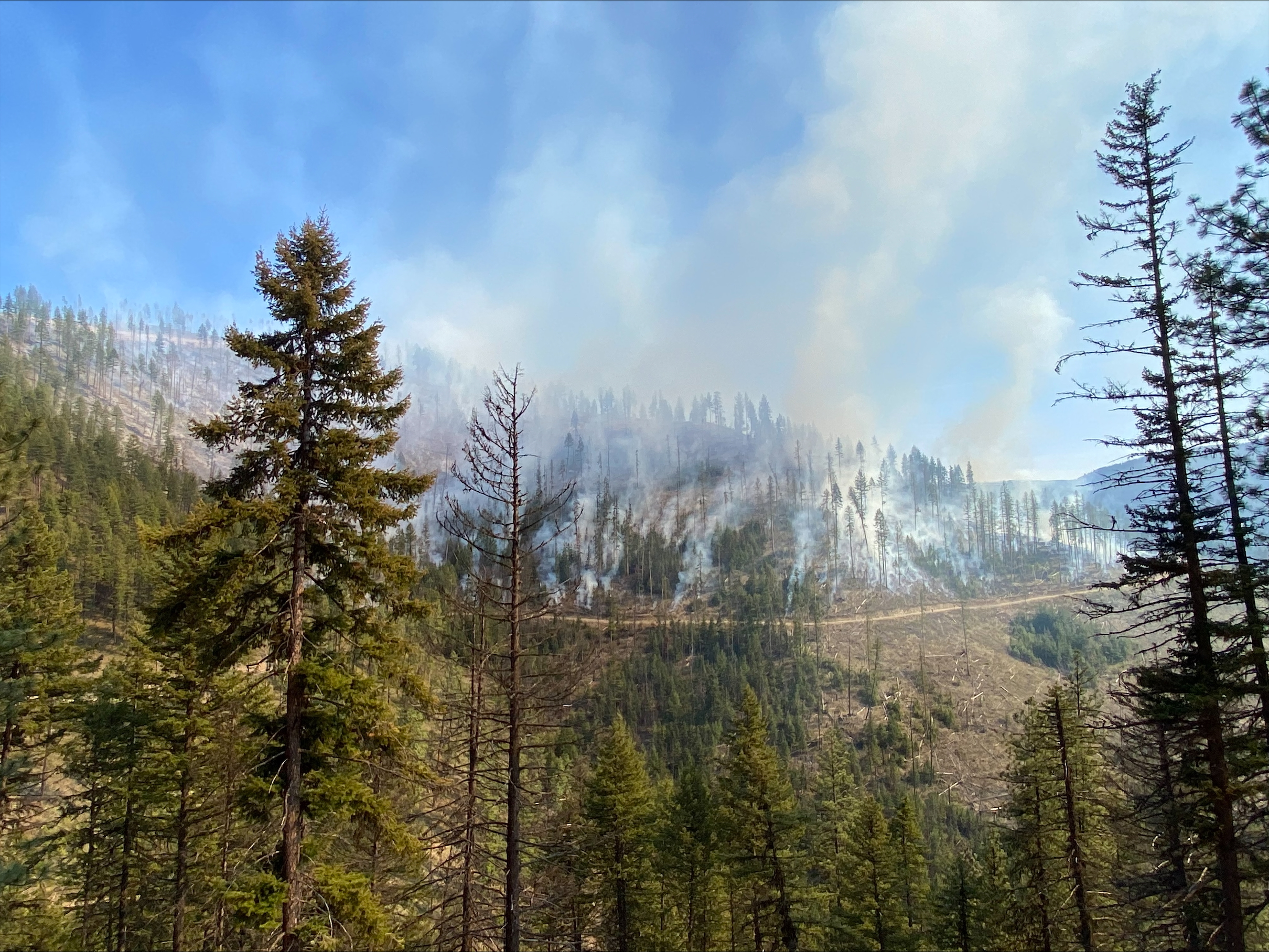
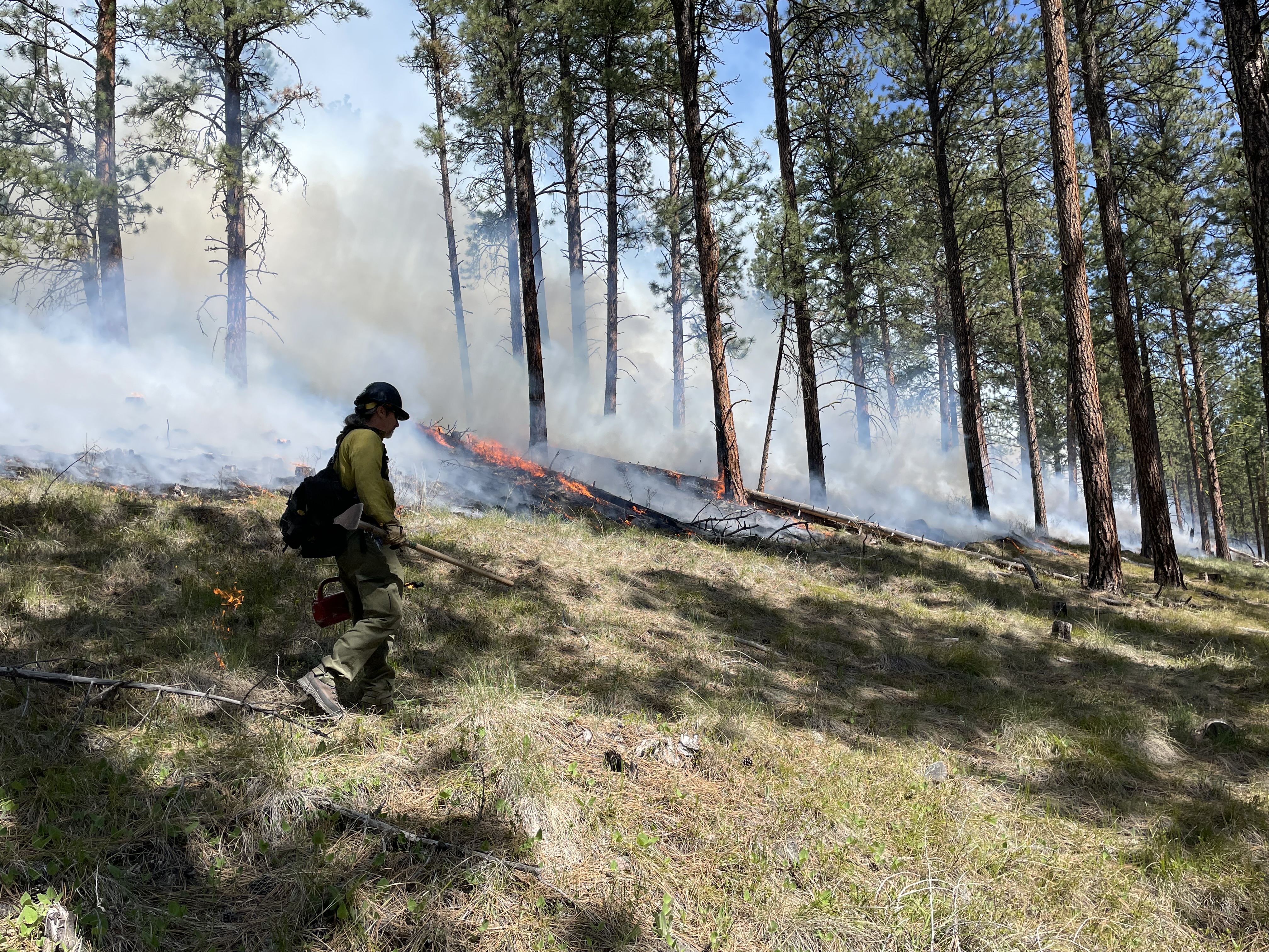
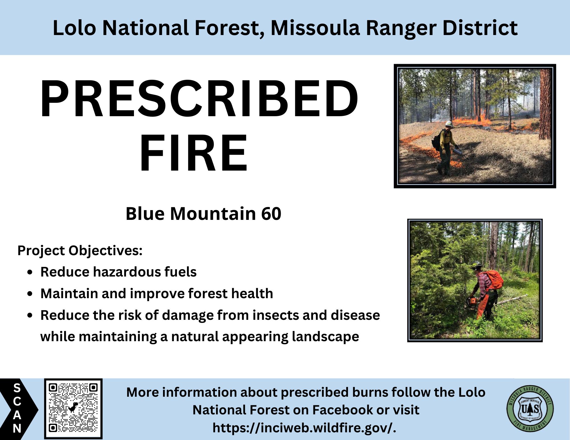
Missoula Ranger District- Blue Mountain: Firefighters completed ignitions on the Blue Mountain prescribed fire this afternoon (April 25). Smoke will likely be visible from Blue Mountain Road, Missoula, and surrounding area. Smoke may pool in lower elevations and along roadways during the evenings and early morning hours; impacts are expected to dissipate in a few days. Firefighters will remain on scene over the next few days.
Fire officials on the Lolo National Forest may implement prescribed fire operations today, as weather and fuels conditions allow.
Missoula Ranger District: The Missoula Ranger Districts plans to burn up to 43 acres on the Blue Mountain Unit 60, adjacent to Forest Service Road 365 and Blue Mountain Road (see map). This understory prescribed burn is part of the Wildfire Adapted Missoula project.
The prescribed burn objective is to reduce hazardous fuels by helping to reduce the risk of severe, wildfires and provide long-term ecosystem health, and help improve wildlife habitat and native plant regeneration.
All burning will be weather and fuel condition dependent. If ignition takes place, there is potential the burning could limit public access in these areas. For public safety, recreationists are asked to be aware of fire crews and vehicles in all prescribed fire areas. Prescribed fire signs will be posted near Maclay Flats on Blue Mountain Road, at the junction of Blue Mountain Road and the locked gate at Forest Service Road 365, and at the Blue Mountain trailhead.
Please avoid traveling in proposed prescribed burn units as well as trails and roads directly adjacent to the units. Please exercise caution as roads and trails could be temporarily impacted by low intensity fire and smoke. Smoke may be visible from Highway 93, Blue Mountain, and surrounding area.
Plains/Thompson Falls Ranger District: Firefighters plan to conduct up to 85 acres of understory burning on the 2 Short units 6 miles west of Thompson Falls. Smoke may be visible from Thompson Falls.

HAOE LEAD Fire Daily Update Thursday April 24 2025 04 25 2025
Related Incident:
Publication Type: News
Today April 24, 2025 will be our last update. We will be turning the fire back to the locals as of today. We would like to thank Graham County for all the help and support.
Size: 3,103 acres Location: 7 miles west of Robbinsville, NC. County: Graham
Start Date: April 12, 2025 Cause: Lightning Containment: 57% Total Personnel: 113
ROBBINSVILLE, N.C., April 24, 2025 - The Haoe Lead Fire is located within and adjacent to the Joyce Kilmer-Slickrock Wilderness on the Cheoah Ranger District of the Nantahala National Forest, approximately 7 miles west of Robbinsville, North Carolina, and 2 miles west of Lake Santeetlah. The fire is entirely on National Forest System lands, and no private lands or structures are threatened. No evacuations are in effect or anticipated. The fire is being managed under a full suppression strategy using existing barriers and a combination of direct and indirect tactics. This fire is predominantly within the fire scar of the 2016 Maple Springs Fire, in steep and rugged terrain.
Yesterday’s Activities – Damp and rainy conditions kept fire activity minimal. Crews patrolled the fire perimeter area and extinguished a small number of smoldering heavy fuels. They completed the removal of all the hose, pumps and other water handling equipment from the fire area. Firefighters also removed fire-weakened and dead trees (snags) near recreation facilities and roads. In addition, firefighters began suppression repair work to naturalize fire lines.
Ongoing Activities – Ongoing rain for the remainder of the week will continue to diminish fire activity throughout the area. Crews will continue to patrol and monitor fire lines, roads, and the fire perimeter and extinguish any smoking or smoldering heavy fuels. Suppression repair work will continue to naturalize the handlines and dozer lines that have been constructed and return them to their pre-fire state. The number of firefighters and resources assigned to the fire will continue to decrease as fire containment increases.
Transfer of command of the Haoe Lead Fire from the Southern Area Gray Team back to local Cheoah Ranger District personnel occurred on Thursday, April 24.
Weather and Smoke – The fire has received approximately 1.5 inches of rain since Monday, April 21, which has greatly aided in fire suppression. The wet weather pattern will continue with at least scattered showers and thunderstorms through Saturday, April 26. Smoke from the fire may sometimes be visible from area roads and communities. Air quality information can be found at https://fire.airnow.gov/.
Closures - The USDA Forest Service closure order for the area around the Haoe Lead Fire remains in effect for the safety of both the public and fire personnel. Fire managers will assess conditions daily to determine when this closure can be reduced or lifted. The closed area includes the North Carolina portion of the Joyce Kilmer-Slickrock Wilderness and non-Wilderness lands in the Santeetlah Road area.
Most trails in the Joyce Kilmer-Slickrock Wilderness remain closed, including Joyce Kilmer Memorial Loop. Several of these closed trails are sections of the Benton MacKaye Trail. In addition, Santeetlah Road and the Big Santeetlah Creek area are closed to all public use.
Aircraft and Drone Restrictions – Firefighting aircraft continue to assist in suppression efforts. Private pilots should continue to avoid the fire area. Public drone use near the fire remains prohibited due to the risk of interference with aviation assets. If you fly, we can’t.
This is the final Daily Update for the Haoe Lead Fire. Please refer to the Facebook page and website of the National Forests in North Carolina, or the fire information phone line, for current information.
Camp Underburn Update 04 23 2025
Related Incident:
Publication Type: Announcement
U.S. Forest Service fire resources completed ignitions on 20 acres of the Camp Underburn today, April 23. Over the past two days, 93 acres of fuels reduction work has been completed on the project. While no further ignitions are currently planned, fire staff will continue to monitor the project area over several days to weeks to ensure incident and public safety objectives are met.
Prescribed Fire Operations April 24 and 25 04 24 2025
Related Incident: Lolo National Forest Prescribed Fire Operations
Publication Type: Announcement
Fire officials on the Lolo National Forest may implement prescribed fire operations today and tomorrow, as weather and fuels conditions allow.
April 24
Superior Ranger District: Firefighters will burn up to 10 acres in the Second Chance project area, 4.6 miles north of Lozeau in the Fish Creek drainage on Forest Service Road 7893 (see map below). Minimal smoke impacts are anticipated; however, smoke may be visible from Interstate 90 in the Lozeau area.
April 25
Missoula Ranger District: The Missoula Ranger Districts plans to burn up to 43 acres on the Blue Mountain Unit 60, adjacent to Forest Service Road 365 and Blue Mountain Road (see map). This understory prescribed burn is part of the Wildfire Adapted Missoula project.
The prescribed burn objective is to reduce hazardous fuels by helping to reduce the risk of severe, wildfires and provide long-term ecosystem health, and help improve wildlife habitat and native plant regeneration.
All burning will be weather and fuel condition dependent. If ignition takes place, there is potential the burning could limit public access in these areas. For public safety, recreationists are asked to be aware of fire crews and vehicles in all prescribed fire areas. Prescribed fire signs will be posted near Maclay Flats on Blue Mountain Road, at the junction of Blue Mountain Road and the locked gate at Forest Service Road 365, and at the Blue Mountain trailhead.
Please avoid traveling in proposed prescribed burn units as well as trails and roads directly adjacent to the units. Please exercise caution as roads and trails could be temporarily impacted by low intensity fire and smoke. Smoke may be visible from Highway 93, Blue Mountain, and surrounding area.
Plains/Thompson Falls Ranger District: Firefighters plan to conduct up to 85 acres of understory burning on the 2 Short units 6 miles west of Thompson Falls. Smoke may be visible from Thompson Falls.
HAOE LEAD Fire Daily Update Wednesday April 23 2025 04 23 2025
Related Incident:
Publication Type: News
Size: 3,103 acres Location: 7 miles west of Robbinsville, NC. County: Graham
Start Date: April 12, 2025 Cause: Lightning Containment: 29% Total Personnel: 124
ROBBINSVILLE, N.C., April 23, 2025 - The Haoe Lead Fire is burning within and adjacent to the Joyce Kilmer-Slickrock Wilderness on the Cheoah Ranger District of the Nantahala National Forest, approximately 7 miles west of Robbinsville, North Carolina, and 2 miles west of Lake Santeetlah. The fire is entirely on National Forest System lands, and no private lands or structures are threatened. No evacuations in effect or anticipated. The Southern Area Gray Team is managing this fire under a full suppression strategy using existing barriers and a combination of direct and indirect tactics. The fire is burning hardwood leaf litter and shrubs in steep and rugged terrain, and much is within the fire scar of the 2016 Maple Springs Fire.
Yesterday’s Activities – Significant precipitation fell across the fire area beginning Monday evening and continued throughout the day Tuesday, with rain gauges on the fire recording amounts of 0.75 inches to more than an inch. The fire did not grow in size on Tuesday. Fire activity was minimal throughout the day, with only scattered heavy fuels and stumps smoking. Fire crews patrolled roads and fire lines along and near the fire perimeter.
Today’s Activities – Damp and rainy conditions will continue today and will keep fire activity minimal. Significant additional rainfall is expected. Firefighters will continue to patrol and monitor the fire lines and fire perimeter for any smoldering or smoking heavy fuels, logs and stumps. Crews will remove hoselays and other water handling equipment from the area near the Joyce Kilmer Memorial Loop Trail (TR 43) and begin suppression repair work to naturalize handlines and dozer lines on the east and south portions of the fire. Some resources are being reassigned to other wildfires.
Weather and Smoke – Cloudy and rainy weather will continue today, with scattered thunderstorms possible. Additional rainfall accumulations of more than an inch are possible. Smoke from the fire will be minimal today. Air quality information can be found at https://fire.airnow.gov/.
Closures - The USDA Forest Service closure order for the area around the Haoe Lead Fire remains in effect for the safety of both the public and fire personnel. The closed area includes the North Carolina portion of the Joyce Kilmer-Slickrock Wilderness and non-Wilderness lands in the Santeetlah Road area.
Most trails in the Joyce Kilmer-Slickrock Wilderness remain closed, including Joyce Kilmer Memorial Loop. Several of these closed trails are sections of the Benton MacKaye Trail. In addition, Santeetlah Road and the Big Santeetlah Creek area are closed to all public use.
Aircraft and Drone Restrictions – The Temporary Flight Restriction (TFR) for the area around the fire has been lifted. Firefighting aircraft are still active on the Haoe Lead Fire. Public drone (UAS) use near the fire remains prohibited due to the risk of interference with aviation assets. If you fly, we can’t.