
Incident Publication
Ellis Fire in Patrol Status
Related Incident:
Publication Type: Announcement
Notice: the incident management team has put the Ellis Fire in patrol status as of August 1, 2021. Firefighters will continue to monitor this fire as necessary, but additional growth is unlikely. Unless the status changes, this will be the last post for the Ellis Fire.
Preevacuation Order Rescinded
Related Incident:
Publication Type: Announcement
According to Meagher County Sheriff Jon Lopp, the pre-evacuation order for the Smith River corridor from Camp Baker to the confluence with Blacktail Creek has been rescinded.
Silcott Fire Update
Related Incident:
Publication Type: News
Silcott Fire

Fire Information Number: (509) 731-4074
Email: sewaimtpio@gmail.com
InciWeb site: https://inciweb.nwcg.gov/incident/7626/
Incident Commander: Leonard Johnson
Public Information: Cole Massey (Lead), Grace DeBusschere
UPDATE: 8:30AM July 9, 2021
Incident Summary: Southeast WA Type 3 Incident Management Team 2 is working in cooperation with Asotin County Fire District 1, the Washington State Patrol-Fire Marshal’s Office, the Bureau of Land Management (BLM), WA DNR, US Forest Service and the Asotin County Sheriff and Emergency Management to manage the response to the Silcott fire, which started in the area of Silcott Grade Road west of the city of Clarkston.
Containment: 10% (Silcott fire)
Size: 8,633 acres (Silcott fire)
Start Date: 7/7/2021
Resources: 4 Strike teams
4 single engines additionally
5 Hand crews
1 Tender
2 Dozers
Known structures lost: None on Silcott
Structures threatened: 150
Transition: At 6:00 am this morning, Type 2 Northwest Incident Management Team 7 assumed command of the Dry Gulch fire. Southeast WA Type 3 Incident Management Team 2 continues to manage the response to the Silcott fire. From this point onward, this page will only provide updates on the Silcott fire.
Last night: The Silcott Fire remained within its existing perimeter last night. Resources focused on securing the edge of the fire by improving containment lines, securing and mopping up around structures, and building control lines to complete the perimeter around the fire.
Today: We do not expect the fire to leave its current borders. Crews will secure containment lines, mop up, and patrol for hot spots.
Evacuations: Level 3 (Go Now) evacuations are in place for residences on Asotin Creek Road west of the Cloverland fork. Level 2 (Get Set) evacuations are in place for Cloverland Road and streets off of Cloverland Road, as well as the Harlow Ridge area. In Clarkston Heights, areas south of Peola Road and Critchfield Road intersections to Quail Ridge/Swallow’s Nest Golf Course are at a Level 2.
Shelter: Evacuees are able to take shelter at Lincoln Middle School in Clarkston. The shelter is being staffed by Red Cross Volunteers. Livestock and large animals can be evacuated to the Livestock Market at 3200 E Main St, Lewiston, ID 83501.
Web Updates: The InciWeb site (https://inciweb.nwcg.gov/incident/7626/) and Facebook page (https://www.facebook.com/sewaimt) are updated as information becomes available.
Evacuation Levels Information Release
Related Incident:
Publication Type: News
INFORMATION RELEASE: 2:30PM July 9, 2021
The Asotin County Sheriff’s Office, Fire Department, Public Works, and Emergency Services have collaborated to release the following updates to evacuation zones due to wildfires:
Evacuations:
Level 3 (Go Now) are still in place for residences on Asotin Creek Road west of the Cloverland fork. This also includes Back Road and Bowman Road.
Level 2 (Get Set) evacuations are in place for Cloverland Road and streets off of Cloverland Road, as well as the Harlow Ridge area, George Creek Road, and Hostetler Road.
Level (Be Ready) 1: In Clarkston Heights, the areas south of Critchfield Road until Morgan Road and Maguire Gulch are now at Level 1. Peola Road, Silcott Wye Road, and the surrounding roads are also at a Level 1.
Shelter: Evacuees are able to take shelter at Lincoln Middle School in Clarkston. The shelter is being staffed by Red Cross Volunteers. Livestock and large animals can be evacuated to the Livestock Market at 3200 E Main St, Lewiston, ID 83501.
Web Updates: The InciWeb site (https://inciweb.nwcg.gov/incident/7626/) and Facebook page (https://www.facebook.com/sewaimt) are updated as information becomes available.
Morning Update 71021
Related Incident:
Publication Type: News
Incident Summary: Southeast WA Type 3 Incident Management Team 2 is working in cooperation with Asotin County Fire District 1, the Washington State Patrol-Fire Marshal’s Office, the Bureau of Land Management (BLM), WA DNR, US Forest Service and the Asotin County Sheriff and Emergency Management to manage the response to the Silcott fire, which started in the area of Silcott Grade Road west of the city of Clarkston.
Containment: 80%
Size: 8,633 acres
Start Date: 7/7/2021
Resources: 25 Engines
1 Crew
5 Water Tenders
Known structures lost: None
Structures threatened: 150
Last night: Southeast Washington Type 3 Incident Management Team 2, in command of the response to the Silcott fire, co hosted a community meeting at the Asotin County Fire District #1 fire station, alongside the team in command of the Dry Gulch fire. At the meeting, members of the command teams for both fires, along with local agencies, shared about their progress and strategies for the fires. You can view the recorded live stream of the community meeting on the Facebook page for Asotin County Fire District #1 (https://fb.watch/6Fnj48Y42N/).
Today: The Silcott fire is now 80% contained and resources on the line are focused on mop up. Overnight the fire remained within the existing perimeter. Crews returned to the fireline this morning to continue with patrol and mop-up before returning the fire to Asotin County Fire Protection District 1. Southeast Washington Type 3 Incident Management Team 2 is releasing resources to the Dry Gulch fire and back to their home units. With that, the team prepares to hand off public information updates to local agencies. If you have a question about evacuations or the Silcott fire, contact your local Fire Department, Emergency Services, or Sheriff’s Office.
Evacuations: Level 3 (Go Now): Asotin Creek; Level 2 (Get Set): Cloverland
Level (Be Ready) 1: Clarkston Heights; Peola Road
Shelter: Lincoln Middle School in Clarkston. Large animals: Livestock Market at 3200 E Main St, Lewiston, ID 83501.
Road closure for the St Joe River Rd NF50
Related Incident:
Publication Type: Closures
The St. Joe River Rd, NF-50, is currently closed due to active fire and falling debris between Bluff and Bruin Creek (approx mi 68-72). The closure is a few miles down river from Conrad Crossing Campground. Alternative access to the upper St. Joe River area is over Gold Pass. The Little Joe Road (FS 282) from I-90 at St. Regis, MT connects with highway 50 at Gold Pass (the ID/MT state line). The Little Joe Road is a gravel road. This road closure has been issued by the Shoshone Co Sheriff. Any updates to these fires or road closure will be posted here as soon as available. In the meantime, check out the alternate routes map.
Please see the 'Closures' tab for other area closures.
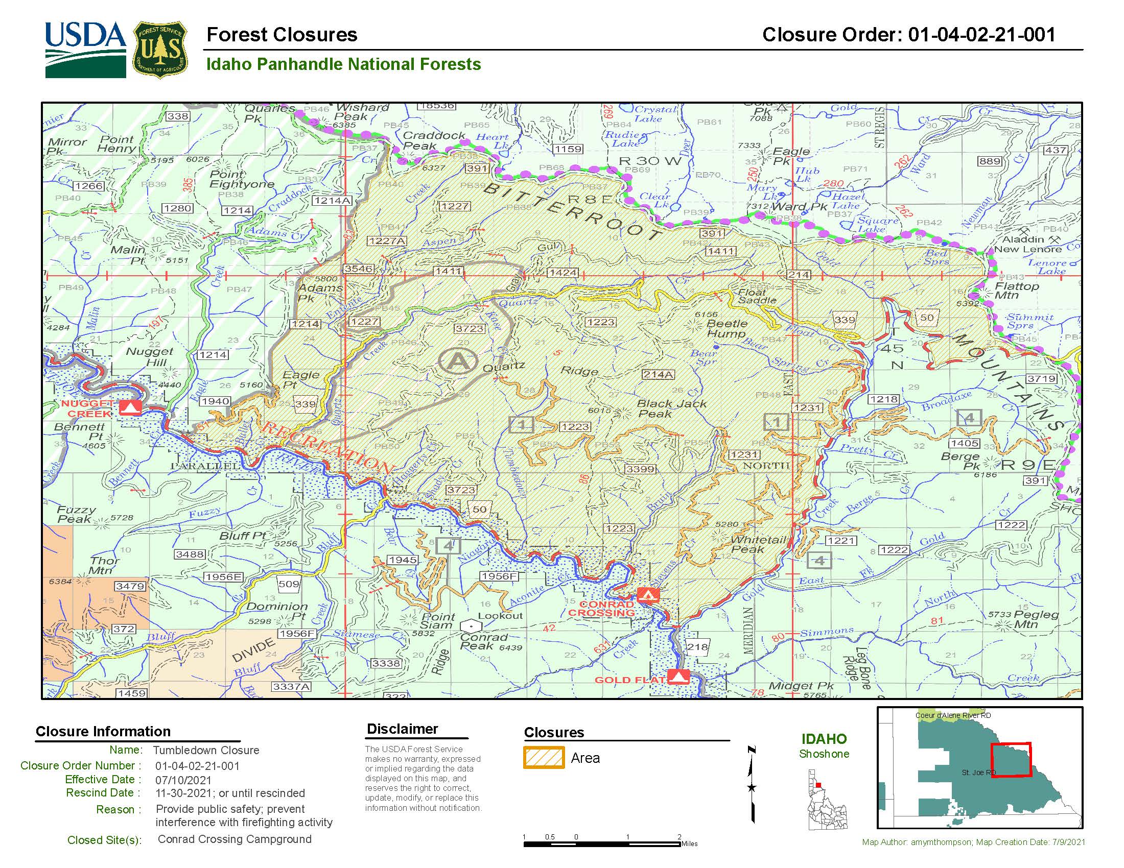
Tumbledown Closure
Related Incident:
Publication Type: Closures
AREA CLOSURE DESCRIPTION:Beginning on Highway 50 (Township 17N, Range 31W section 35, where Highway 50 leaves section 35 to the west) proceeding northeast to Eagle Point. Proceed north along the ridge to Adams Peak. Proceed northeast to where Trail 83 meets FSR214. Then, proceed north on Trail83 to the intersection of FSR 391 on the Bitterroot Divide. Then proceeding on FSR 391generally southeast until FSR 391 intersect with Highway 50. Then proceeding west on highway50 towards the St. Joe River. Then proceed downriver along Highway 50 to the junction of Highway 50 and FSR 1214, the starting point. Trail 3355, Trail 83, FSR 1214, FSR 391, and Highway 50 are not included in the closure, but Highway 50 between Bluff and Bruin Creek is closed by County Sheriff Authority .
See Reference Map in the link below for further information
Being on the following roads:
• FSR 1940: From its intersection at the 1214 to its terminus
• FSR 339: From its intersection with Highway 50 to the intersection of Highway 50
• FSR 1223: From its junction at Highway 50 to its terminus on Quartz Ridge
• FSR 214: At its junction with FSR 391 to Float Saddle
• FSR 3546
• FSR 1227
• FSR 1411
• FSR 3399
• FSR 3723
• FSR 1227A
Being on the following Trails:
• Trail 1424
• Trail 1411
• Trail 1223
• Trail 1226
• Trail 3723
• Trail 3459
• Trail 1231
• Trail 214A
Being in Campground:
Conrad Crossing
Simmons Ridge Fire Closure
Related Incident:
Publication Type: Closures
For public and firefighter safety in the vicinity of the Simmons Ridge Fire, the following campsite, road and trails have been closed until further notice.
CLOSED CAMPSITE:Gold Flat Campsite (T16N, R30W, Section 23), as shown in Attachment A.CLOSED TRAILS:Trail 74: From its junction at FSR 1216 to its junction at Trail 78, 5.8 miles total.Trail 78: From its junction at Highway 218 to its junction at Forest Service Road (FSR) 346, 8.5 miles total.Trail 284: From its junction at Highway 218 to its junction at Trail 78, 4.7 miles total. Trail 478: From its junction at Highway 218 to its junction at Trail 284, 3.6 miles total.As shown on the attached map, attachment A.CLOSED ROAD:FSR 1216: From its junction at Highway 218 to its terminus. As shown on the attached map.
Simmons Ridge Fire Closure Map
Stateline Fire Complex Daily Update 72021
Related Incident:
Publication Type: News
St. Joe July Lightning Fires now managed as Stateline Complex
Stateline Complex Fire Daily Update July 20, 2021
Acres: 1,789 acres
Cause: Lightning
Containment: 0%
Start Date: Wednesday, July 7, 2021
Location: 47.17 latitude, -115.442 longitude
Fuels: Mixed conifer
Announcement: Today, Tuesday, July 20, 2021, the Type 2 Southwest Area Incident Management
Team (IMT) 5, led by Incident Commander Mark Bernal, assumed command of the St. Joe July Lightning Fires incident, now called the Stateline Complex Fire. The IMT will continue working closely with the Idaho Panhandle National Forests (NF), as well as the Lolo NF, throughout the incident. A road closure remains in effect on St. Joe River Rd, NF-50 between Bluff and Bruin Creek.
Overview: On July 7, 2021, a thunderstorm system moved through the Idaho Panhandle. Due to record drought conditions and unseasonably high temperatures, the storm system resulted in a high number of lightning-caused wildfires. With over 30 fires identified, the Idaho Panhandle National Forest (IPNF) began initial attack and identified opportunities to group and manage multiple fires within several complex incidents.
As of the evening of July 19, the St. Joe July Lightning incident was renamed to Stateline Complex and includes 12 fires identified in the initial assessment and 2 others observed within the last 24 hours, with the Dolly Creek Fire (451 acres) and Tumbledown Fire (1,338 acres) standing as the largest fires burning within the complex.
Fire Update: On Monday, July 19, SWA IMT personnel began assessing the situation across the Complex including conducting flight operations and utilizing scouting crews on the ground. Fire activity was low, with minimal growth, however with the high number of active fires still burning, additional resources are pending as crews continue to assess the situation to determine the best path forward.
The area is under a Red Flag Warning through Wednesday, July 21 and the likelihood of dry thunderstorms will persist throughout the early half of the week.
Closures: St. Joe River Rd, NF-50 between Bluff and Bruin Creek, per County Sheriff Authority; FSR 1216: From its junction at Highway 218 to its terminus; Gold Flat Campsite (T16N, R30W, Section 23); additionally, several trails and areas within the St. Joe Ranger District. The latest information is available at the Inciweb link, below.
Restrictions: Stage II Fire Restrictions are in effect for the Coeur d’Alene and Grangeville areas. Check the links below for further information.
More Information:
Inciweb: https://inciweb.nwcg.gov/incident/7627/
Idaho Panhandle National Forest Facebook: https://www.facebook.com/USFSIPNF
Lolo National Forest: https://www.facebook.com/USFSIPNF
Fire Restriction Information: http://www.idahofireinfo.com/ and https://www.mtfireinfo.org/
Road Closure Information: See the Inciweb link above for the latest road and area closures
Stateline Complex Fire Daily Update 72121
Related Incident:
Publication Type: News
Public Information & Media Phone Line (8am – 8pm MDT): 406-818-5200
Email: 2021.stateline@firenet.gov
Steady, Moderate Fire Growth with Persistent Red Flag Warning
Stateline Complex Fire Daily Update July 21, 2021
Acres: 2,147 acres
Personnel: 205
Cause: Lightning
Containment: 0%
Start Date: Wednesday, July 7, 2021
Location: 6.5 miles SW of St. Regis, MT
Fuels: Mixed conifer
Announcement: Several closures are in effect and a temporary flight restriction is in place across the entire Complex. Highway 50 remains closed between Bluff and Bruin Creek as well as Gold Flat Campsite and several trails within the St. Joe Ranger District.
Overview: The Stateline Complex comprises 13 fires within its boundary, with Tumbledown and Dolly Creek continuing to be the largest. The complex as a whole has a full suppression, values-driven strategy that utilizes a mix of tactics including direct, indirect and point protection. The remote location, steep terrain, limited access, distance between fires, and lack of suppression resources is challenging firefighting efforts and logistical support.
Fire Update: Fires within the Stateline Complex are burning at a slow, steady rate of speed in mixed fuels and forest types including sub-alpine fir in higher elevations with a transition down to pine, mixed conifer, and brush fuels in lower elevations. Crews have begun indirect suppression tactics including building fire line and conducting some fuel mastication work. Personnel anticipate varying terrain to assist in slowing and stalling the fires’ spread, however critically dry fuels still hold a high potential for fire activity. Crews will continue to monitor fire activity and prep indirect firelines, while providing point protection as needed for values at risk including the I90 corridor, multiple communities in Idaho (Avery) and Montana (DeBorgia, Haugan, St. Regis, Superior), and some timber management areas, among others.
Weather: On Wednesday, July 21, 2021, a weak but dry cold front will generate gusty south to west winds with gusts up to 25 mph. By Thursday, temperatures will increase, with hot and dry conditions continuing into the weekend. The area remains under a Red Flag Warning through the evening of Wednesday, July 21 and the likelihood of dry thunderstorms will persist through mid-week.
Closures: As of July 20, 2021, a temporary flight restriction is in effect for the entirety of the Stateline Complex area. The following also remain closed: St. Joe River Rd/Highway 50 between Bluff and Bruin Creek; FSR 1216 from its junction at Highway 218 to its terminus; Gold Flat Campsite (T16N, R30W, Section 23); several trails and areas within the St. Joe Ranger District. The latest information is available at the links below.
Restrictions: Stage II Fire Restrictions are in effect for the Coeur d’Alene and Grangeville dispatch areas.
More Information:
Inciweb: https://inciweb.nwcg.gov/incident/7627/
Idaho Panhandle National Forests Facebook: https://www.facebook.com/USFSIPNF
Lolo National Forest: https://www.facebook.com/USFSIPNF Fire Restriction Information: http://www.idahofireinfo.com/ and https://www.mtfireinfo.org/
Area Closure Information: https://www.fs.usda.gov/alerts/ipnf/alerts-notices.