
Incident Publication
8152021 daily update for West Lolo Complex Thorne Creek Fire
Related Incident:
Publication Type: News
Thorne Creek Fire Statistics
- Location: 5 miles NE of Thompson Falls
- Date of Origin: 7/7/2021
- Cause: Lightning
- Acres: 25,930
- Containment: 15%
- Injuries: 4
Resources
- Crews: 7
- Dozers: 1
- Engines: 16
- Skidgens: 2
- Helicopters: 9
- Feller Bunchers: 0
- Water Tenders: 18
- Masticator: 1
- Personnel: 404
Summary: The National Weather Service has issued a Red Flag Warning for the West Lolo Complex from 3 p.m. today until 9 a.m. tomorrow. Overnight infrared (IR) mapping indicates the Thorne Creek Fire grew to 25,930 acres. A layer of dense smoke from several fires is moderating morning fire behavior. Fire activity will increase when the inversion lifts this afternoon.
The Thompson River Zone remains under an evacuation order issued by the Sanders County Sheriff on Aug. 12, 2021.
The Gold Team will host a public meeting on Monday, Aug. 16 at 7 p.m. at Ainsworth Park in Thompson Falls. This meeting will be recorded and posted on YouTube and on Facebook.
The U.S. Forest Service has closed the ACM Road due to increased fire activity.
Yesterday: Poor visibility limited morning air operations. In the afternoon, smoke cleared, winds increased, and fire behavior picked up. The fire backed downhill to the southeast below Mt. Silcox toward the Thompson River. Firefighters used tactical firing to remove fuel from between the fire’s edge and control lines on the flats above Clark Fork and continued burnout operations overnight. The structure protection group established additional sprinkler systems in the Thompson River corridor. Division Echo scouted out potential contingency lines. Divisions Charlie and Zulu continued to patrol and mop-up.
Today: Division November has the most potential for fire growth this afternoon when the smoke lifts and southwesterly winds align with the Thompson River drainage. Firefighters will use tactical firing to remove fuel between the fire’s edge and control lines in the Clark Fork and Thompson River Drainages. Helicopters are available for aerial ignition and water drops. The Structure Protection Group will remain in place to monitor fire activity and engage as needed. Division Echo will install another sprinkler system to slow fire growth toward Spruce Ridge. Divisions Charlie and Zulu will continue to patrol and mop-up. Resources from Divisions Zulu and Echo will be available to support Division November.
Public Meeting: The Gold Team will host a public meeting on Monday August 16 at 7 p.m. at Ainsworth Park in Thompson Falls. This meeting will be recorded and posted on YouTube and on Facebook.
Evacuations: 85 residents remain under evacuation orders.
- Evacuation Order: All residences in the Ashley and Thompson River Zones.
- Pre-Evacuation/Warning: All residences in the Graves NE, Graves SE and Harlow Zones.
- Color-coded evacuation maps are available on InciWeb and Facebook. The Gold Team is coordinating closely with local law enforcement and emergency management officials to return residents safely to their homes as soon as possible.
Closures and Additional Information:
- NEW: The U.S. Forest Service has closed the ACM Road due to increased fire activity.
- The Thorne Creek Fire is a No Drone Zone! If you fly, we can’t! Visit knowbeforeyoufly.org.
- The Red Cross Shelter is available in Thompson Falls. If you need assistance, please call 800-272-6668.
- Air quality and smoke monitoring information is available at https://sites.google.com/firenet.gov/wfaqrp-airfire-tools/
- Temporary flight restrictions specific to Thorne Creek Fire: tfr.faa.gov
- Information Boards are located in Thompson Falls at Ainsworth Park, Harvest Foods, Wild Goose Landing, the intersection of Thompson River Road and Hwy. 200, and in Plains at the U.S. Forest Service Ranger District. Local businesses also are posting maps and updates and sharing information cards.
- KNOW BEFORE YOU GO! Forest closure information is available on InciWeb under the “Maps” and “Closures” tabs.
- STAGE 2 fire restrictions are in effect. Visit mtfireinfo.org to learn more.
- Ready, Set, GO! Wildland fire preparedness for ranchers and farmers can be found at dnrc.mt.gov.
- Residents can reduce wildfire risk by following Firewise building construction and vegetation management principles. Visit Firewise.org for more information.
Red Flag Warning extended through 2100 816
Related Incident:
Publication Type: Announcement
Yesterday's red flag warning on the West Lolo Complex has been extended through 2100 on 8/16/2021.
Red Flag Warning for wind and low humidity 1500 8/15 through 0900 8/16
WEATHER DISCUSSION: Southwest winds will increase today ahead of an approaching cold front. Thick smoke from the fires across the western US and Canada will help moderate the fire weather today, but conditions yesterday indicate that winds and stability will overcome the smoke influences in the afternoon. Gusty winds and humidity in the 25-35% range will last through the night, so the red flag warning will last all night not long. Monday the smoke will clear out and the winds will continue, but the humidity will start to rise.
8162021 Daily Update for West Lolo Complex Thorne Creek Fire
Related Incident:
Publication Type: News
Thorne Creek Fire Statistics
- Location: 5 miles NE of Thompson Falls
- Date of Origin: 7/7/2021
- Cause: Lightning
- Acres: 32,087
- Containment: 15%
- Injuries: 5
Resources
- Crews: 6
- Dozers: 1
- Engines: 16
- Skidgens: 2
- Helicopters: 5
- Feller Bunchers: 0
- Water Tenders: 12
- Masticator: 1
- Personnel: 383
NEW! Public Meeting Rescheduled: Tonight’s public meeting has been postponed until Wednesday August 18 at 5:30 p.m. due to the continued Red Flag Warning over the fire and increased fire activity. The location remains the same – Ainsworth Park in Thompson Falls. This meeting will be recorded and posted on YouTube and Facebook.
Summary: Overnight infrared (IR) mapping indicates the Thorne Creek Fire grew by 6,157 acres. Most of this growth is on the northern end of the fire and in the Thompson River Road area. The Incident Meteorologist has issued another Red Flag Warning until 9 p.m. tonight for the West Lolo Complex due to continued hot, dry, windy conditions. The fire is expected to produce significant smoke again today.
The U.S. Forest Service ACM Road closure remains in effect due to increased fire activity.
Yesterday: In Division Zulu a helicopter and firefighters used tactical firing to remove unburned fuel between the fire’s edge and the control line above the intersection of Thompson River Road and Hwy. 200 and mopped up hot spots. This section of fireline is nearly complete. Division November experienced significant fire activity as stronger winds aligned with the Thompson River Drainage. The Structure Protection Group, assisted by two helicopters and local fire department engines, protected homes on the west side of Thompson River Road as fire backed down the slopes into the canyon. In Division Echo, fire progressed to Round Top Mountain, Liver Peak and to the east of Goat Creek. Firefighters defended structures with sprinklers and monitored fire activity overnight. In Division Charlie, the fire grew significantly to the east where resources monitored fire movement and continued mop up.
Today: Division Zulu resources will continue patrolling and mopping up. They will also work with Division November and the Structure Protection Group in the Thompson River Corridor to defend residences, cool hot spots and mop up. In that area, sprinklers are running continuously to raise humidity and reduce fire spread. Six helicopters and an air attack aircraft are available for bucket drops and aerial ignition. In Division Echo firefighters will assess opportunities to reduce the spread of the fire to the north. In Division Charlie they will monitor the fire’s spread and intensity.
Evacuations: 85 residents remain under evacuation orders.
- Evacuation Order: All residences in the Ashley and Thompson River Zones.
- Pre-Evacuation/Warning: All residences in the Graves NE, Graves SE and Harlow Zones.
Weather: Today will be hot, dry and windier than yesterday with gusts up to 28 mph. Relative humidity will be 15-20%. A cold front should bring cooler, moister air tomorrow.
Closures and Additional Information:
- The U.S. Forest Service ACM Road closure remains in effect due to increased fire activity.
- The Thorne Creek Fire is a No Drone Zone! If you fly, we can’t! Visit knowbeforeyoufly.org.
- The Red Cross Shelter is available in Thompson Falls. If you need assistance, please call 800-272-6668.
- Air quality and smoke monitoring information is available at https://sites.google.com/firenet.gov/wfaqrp-airfire-tools/
- Temporary flight restrictions specific to Thorne Creek Fire: tfr.faa.gov
- Information Boards are located in Thompson Falls at Ainsworth Park, Harvest Foods, Wild Goose Landing, the intersection of Thompson River Road and Hwy. 200, and in Plains at the U.S. Forest Service Ranger District. Local businesses also are posting maps and updates and sharing information cards.
- KNOW BEFORE YOU GO! Forest closure information is available on InciWeb under the “Maps” and “Closures” tabs.
- STAGE 2 fire restrictions are in effect. Visit mtfireinfo.org to learn more.
- Ready, Set, GO! Wildland fire preparedness for ranchers and farmers can be found at dnrc.mt.gov.
- Residents can reduce wildfire risk by following Firewise building construction and vegetation management principles. Visit Firewise.org for more information.
Community Meeting postponed until Wed Aug 18 at 530 pm
Related Incident:
Publication Type: Announcement
Public Meeting Rescheduled: Tonight’s public meeting has been postponed until Wednesday August 18 at 5:30 p.m. due to the continued Red Flag Warning over the fire and increased fire activity. The location remains the same – Ainsworth Park in Thompson Falls. This meeting will be recorded and posted on YouTube and Facebook.
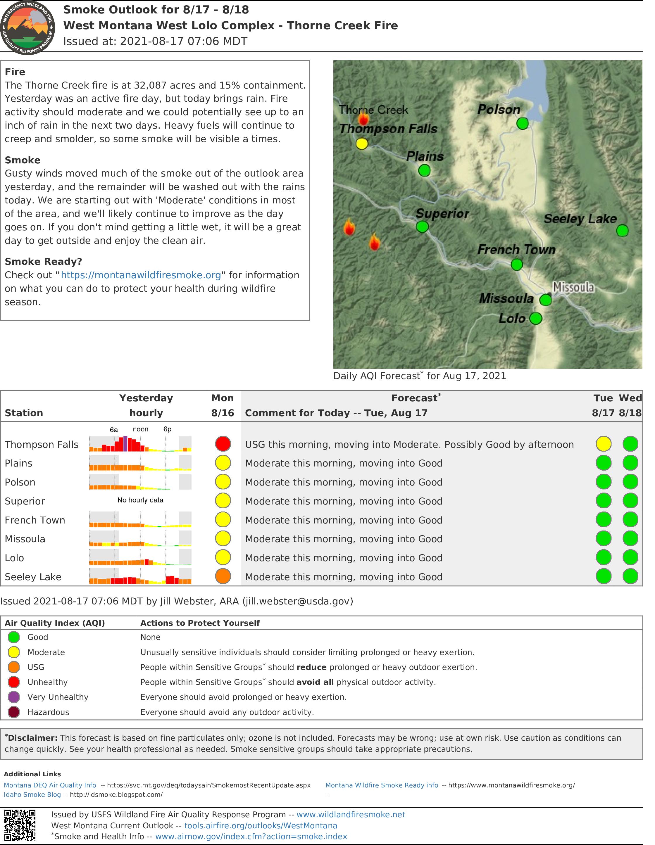
8172021 Daily Update for West Lolo Complex Thorne Creek Fire
Related Incident:
Publication Type: News
Thorne Creek Fire Statistics
- Location: 5 miles NE of Thompson Falls
- Date of Origin: 7/7/2021
- Cause: Lightning
- Acres: 35,993
- Containment: 15%
- Injuries: 5
Resources
- Crews: 6
- Dozers: 1
- Engines: 13
- Skidgens: 2
- Helicopters: 5
- Water Tenders: 12
- Masticator: 1
- Personnel: 374
Summary: As predicted, the West Lolo Complex (Thorne Creek Fire) grew significantly yesterday under a Red Flag Warning. Aerial and ground resources successfully protected structures, reinforced control lines and held the fire at Thompson River Road. A cooling trend began to moderate fire behavior overnight and is expected to persist through the remainder of the week.
Yesterday, the Sanders County Sheriff cancelled the pre-evacuation warning for the Graves NE, Graves SE and Harlow Zones and lowered the Ashley Zone evacuation level to pre-evacuation. The Thompson River Zone remains under an evacuation order.
The U.S. Forest Service has closed the Deer Horn and Beatrice Road systems, and the West Fork of Fishtrap Road (including the campground) due to increased fire activity. The ACM Road closure remains in effect.
The rescheduled public meeting will take place tomorrow night at 5:30 p.m. at Ainsworth Park in Thompson Falls. This meeting will be recorded and posted on YouTube and Facebook.
Yesterday: Air attack coordinated five helicopters which dropped water to protect structures and reinforce control lines. In Division Charlie, fire burned into the Goat Creek and Graves Creek/Four Lakes Creek drainages. In Division Echo, as the fire advanced toward the 2014 Spruce 2 fire footprint, resources scouted out the area near the Division Echo/Division Juliet division break to support the development of a long-term strategy to connect the fire to the Copper King Fire footprint. In Division Juliet, fire spread towards the Priscilla Peak Lookout while resources scouted out potential contingency lines. In Division November, helicopters, engines and volunteer fire department resources successfully protected structures and held the fire at Thompson River Road. Division Zulu conducted burnout operations and mopped up. A hotshot crew and other resources continued those operations overnight.
Today: Operations added a new Division Papa from the previous Division November break to Thompson River Road. This strategic decision will allow Division November to focus on safely planned, low intensity firing operations in the Thompson River Road Corridor and around the Copper King Fire footprint to keep up with the fire’s natural progression. Division Charlie will continue to monitor the fire’s spread to the northeast, as well as mop up along the eastern perimeter with Divisions Zulu and Papa. Divisions Echo and Juliet will scout out areas further to the north and northeast of the fire’s perimeter in preparation for the fire’s continued spread.
At 9 a.m., a single engine air tanker (SEAT) dropped retardant on Priscilla Peak to protect the lookout and a radio tower in that area.
Public Meeting: The Gold Team will host a public meeting tomorrow at 5:30 p.m. at Ainsworth Park in Thompson Falls. This meeting will be recorded and posted on YouTube and Facebook.
Evacuations: 53 residents remain under evacuation orders.
Evacuation Order: All residences in the Thompson River Zone.
Pre-Evacuation/Warning: All residences in the Ashley Zone.
No Evacuation Orders: All residences in the Graves Northeast, Graves Southeast and the Harlow Zones.
Color-coded evacuation maps are available on InciWeb and Facebook. The Gold Team is coordinating closely with local law enforcement and emergency management officials to return residents safely to their homes as soon as possible. The Red Cross Shelter is available in Thompson Falls. If you need assistance, please call 800-272-6668.
Weather: Today will be cooler and rainy with a slight chance of thunderstorms. Erratic winds will replace blustery morning winds at midday. There is a 90% chance of wetting rain today and a 70% chance on Wednesday. Cool, moist conditions are forecast for the rest of the week.
Closures and Additional Information:
- NEW: The U.S. Forest Service has closed the Deer Horn and Beatrice Road system, and the West Fork of Fishtrap Road (including the campground) due to increased fire activity.
- NEW: Air Operations is expanding the current temporary flight restriction today. New details will be available in tomorrow’s update. Please visit tfr.faa.gov for more information.
- The U.S. Forest Service ACM Road closure remains in effect.
- The Thorne Creek Fire is a No Drone Zone! If you fly, we can’t! Visit www.knowbeforeyoufly.org.
- Air quality and smoke monitoring information is available at https://sites.google.com/firenet.gov/wfaqrp-airfare-tools.
- Information Boards are in Thompson Falls at Ainsworth Park, Harvest Foods and Wild Goose Landing and in Plains at the U.S. Forest Service Ranger District. Local businesses also are posting maps and updates and sharing information cards.
- KNOW BEFORE YOU GO! Forest closure information is available on InciWeb under the “Maps” and “Closures” tabs.
- STAGE 2 fire restrictions are in effect. Visit mtfireinfo.org to learn more.
- Ready, Set, GO! Wildland fire preparedness for ranchers and farmers can be found at www.dnrc.mt.gov.
Residents can reduce wildfire risk by following Firewise building construction and vegetation management principles. Visit www.firewise.org for more information.
8182021 Daily Update for West Lolo Complex Thorne Creek Fire
Related Incident:
Publication Type: News
Thorne Creek Fire Statistics
- Location: 5 miles NE of Thompson Falls
- Date of Origin: 7/7/2021
- Cause: Lightning
- Acres: 38,688
- Containment: 15%
- Injuries: 5
Resources
- Crews: 7
- Dozers: 1
- Engines: 17
- Skidgens: 2
- Helicopters: 5
- Water Tenders: 14
- Masticator: 1
- Personnel: 428
Summary: After two days of Red Flag Warnings, a cold front yesterday brought rain to the West Lolo Complex (Thorne Creek Fire) with 1.5 inches of rain on the north side of the fire and closer to 0.6 to 0.75 inches on the east.
The rescheduled public meeting is tonight at 5:30 p.m. at Ainsworth Park in Thompson Falls. This meeting will be recorded and posted on YouTube and Facebook.
Yesterday: Much-needed rain provided a respite for firefighters. Divisions Charlie, Zulu and Papa looked for hot spots and continued mopping up. In Division November, firefighters continued to work around homes and structures along the Thompson River Road where the fire has grown west and north of the Copper King Fire footprint. No homes or other buildings have been lost. Division Echo identified ways to strategically and safely bring low-intensity fire down from the Deep Creek footprint to the West Fork and Fish Trap Creek. However, all homes and other structures remain secure and intact. Weather and smoke prevented aerial resources from putting retardant around Priscilla Peak Tower. Instead, firefighters wrapped the tower in a fire-resistant material. Hotshot crews and other resources continued mop up overnight.
Today: Divisions Charlie, Zulu and Papa will capitalize on yesterday’s moisture to mop up, hold and patrol. Division November will remove brush around homes and other buildings in the Thompson River Road Corridor. Firefighters in that division may also start scouting in the Fish trap area. Structure Protection will start pulling sprinklers, pumps and other equipment from structures in the Thompson River Road. Once that work is complete, firefighters may begin future scouting in the Fish Trap area. A new Division Hotel has been added in anticipation of future needs and fire spread northeast of the fire’s current perimeter. Both Divisions Hotel and Juliet will investigate future control and containment lines, including natural features that could slow the fire’s spread north of the Liver Ridge Road system. Division Echo will start putting in saw line and possibly dozer line in the Benson Draw area. The night shift will transition into a swing shift. A helicopter will assess the lookout tower and repeater on Priscilla Peak.
Public Meeting: This meeting is tonight at 5:30 p.m. at Ainsworth Park in Thompson Falls and will be recorded and posted on YouTube and Facebook.
Evacuations: 53 residents remain under evacuation orders.
- Evacuation Order: All residences in the Thompson River Zone.
- Pre-Evacuation/Warning: All residences in the Ashley Zone.
Color-coded evacuation maps are available on InciWeb and Facebook. The Gold Team is coordinating closely with local law enforcement and emergency management officials to return residents safely to their homes as soon as possible. The Red Cross Shelter is available in Thompson Falls. If you need assistance, please call 800-272-6668.
Weather: Cool, wet weather will continue today and into the weekend. High temperatures will reach the upper 60s to low 70s this afternoon.
Closures and Additional Information:
- The U.S. Forest Service has closed the Deer Horn and Beatrice Road system, and the West Fork of Fishtrap Road (including the campground) due to increased fire activity.
- Air Operations plans to take one more reconnaissance flight today before finalizing the expansion of the temporary flight restriction (TFR) is located at tfr.faa.gov.
- The U.S. Forest Service ACM Road closure remains in effect.
- The Thorne Creek Fire is a No Drone Zone! If you fly, we can’t! Visit www.knowbeforeyoufly.org.
- Air quality and smoke monitoring information is available at https://sites.google.com/firenet.gov/wfaqrp-airfare-tools.
- Information Boards are in Thompson Falls at Ainsworth Park, Harvest Foods and Wild Goose Landing and in Plains at the U.S. Forest Service Ranger District. Local businesses also are posting maps and updates and sharing information cards.
- KNOW BEFORE YOU GO! Forest closure information is available on InciWeb under the “Maps” and “Closures” tabs.
- STAGE 2 fire restrictions are in effect. Visit mtfireinfo.org to learn more.
- Ready, Set, GO! Wildland fire preparedness for ranchers and farmers can be found at www.dnrc.mt.gov.
Residents can reduce wildfire risk by following Firewise building construction and vegetation management principles. Visit www.firewise.org for more information.
Public meeting today at 530 pm at Ainsworth Park in Thompson Falls
Related Incident:
Publication Type: Announcement
Latest evacuation information
Related Incident:
Publication Type: Announcement
Evacuations: 53 residents remain under evacuation orders.
8192021 Daily Update for West Lolo Complex Thorne Creek Fire
Related Incident:
Publication Type: News
Thorne Creek Fire Statistics
- Location: 5 miles NE of Thompson Falls
- Date of Origin: 7/7/2021
- Cause: Lightning
- Acres: 38,688
- Containment: 15%
- Injuries: 5
Resources
- Crews: 2
- Dozers: 1
- Engines: 16
- Skidgens: 2
- Helicopters: 5
- Water Tenders: 14
- Masticator: 0
- Personnel: 321
Summary: The West Lolo Complex (Thorne Creek Fire) had minimal fire activity yesterday. Heat throughout the fire area continues to produce smoke as it consumes heavy fuels; however, wet fuels led to little fire spread. The sun may dry out some fuels today, but fire behavior is expected to be quiet again.
The Forest Service plans to open the ACM Road today. Thompson River Road, the Deer Horn and Beatrice Road systems, and West Fork of Fishtrap Creek Road (including the campground) remain closed.
Yesterday: Firefighters capitalized on moisture, making progress on mop up and adding containment lines which now extend from Copper King all the way to and behind the church (the increased containment percentage will be reflected in tomorrow’s update). Division Echo/Juliet used saws to remove debris and snags and put in dozer line tying into the West Fork. Division Hotel assessed values at risk on private and state property. Structure Protection continued along Thompson River Road and in the Copper King community. Division November mopped up from Copper King down to the church and began pulling out some equipment. Some heavy fuels are smoking in that division which firefighters are addressing one by one.
A recording of the public meeting in Thompson Falls is posted on YouTube and Facebook.Today: Divisions Charlie/Zulu/Papa and November will continue mop up and patrol along the fireline, as well as remove unneeded equipment. Division November will also mop up around homes in Copper King and Snider communities. Division Echo will finish removing hose and sprinklers west of the 2014 Spruce 2 Fire footprint and continue saw and dozer work along the Forest Road 7685 Road system. Divisions Hotel and Juliet will evaluate the potential for putting handline around the fire that slopped over the mechanical line near Barktable Road. Structure Protection will assess needs in the Fishtrap and Big Prairie communities. Aerial resources remain available to engage the fire as needed.
Evacuations: 30 residents remain under evacuation orders.
- Evacuation Order: All residences in the Thompson River Zone.
- Pre-Evacuation/Warning: All residences in the Ashley Zone.
Color-coded evacuation maps are available on InciWeb and Facebook. The Gold Team is coordinating closely with local law enforcement and emergency management officials to return residents safely to their homes as soon as possible. The Red Cross Shelter is available in Thompson Falls. If you need assistance, please call 800-272-6668.
Weather: Expect cool and cloudy conditions with a slow rebound to warmer temperatures and some drying out as wind increases. There is a chance for showers late tonight and a chance for thunderstorms Friday afternoon. The next chance for a wetting rain is late Friday and early Saturday. A drier period begins next week with temperatures pushing into the 80s.
Closures and Additional Information:
- NEW: The Forest Service plans to open the ACM Road today.
- Thompson River Road, the Deer Horn and Beatrice Road system, and the West Fork of Fishtrap Creek Road (including the campground) remain closed.
- The temporary flight restriction (TFR) will be updated later today and available at tfr.faa.gov.
- The Thorne Creek Fire is a No Drone Zone! If you fly, we can’t! Visit www.knowbeforeyoufly.org.
- Air quality and smoke monitoring information is available at https://sites.google.com/firenet.gov/wfaqrp-airfare-tools.
- Information Boards are in Thompson Falls at Ainsworth Park, Harvest Foods and Wild Goose Landing and in Plains at the U.S. Forest Service Ranger District. Local businesses also are posting maps and updates and sharing information cards.
- KNOW BEFORE YOU GO! Forest closure information is available on InciWeb under the “Maps” and “Closures” tabs.
- STAGE 2 fire restrictions are in effect. Visit mtfireinfo.org to learn more.
- Ready, Set, GO! Wildland fire preparedness for ranchers and farmers can be found at www.dnrc.mt.gov.
Residents can reduce wildfire risk by following Firewise building construction and vegetation management principles. Visit www.firewise.org for more information.
Ashley removed from preevac status and ACM Road open
Related Incident:
Publication Type: Announcement
The Ashley area has been removed from the Pre-Evacuation status. There will be no restrictions on this area and residents may come and go as normal. The ACM road is now open for travel. The Snider and Copper King communities are still in the Evacuation Status.
Thank you,
Tom Rummel
Sanders County Sheriff