
Incident Publication
Goose Fire Area Closure Order 07AUG21
Related Incident:
Publication Type: Closures
Goose Fire Area Closure 07AUG21, enacted 07AUG21
Burnt Peak Fire 71621 Update
Related Incident:
Publication Type: News
Burnt Peak Fire Update
Friday, July 16, 2021
Contact Fire Information: 2021.BurntPeak@firenet.gov
(a new phone number will be available tomorrow)
InciWeb: https://inciweb.nwcg.gov/incident/7619/
Facebook: https://www.facebook.com/kootenainf
This morning, Tim Roide’s Great Basin Type 2 Incident Management Team #4 assumed command of the Burnt Peak Fire. To support the assigned firefighters, a camp has been established adjacent to Highway 56, south of the intersection with Highway 2. Please be cautious traveling through the area as heavy equipment will be leaving and entering the highway. Traffic will be particularly heavy in the mornings and evenings.
Priorities for the Burnt Peak Fire include preventing damage to private structures, infrastructure, and timber values in North Fork Keeler Creek and along the Highway 56 corridor; implementing fire suppression tactics that minimize fire spread and reduce potential for the fire to align with drainages and terrain that may increase fire growth; and developing long term plans to provide management actions for the duration of the fire. To inform planning, firefighters will be evaluating structures and values to determine the necessary actions and resources needed to protect them as the fire continues to grow.
There is one helicopter assigned directly to the Burnt Peak Fire, and additional helicopters, as well as airtankers, are available to support this and other area fires, including the Ruby Fire. Additional resources have been ordered, including crews and helicopters. Overall firefighting resource availability is limited due to the high fire activity throughout the region and the nation.
Evacuations – There are no evacuations at this point; however, some residences have been placed in the Set category, on pre-evacuation notice. All residents in the area should be Ready to evacuate should this fire or another make evacuations necessary. Visit the Ready, Set, Go website for information on being wildfire ready, https://www.wildlandfirersg.org/s/?language=en_US.
Closures – For the safety of firefighters and the public, the Kootenai National Forest has enacted a closure order, which includes the following forest roads: North Fork Keeler Creek (404), Keeler/Rattle Creek (473), and Lime Butte (4735). Please reference maps for exact boundaries and respect any roadblocks you encounter. The current closure order and map can be found at https://inciweb.nwcg.gov/incident/closures/7619/.
Fire Restrictions – Stage 2 fire restrictions are in place for Lincoln County and will be enacted by the Kootenai National Forest tomorrow. View the complete list of fire restrictions at https://www.fs.usda.gov/kootenai/.
Fire danger is extreme, and the vegetation is much drier than normal due to the record heat and lack of rain. Please respect fire restrictions and recreate responsibly.
Burnt Peak Fire 71721 Update
Related Incident:
Publication Type: News
Burnt Peak Fire Update
Saturday, July 17, 2021
Fire behavior moderated yesterday on the Burnt Peak Fire due to slightly cooler temperatures and minimal winds, allowing firefighters to make progress on fireline directly adjacent to the fire and on contingency lines further away. The Burnt Peak Fire mainly spread laterally, across the slope, and downhill. Some tree torching occurred, which produces embers that ignite spot fires around the main fire. These create challenges for firefighters as they may initially go undetected until conditions grow warmer and winds increase again.
Firefighters will take advantage of existing roads or natural barriers to limit fire spread and provide the best chances for success in containing the fire. Equipment and masticators are working along roads to reduce fuels and improve their ability to serve as fireline. Removing branches and surface fuels stops fire from spreading upwards into the crowns of the trees and makes it easier for firefighters to suppress the fire.
Structure protection specialists will be visiting area properties to complete assessments that inform as fire managers developing plans for the long-term management of the Burnt Peak Fire. Many resources, especially helicopters and airtankers, are being shared between the Burnt Peak Fire and other area fires.
Traffic speeds have been reduced on Highway 56 near the fire camp. Please use lights when traveling through the area and be aware of increased traffic, especially in the mornings and evenings when firefighting resources will be most prevalent.
Evacuations – There are no evacuations at this point; however, some residences have been placed in the Set category, on pre-evacuation notice. All residents should be Ready to evacuate should evacuations be necessary. Visit the Ready, Set, Go website for information on being wildfire ready, https://www.wildlandfirersg.org. And sign up for Code Red alerts on the Lincoln County webpage, http://lincolncountymt.us/.
Closures – For the safety of firefighters and the public, the Kootenai National Forest has enacted a closure order, which includes the following forest roads: North Fork Keeler Creek (404), Keeler/Rattle Creek (473), and Lime Butte (4735). Please reference maps for exact boundaries and respect any roadblocks you encounter. The current closure order and map can be found at https://inciweb.nwcg.gov/incident/closures/7619/.
Fire Restrictions – Stage 2 fire restrictions are in place for Lincoln County and the Kootenai National Forest. View the complete list of fire restrictions at https://www.fs.usda.gov/kootenai/.
Fire danger is extreme, and the vegetation is much drier than normal due to the record heat and lack of rain. Please respect fire restrictions and recreate responsibly.
Burnt Peak 71821 Update
Related Incident:
Publication Type: News
Burnt Peak Fire Update 7/18/2021
The Burnt Peak Fire is expected to continue flanking on the east and west sides while slowly backing down the slope on the north and south sides. This behavior has slowed fire growth and given managers time to assess the fire and evaluate opportunities to limit fire spread. Firefighters are working with masticators and other heavy equipment to prep along roadways, decreasing brush and tree limbs and improving the ability to use these roads as contingency firelines. The fire is backing on the south side to the Keeler/Rattle Creek Road where the improved roadway is already serving as fireline, providing the current containment. The north side of the fire is especially challenging with extreme terrain and difficult conditions. Fire managers are developing plans to safely and effectively engage in fire suppression actions in this area.
Fire specialists are assessing structures and developing plans to defend values at risk and limit loss or damage as the fire grows. These long-term structure defense plans will continue to be of value throughout this extended fire season. Many resources are being shared between the Burnt Peak Fire and other area fires.
Abnormally hot and dry weather will continue through Monday with sunny, smoky skies and temperatures into the 90s for lower elevations and mid-80s on the ridgelines. Forecasters predict monsoonal moisture will move into the region after Monday bringing cooler air and slightly higher overnight humidity. Increasing afternoon winds may cause spotting as embers ignite vegetation ahead of the main fire front.
Evacuations – While there are no current evacuations, some residences are on pre-evacuation notice. Visit the Montana DNRC Prevention and Preparedness website for information on being wildfire ready, http://dnrc.mt.gov/divisions/forestry/fire-and-aviation/fire-prevention-and-preparedness.
Sign up for Code Red alerts on the Lincoln County webpage, http://lincolncountymt.us/.
Closures – For the safety of firefighters and the public, the Kootenai National Forest enacted an area closure that includes: North Fork Keeler Creek (404), Keeler/Rattle Creek (473), and Lime Butte (4735) roads. Please reference maps for exact boundaries and respect any roadblocks you encounter. The current closure order and map can be found at https://inciweb.nwcg.gov/incident/closures/7619/.
Fire Restrictions – Stage 2 fire restrictions are in place for Lincoln County and the Kootenai National Forest. View the complete list of fire restrictions at https://www.fs.usda.gov/kootenai/.
Fire danger is extreme, and the vegetation is much drier than normal due to the record heat and lack of rain. Please respect fire restrictions and recreate responsibly.Burnt Peak Fire 71921 Update
Related Incident:
Publication Type: News
Burnt Peak Fire Update
Monday, July 19, 2021
On the southeast corner of the fire and along a portion of the Keeler/Rattle Creek Road, firefighters have contained 13% of the Burnt Peak Fire perimeter. This section will be continuously monitored as firefighters progress along the road to the west and from the road uphill to the north. Firefighting resources are still being shared between multiple local fires, as numerous large fires across the west are competing for personnel, equipment, and support.
The inversion yesterday morning limited fire activity. Once it dissipated, fire activity increased on the western edge of the fire. Today, monsoonal moisture is expected to enter the region. While this will bring slightly lower temperatures and higher relative humidity, there is also a possibility of dry scattered thunderstorms.
For the past few days, the fire spread has mainly occurred across the slope with small uphill runs. Gusty outflow winds from passing storms may lead to erratic fire behavior. Firefighters will be attentive to changing conditions and to any new fires that may ignite. Extreme fire danger and critically dry vegetation, combined with gusty winds, could lead to rapid fire growth on the Burnt Peak Fire or other new or existing wildfires.
Evacuations – While there are no current evacuations, some residences have been placed in the Set category, on pre-evacuation notice. All residents should be Ready to evacuate should evacuations be necessary. Visit the Montana DNRC Prevention and Preparedness website for resources and information on being wildfire ready, http://dnrc.mt.gov/divisions/forestry/fire-and-aviation/fire-prevention-and-preparedness. And sign up for Code Red alerts on the Lincoln County webpage, http://lincolncountymt.us/.
Closures – For the safety of firefighters and the public, the Kootenai National Forest enacted an area closure that includes: North Fork Keeler Creek (404), Keeler/Rattle Creek (473), and Lime Butte (4735) roads. Please reference maps for exact boundaries and respect any roadblocks you encounter. The current closure order and map can be found at https://inciweb.nwcg.gov/incident/closures/7619/.
Fire Restrictions – Stage 2 fire restrictions are in place for Lincoln County and the Kootenai National Forest. View the complete list of fire restrictions at https://www.fs.usda.gov/kootenai/.Burnt Peak and South Yaak Fires 72021 Update
Related Incident:
Publication Type: News
Burnt Peak Fire
Cloud cover throughout the day yesterday moderated temperatures, humidity, and fire behavior on the Burnt Peak Fire. Firefighters used the advantageous conditions to construct fireline and improve contingency firelines ahead of the gusty winds predicted again today. The chance for lightning has diminished, and there is no indication of measurable moisture in the forecast. Favorable conditions will give way to warmer and drier conditions by the weekend. The potential for large fire growth remains, as vegetation is at critically low moisture levels. Additional firefighting resources may arrive in the next few days as some regional fires are contained or crews return from days off and become available for their next assignment.
Evacuations – While there are no current evacuations, some residences have been placed in the Set category, on pre-evacuation notice. All residents should be Ready to evacuate should evacuations be necessary. Visit the Montana DNRC Prevention and Preparedness website for resources and information on being wildfire ready, http://dnrc.mt.gov/divisions/forestry/fire-and-aviation/fire-prevention-and-preparedness. And sign up for Code Red alerts on the Lincoln County webpage, http://lincolncountymt.us/.
Closures – For the safety of firefighters and the public, the Kootenai National Forest enacted an area closure that includes: North Fork Keeler Creek (404), Keeler/Rattle Creek (473), and Lime Butte (4735) roads. Please reference maps for exact boundaries and respect any roadblocks you encounter. The current closure order and map can be found at https://inciweb.nwcg.gov/incident/closures/7619/.
South Yaak Fire
Great Basin Team 4 assumed command of the South Yaak Fire this morning. Resources will continue to be shared between the two fires and supported from the fire camp located on Highway 56, south of the intersection with Highway 2. There are no evacuations or closures currently associated with the fire. Fire suppression is challenging due to the very steep terrain and limited crew availability. The fire produces large amounts of smoke as it smolders in thick duff and heavy logging slash.
Fire Restrictions – Stage 2 fire restrictions are in place for Lincoln County and the Kootenai National Forest. View the complete list of fire restrictions at https://www.fs.usda.gov/kootenai/.
Smoke – Heavy regional smoke is pervasive. Limit heavy exertion outdoors, and those with sensitivities should limit time outdoors. Visit the Montana DEQ site, https://deq.mt.gov/Air/FireUpdates/RelevantLinks, or https://svc.mt.gov/deq/todaysair/, for information and air quality updates.
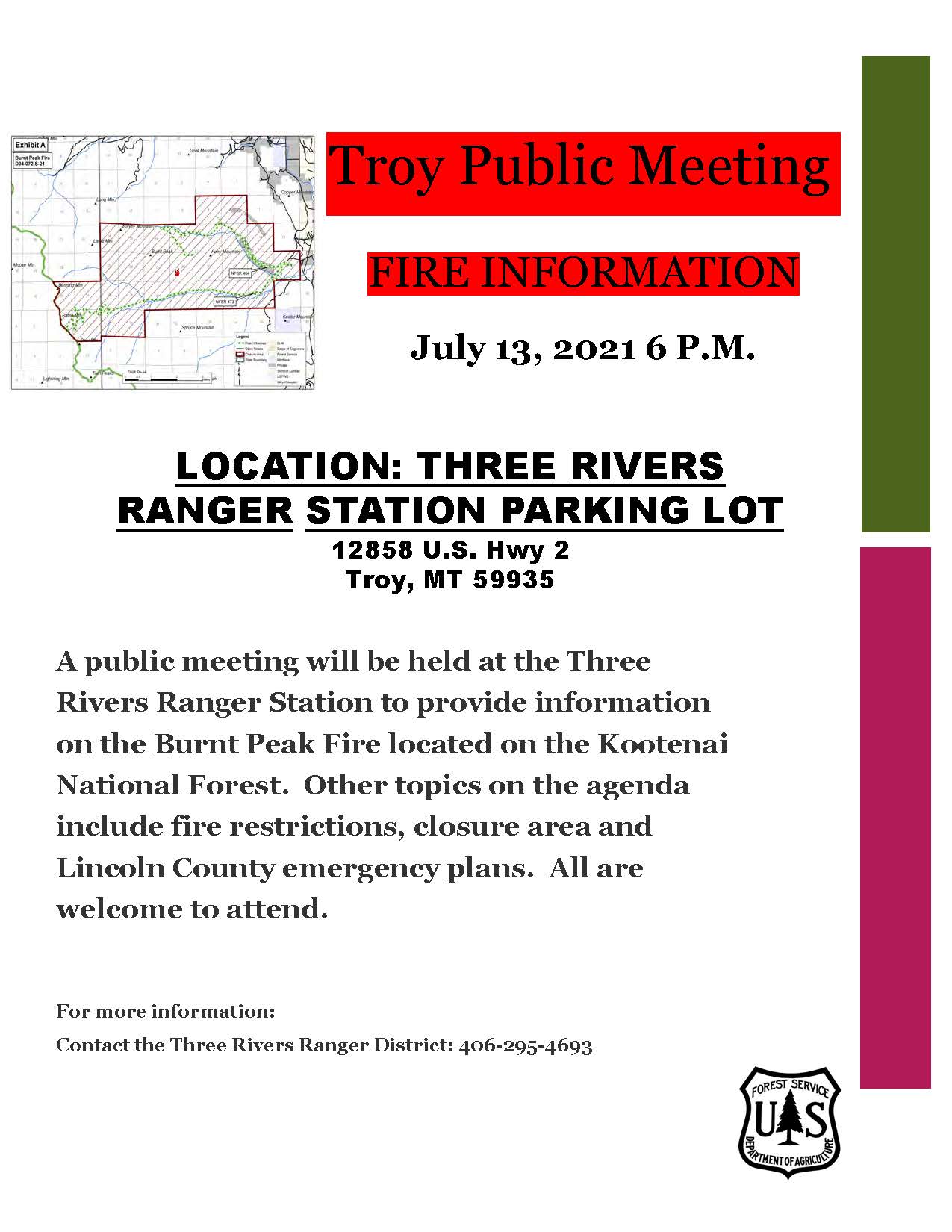
Burnt Peak and South Yaak Fires Public Meeting
Related Incident:
Publication Type: Announcement
Three Rivers Ranger District
Kootenai National Forest
Community Meeting
Burnt Peak Fire & South Yaak Fire
Wednesday, July 21
6 PM
Troy Ranger Station
12858 Hwy 2; Troy, Montana
![]()
The meeting will also be broadcast via the Kootenai National Forest Facebook page.
Burnt Peak and South Yaak Fires 72121 Update
Related Incident:
Publication Type: News
Contact Fire Information: 208.296.9706 or 2021.BurntPeak@firenet.gov
Facebook: https://www.facebook.com/kootenainf
Burnt Peak Fire
InciWeb: https://inciweb.nwcg.gov/incident/7619/
Cloud cover yesterday morning moderated temperatures, raised humidity, and produced a few passing showers that helped reduce fire behavior on the Burnt Peak Fire. Firefighters used the advantageous conditions to construct fireline and improve contingency firelines. An additional disturbance will pass over the fire today bringing light showers and a chance of isolated thunderstorms. The potential for large fire growth remains, as vegetation is still at critically low moisture levels. Firefighters will continue to employ both direct tactics, working along the edge of the fire where it is safe to do so, and indirect tactics, including removing brush from roads in front of the fire so those improved roadways may be used as fireline. This indirect approach is a way for firefighters to be safe and successful using existing natural and manmade features in difficult terrain.
Evacuations – While there are no current evacuations, some residences have been placed in the Set category, on pre-evacuation notice. All residents should be Ready to evacuate should evacuations be necessary. Visit the Montana DNRC Prevention and Preparedness website for resources and information on being wildfire ready, http://dnrc.mt.gov/divisions/forestry/fire-and-aviation/fire-prevention-and-preparedness. And sign up for Code Red alerts on the Lincoln County webpage, http://lincolncountymt.us/.
Closures – For the safety of firefighters and the public, the Kootenai National Forest enacted an area closure that includes: North Fork Keeler Creek (404), Keeler/Rattle Creek (473), and Lime Butte (4735) roads. Please reference maps for exact boundaries and respect any roadblocks you encounter. The current closure order and map can be found at https://inciweb.nwcg.gov/incident/closures/7619/.
South Yaak Fire
InciWeb: https://inciweb.nwcg.gov/incident/7696/
Resources will continue to be shared between the two fires and supported from the fire camp located on Highway 56. Firefighters have been successful getting hoses and water along the eastern edge and are working on indirect containment lines where the terrain is especially steep. Evaluations for structure protection needs are taking place on Killbrennan Lake and Eastside Roads. There are no current evacuations or closures for the fire. Smoldering duff is producing heavy smoke that settles in low areas overnight.
Fire Restrictions – Stage 2 fire restrictions are in place for Lincoln County and the Kootenai National Forest. View the complete list of fire restrictions at https://www.fs.usda.gov/kootenai/.
Smoke – Heavy regional smoke is pervasive. Limit heavy exertion outdoors, and those with sensitivities should limit time outdoors. Visit the Montana DEQ site, https://deq.mt.gov/Air/FireUpdates/RelevantLinks, or https://svc.mt.gov/deq/todaysair/, for information and air quality updates.
Burnt Peak and South Yaak Fires 72221 Update
Related Incident:
Publication Type: News
Burnt Peak Fire
The Burnt Peak Fire continues to move cross slope and to back downslope. Yesterday’s brief rain, cooler temperatures, and higher humidity aided firefighters in increasing containment, but the respite is not enough to overcome the existing critical conditions. Today will again be cooler, but gusty winds are expected as a weak, dry cold front passes through. Tomorrow, the next warming and drying trend will return.
Firefighters will continue work directly along the eastern edge of the fire perimeter. Structure protection plans, contingency firelines, and strategic plans are ongoing to assist the local fire managers and cooperators in the ongoing management of the fire until significant moisture arrives to the area.
Evacuations – While there are no current evacuations, some residences have been placed in the Set category, on pre-evacuation notice. All residents should be Ready to evacuate should evacuations be necessary. Visit the Montana DNRC Prevention and Preparedness website for resources and information on being wildfire ready, http://dnrc.mt.gov/divisions/forestry/fire-and-aviation/fire-prevention-and-preparedness. And sign up for Code Red alerts on the Lincoln County webpage, http://lincolncountymt.us/.
Closures – For the safety of firefighters and the public, the Kootenai National Forest enacted an area closure that includes: North Fork Keeler Creek (404), Keeler/Rattle Creek (473), and Lime Butte (4735) roads. Please reference maps for exact boundaries and respect any roadblocks you encounter. The current closure order and map can be found at https://inciweb.nwcg.gov/incident/closures/7619/.
South Yaak Fire
The steep terrain on Yaak Mountain is challenging firefighters on the South Yaak Fire. Burning embers and vegetation roll downhill then ignite into flames which run quickly uphill. Fire managers are confident there is little risk of continued spread on the eastern edge of the fire, where firefighters have constructed fireline and used hoses and water to contain the fire perimeter. Firefighters are beginning work now on the western edge, evaluating terrain features such as ridges that are effective places for constructing fireline and limiting fire spread. The South Yaak Fire is also likely to extend for several days, given the challenges of the terrain and limited resources available because of significant fire activity throughout the west.
Fire Restrictions – Stage 2 fire restrictions are in place for Lincoln County and the Kootenai National Forest. View the complete list of fire restrictions at https://www.fs.usda.gov/kootenai/.
Smoke – Visit the Montana DEQ site, https://deq.mt.gov/Air/FireUpdates/RelevantLinks, or https://svc.mt.gov/deq/todaysair/, for information and air quality updates.