
Incident Publication
August 26 Green Ridge and Lick Creek Fire Update
Related Incident:
Publication Type: News
Green Ridge and Lick Creek Fires Update
Northwest Incident Management Team 8, Incident Commander, Kevin Stock
August 26, 2021
Size: 80,421 acres
Containment: 97%
Total Personnel: 7
Location: 20 miles southwest of Asotin, WA
Reported: July 7, 2021
Cause: Lightning
Current Situation: Lick Creek Fire: The Lick Creek Fire remains 80,421 acres and 97% contained. Smoke will continue to be visible as unburned pockets of vegetation inside the fire perimeter are consumed. Crews will continue to mop-up any interior pockets of heat and patrol lines as they can safely do so.
Weather & Smoke Information: Today’s weather will be partly cloudy with smoke and haze. Temperatures will have highs between 61-66 degrees along the ridges and 70-75 degrees in the valley bottoms. Winds will be west to northwest at 6 – 10 mph with gusts to 20 mph. Relative humidity will range from 35-40%. Smoke information is available on Washington Smoke Blog at: https://wasmoke.blogspot.com/
Forest Closures: Closures are in place on the Umatilla National Forest. The forest closure includes all lands on the Pomeroy and Walla Walla Ranger Districts in Washington State. The closure order is available at https://go.usa.gov/xFyhn.
Evacuations: Garfield County currently has Level 1 and Level 2 evacuations in place. Columbia County currently has Level 1 and Level 2 evacuations in place. For more information on evacuations, please visit https://go.usa.gov/xFQJ2 for full information.
Temporary Flight Restrictions: For the safety of the firefighters and aircraft fighting the Green Ridge and Lick Creek Fires, a Temporary Flight Restriction is in place over the fire areas. Please consult the “Notice to Airman” for specifics. Wildfires are a “No Drone Zone.” Whenever a drone is spotted near the fire all aircraft are grounded until we can be sure the drone is clear of the area. For more information, visit http://knowbeforeyoufly.org.
2021.GreenRidge@firenet.gov
Lick Creek Fire Information:
Public Use Restrictions reduced on the Umatilla and WallowaWhitman NFs
Related Incident:
Publication Type: News
NEWS RELEASE
Contacts:
Umatilla National Forest: Darcy Weseman (541-278-3722)
Wallowa-Whitman National Forest: Peter Fargo (541-523-1231)
With the exception of motor vehicles, operating an internal combustion engine, such as a chainsaw, is prohibited without a valid permit. Commercial and personal use firewood permits are regulated by the conditions of the permit and separate from restrictions under this public use restriction.
Regulated closures may be in effect on State and private lands protected by Oregon Department of Forestry (ODF) in northeast and central Oregon. Please check with your local Oregon Department of Forestry office for PURs on lands protected by ODF. For more complete information, contact a local Oregon Department of Forestry office or visit one of the interagency dispatch center’s webpages:
Please remember that it is everyone’s responsibility to know what restrictions are in place when visiting public lands. For more information regarding restrictions on the Umatilla and Wallowa-Whitman National Forests, please contact:
Umatilla National Forest:
Wallowa-Whitman National Forest:
August 27 Green Ridge and Lick Creek Fire Update
Related Incident:
Publication Type: News
Green Ridge and Lick Creek Fires Update
Northwest Incident Management Team 8, Incident Commander, Kevin Stock
August 27, 2021
Umatilla National Forest to further reduce area closure
Related Incident:
Publication Type: Announcement
Umatilla National Forest to further reduce area closure
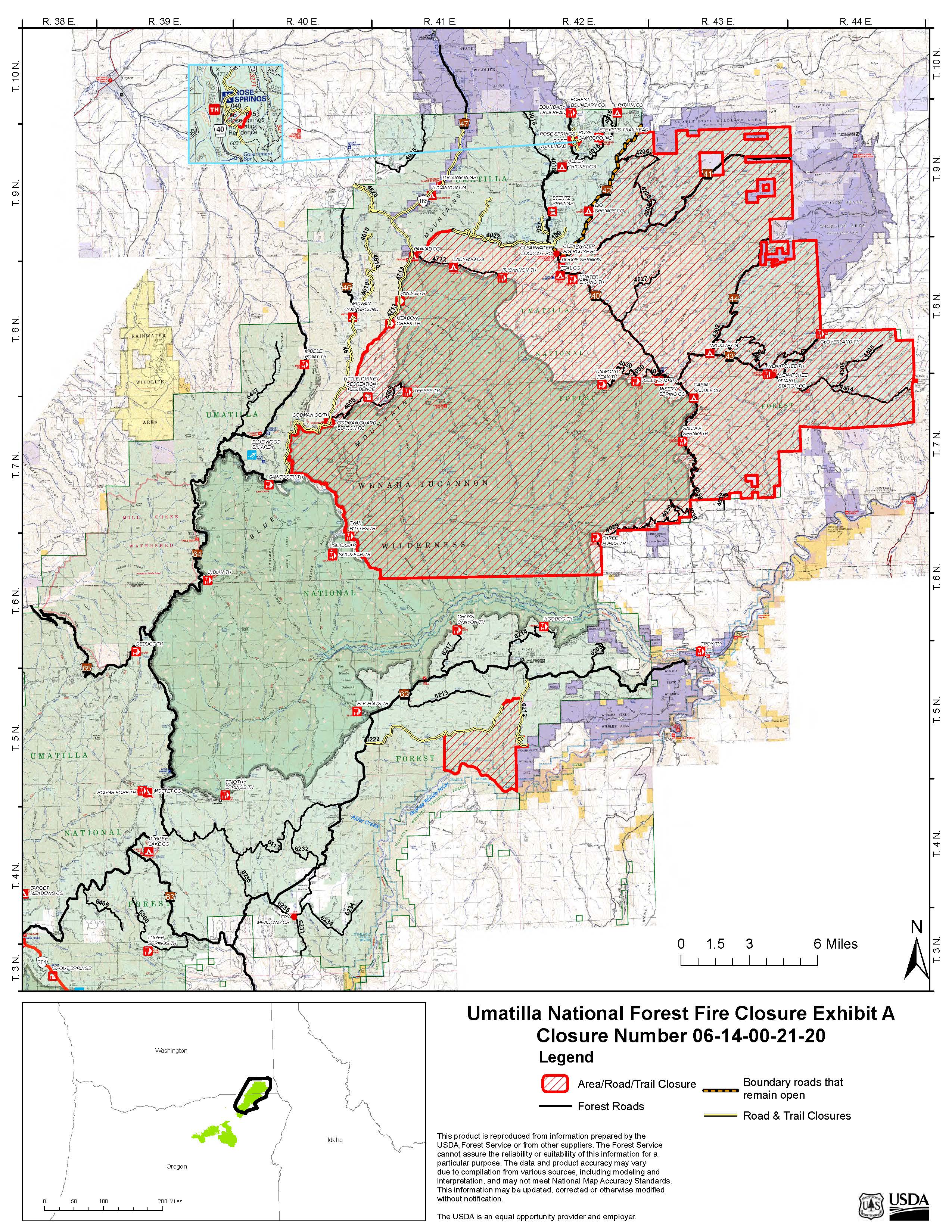
PENDLETON, Ore. (August 27, 2021) — With continued reduced large fire activity across the Forest, Umatilla National Forest officials will further reduce the area closure on Saturday, Aug. 28, reopening access to more lands on the Pomeroy and Walla Walla Ranger Districts.
The modified closure prohibits access to Umatilla National Forest lands surrounding the Lick Creek and Green Ridge fires on the Pomeroy Ranger District and lands surrounding the Elbow Creek Fire on the Walla Walla Ranger District. Public entry is prohibited within the areas identified in the closure, which includes lands, roads, trails and recreational facilities, as described below.
Green Ridge and Lick Creek Fires closure area boundaries include all lands east of: Forest Service Trail (FST) 3103, the western edge of the Wenaha-Tucannon Wilderness boundary near Forest Service Road (FSR) 46 and east of FSR 4713; lands south of FSR 4022 to the junction of FSR 42; lands east of FSR 42 to the Forest boundary; and south to the Oregon/Washington state border. In addition, multiple roads are closed within proximity to ongoing suppression operations, including FSR 46 from Midway Campground (the campground will be open) to Godman Guard Station, FSR 47, FSR 4610, FSR 4712, FSR 4713, FSR 4022, and portions of FSR 4620, FSR 40-150 and FSR 40-080 remain closed. Rose Springs Sno-Park is also closed, which includes a portion of FST 3238.
Elbow Creek Fire closure area boundaries include all National Forest lands east of Bear Creek; south of FSR 6222; west of FSR 6212 and to the Forest boundary on the south. In addition, portions of FSR 6212 and FSR 6222 are also closed.
Visitors planning a trip to areas within the closure should cancel any plans for the next several weeks. These areas remain closed to protect public and firefighter safety as the Forest continues to actively suppress wildfires. Hazards within the closure areas include uncontained fireline and ongoing suppression operations (such as the presence of firefighting resources, large equipment, and aircraft).
A detailed map describing the updated closure area is available at the end of this news release, on the Forest website and at any Forest office. Closure barriers and signs will be posted on the ground.
Electrical generators operated under the following conditions are allowed: § in the center of an area at least 10 feet in diameter that is barren or cleared of all flammable material, or;
§ when fully contained within a pickup truck bed that is empty of all flammable material, or; when factory installed in a recreational vehicle and the generator exhaust discharge is in the center of an area at least 10 feet in diameter that is cleared of all flammable material.
Violating closures and fire restrictions is a violation that carries a mandatory appearance in federal court, punishable as a Class B misdemeanor with a fine of up to $5,000 for an individual or $10,000 for an organization, or up to six months in prison, or both.
Green Ridge Fire: https://inciweb.nwcg.gov/incident/7628
Elbow Creek Fire: https://inciweb.nwcg.gov/incident/7672/
The latest fire information will be posted on the Blue Mountains Fire Information Blog. To receive updates on fires in the Blue Mountains, follow our blog at http://bluemountainfireinfo.blogspot.com/.
Evacuation levels lowered on the Green Ridge and Lick Creek Fires
Related Incident:
Publication Type: Announcement
The evacuation levels have been lowered on the Green Ridge and Lick Creek Fires. The Columbia County Sheriff's Office and the Garfield County Sheriff's Office have lowered all level 2 evacuation notices to a level 1.
August 28 Green Ridge and Lick Creek Fire Update
Related Incident:
Publication Type: News
Green Ridge and Lick Creek Fires Update
Northwest Incident Management Team 8, Incident Commander, Kevin Stock
August 28, 2021
All Level 2 Evacuation areas in Columbia and Garfield Counties have been reduced to Level 1 effective immediately. All of the Level 1 areas remain in place.
The Umatilla National Forest has reduced the size of the Fire Emergency Area Closure. Please see the Green Ridge Facebook page for a full description. With the reduction of the Fire Area Closure, the visiting public is being asked to watch out for fire crews and equipment while traveling on roads. Please drive safely.
A Virtual Facebook Live Public Meeting is Set for Sunday, 7 PM, August 29. The meeting will be carried live on the Green Ridge Fire Facebook page: https://www.facebook.com/greenridgefire2021.
Northwest Incident Management Team 8 assumed management of the Green Ridge and Lick Creek Fires on August 28. The incident command post remains at the Last Resort near Pomeroy, WA.
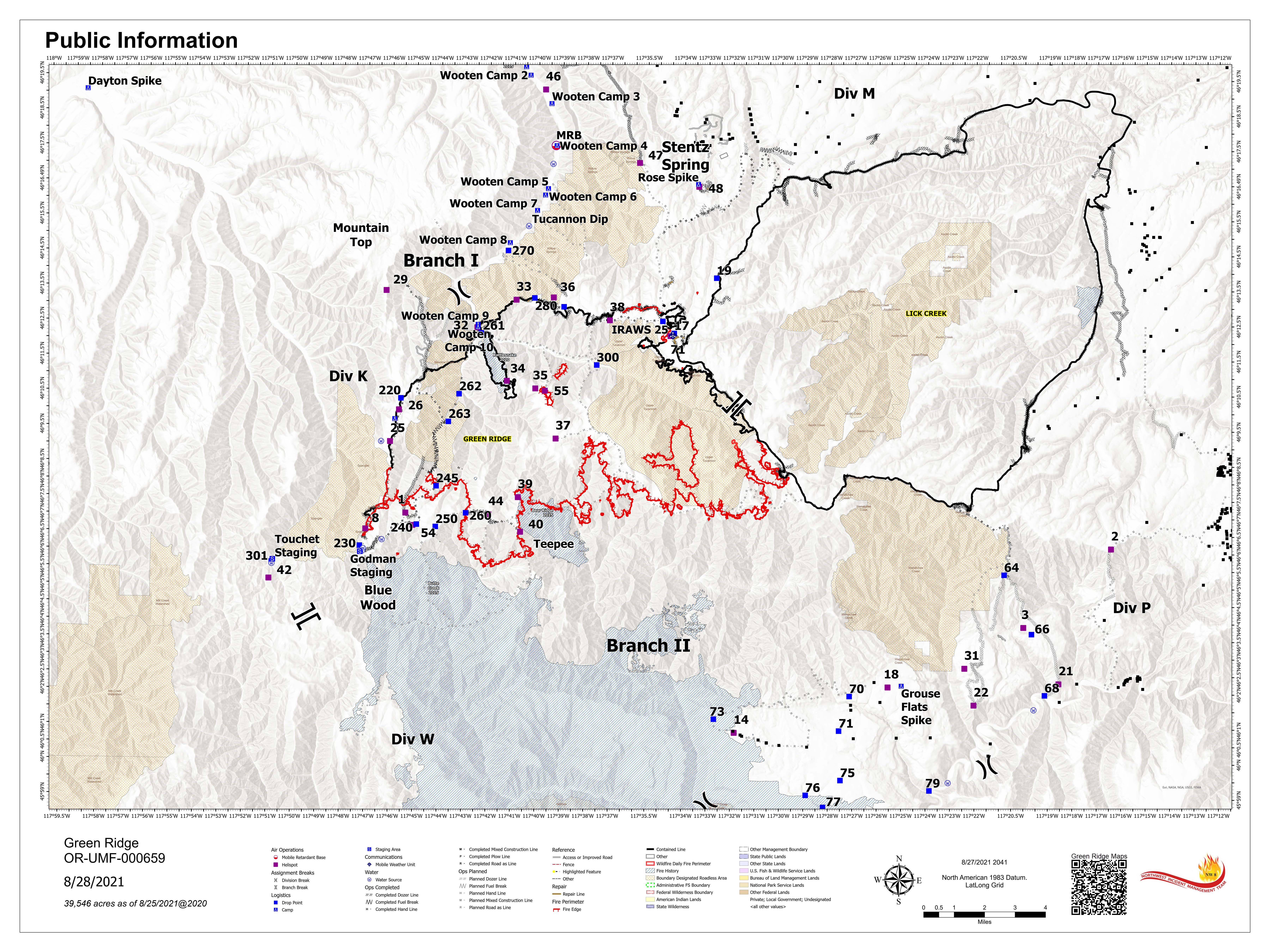
Green Ridge Fire Statistics: Size: 39,598, Containment: 35%, Total Personnel: 216, Location: 30 miles east of Walla Walla, Reported: July 7, 2021, Cause: Lightning.
Lick Creek Fire Statistics: Size: 80,421, Containment: 100%, Total Personnel: 6, Location: 20 miles southwest of Asotin, WA, Reported: July 7, 2021, Cause: Lightning.
Current Situation: Green Ridge Fire: Activity on the Green Ridge Fire was minimal due to periods of rain Thursday night, high relative humidity, and cooler temperatures. A Wilfire Use Module and Umatilla National Forest Type-2 IA crews made good progress yesterday and will keep building direct control line along the southeast corner of the fire from the Jeffery Spring area heading south to Diamond Creek Road in the area around Mount Misery. Winds may be gusty on sections of the fire that today that could test secured line. Crews continued to patrol and mop up other sections of uncontrolled line along portions of the northeast corner, near Clear Water lookout tower and guard station, and southwest corner near Godman Trailhead along Skyline Drive.
Current Situation: Lick Creek Fire: The Lick Creek Fire remains 80,421 acres and is now 100% contained. Smoke will continue to be visible as unburned pockets of vegetation inside the fire perimeter are consumed. Crews will continue to mop-up any interior pockets of heat and patrol lines as they can safely.
Weather & Smoke Information: Today’s weather will be mostly sunny with haze. Temperatures will have highs between 66-71 degrees along the ridges and 75-80 degrees in the valley bottoms. Winds will shift east-northeast to 5 – 8 mph with gusts up to 15 mph in the afternoon. Relative humidity will range from 30-35% above 5000 feet and 25-30% in the valleys. Smoke information is available on Washington Smoke Blog at: https://wasmoke.blogspot.com/
Forest Closures: A reduced Fire Emergency Closure is in place on the Umatilla National Forest and has been updated as of today (August 28, 2021). The closure order map can be found at https://www.fs.usda.gov/Internet/FSE_DOCUMENTS/fseprd948170.pdf
Evacuations: Garfield and Columbia County have dropped all Level 2 areas to Level 1. For more information on evacuations, please visit https://go.usa.gov/xFQJ2 for full information.
Temporary Flight Restrictions: For the safety of the firefighters and aircraft fighting the Green Ridge and Lick Creek Fires, a Temporary Flight Restriction is in place over the fire areas. Please consult the “Notice to Airman” for specifics. Wildfires are a “No Drone Zone.” Whenever a drone is spotted near the fire all aircraft are grounded until we can be sure the drone is clear of the area. For more information, visit http://knowbeforeyoufly.org.
Green Ridge Fire Information:
Information Office: (509) 542-7964
Email: 2021.GreenRidge@firenet.gov
Inciweb: https://inciweb.nwcg.gov/incident/7628/
Facebook: https://www.facebook.com/greenridgefire2021
Lick Creek Fire Information:
Information Office: (509) 780-6238
Email: 2021.LickCreek@firenet.gov
Inciweb: https://inciweb.nwcg.gov/incident/7615/
Facebook: https://www.facebook.com/LickCreekFireGreen Ridge and Lick Creek Fire Facebook Live Meeting August 29th at 730pm
Related Incident:
Publication Type: Announcement
SUNDAY, AUGUST 29
7:00 P.M.

August 30 Green Ridge and Lick Creek Fire Update
Related Incident:
Publication Type: News
Green Ridge and Lick Creek Fires Update
Northwest Incident Management Team 8, Incident Commander, Kevin Stock
August 30, 2021
Please stay clear of firefighting operations and drive safely! With the reduction of the Emergency Fire Area Closure, the public is being asked to watch out for fire crews and equipment while traveling on forest roads. Some roads remain closed with barriers. Barriers are in place to protect firefighters and the public, so please respect the closed areas.
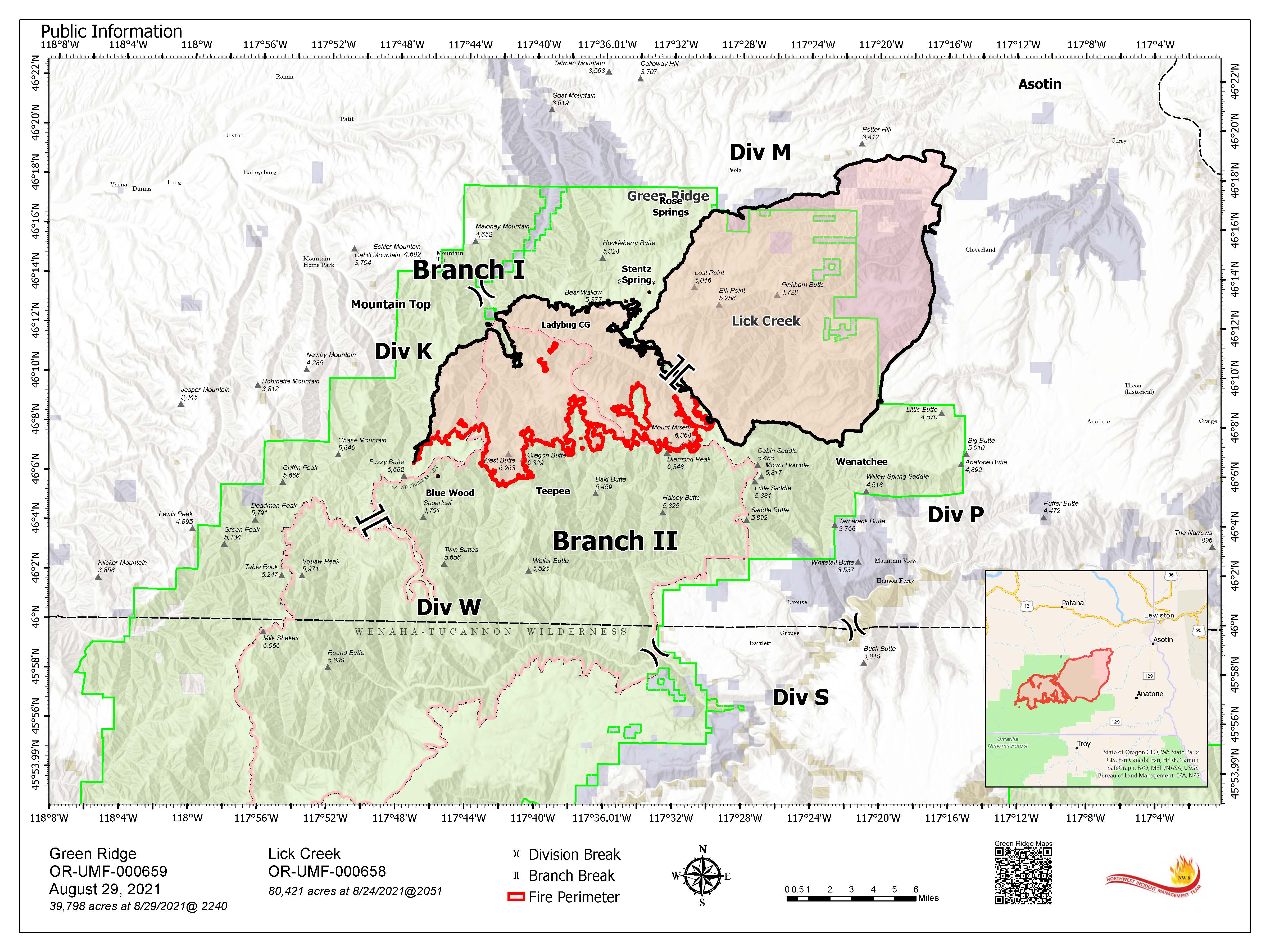
Green Ridge Fire Statistics: Size: 39,798, Containment: 39%, Total Personnel: 185, Location: 30 miles east of Walla Walla, Reported: July 7, 2021, Cause: Lightning.
Lick Creek Fire Statistics: Size: 80,421, Containment: 100%, Total Personnel: 6, Location: 20 miles southwest of Asotin, WA, Reported: July 7, 2021, Cause: Lightning.
Current Situation: Green Ridge Fire: Activity on the Green Ridge Fire yesterday was minimal and this helped firefighters to make good progress. Today, the concern will be increased fire behavior due to predicted wind gusts up to 26 mph coming from the west-southwest. An increase in burning activity and smoke is likely as the winds fan interior islands and pockets of unburned fuels. Firefighters will remain diligent in watching for spots and new smokes to extinguish. The two areas of uncontrolled line in the northeast and southwest corners of the fire have now been contained. Fire crews will continue to patrol and monitor these areas. Further progress was also made on direct containment of the fire in the southeast corner near Diamond Creek Road below Mount Misery. The objective for this area of the fire is to establish containment line going south then west and tie into the Diamond Mountain trailhead. Resource advisors are onsite to provide knowledge of cultural and natural resource areas to be protected. Advisors are also mapping all suppression line constructed for future repair.
Current Situation: Lick Creek Fire: The Lick Creek Fire remains 80,421 acres and is now 100% contained. Smoke will continue to be visible as unburned pockets of vegetation inside the fire perimeter are consumed. Crews will continue to mop-up any interior pockets of heat and patrol lines as they can safely.
Weather & Smoke Information: Mostly sunny today with smoke and haze. Temperatures will remain warm and may reach 69-75 degrees along the ridges and 75-80 degrees in the valley bottoms. Winds will be west-southwest 6-10 mph early in the day then increase to 10-15. There is the potential for gusts up to 26 mph in the afternoon. Relative humidity will remain in the low range from 20-25% above 5000 feet and 15-20% in the valleys. Smoke information is available on Washington Smoke Blog at: https://wasmoke.blogspot.com/
Forest Closures: A reduced Fire Emergency Closure is in place on the Umatilla National Forest and has been updated as of August 28, 2021. The closure order map can be found at https://www.fs.usda.gov/Internet/FSE_DOCUMENTS/fseprd948170.pdf
Evacuations: Garfield and Columbia County have dropped all Level 2 areas to Level 1 yesterday. For more information on evacuations, please visit https://go.usa.gov/xFQJ2 for full information.
Temporary Flight Restrictions: For the safety of the firefighters and aircraft fighting the Green Ridge and Lick Creek Fires, a Temporary Flight Restriction is in place over the fire areas. Please consult the “Notice to Airman” for specifics. Wildfires are a “No Drone Zone.” Whenever a drone is spotted near the fire all aircraft are grounded until we can be sure the drone is clear of the area. For more information, visit http://knowbeforeyoufly.org.
Green Ridge Fire Information:
Information Office: (509) 542-7964
Email: 2021.GreenRidge@firenet.gov
Inciweb: https://inciweb.nwcg.gov/incident/7628/
Facebook: https://www.facebook.com/greenridgefire2021
Lick Creek Fire Information:
Information Office: (509) 780-6238
Email: 2021.LickCreek@firenet.gov
Inciweb: https://inciweb.nwcg.gov/incident/7615/
Facebook: https://www.facebook.com/LickCreekFire
August 31 Lick Creek and Green Ridge fire update
Related Incident:
Publication Type: News
Green Ridge and Lick Creek Fires Update
Northwest Incident Management Team 8, Incident Commander, Kevin Stock
August 31, 2021
Hazardous fuel treatments crucial to slowing Lick Creek Fire advance
Related Incident:
Publication Type: News
PENDLETON, Ore. (September 20, 2021) — Proactive hazardous fuel treatments on the Pomeroy Ranger District of the Umatilla National Forest were instrumental in changing fire behavior and slowing the advance of the Lick Creek Fire, which burned approximately 80,421 acres. These treated acres were critical in providing fire managers suppression options, which kept the wildfire shorter in duration, less costly, safer for firefighters, and reduced the severity of the burn in treated areas.
The thinning treatments happened over the course of a decade and were designed to protect infrastructure on the District (such as campgrounds or recreation residences) and to make the landscape more resilient to large-scale disturbances like wildfires, insects and disease by reducing fuels in strategic locations and in areas that historically experienced low severity fires. Overall, within the surrounding fire area, the Pomeroy Ranger District has treated more than 35,000 acres, including 78 million board feet (MMBF) of timber harvest sold and approximately 27,000 acres of prescribed burning.
On July 7, 2021, multiple new fires were reported in Asotin County following widespread thunderstorms with no precipitation after an extended period of record-breaking drought conditions in June. Several new starts were reported southwest of Asotin, Washington and grew rapidly due to hot and dry conditions and strong afternoon winds. Two of the fires (Lick Creek Fire and Dry Gulch Fire) burned together and a third fire (Silcott Fire) spread toward the community of Asotin, prompting multiple evacuations. Over the next several days, wind shifts pushed the Lick Creek Fire to the south and southwest, with parts of the fire burning into previously treated areas along Forest Service Road (FSR) 42, Iron Springs to the west and Forest Service Road 43, Cloverland Road to the east. Once the fire burned into the treated areas, the fire behavior moderated, reducing flame lengths and allowing firefighters time to safely and effectively stop the fire’s spread using the strategically located fuels treatments along ridges and roads as control lines.
The hazardous fuel treatments represent numerous vegetation management projects that have been completed on the Pomeroy Ranger District over the years. For example, treatments along Forest Service Road (FSR) 42 were completed as part of the Upper Charley Subwatershed Ecosystem Restoration Project (Upper Charley)- to reduce fuels and the risks of stand replacing wildfire to the area. The project treated 6,900 acres, including 4,600 acres of prescribed burning and 25 MMBF of timber sold from three timber sales (Charley Timber Sale, which was completed in 2003; Sweeny Timber Sale, which was implemented in 2008; and Big Fir Timber Sale). Prior to treatment, the project areas consisted of dense, overstocked mixed conifer stands loaded with dead and down fuels. After the treatments were completed, the stands were open and more resilient.
Fuel treatments like those in the Upper Charley project were implemented across much of the Lick Creek Fire’s footprint. In many areas, treatments effectively moderated fire behavior and reduced the time required to prepare roads for use as control lines. In addition to providing more opportunities for firefighters to safely engage and contain the fire, the fire thinned out the underbrush, small trees and shrubs, while leaving many of the large trees still intact. The Lick Creek Fire was declared 100% contained on Aug. 27.
Active management is an important part of creating a resilient landscape that has the capacity to resist or recover from disturbances, including wildfire. Fuel treatments are not a guarantee of this success, but areas that are treated tend to burn at a lower severity, improving the likelihood that, even if a fire burns through an area, the Forest will recover more effectively from the wildfire. Additionally, these types of treatments can increase options for fire managers and firefighters to safely engage a fire and support local infrastructure, which in turn facilitates future active land management.
The Forest will continue to monitor treatment activities and benefits from the Lick Creek Fire utilizing an interagency system called Fuel Treatment Effectiveness Monitoring (FTEM). This learning tool allows agencies to better understand the effects of fuels reduction projects on wildfires across the landscape so we can tailor future treatments to further increase the forests resiliency to natural disturbance.
For more information about the Lick Creek Fire, please visit: https://inciweb.nwcg.gov/incident/7615/. For more information about projects on the Umatilla National Forest, please visit: https://www.fs.usda.gov/umatilla/.
The latest fire information will be posted on the Blue Mountains Fire Information Blog. To receive updates on fires in the Blue Mountains, follow our blog at http://bluemountainfireinfo.blogspot.com/.