
Incident Publication
Update Lick Creek and Green Ridge Fires August 1 2021
Related Incident:
Publication Type: News
UPDATE: Lick Creek and Green Ridge Fire Update – August 1, 2021@ 10:00 a.m.
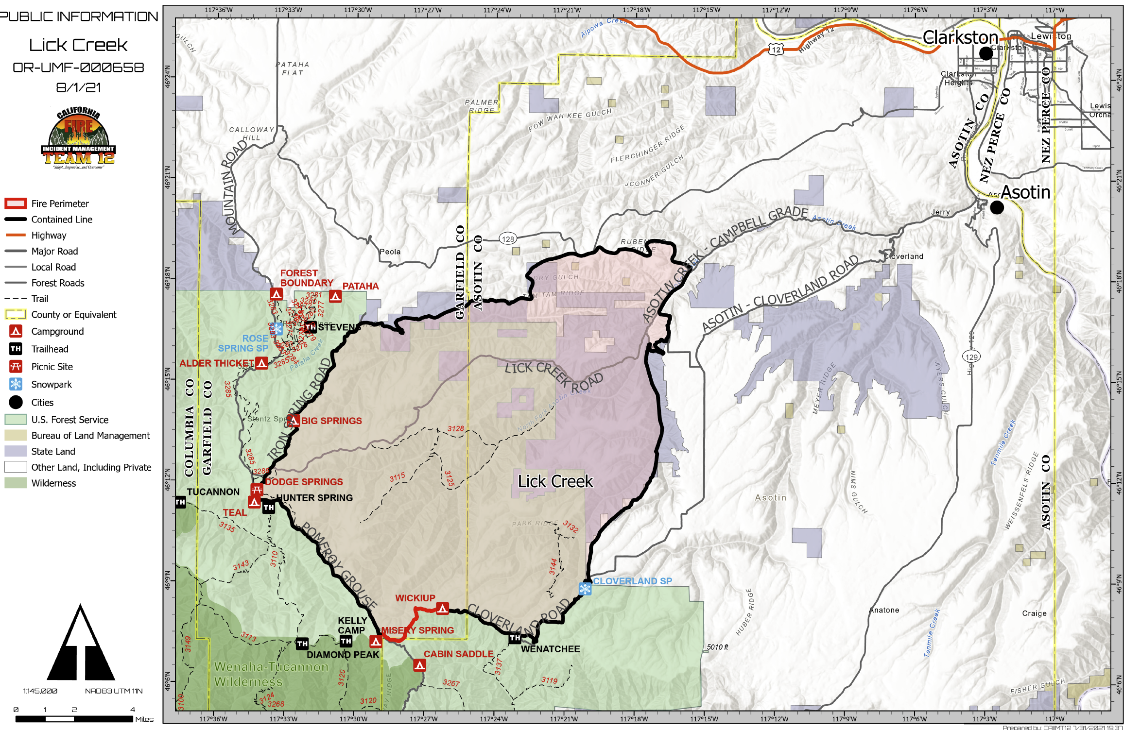
Lick Creek Fire: The fire area received 0.12" of rainfall yesterday aiding in firefighting efforts. A small, 6-acre, spot fire was fought aggressively and quickly contained. Crews will continue to mop up pockets of heat interior and patrol the perimeter until full containment is achieved. A Burned Area Emergency Response team continues its efforts for the fire. The team’s work will allow for long-range forecasting and preparation of mitigation measures in areas where the risk of runoff and flooding can take place.
Green Ridge Fire: Firefighters contained a twenty-two-acre spot fire on the west side of the 46 Road about two miles north of Godman Trailhead. Every effort is being made to protect the numerous values at risk to include Mill Creek Municipal Watershed, plantation reforestation sites, sensitive plants, recreation areas, fisheries, numerous cultural, archaeological, and historic sites, farming, high value agricultural lands, a RAWS site, and a repeater site are also threatened. Secondary control lines are also being established by improvement of existing roads, trails, and natural terrain features. Structure defense activities, including the use of protective fire wrap on the Historic Godman Guard Station and Fire Lookout were accomplished yesterday.
Firefighters continue working the strategy of the 'anchor and flanking', using the northwest portion of the fire as the anchor and constructing containment lines from that area along the north and west perimeter of the fire. Less active areas along the perimeter allow for placement of containment lines immediately adjacent to the fire perimeter. Areas unsafe for personnel to access or lack of personnel require burning out fuel between the main fire and containment lines.
Cloud cover and rainfall (measured at 0.05 by portable weather station) helped moderate fire activity yesterday. Air and ground resources are being used to minimize potential for additional fire spread, constructing direct containment lines where safe to do so. Contingency planning and implementation are ongoing with support from Regional Fire Managers. Over the last two days, additional resources arrived to provide enough personnel to staff a night shift. More fire crews and engines are still on order but due to several active wildfires in the west their availability is limited.
Weather and Smoke Information: This morning’s cloud cover will lift leading to increasing instability as the day progresses. The instability could bring thunderstorms that produce light and variable winds (5-10 MPH with a shift from the northwest in the afternoon) and scattered showers. The region can expect smoky conditions and elevated humidity levels. Information is available on Washington Smoke Blog at: https://wasmoke.blogspot.com/.
Evacuations: Level II Evacuation Notice issued on July 29th, by Columbia County’s sheriff’s office remains in effect for the area: south of the previous Level I evacuation in Columbia County. The Level II evacuation notice extends east to the forest boundary, including Bald Butte Mountain and south to the Columbia County-Wallowa County state border. The evacuation notice also extends west to the forest boundary and north to Chase Mountain. From Chase Mountain, it extends to Middle Point Trailhead to Midway Campground. Additionally, a Level I evacuation notice remains in effect for the following areas: everywhere north and west of Chase Mountain and Midway Camp in the forest boundary. If you have questions, please call the Columbia County Sheriff’s Office (509-382-1100; or 509-382-2518). The Level 1 evacuation remains in place in Garfield County. If you have questions, please call the Garfield County Emergency Management Director, Tina Meier, or Sheriff Drew Hyer (509-843-3494).
Closures: All Forest Service lands, roads, and trails in the Umatilla National Forest are closed. For more information, visit the Umatilla National Forest website: www.fs.usda.gov/Internet/FSE_DOCUMENTS/fseprd931174.pdf.
ADDITIONAL FIRE INFORMATION:
Lick Creek Fire Information: 509-780-6238
Lick Creek Fire InciWeb: inciweb.nwcg.gov/incident/7615/
Green Ridge Fire InciWeb:https://inciweb.nwcg.gov/incident/7628/
Green Ridge Fire Information: 509-542-7964
Lick Creek and Green Ridge Fire Update August 2 2021 800 am
Related Incident:
Publication Type: News
There will be community meeting this Wednesday night at the Dayton Best Western Conf. Room @ 7:30 p.m.
Lick Creek Fire: The Burn Area Emergency Response (BAER) Team has wrapped up their work on the Lick Creek Fire. Their assessment will be used for forecasting the preparation needs of the areas at greatest risk for runoff and flooding. This fire remains at 90% contained. Continued smoke will be visible as unburned pockets of vegetation inside the fire perimeter are consumed. Crews will continue to mop up pockets of heat interior and patrol until full containment is achieved.
Green Ridge Fire: The fire continued backing slowly toward the Ladybug Campground holding within primary containment lines. The night shift focused on patrol and monitoring of the fire edge taking action where needed to accomplish containment. Today’s operations may include firing along the 46 Road that will connect the Edmiston Springs and Spangler Creek sections. Aircraft will be assisting ground resources with retardant and water dropping runs to help minimize potential for additional fire spread, working the strategy of the 'anchor and flanking. Saturday’s cooler temperatures and rainfall (amounts from trace to 0.05 inches) helped to decrease fire activity in some areas of the fire. Every effort is being made to protect the numerous values at risk to include Mill Creek Municipal Watershed, plantation reforestation sites, sensitive plants, recreation areas, fisheries, numerous cultural, archaeological, and historic sites, farming, high value agricultural lands, a RAWS site, and a repeater site are also threatened. Secondary control lines are also being established by improvement of existing roads, trails, and natural terrain features.
Weather and Smoke Information: This morning’s cloud cover will decrease on Monday. It will be warmer with lower humidity. Afternoon temperatures will reach the mid 70’s over the higher ridges and in the mid 80’s in the valley bottoms. The humidity’s will generally range from 50 to 55 percent along the ridges and 30 to 35 percent in the valley bottoms. Winds will be light and variable. The region can expect smoky conditions and elevated humidity levels. Information is available on Washington Smoke Blog at: https://wasmoke.blogspot.com/.
Evacuations: Level II Evacuation Notice issued on July 29th, by Columbia County’s sheriff’s office remains in effect for the area: south of the previous Level I evacuation in Columbia County. The Level II evacuation notice extends east to the forest boundary, including Bald Butte Mountain and south to the Columbia County-Wallowa County state border. The evacuation notice also extends west to the forest boundary and north to Chase Mountain. From Chase Mountain, it extends to Middle Point Trailhead to Midway Campground. Additionally, a Level I evacuation notice remains in effect for the following areas: everywhere north and west of Chase Mountain and Midway Camp in the forest boundary. If you have questions, please call the Columbia County Sheriff’s Office (509-382-1100; or 509-382-2518). The Level 1 evacuation remains in place in Garfield County. If you have questions, please call the Garfield County Emergency Management Director, Tina Meier, or Sheriff Drew Hyer (509-843-3494).
Closures: All Forest Service lands, roads, and trails in the Umatilla National Forest are closed. For more information, visit the Umatilla National Forest website: www.fs.usda.gov/Internet/FSE_DOCUMENTS/fseprd931174.pdf.
Umatilla National Forest to reopen most lands to the public Aug 4 2021
Related Incident:
Publication Type: Closures
PENDLETON, Ore. (August 2, 2021) — With recent precipitation and reduced initial attack on new fires across the Forest, Umatilla National Forest officials will reopen much of the Forest on Wednesday, Aug. 4, including all Heppner and North Fork John Day Ranger District lands and part of the Walla Walla Ranger District. The Pomeroy Ranger District and northern portions of the Walla Walla Ranger District will remain closed.
Lick Creek and Green Ridge Fire Update August 3 2021 800 am
Related Incident:
Publication Type: News
There will be community meeting this Wednesday night at the Dayton Best Western Conf. Room @ 7:30 p.m.
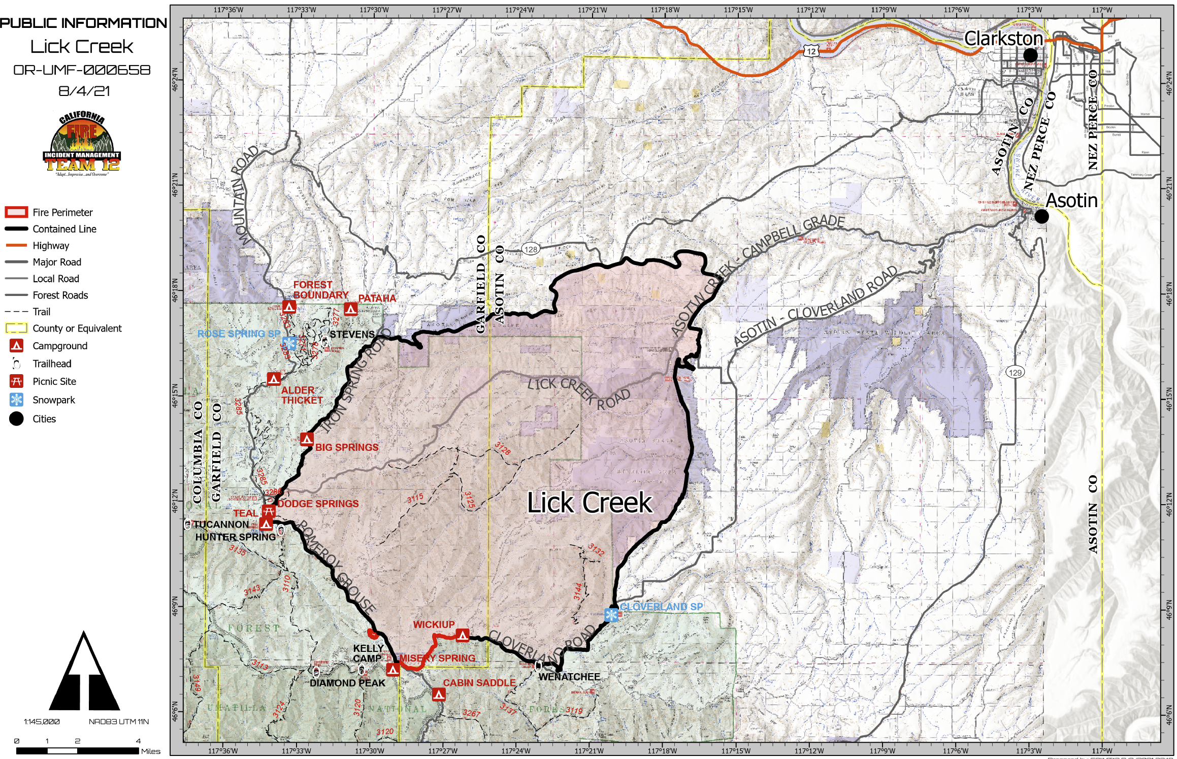
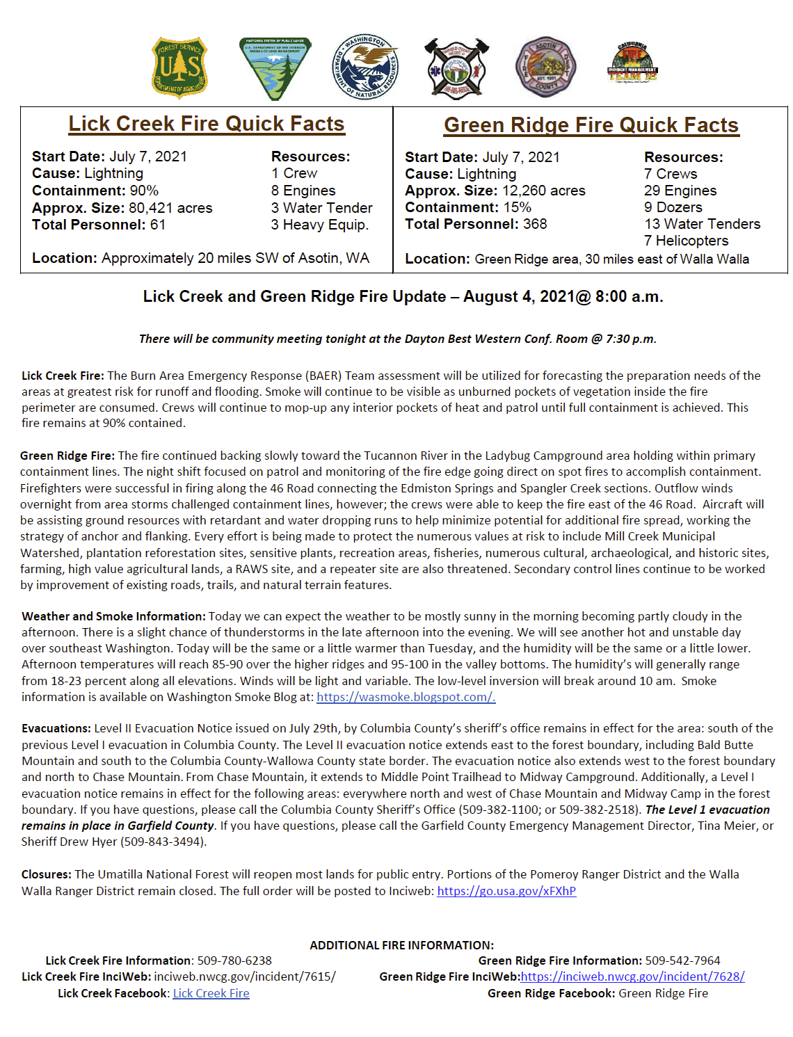
Lick Creek Fire: The Burn Area Emergency Response (BAER) Team assessment will be utilized for forecasting the preparation needs of the areas at greatest risk for runoff and flooding. Continued smoke will be visible as unburned pockets of vegetation inside the fire perimeter are consumed. Crews will continue to mop-up any interior pockets of heat and patrol until full containment is achieved. This fire remains at 90% contained.
Green Ridge Fire: The fire continued backing slowly toward the Tucannon River in the Ladybug Campground area holding within primary containment lines. The night shift focused on patrol and monitoring of the fire edge taking action where needed to accomplish containment. Today’s operations may include firing along the 46 Road that will connect the Edmiston Springs and Spangler Creek sections. Aircraft will be assisting ground resources with retardant and water dropping runs to help minimize potential for additional fire spread, working the strategy of anchor and flanking. It will be warmer today with temperatures in the 70’s along the ridges and 90’s in the valley bottoms. Every effort is being made to protect the numerous values at risk to include Mill Creek Municipal Watershed, plantation reforestation sites, sensitive plants, recreation areas, fisheries, numerous cultural, archaeological, and historic sites, farming, high value agricultural lands, a RAWS site, and a repeater site are also threatened. Secondary control lines continue to be worked by improvement of existing roads, trails, and natural terrain features.
Update Lick Creek Green Ridge Fires August 4 2021
Related Incident:
Publication Type: News
Lick Creek and Green Ridge Fire Update – August 4, 2021@ 8:00 a.m.
There will be community meeting tonight at the Dayton Best Western Conf. Room @ 7:30 p.m.
Lick Creek Fire: The Burn Area Emergency Response (BAER) Team assessment will be utilized for forecasting the preparation needs of the areas at greatest risk for runoff and flooding. Smoke will continue to be visible as unburned pockets of vegetation inside the fire perimeter are consumed. Crews will continue to mop-up any interior pockets of heat and patrol until full containment is achieved. This fire remains at 90% contained.
Green Ridge Fire: The fire continued backing slowly toward the Tucannon River in the Ladybug Campground area holding within primary containment lines. The night shift focused on patrol and monitoring of the fire edge going direct on spot fires to accomplish containment. Firefighters were successful in firing along the 46 Road connecting the Edmiston Springs and Spangler Creek sections. Outflow winds overnight from area storms challenged containment lines, however; the crews were able to keep the fire east of the 46 Road. Aircraft will be assisting ground resources with retardant and water dropping runs to help minimize potential for additional fire spread, working the strategy of anchor and flanking. Every effort is being made to protect the numerous values at risk to include Mill Creek Municipal Watershed, plantation reforestation sites, sensitive plants, recreation areas, fisheries, numerous cultural, archaeological, and historic sites, farming, high value agricultural lands, a RAWS site, and a repeater site are also threatened. Secondary control lines continue to be worked by improvement of existing roads, trails, and natural terrain features.
Weather and Smoke Information: Today we can expect the weather to be mostly sunny in the morning becoming partly cloudy in the afternoon. There is a slight chance of thunderstorms in the late afternoon into the evening. We will see another hot and unstable day over southeast Washington. Today will be the same or a little warmer than Tuesday, and the humidity will be the same or a little lower. Afternoon temperatures will reach 85-90 over the higher ridges and 95-100 in the valley bottoms. The humidity’s will generally range from 18-23 percent along all elevations. Winds will be light and variable. The low-level inversion will break around 10 am. Smoke information is available on Washington Smoke Blog at: https://wasmoke.blogspot.com/.
Evacuations: Level II Evacuation Notice issued on July 29th, by Columbia County’s sheriff’s office remains in effect for the area: south of the previous Level I evacuation in Columbia County. The Level II evacuation notice extends east to the forest boundary, including Bald Butte Mountain and south to the Columbia County-Wallowa County state border. The evacuation notice also extends west to the forest boundary and north to Chase Mountain. From Chase Mountain, it extends to Middle Point Trailhead to Midway Campground. Additionally, a Level I evacuation notice remains in effect for the following areas: everywhere north and west of Chase Mountain and Midway Camp in the forest boundary. If you have questions, please call the Columbia County Sheriff’s Office (509-382-1100; or 509-382-2518). The Level 1 evacuation remains in place in Garfield County. If you have questions, please call the Garfield County Emergency Management Director, Tina Meier, or Sheriff Drew Hyer (509-843-3494).
Closures: The Umatilla National Forest will reopen most lands for public entry. Portions of the Pomeroy Ranger District and the Walla Walla Ranger District remain closed. The full order will be posted to Inciweb: https://go.usa.gov/xFXhP
ADDITIONAL FIRE INFORMATION:
Lick Creek Fire Information: 509-780-6238
Lick Creek Fire InciWeb: inciweb.nwcg.gov/incident/7615/
Green Ridge Fire Information: 509-542-7964
Green Ridge Fire InciWeb:https://inciweb.nwcg.gov/incident/7628/ Lick Creek Facebook: Lick Creek Fire Green Ridge Facebook: Green Ridge Fire
Lick Creek and Green Ridge Fire Update August 5 2021 800 am
Related Incident:
Publication Type: News
Lick Creek Fire: A plan is being put together for the needs of the areas at greatest risk for runoff and flooding as proposed in the BAERTeam assessment. Smoke will continue to be visible as unburned pockets of vegetation inside the fire perimeter are consumed. Crews willcontinue to mop-up any interior pockets of heat and patrol until full containment is achieved. This fire remains at 90% contained.
Green Ridge Fire: The fire remains within primary containment lines along the Tucannon River in the Ladybug Campground area. The nightshift focused on holding the fire south of the Tucannon River. Patrol and monitoring of the fire edge continues, one spot fire was locatedover the edge of this line, going direct crews were able to quickly pick up and contain it. Favorable winds overnight assisted firefighters byincreasing the depth of the containment along the 46 Road. Aircraft will be assisting ground resources with retardant and water droppingruns to help minimize potential for additional fire spread, working the strategy of anchor and flanking. Every effort is being made to protectthe numerous values at risk to include Mill Creek Municipal Watershed, plantation reforestation sites, sensitive plants, recreation areas,fisheries, numerous cultural, archaeological, and historic sites, farming, high value agricultural lands, a RAWS site, and a repeater site arealso threatened. Secondary control lines continue to be worked by improvement of existing roads, trails, and natural terrain features.
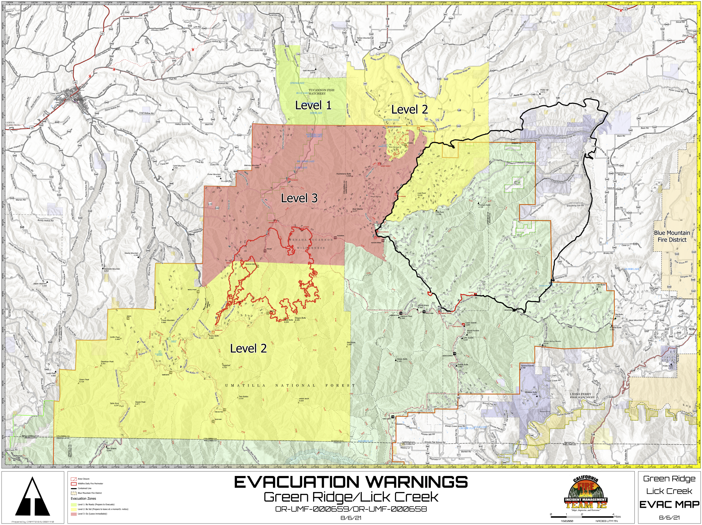
UPDATED EVACUATION NOTICE
Related Incident:
Publication Type: News
EVACUATION UPDATE:
Garfield County current evacuations:
A Level 3 evacuation notice for the following areas:
•Northwest corner of the Columbia and Garfield County border south to the Tucannon River Trail. Diagonally to the southeast along the Tucannon River Trail and north along the bear creek trail to the intersection of the 40 road. This will continue north on the westside of the 42 road to Pataha Spur Rd in the area of Iron Springs. Around the 040 road to the 4016 road, following the 4016 road to the 40 road and north to the forest boundary. •To include the Stentz Spring and Clear Water communities.
A Level 2 evacuation notice for the following areas:
•Starting from the northwest area of the Columbia County line on the Blind Grade Road extending south to Umatilla National Forest boundary east to the Baker Pond Campground. South on the 40 road to the 4016 road, 4016 road around to 040 Road to 42 Road. Continues south on the eastside of the 42 Road to Lickford Road (41 Road) and northeast to Asotin County line. North on the county line to Knotgrass Ridge Road west to include Kimble Road area. Kimble Road west to the Highway 128 going northeast to Bosley Grade Road. Bosley Grade Road to Mountain Road continuing to the intersection of Lineville Ridge Road to the Columbia County line.
•This includes the Stentz Springs, Rose Spring and Baker Pond communities
Columbia County current evacuations:
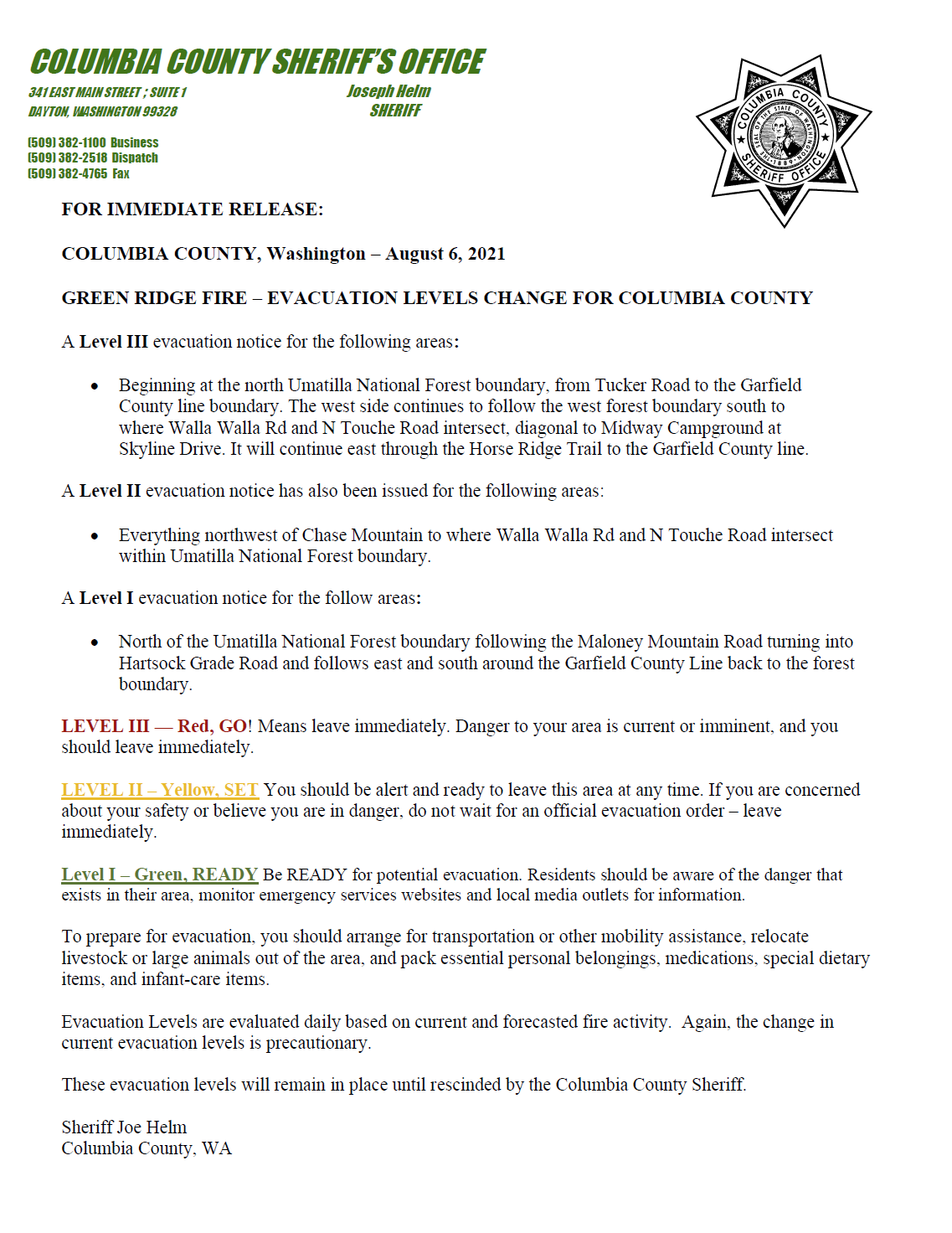
A Level III evacuation notice for the following areas:
•Beginning at the north Umatilla National Forest boundary, from Tucker Road to the Garfield County line boundary. The west side continues to follow the west forest boundary south to where Walla Walla Rd and N Touche Road intersect, diagonal to Midway Campground at Skyline Drive. It will continue east through the Horse Ridge Trail to the Garfield County line.
A Level II evacuation notice has also been issued for the following areas:
•Everything northwest of Chase Mountain to where Walla Walla Rd and N Touche Road intersect within Umatilla National Forest boundary.
A Level I evacuation notice for the following areas:
•North of the Umatilla National Forest boundary following the Maloney Mountain Road turning into Hartsock Grade Road and follows east and south around the Garfield County Line back to the forest boundary.
Update Lick Creek Green Ridge Fire August 7 2021
Related Incident:
Publication Type: News
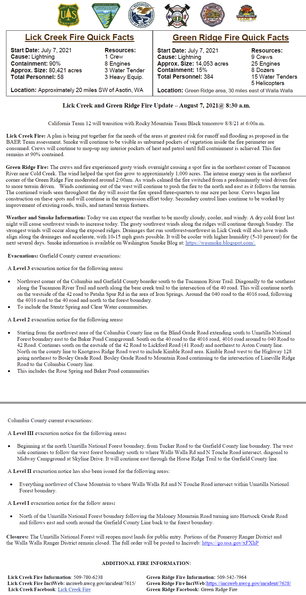
Lick Creek and Green Ridge Fire Update – August 7, 2021@ 8:30 a.m.
California Team 12 will transition with Rocky Mountain Team Black tomorrow 8/8/21 at 6:00a.m.
Lick Creek Fire: A plan is being put together for the needs of the areas at greatest risk for runoff and flooding as proposed in the BAER Team assessment. Smoke will continue to be visible as unburned pockets of vegetation inside the fire perimeter are consumed. Crews will continue to mop-up any interior pockets of heat and patrol until full containment is achieved. This fire remains at 90% contained.
Green Ridge Fire: The crews and fire experienced gusty winds overnight causing a spot fire in the northeast corner of Tucannon River near Cold Creek. The wind helped the spot fire grow to approximately 1,000 acres. The intense energy seen in the northeast corner of the Green Ridge Fire moderated around 2:00am. As winds calmed the fire switched from a predominantly wind driven fire to more terrain driven. Winds continuing out of the west will continue to push the fire to the north and east as it follows the terrain. The continued winds seen throughout the day will assist the fire spread three-quarters to one acre per hour. Crews began line construction on these spots and will continue in the suppression effort today. Secondary control lines continue to be worked by improvement of existing roads, trails, and natural terrain features.
Weather and Smoke Information: Today we can expect the weather to be mostly cloudy, cooler, and windy. A dry cold front last night will cause southwest winds to increase today. The gusty southwest winds along the ridges will continue through Sunday. The strongest winds will occur along the exposed ridges. Drainages that run southwest-northwest in Lick Creek will also have winds align along the drainages and accelerate, with 10-15 mph gusts possible. It will be cooler with higher humidity (5-10 percent) for the next several days. Smoke information is available on Washington Smoke Blog at: https://wasmoke.blogspot.com/.
Evacuations: Garfield County current evacuations:
A Level 3 evacuation notice for the following areas:
Northwest corner of the Columbia and Garfield County boarder south to the Tucannon River Trail. Diagonally to the southeast along the Tucannon River Trail and north along the bear creek trail to the intersection of the 40 road. This will continue north on the westside of the 42 road to Pataha Spur Rd in the area of Iron Springs. Around the 040 road to the 4016 road, following the 4016 road to the 40 road and north to the forest boundary.
To include the Stentz Spring and Clear Water communities.
A Level 2 evacuation notice for the following areas:
Starting from the northwest area of the Columbia County line on the Blind Grade Road extending south to Umatilla National Forest boundary east to the Baker Pond Campground. South on the 40 road to the 4016 road, 4016 road around to 040 Road to 42 Road. Continues south on the eastside of the 42 Road to Lickford Road (41 Road) and northeast to Aston County line. North on the county line to Knotgrass Ridge Road west to include Kimble Road area. Kimble Road west to the Highway 128 going northeast to Bosley Grade Road. Bosley Grade Road to Mountain Road continuing to the intersection of Lineville Ridge Road to the Columbia County line.
This includes the Rose Spring and Baker Pond communities
Columbia County current evacuations:
A Level III evacuation notice for the following areas:
Beginning at the north Umatilla National Forest boundary, from Tucker Road to the Garfield County line boundary. The west side continues to follow the west forest boundary south to where Walla Walla Rd and N Touche Road intersect, diagonal to Midway Campground at Skyline Drive. It will continue east through the Horse Ridge Trail to the Garfield County line.
A Level II evacuation notice has also been issued for the following areas:
Everything northwest of Chase Mountain to where Walla Walla Rd and N Touche Road intersect within Umatilla National Forest boundary.
A Level I evacuation notice for the follow areas:
North of the Umatilla National Forest boundary following the Maloney Mountain Road turning into Hartsock Grade Road and follows east and south around the Garfield County Line back to the forest boundary.
Closures: The Umatilla National Forest will reopen most lands for public entry. Portions of the Pomeroy Ranger District and the Walla Walla Ranger District remain closed. The full order will be posted to Inciweb: https://go.usa.gov/xFXhP
ADDITIONAL FIRE INFORMATION:
Lick Creek Fire Information: 509-780-6238 Green Ridge Fire Information: 509-542-7964
Lick Creek Fire InciWeb: inciweb.nwcg.gov/incident/7615/ Green Ridge Fire InciWeb:https://inciweb.nwcg.gov/incident/7628/
Lick Creek Facebook: Lick Creek Fire Green Ridge Facebook: Green Ridge Fire
August 8 Green Ridge Fire Lick Creek Fire Update
Related Incident:
Publication Type: News
Green Ridge and Lick Creek Fire Update
Sunday, August 8, 2021, 10:00 a.m.
Rocky Mountain Incident Management Team Black
Troy Hagan, Incident Commander
Green Ridge Fire Statistics:
Size: 20,259 acres
Containment: 15%
Location: 30 miles east of Walla Walla
Reported: July 7, 2021
Cause: Lightning
Lick Creek Fire Information:
Size: 80,421 acres
Containment: 90%
Location: 20 miles southwest of Asotin, WA
Reported: July 7, 2021
Cause: Lightning
Winds Push Green Ridge Fire to Merge with Lick Creek Fire
Current Situation: Green Ridge Fire: The Green Ridge Fire grew to 20,259 acres, representing a growth of 4,869 acres. The fire remains 15% contained. Yesterday, gusty winds caused the fire to grow steadily to the east and north beginning early in the afternoon. The Green Ridge Fire to grew onto the Lick Creek Fire’s contained perimeter on the east and across the Tucannon River to the north, spotting over the 22 Road. The growth into the previously burned area gives firefighters a good anchor point to construct line and stop the fire’s progress to the east. When the winds died down in the early hours of the night, crews were able to engage the spots north of the 22 road and will continue those suppression efforts today. Secondary control lines, or contingency lines, will be constructed by improving existing roads, trails, and natural terrain features. Crews continue making progress on the containment line southwest of the Panjab campground and patrolling lines on the southwest portion of the fire.
Current Situation: Lick Creek Fire: The Lick Creek Fire remains 80,421 acres and 90% contained. Smoke will continue to be visible as unburned pockets of vegetation inside the fire perimeter are consumed. Crews will continue to mop-up any interior pockets of heat and patrol lines as they can safely do so.
Rocky Mountain Team Black assumed command of the Green Ridge Fire and Lick Creek Fire today at 6:00 a.m. Team Black will continue to utilize the established information channels, specifically phone numbers, Facebook, and Inciweb pages for both fires.
Weather & Smoke Information: Today we can expect the weather to be mostly cloudy, cooler, and windy. A dry cold front last night will cause southwest winds to increase today. The gusty southwest winds along the ridges will continue through Sunday. The strongest winds will occur along the exposed ridges. Drainages that run southwest-northwest in Lick Creek will also have winds align along the drainages and accelerate, with 10-15 mph gusts possible. It will be cooler with higher humidity (5-10 percent) for the next several days. Smoke information is available on Washington Smoke Blog at: https://wasmoke.blogspot.com/
Forest Closures: The Umatilla National Forest reopened many lands for public entry. Portions of the Pomeroy Ranger District and the Walla Walla Ranger District near the Green Ridge and Lick Creek fires remain closed. The full order is available on Inciweb: https://go.usa.gov/xFXhP
Evacuations: Garfield County has current Level 2 and Level 3 evacuations in place. Columbia County has current Level 3, Level 2, and Level 1 evacuations in place. For more information on evacuations, please visit https://go.usa.gov/xFQJ2 for full information.
Temporary Flight Restrictions: A Temporary Flight Restriction is in place over the Green Ridge Fire and Lick Creek Fire. Wildfires are a No Drone Zone. If you fly, we can’t. Whenever a drone is spotted near the fire all aircraft are grounded until we can be sure the drone is clear of the area. For more information, visit http://knowbeforeyoufly.org.
Green Ridge Fire Information:
Information Office: (509) 542-7964
Email: 2021.GreenRidge@firenet.gov
Inciweb: https://inciweb.nwcg.gov/incident/7628/
Facebook: www.facebook.com/GreenRidgeFire2021
Lick Creek Fire Information:
Information Office: (509) 780-6238
Email: 2021.LickCreek@firenet.gov
Inciweb: https://inciweb.nwcg.gov/incident/7615/
Facebook: www.facebook.com/LickCreekFire
August 9 Green Ridge and Lick Creek Fire Update
Related Incident:
Publication Type: News
Green Ridge and Lick Creek Fire Update
Monday, August 9, 2021, 9:00 a.m.
Rocky Mountain Incident Management Team Black
Troy Hagan, Incident Commander
Green Ridge Fire Statistics:
Size: 23,126 acres
Containment: 15%
Total Personnel: 363
Location: 30 miles east of Walla Walla
Reported: July 7, 2021Cause: Lightning
Lick Creek Fire Statistics:
Size: 80,421 acres
Containment: 90%
Total Personnel: 82
Location: 20 miles southwest of Asotin, WA
Reported: July 7, 2021
Cause: Lightning
Yesterday’s Weather Moderates Fire Behavior on Green Ridge Fire
Current Situation: Green Ridge Fire: The Green Ridge Fire grew to 23,126 acres and remains 15% contained. Lighter winds yesterday allowed firefighters to focus efforts on the northeast side of the fire and the spot fires north of the 22 Road, successfully limiting the fire’s spread in that area. Where the Green Ridge Fire burned into the Lick Creek Fire perimeter, fire activity slowed significantly due to a lack of available fuels.
Today, crews will take advantage of the cooler weather and continue to strengthen the firelines north of the 22 Road exploring all possible containment options as well as additional contingency lines. Firefighters are considering firing operations to remove unburned pockets of fuel on the northeast side of the fire to the south of 22 Road. This operation is planned to occur over several days and is contingent on weather and fuel conditions. The operation will occur only if conditions are favorable. Crews will continue to strengthen the containment lines southwest of the Panjab campground and patrol firelines on the southwest portion of the fire.
Current Situation: Lick Creek Fire: The Lick Creek Fire remains 80,421 acres and 90% contained. Smoke will continue to be visible as unburned pockets of vegetation inside the fire perimeter are consumed. Crews will continue to mop-up any interior pockets of heat and patrol lines as they can safely do so.
Weather & Smoke Information: Today’s weather is expected to be more favorable with low winds, seasonal temperatures, and lower humidity. Today will begin a warming trend that will continue through the week. Temperatures will be near seasonal with highs between 65 and 70 degrees along the ridges and near 80 degrees in the valley bottoms. Winds will be light, coming from the northwest at 4-8 mph. Smoke information is available on Washington Smoke Blog at: https://wasmoke.blogspot.com/
Forest Closures: The Umatilla National Forest reopened many lands for public entry. Portions of the Pomeroy Ranger District and the Walla Walla Ranger District near the Green Ridge and Lick Creek fires remain closed. The full closure order and map is available on InciWeb: https://go.usa.gov/xFXhP
Evacuations: Garfield County has current Level 2 and Level 3 evacuations in place. Columbia County has current Level 3, Level 2, and Level 1 evacuations in place. For more information on evacuations, please visit https://go.usa.gov/xFQJ2 for full information.
Temporary Flight Restrictions: A Temporary Flight Restriction is in place over the Green Ridge Fire and Lick Creek Fire. Wildfires are a No Drone Zone. If you fly, we can’t. Whenever a drone is spotted near the fire all aircraft are grounded until we can be sure the drone is clear of the area. For more information, visit http://knowbeforeyoufly.org.
Green Ridge Fire Information:
Information Office: (509) 542-7964
Email: 2021.GreenRidge@firenet.gov
InciWeb: https://inciweb.nwcg.gov/incident/7628/
Facebook: www.facebook.com/GreenRidgeFire2021
Lick Creek Fire Information:
Information Office: (509) 780-6238
Email: 2021.LickCreek@firenet.gov
InciWeb: https://inciweb.nwcg.gov/incident/7615/
Facebook: www.facebook.com/LickCreekFire