
Incident Publication
Bootleg Fire Daily Update July 27
Related Incident:
Publication Type: News
Bootleg Update July 27, 2021
Location: 28 miles northeast of Klamath Falls, OR Size: 410,731 acres
Personnel: 2,099 Containment: 53%
(Klamath Falls, OR) – This morning the Alaska Incident Management Team assumed leadership of the Bootleg Fire after several days of transition with the other teams. Incident Commander Norm McDonald thanked the Pacific Northwest Team 2, Oregon State Fire Marshal Red Team, and Oregon Department of Forestry Team 1 for leaving us in such a good position. “We will continue operations with a focus on the safety of the community and our firefighters,” said Commander McDonald. “We’re continuing with community and agency partners to suppress the fire as effectively as possible to protect timber, ranchlands, and other local values.”
As of yesterday, the southern boundary line continued to hold; this area remains in patrol status. Operations focus on eliminating remaining hot spots and burning out fuel pockets to widen the perimeter and secure the fire’s edges.
Rugged terrain on the northwest side of the fire makes suppression slow going. There is a concentration of snags, downed logs, and slash that provide heavy fuels to the fire. And while progress is being made, this area continues to be a challenge. Favorable weather today will create a good window for direct attack.
On the northeast side, crews extinguished a small spot fire of less than 3 acres that jumped the perimeter. With the changing weather conditions, spotting potential should decrease today, but crews will remain vigilant and respond quickly to threats as they arise.
Temperatures are expected to cool today with an increase in humidity and likelihood of isolated showers continuing through tomorrow. The mild weather will have a short-term calming effect on the fire behavior. But due to the extremely dry conditions and fuels, as the week progresses and temperatures rise, aggressive fire behavior is likely to quickly rebound.
Yesterday, a thorough damage assessment was finalized that tallied the number of buildings damaged and destroyed in Klamath and Lake counties. This fire has a very large footprint and it is important to fire managers that the impact to people’s homes and other structures be accurately examined and counted.
Surveying experts were able to safely access remote areas where the fire has caused significant damage and provide updated reporting to fire managers. In total, 161 residences were destroyed and 247 outbuildings. In addition, 342 vehicles were destroyed in the fire. These numbers may increase as firefighters and surveyors continue to work through the interior of the fire. For additional information on submitting insurance claims after a wildfire, please visit https://dfr.oregon.gov/insure/home/storm/Pages/wildfires.aspx or call the state’s team of consumer advocates at 888-877-4894 (toll-free).
Evacuations: Evacuations are dynamic. An interactive map of evacuation levels in Lake and Klamath Counties is available at tinyurl.com/bootlegevac
Red Cross Evacuation Shelters: For information or assistance: 1-800-Red-Cross (www.redcrossblog.org/disaster)
Closures: The Fremont-Winema National Forest is closed to the public in the fire area. The full closure order and map are available at https://www.fs.usda.gov/alerts/fremont-winema/alerts-notices.
Smoke: Lower air pressure is expected today, meaning the atmosphere itself will be a little more unstable. The more unstable the atmosphere, the easier it is for air and smoke to rise. There shouldn't be as much smoke on the ground as there has been over the past several days. This is reflected in today's forecast, as a lot of sites should see generally good air quality today. Pockets of moderate air quality will be possible throughout the day. See: fires.airfire.org/outlooks/southcentraloregon.
Fire Information Public Phone: 541-482-1331 Fire Information Media Phone: 971-727-7255
Inciweb: inciweb.nwcg.gov/incident/7609/ Facebook: www.facebook.com/BootlegFireInfo
Twitter: twitter.com/BootlegFireInfo Hashtags: #BootlegFire #FireYear2021
Actualizacion del Incendio de Bootleg Julio 27 2021
Related Incident:
Publication Type: News
Actualizacion del Incendio de Bootleg Julio 27, 2021
Localización: 28 millas noreste de Klamath Falls, OR Tamaño: 410,731 acres
Personal: 2,099 Contención: 53%
(Klamath Falls, OR) – Esta mañana, el Alaska Incident Management Team asumió el liderazgo del incendio de Bootleg después de varios días de transición con los otros equipos. El comandante del Incidente Norm McDonald agradeció al Pacific Northwest Team 2, Oregon State Fire Marshal Red Team, y Oregon Department of Forestry Team 1 por dejarnos en una posición tan buena. "Continuaremos las operaciones con un enfoque en la seguridad de la comunidad y nuestros bomberos", dijo el comandante McDonald. "Continuamos con la comunidad y agencias asociadas para sofocar el fuego de la manera más eficaz para proteger la madera, los ranchos y otros valores locales".
A partir de ayer, la línea fronteriza del sur se mantuvo firme; esta área permanece en estado de patrulla. Las operaciones se enfocan en eliminar los puntos calientes restantes y quemar las áreas sin quemar para ensanchar el perímetro y asegurar los bordes del fuego.
El terreno accidentado en el lado noroeste del fuego hace que la extinción sea lenta. Hay una concentración de troncos, troncos caídos y tajos que se prestan a combustibles pesados del incendio. Y mientras hay progreso, esta área sigue siendo un desafío. El clima favorable de hoy creará una buena ventana para un ataque directo.
En el lado noreste, los equipos extinguieron un pequeño foco secundario menos de 3 acres que saltó el perímetro. Con las condiciones climáticas cambiando, el potencial de focos secundarios debería disminuir hoy, pero las cuadrillas permanecerán atentas y responderán rápidamente a las amenazas a medida que surjan.
Hoy, se espera que las temperaturas se enfríen con un aumento de la humedad y la probabilidad de que continúen lluvias aisladas hasta mañana. El clima templado tendrá un efecto calmante a corto plazo sobre el comportamiento del fuego. Pero debido a las condiciones extremadamente secas y los combustibles, a medida que avanza la semana y aumentan las temperaturas, es probable que el comportamiento agresivo del fuego se recupere rápidamente.
Ayer, se finalizó una evaluación exhaustiva de las perdidas, contando los edificios dañados y destruidos por el incendio en los condados de Klamath y Lake. Este incendio está dejando un impacto significativo, es importante para los administradores evaluar con precisión los daños en casas y otras estructuras. Los expertos en topografía pudieron acceder de manera segura a áreas remotas donde el incendio ha causado daños significativos y facilitar informes actualizados a los administradores de incendios. En total, 161 residencias fueron destruidas y 247 dependencias. Además, 342 vehículos fueron destruidos en el incendio. Estos números pueden aumentar a medida que los bomberos y topógrafos continúen trabajando en el interior del incendio. Para obtener información adicional sobre cómo presentar reclamaciones de seguros después de un incendio forestal, visite https://dfr.oregon.gov/insure/home/storm/Pages/wildfires.aspx o llame al equipo estatal de defensores del consumidor al 888-877-4894 (número gratuito).
Evacuaciones: Evacuaciones son dinámicas. Mapa interactivo de los niveles de evacuación en los condados de Lake y Klamath disponible en tinyurl.com/bootlegevac
Refugios de evacuación de la Cruz Roja: Para obtener información o asistencia: 1-800-Red-Cross, (www.redcrossblog.org/disaster).
Cierres: El Bosque Nacional Fremont-Winema está cerrado al público en el área del incendio. Mapa y la orden completa están disponibles en inciweb.nwcg.gov/incident/7609/.
Pronostico del humo: Hoy, se espera una presión de aire más baja lo que significa que la atmósfera será un poco más inestable. Cuanto más inestable es la atmósfera, más fácil es que el aire y el humo se eleven. No debería haber tanto humo en el suelo como en los últimos días. Esto se refleja en el pronóstico de hoy, ya que muchos sitios deberían ver hoy una buena calidad del aire en general. Durante todo el día pueden haber ciertas áreas con calidad del aire moderada. Visite: fires.airfire.org/outlooks/southcentraloregon.
Información sobre el incendio para el público: 541-482-1331 Información del incendio para la media: 971-727-7255
Inciweb: inciweb.nwcg.gov/incident/7609/ Facebook: www.facebook.com/BootlegFireInfo
Twitter: twitter.com/BootlegFireInfo Hashtags: #BootlegFire #FireYear2021
Bootleg Fire Daily Update July 28
Related Incident:
Publication Type: News
Bootleg Update July 28, 2021
Location: 28 miles northeast of Klamath Falls, OR Size: 413,400 acres
Personnel: 1,924 Containment: 53%
(Klamath Falls, OR) – The west side of the fire received steady, light rain that allowed more direct attack on the fire’s edge yesterday and overnight. The rain significantly moderated fire behavior. Fine fuels are most affected by the moisture, although larger diameter fuels are still critically dry. Some isolated torching occurred yesterday in heavy fuels, but spotting was much reduced.
On the east side of the fire, crews continued to mop up after the spot fire from yesterday. With the added moisture they have no concerns about that area today. The Oregon National Guard crews are working on the east flank of the fire area to secure the perimeter and put out any hot spots. Crews are completing lines on the fire perimeter near the Old Trunk road around the burned area of the 2018 Watson Creek Fire.
Along the Sycan River there is still active fire in the treed riparian area, but the wetter areas of the Sycan Marsh will likely remain unburned. The southern and western portions of the fire have shown little fire activity and remain in monitor and patrol status.
“The cooler temperatures and precipitation yesterday were a welcome change,” said Incident Meteorologist Chris Foltz. “A wetting rain fell yesterday dropping as much as 0.6 of an inch on the western area of the fire. The eastern side was a bit drier, but still received a tenth of an inch. Not all areas of the fire received rain, but overall the cooler, more humid conditions are beneficial for the firefighting crews.” The rain and cloud cover kept humidity levels above 60%. The rain tapered off overnight, although isolated thunderstorms are still possible, especially in the northwest region, over the next few days. Warmer temperatures will return and humidity will decrease starting today and over the next few days, so crews are watching for increased fire activity.
Evacuations: Evacuations are dynamic. Klamath County has dropped all evacuation notices; however, the Fremont-Winema National Forest remains closed. Lake County released an announcement of lowered evacuation levels. The most effective way to view the new designation boundaries is on the interactive map available at tinyurl.com/bootlegevac
Red Cross Evacuation Shelters: For information or assistance: 1-800-Red-Cross (www.redcrossblog.org/disaster)
Insurance Assistance: For additional information on submitting insurance claims after losing your home or property to a wildfire, please visit https://dfr.oregon.gov/insure/home/storm/Pages/wildfires.aspx or call the state’s team of consumer advocates at 888-877-4894 (toll-free).
Closures: The Fremont-Winema National Forest is closed to the public in the fire area. The full closure order and map are available at https://www.fs.usda.gov/alerts/fremont-winema/alerts-notices.
Smoke: Yesterday's rainfall helped mitigate some of the smoke. Drier conditions are forecast to return today. Overall, air quality will remain generally good to moderate. Klamath Falls and Paisley are the exceptions; Klamath Falls could see periods of USG air quality, and Paisley could see periods as high as Unhealthy today. See: fires.airfire.org/outlooks/southcentraloregon.
Fire Information Public Phone: 541-482-1331 Fire Information Media Phone: 971-727-7255
Inciweb: inciweb.nwcg.gov/incident/7609/ Facebook: www.facebook.com/BootlegFireInfo
Twitter: twitter.com/BootlegFireInfo Hashtags: #BootlegFire #FireYear2021
Actualizacion del Incendio de Bootleg Julio 28 2021
Related Incident:
Publication Type: News
Actualizacion del Incendio de Bootleg Julio 28, 2021
Localización: 28 millas noreste de Klamath Falls, OR Tamaño: 413,400 acres
Personal: 1,924 Contención: 53%
(Klamath Falls, OR) – Ayer, el lado oeste del fuego recibió una lluvia constante y ligera que permitió un ataque más directo en el borde del fuego. La lluvia moderó significativamente el comportamiento del fuego. Los combustibles finos son los más afectados por la humedad, aunque los combustibles de mayor diámetro todavía están críticamente secos. Ayer originaron algunos fuegos de antorcha aislados en los combustibles pesados, pero la producción de focos secundarios se redujo bastante.
En el lado este del incendio, las cuadrillas continuaron liquidando el foco secundario de ayer. Con la humedad añadida, hoy no les preocupa esa zona. Los equipos de la Guardia Nacional de Oregón están trabajando en el flanco este del área del incendio para asegurar el perímetro y extinguir los puntos calientes. Los equipos están completando líneas en el perímetro del incendio cerca de la carretera Old Trunk alrededor del área quemada del incendio de Watson Creek del 2018.
A lo largo del río Sycan todavía hay fuego activo en el área ribereña arbolada, pero las áreas más húmedas del Sycan Marsh probablemente permanecerán sin quemar. Las áreas sur y oeste del incendio han mostrado poca actividad y permanecen en estado de vigilancia y patrulla.
"Las temperaturas más frías y las precipitaciones de ayer fueron un cambio bienvenido", dijo el meteorólogo de incidentes Chris Foltz. “Ayer la lluvia ayudo a mojar el área con una cantidad de hasta 0.6 de pulgada en el área oeste del incendio. El lado este estaba un poco más seco, pero todavía recibió una décima de pulgada. No todas las áreas del incendio recibieron lluvia, pero en general, las condiciones más frías y húmedas son beneficiosas para los equipos de bomberos". La lluvia y la nubosidad mantuvieron los niveles de humedad por encima del 60%. La lluvia disminuyó durante la noche, aunque todavía es posible que se produzcan tormentas eléctricas aisladas, especialmente en la región noroeste, durante los próximos días. Las temperaturas más cálidas regresarán y la humedad disminuirá a partir de hoy y durante los próximos días, por lo cual las cuadrillas están atentos a un aumento en la actividad de incendios.
Evacuaciones: Evacuaciones son dinámicas. El condado de Klamath ha terminado todos los avisos de evacuación; sin embargo, el Bosque Nacional Fremont-Winema permanece cerrado. El condado de Lake publicó un anuncio de niveles de evacuación reducidos. La forma más eficaz de ver las áreas y bordes de las nuevas designaciones de evacuaciones es en el mapa interactivo disponible en tinyurl.com/bootlegevac.
Refugios de evacuación de la Cruz Roja: Para obtener información o asistencia: 1-800-Red-Cross, (www.redcrossblog.org/disaster).
Asistencia de seguros: Para obtener información adicional sobre cómo presentar reclamaciones de seguros después de perder su casa o propiedad en un incendio forestal, visite https://dfr.oregon.gov/insure/home/storm/Pages/wildfires.aspx o llame al equipo de defensores estatal del consumidor al 888-877-4894 (llamada gratuita).
Cierres: El Bosque Nacional Fremont-Winema está cerrado al público en el área del incendio. El mapa y la orden completa están disponibles en inciweb.nwcg.gov/incident/7609/.
Pronostico del humo: La lluvia de ayer ayudó a mitigar parte del humo. Hoy, se pronostica que volverán las condiciones más secas. En general, el índice de la calidad del aire seguirá siendo calificada de moderada a buena. Klamath Falls y Paisley son las excepciones; Klamath Falls podría ver períodos de calidad del aire calificada como no saludable para grupos sensibles (USG) y Paisley podría ver períodos tan altos con una calificación de no saludable. Visite: fires.airfire.org/outlooks/southcentraloregon.
Información sobre el incendio para el público: 541-482-1331 Información del incendio para la media: 971-727-7255
Inciweb: inciweb.nwcg.gov/incident/7609/ Facebook: www.facebook.com/BootlegFireInfo
Twitter: twitter.com/BootlegFireInfo Hashtags: #BootlegFire #FireYear2021
Evacuation Levels for the Bootleg Fire are being lowered in Lake County
Related Incident:
Publication Type: Announcement
Lake County Sheriff’s Office Media Release Contact: Melanie Lasley
July 28, 2021, 1:00 p.m. (541) 947-6003
For Immediate Release mlasley@co.lake.or.us
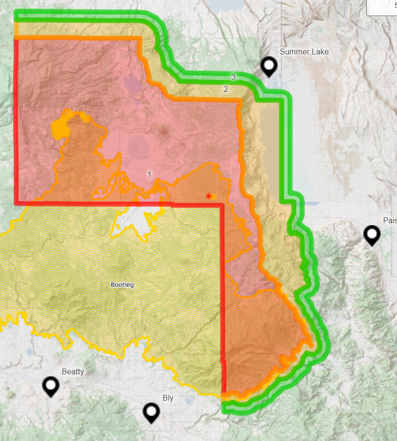
Lakeview, OR – Evacuations. Evacuation levels for the Bootleg Fire are being lowered again in Lake County. Thanks both to some helpful weather and firefighters’ containment efforts, the Lake County Sheriff’s Office and Emergency Management are removing all residences in Lake County outside of the fire’s perimeter from a Level 3 evacuation. Effective immediately:
Level 3 – GO NOW!
A Level 3 evacuation remains in place for all areas inside the Bootleg Fire perimeter. The Level 3 extends to areas immediately adjacent to the fire line in all directions, and also includes Yamsay Mountain, Thompson Reservoir, and the Sycan Marsh to the top of Winter Rim.
Level 2 – Be Set
A Level 2 evacuation is in place adjacent to the Level 3 evacuation area in all directions, and encompasses Highway 31 from milepost 73 south to Monument Rock.
Level 1 – Be Ready
A Level 1 evacuation is in place adjacent to the Level 2 evacuation area in all directions. The communities of Summer Lake and Paisley are in no evacuation level.
Please use the link to the interactive map below to view these current evacuation levels.
Despite lowered evacuation levels, Lake County must remain vigilant to hazards presented by the Bootleg Fire. The fire is still actively burning in many areas and firefighters and equipment are traveling and accessing the fire from Lake County roads and highways. Further, the Fremont-Winema Forest remains closed; see updated closure orders on the Fremont-Winema website under ‘Alerts and Notices’.
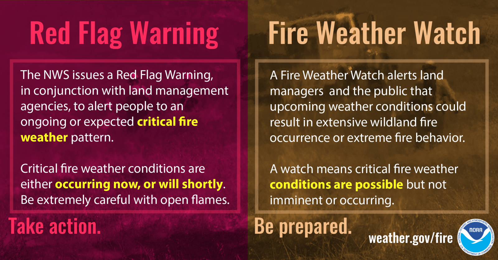
Fire Information. Red Flag Warnings and Fire Weather Watches are in effect in parts of Lake County over the next several days. This means current fires may become more active and new fire starts may occur.
Find the latest fire information, which is published by the Bootleg Fire Incident Management Team, via the links below.
Bootleg Interactive Evacuation Map: https://kcgis.maps.arcgis.com/apps/webappviewer/index.html?id=4bfb02b41eb7473ca95b04c3cbd1da21
Inciweb Incident Information System: https://inciweb.nwcg.gov/incident/7609/
Facebook Page: https://www.facebook.com/BootlegFireInfo
Lake County Website/Facebook Page: https://www.lakecountyor.org/index.php and https://www.facebook.com/Lake-County-Oregon-104435824529906
FIRE WEATHER WATCH ISSUED
Related Incident:
Publication Type: Announcement
FIRE WEATHER WATCH ISSUED FOR THE KLAMATH BASIN AND FREMONT-WINEMA NATIONAL FOREST BY THE NATIONAL WEATHER SERVICE
FIRE WEATHER WATCH IN EFFECT FROM FRIDAY AFTERNOON THROUGH FRIDAY EVENING (7/30/2021) FOR ABUNDANT LIGHTNING ON DRY FUELS
* Impacts: Lightning over dry vegetation will likely result in new fire starts. Gusty thunderstorm winds could contribute to fire spread. Despite rainfall with storms, initial attack resources could be overwhelmed and holdover fires are possible.
* Affected area: On Friday, the Fire Weather Watch includes Klamath and western Lake County which is Zone 624, which includes the Bootleg Fire (link to NWS Zone 624 https://tinyurl.com/4z5c7dhb)
* Wind: Southwest 5-10 mph with gusts to 15 mph, except for strong shifting winds near thunderstorms.
THE NATIONAL WEATHER SERVICE IN MEDFORD HAS ISSUED A FIRE WEATHER WATCH WHICH IS IN EFFECT FROM FRIDAY AFTERNOON THROUGH FRIDAY EVENING.

Bootleg Fire Daily Update July 29
Related Incident:
Publication Type: News
Bootleg Update July 29, 2021
Location: 28 miles northeast of Klamath Falls, OR Size: 413,545 acres
Personnel: 1,994 Containment: 53%
(Klamath Falls, OR) – Despite the recent rain, fire activity picked up yesterday. Fire Behavior Specialist Chris Moore commented on how unusual it is to see fire flare ups so quickly after a wetting rain. “As we move out of normal climatological range, previous experience is less relevant,” said Moore. “The rain that we got will not put the fire out. Spotting will become more of an issue as fuels dry out again.” Incident Commander Norm McDonald reinforced this caution stating that we need “a recalibration of where we are. There isn’t a ‘normal’ anymore. We need to be prepared for anything.”
Fire activity increased as the warm day dried out the fire faster and wind gusts were stronger than expected. The northwest corner remains the most active area. Dozers and hand crews are working together to close the line around that portion of the perimeter. Heavy helicopter support kept the fire cool while crews worked around Round Butte. The objective today is to hold and secure the progress made.
Two more ember-cast spot fires were identified yesterday off the northeast flank of the fire, west of Winter Rim. The spot fires were about a half mile outside the fire perimeter and small in size (less than two acres). Helicopters dropped water as air tankers made multiple retardant drops. It still requires firefighters working on the line to secure these spots. Crews will continue to take aggressive action to address any future spot fires.
The east flank of the fire remains active. That edge of the fire is a “dirty edge,” that is, there isn’t a continuous edge to the fire in this area as the fire leaves pockets of unburned vegetation. This ragged edge is more difficult for crews to secure.
In the southern portion of the fire, where activity has been relatively quiet, there were flare ups and smoke plumes visible yesterday from inside the burned area. This is a good thing. Burning fuels within the fire perimeter will help decrease the heat and chances for ember cast in the future.
Warm weather will continue through the week. Gusty winds are expected today, especially in more open areas. Yesterday a Fire Weather Watch was issued for much of the fire area through Friday. West of the fire, a Red Flag Warning is in effect through tomorrow due to thunderstorms. Scattered rain and isolated thunderstorms are possible through the weekend. More information available at https://inciweb.nwcg.gov/incident/article/7609/62198/
Evacuations: Evacuations are dynamic. Klamath County has dropped all evacuation notices; however, the Fremont-Winema National Forest remains closed. Evacuation levels are being lowered again in Lake County. The Lake County Sheriff’s Office and Emergency Management are removing all residences in Lake County outside of the fire’s perimeter from a Level 3 evacuation. Effective immediately. The best way to view the evacuation designation boundaries and details is on the interactive map available at tinyurl.com/bootlegevac
Red Cross Evacuation Shelters: For information or assistance: 1-800-Red-Cross (www.redcrossblog.org/disaster)
Insurance Assistance: For additional information on submitting insurance claims after losing your home or property to a wildfire, please visit https://dfr.oregon.gov/insure/home/storm/Pages/wildfires.aspx or call the state’s team of consumer advocates at 888-877-4894 (toll-free).
Closures: The Fremont-Winema National Forest is closed to the public in the fire area. The full closure order and map are available at https://www.fs.usda.gov/alerts/fremont-winema/alerts-notices
Smoke: Winds out of the southwest could blow smoke over the eastern parts of the region. The communities of Silver Lake and Paisley could see elevated air quality today. There is a chance that Silver Lake could see some of the heaviest impacts. See: fires.airfire.org/outlooks/southcentraloregon
Fire Information Public Phone: 541-482-1331 Fire Information Media Phone: 971-727-7255
Inciweb: inciweb.nwcg.gov/incident/7609/ Facebook: www.facebook.com/BootlegFireInfo
Twitter: twitter.com/BootlegFireInfo Hashtags: #BootlegFire #FireYear2021
Actualizacion del Incendio de Bootleg Julio 29 2021
Related Incident:
Publication Type: News
Actualizacion del Incendio de Bootleg Julio 29, 2021
Localización: 28 millas noreste de Klamath Falls, OR Tamaño: 413,545 acres
Personal: 1,994 Contención: 53%
(Klamath Falls, OR) – - Ayer, a pesar de la lluvia reciente, la actividad del incendio aumentó. El especialista en comportamiento de fuegos, Chris Moore, comentó lo inusual que es ver llamaradas tan rápido después de una lluvia que mojo el terreno. "A medida que nos movemos fuera del rango climatológico normal, la experiencia previa es menos relevante", dijo Moore. “La lluvia que recibimos no apagará el incendio. Focos secundarios se convertirá en un problema mayor a medida que los combustibles se sequen nuevamente ". El comandante de incidentes Norm McDonald reforzó esta advertencia al afirmar que necesitamos “una recalibración de dónde estamos. Ya no hay nada "normal". Necesitamos estar preparados para cualquier cosa ".
La actividad del incendio se incrementó debido a ráfagas de vientos más intensas que lo esperado y un día lo cual que secó con rapidez el incendio. La esquina noroeste sigue siendo el área más activa. Las dozers y las cuadrillas con herramientas manuales están trabajando juntos para cerrar la línea alrededor de esa parte del perímetro. El apoyo de helicóptero ayudo a controlar el fuego mientras los equipos trabajaban alrededor de Round Butte. El objetivo hoy es mantener y asegurar los progresos realizados.
Ayer se identificaron dos focos secundarios causados por brasas en el flanco noreste del incendio, al oeste de Winter Rim. Los focos secundarios se encontraban aproximadamente a media milla fuera del perímetro del incendio con un área pequeña (menos de dos acres). Los helicópteros descargaron agua mientras los aviones cisterna realizaban múltiples descargas de retardantes de fuego. Todavía se requiere que los bomberos trabajen en la línea para asegurar estos lugares. Las cuadrillas continuarán tomando medidas agresivas para combatir cualesquier focos secundarios en el futuro.
El flanco este del fuego permanece activo. Ese borde del fuego es un "borde sucio", es decir, no hay un borde continuo con el incendio en esta área, ya que el fuego deja focos de vegetación sin quemar. Este borde irregular es más difícil de asegurar para las cuadrillas.
En la parte sur del incendio, donde la actividad ha sido relativamente tranquila, ayer hubo llamaradas y columnas de humo visibles desde el interior del área quemada. Esto es una cosa buena. La quema de combustibles dentro del perímetro del fuego ayudará a disminuir el calor y las posibilidades de que se formen lanzamientos de brasas en el futuro.
El clima cálido continuará durante la semana. Se esperan ráfagas de vientos hoy, especialmente en áreas más abiertas. Ayer se pronunció una alerta meteorológica de incendios para gran parte del área del incendio hasta el viernes. Al oeste del incendio, una Advertencia de Bandera Roja estará presente hasta mañana debido a tormentas eléctricas. Es posible que haya lluvias dispersas y tormentas eléctricas aisladas durante el fin de semana. Más información disponible en https://inciweb.nwcg.gov/incident/article/7609/62198/
Evacuaciones: Evacuaciones son dinámicas. El condado de Klamath ha terminado todos los avisos de evacuación; sin embargo, el Bosque Nacional Fremont-Winema permanece cerrado. Los niveles de evacuación se han reducidos nuevamente en el condado de Lake. La Oficina del Sheriff del Condado de Lake y el Manejo de Emergencias están removiendo todas las residencias en el Condado de Lake fuera del perímetro del incendio para una evacuación de Nivel 3. Efectivo inmediatamente. La forma más eficaz de ver las áreas y bordes de las nuevas designaciones de evacuaciones es en el mapa interactivo disponible en tinyurl.com/bootlegevac.
Refugios de evacuación de la Cruz Roja: Para obtener información o asistencia: 1-800-Red-Cross, (www.redcrossblog.org/disaster).
Asistencia de seguros: Para obtener información adicional sobre cómo presentar reclamaciones de seguros después de perder su casa o propiedad en un incendio forestal, visite https://dfr.oregon.gov/insure/home/storm/Pages/wildfires.aspx o llame al equipo de defensores estatal del consumidor al 888-877-4894 (llamada gratuita).
Cierres: El Bosque Nacional Fremont-Winema está cerrado al público en el área del incendio. El mapa y la orden completa están disponibles en inciweb.nwcg.gov/incident/7609/.
Pronostico del humo: Los vientos del suroeste podrían desviar el humo hacia la parte oeste de la región. Hoy, las comunidades de Silver Lake y Paisley podrían experimentar un empeoramiento en la calidad del aire. Existe la posibilidad de que Silver Lake pueda ver algunos de los impactos más fuertes. Visite: fires.airfire.org/outlooks/southcentraloregon.
Información sobre el incendio para el público: 541-482-1331 Información del incendio para la media: 971-727-7255
Inciweb: inciweb.nwcg.gov/incident/7609/ Facebook: www.facebook.com/BootlegFireInfo
Twitter: twitter.com/BootlegFireInfo Hashtags: #BootlegFire #FireYear2021
Virtual Community Meeting on July 30 2021 at 630 pm
Related Incident:
Publication Type: Announcement
Join us for a Virtual Bootleg Fire Community Meeting at 6:30 pm on July 30, 2021. A remote broadcast of the virtual meeting will be available at City Hall in Paisley, 705 Chewaucan St., Paisley, OR 97636. Incident Management Team Members will give an update and answer questions about the Bootleg Fire.
National Weather Service has Issued a Red Flag Warning
Related Incident:
Publication Type: Announcement
The National Weather Service in Medford has Issued a Red Flag Warning, which is in effect from 2pm to 11pm PDT Friday. The Fire Weather watch is No Longer in Effect.
* Impacts: Lightning and Dry Vegetation will Likely Result in New Fire Starts. Gusty thunderstorm winds Could Contribute to Fire Spread. Despite Rainfall, Initial Attack Resources Could Be Overwhelmed and Holdover Fires are Possible.
* Affected Area: South Central or the Southwestern Half and Southeast Corner Of Fire Zone 625. This includes the Bootleg Fire.
* Wind: Northwest 5 to 10 MPH with Gusts to 15 MPH, Except Gusty, Shifting winds are Likely near Thunderstorms.
* View the Hazard area in Detail At: https://www.wrh.noaa.gov/mfr/hazard
Gather your Fire Evacuation Kit Now. Collect Essentials you Don't Want to Lose and Prioritize your Checklist. Visit Ready.gov/kit for More Information.
Familiarize Yourself with your Evacuation Plan. Where will you Go? How will you Get There? Who will you Call to Let Others Know Your are Safe? Visit Ready.gov/wildfires for More Information.
A Red Flag Warning Does Not Mean There is a Fire. It Means That Critical Fire Weather Conditions are Either Occurring Now or Will
Shortly. These Conditions Promote Rapid Spread of Fire Which May Become Life Threatening. Evacuate if Ordered to, or if a Fire
Threatens.