
Incident Publication
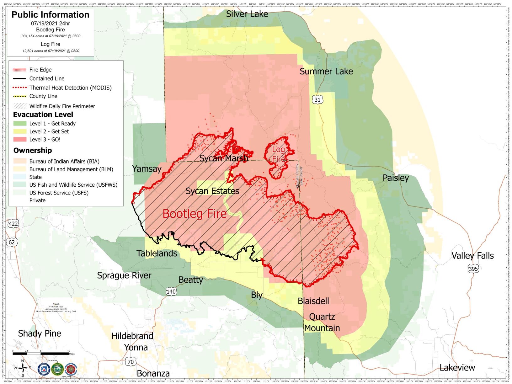
Updated Bootleg Fire Map July 19
Related Incident:
Publication Type: News
Overnight the Bootleg Fire saw a significant increase in activity and acres burned. The predicted high winds and low humidity associated with the Red Flag Warning contributed to the increase in fire activity. Due to mechanical issues, the Infrared (IR) Flight was not completed but fire managers and geographic information system specialist have worked to ground truth firefighter inputs and satellite data to produce an updated perimeter for the fire. The new acreage is estimated at 343,755 and containment remains at 25%.
Red Flag Warnings for high winds and low humidity are in place again for Monday, July 19th and the potential to experience another day of large fire growth is possible.
IR Flights are one of several data tools used to build map products for wildland fire incidents. Aircraft are equipped with thermal sensors and used to detect heat signatures and support developing incident perimeters. Other data sources that support the development of these mapping products include satellite data and ground resources providing data points.
See links below for map image or PDF.
Lake County Evacuation Update
Related Incident:
Publication Type: Announcement
Lake County Sheriff’s Office Media Release
July 19, 2021, 4:30 p.m.
Contact: Melanie Lasley (541) 947-6003
mlasley@co.lake.or.us
For Immediate Release
Lakeview, OR – Evacuations. Additional evacuation levels have been implemented in Lake County due to increased activity on the Bootleg and Log Fires. Lake County utilized its emergency alert system to notify residents in the affected areas by Wireless Emergency Alert, text, email, and phone. Law enforcement agencies are also attempting to reach all affected residents, door-to-door.
Level 3 – GO NOW! From Mile Post 73 on Highway 31 south along Winter Ridge to Government Harvey Pass, then east to the Highway 31 and Government Harvey junction, then back north to include both sides of Highway 31. This area is south of the community of Summer Lake.
Level 2 – Be Set From Picture Rock Pass south along Winter Ridge to Mile Post 73 and east of the middle of Summer Lake to Government Harvey Pass, then east of Slide Lake Trailhead to west of the Red House Road junction with Highway 31, then back north including Summer Lake Flats and the Ana Subdivision.
These evacuations extend and/or change the currently implemented levels. The most effective method for viewing current evacuation levels is by using the link to the interactive map below. Evacuation maps are also posted in and shared with community gathering places throughout the fire evacuation areas by incident management team staff.
Highway closures may occur; residents should review road closures at ODOT’s tripcheck.com.
Remember that:
• Level 1 evacuation means “BE READY” for potential evacuation. Be aware of danger in your area and monitor emergency services websites and media outlets for information. Prepare yourself and belongings for evacuation and consider movement of persons with special needs, mobile property and pets and livestock.
• Level 2 evacuation means “BE SET” to evacuate. Be ready to leave at a moment’s notice; there is a significant danger to your area. Residents may voluntarily relocate to a shelter or with family/friends outside the affected area. You may have time to gather necessary items, but doing so is at your own risk.
• Level 3 evacuation means “GO NOW” – leave immediately! Danger is current or imminent. If you choose to ignore this advisement, understand that emergency services may not be able to assist you further. DO NOT delay to gather belongings or make efforts to protect your home.
Again, evacuation shelters are located at the following locations: the Daly Middle School Auditorium (220 South H St.) in Lakeview, the Klamath County Fairgrounds in Klamath Falls, and La Pine Middle School.
Fire Information. Find the latest fire information, which is published by the Bootleg Fire Incident Management Team, via the links below. EMERGENCY INFORMATION
Fire Information Public Phone: 541-482-1331
Bootleg Interactive Evacuation Map: https://kcgis.maps.arcgis.com/apps/webappviewer/index.html?id=4bfb02b41eb7473ca95b04c3cbd1da21
Inciweb Incident Information System: https://inciweb.nwcg.gov/incident/7609/
Facebook Page: https://www.facebook.com/BootlegFireInfo
Lake County Website/Facebook Page: https://www.lakecountyor.org/index.php and https://www.facebook.com/Lake-County- Oregon-104435824529906
###
Bootleg Fire Daily Update July 20
Related Incident:
Publication Type: News
Location: 28 miles northeast of Klamath Falls, OR
Size: 388,359 acres
Personnel: 2,250
Containment: 30%
(Klamath Falls, OR) – For ten days in a row, extreme fire behavior in the afternoon and evening has resulted in firefighters moving to safety zones. Yesterday evening, parts of the fire received a trace amount of rain from thunderstorms in the area. The main Bootleg Fire merged with the Log Fire as anticipated. Fire activity in this area was moderated by smoke cover decreasing fire intensity, so firefighters took advantage of conditions to improve the northeastern firelines. Toward the east, significant fire movement resulted in the fire spotting over Forest Road 28 (Trunk Road) toward Summer Lake. On the north edge, firefighters made progress constructing dozer line during the night and early morning while temperatures were cooler and winds calmer. By the afternoon, with increasing winds and temperature, the fire moved across Coyote Creek and refocused on protecting the Sycan Marsh Nature Conservancy structures. Night operations were able to construct dozer line to Long Creek and establish an anchor point near Nature Conservancy structures.
Firefighters continue to patrol 40+ miles of fireline on the southern and western flanks of the fire. There continues to be areas of heat in several locations on the west and south of the fire including the Preacher Flats area. As crews patrol, they look for places to mitigate risks to the controlled line of the fire. Property owners are reminded to use caution when returning; hazardous hot spots and fire-weakened trees remain throughout the area. Please use an abundance of caution around these areas. Additionally, unburned fuels within the fire perimeter will continue to burn and produce smoke for weeks.
“Fighting this fire is a marathon, not a sprint,” said Rob Allen, Incident Commander for PNW Incident Management Team 2. “We’re in this for as long as it takes to safely confine this monster”.
Today, winds will be from the southwest with a Red Flag Warning from 2 to 8 p.m. for gusty winds and low relative humidity, resulting in continued movement of the fire toward the east. Today, firefighters will work to mitigate risks for by aggressively felling hazard trees. Crews will continue to work on areas where the fire has slopped or spotted over Forest Roads 28 and 34. If they are not successful in the next 24 hours, they will fall back to structure protection in the Summer Lake community, with possible Hwy 31 closure and a burn out operation to remove fuels between the residential areas and the main fire. In the north toward Silver Lake, firefighters plan to close the gap of fireline between Long Creek and the anchor point at Nature Conservancy structures. Firefighters are preparing secondary fireline and scouting for contingency firelines in all areas of fire growth. Structural protection firefighting crews continue to progress and work to mitigate risks to structures. As crews move around the evolving fire, resources are shifted to more active areas of the fire.
Community Meeting: July 20, 2021 at 6:30pm Facebook Live @BootlegFireInfo. The meeting will be live streamed and a recording posted to https://www.facebook.com/bootlegfireinfo
Evacuations: Evacuations are rapidly changing due to the nature of this wildfire. Interactive map of evacuation levels in Lake and Klamath Counties at tinyurl.com/bootlegevac Red Cross Evacuation Shelters: Open 24/7 New Site: Thrive Church - 235 South Laguna St. Klamath Falls, Oregon and Daly Middle School 906 S 3rd St. Lakeview, Oregon for information or assistance: 1-800-Red-Cross, FB @RedCrossCascades , (www.redcrossblog.org/disaster)
Closures: The Fremont-Winema National Forest is closed to the public in the fire area. Map and full order available at inciweb.nwcg.gov/incident/7609/.
Smoke: Smoke impacts will be high in areas north, northeast, and east of the fire, especially in the vicinity of Silver Lake, Summer Lake, and Paisley. See: fires.airfire.org/outlooks/southcentraloregon.
Fire Information Public Phone: 541-482-1331
Fire Information Media Phone: 971-727-7255
Inciweb: inciweb.nwcg.gov/incident/7609/
Facebook: www.facebook.com/BootlegFireInfo
Twitter: twitter.com/BootlegFireInfo
Hashtags: #BootlegFire #FireYear2021
Actualizacion del Incendio de Bootleg Julio 20
Related Incident:
Publication Type: News
Localización: 28 millas noreste de Klamath Falls, OR Tamaño: 388,359 acres
Personal: 2,250 Contención: 30%
(Klamath Falls, OR) – Durante diez días seguidos, el comportamiento extremo del fuego por la tarde y la noche provoco que los bomberos se trasladen a zonas de seguridad. Ayer por la noche, partes del incendio recibieron una pequeña cantidad de lluvia de las tormentas eléctricas en el área. El incendio principal de Bootleg se unió con el incendio Log como se anticipaba. La actividad del fuego en esta área fue moderada por la cobertura de humo que disminuyó la intensidad del fuego, por lo que los bomberos aprovecharon las condiciones para mejorar las líneas de fuego del noreste. Hacia el este, un movimiento de fuego significativo dio como resultado que el incendio se viera sobre Forest Road 28 (Trunk Road) hacia Summer Lake. En el extremo norte, los bomberos avanzaron en la construcción de la línea de bulldozers durante la noche y la madrugada, mientras que las temperaturas eran más frescas y los vientos más ligeros. Por la tarde, con el aumento de los vientos y la temperatura, el fuego se movió a través de Coyote Creek y los bomberos se volvieron a enfocar en proteger las estructuras de Sycan Marsh Nature Conservancy. Las operaciones nocturnas pudieron construir una línea de bulldozer hasta Long Creek y establecer un punto de anclaje cerca de las estructuras de Nature Conservancy.
Los bomberos continúan patrullando más de 40 millas de línea de fuego en los flancos sur y oeste del incendio. Continúa habiendo áreas hipertérmicas en varios lugares al oeste y al sur del incendio, incluida el área de Preacher Flats. Mientras las cuadrillas patrullan, buscan lugares para mitigar los riesgos a la línea de contención del fuego. Un recordatorio a los propietarios, tengan cuidado al regresar al área; son peligrosos los puntos calientes y los árboles debilitados por el fuego permanecen en toda el área. Tenga mucho cuidado en estas áreas. Además, los combustibles forestales que no se han quemados dentro del perímetro del incendio continuarán ardiendo y produciendo humo durante las próximas semanas.
“Combatir este incendio es un maratón, no un sprint”, dijo Rob Allen, Comandante de Incidentes del PNW Incident Management Team 2. “Estaremos en esto todo el tiempo que sea necesario para confinar de manera segura a este monstruo”.
Hoy, los vientos serán del suroeste con una Advertencia de Bandera Roja de 2 a 8 p.m. por las ráfagas de vientos y baja humedad relativa, lo que resulta en un movimiento continuo del fuego hacia el este. Hoy, los bomberos trabajarán para mitigar los riesgos mediante la tala agresiva de árboles peligrosos. Las cuadrillas continuarán trabajando en áreas donde el incendio se ha sobrepasado o causado focos secundarios sobre los caminos forestales 28 y 34. Si no tienen éxito en las próximas 24 horas, recurrirán a la protección de las estructuras en la comunidad de Summer Lake, con el posible cierre de la Hwy 31 y una operación de quema de ensanche para remover combustibles entre las áreas residenciales y el incendio principal. En el norte hacia Silver Lake, los bomberos planean cerrar la brecha de la línea del incendio entre Long Creek y el punto de anclaje en las estructuras de Nature Conservancy. Los bomberos están preparando una línea de fuego secundaria y explorando líneas de contingencia en todas las áreas de crecimiento del fuego. Los equipos de contraincendios de protección estructural continúan avanzando y trabajando para mitigar los riesgos de las estructuras. A medida que las cuadrillas se mueven alrededor del fuego en evolución, los recursos se trasladaran a áreas más activas del fuego.
Reunión comunitaria: 20 de julio de 2021 a las 6:30 pm en Facebook Live @BootlegFireInfo. La reunión se transmitirá en vivo y se publicará una grabación en https://www.facebook.com/bootlegfireinfo
Evacuaciones: Las evacuaciones están cambiando rápidamente debido al comportamiento de este incendio forestal. Visite tinyurl.com/bootlegevac para obtener un mapa interactivo de los niveles de evacuación en los condados de Lake y Klamath. Refugios de evacuación de la Cruz Roja: están abiertos las 24 horas, los 7 días de la semana: Nueva localización: Thrive Church – 235 South Laguna St Klamath Falls, Oregon y Daly Middle School 906 S 3rd St. Lakeview, Oregon para obtener información o asistencia: 1-800-Red-Cross y FB @RedCrossCascades
Cierres: El Bosque Nacional Fremont-Winema está cerrado al público en el área del incendio. Mapa y la orden completa están disponibles en inciweb.nwcg.gov/incident/7609/.
Pronostico del humo: Los impactos del humo continuarán siendo altos en las áreas al norte, noreste y este del incendio especialmente en las cercanías de Silver Lake, Summer Lake y Paisley. Visite: fires.airfire.org/outlooks/southcentraloregon.
Información sobre el incendio para el público: 541-482-1331
Información del incendio para la media: 971-727-7255
Inciweb: inciweb.nwcg.gov/incident/7609/
Facebook: www.facebook.com/BootlegFireInfo
Twitter: twitter.com/BootlegFireInfo
Hashtags: #BootlegFire #FireYear2021
Lakeview Community Meeting July 21 2021 700 pm
Related Incident:
Publication Type: Announcement
There will be a community meeting in Lakeview at 7:00 p.m. on July 21, 2021. Incident management personnel will give an update on the fire, and to answer questions. The meeting will be at the Alger Community Theater.
Bootleg Fire Daily Update July 21
Related Incident:
Publication Type: News
Location: 28 miles northeast of Klamath Falls, OR Size: 394,407 acres
Personnel: 2,268 Containment: 32%
(Klamath Falls, OR) – The weather moderated yesterday with reduced wind speeds, lower temperatures, and slightly higher humidity, which allowed firefighters to continue constructing and improving firelines. Weather conditions are favorable again today for the efforts to secure existing fireline.
On the northern edge of the fire, line was constructed to Long Creek and firefighters scouted a line to tie into the anchor point near the Sycan Marsh Nature Conservancy. The reduced fire activity yesterday allowed firefighters to construct dozer line directly against the fire edge along the north and east boundary of the Log Fire. There is expected northeast movement of the fire toward Winter Ridge and Summer Lake. Crews and equipment are going direct while also working to improve contingency lines between the fire and those communities and provide structure protection for those homes.
Firefighters are continuing to work around the southeastern corner of the fire where the majority of recent growth has occurred. As the fire pushes up into the old Watson Fire burn area, fuels become less continuous and fire behavior is decreased. Crews are challenged by working around many snags in this area but are making good progress. Any fire that spots over or pushes the fire line has the potential for additional rapid growth.
Firefighters continue to patrol the fireline along the southern to northwestern flanks of the fire. As crews patrol, they look for places to mitigate risks to the controlled line of the fire. Returning residents to these areas may see unburned fuels within the fire perimeter that will continue to burn and produce smoke for weeks.
The Oregon State Fire Marshal’s Office’s (OSFM) Green Team is demobilizing today after working at the fire for two weeks. Yesterday, they worked to support the transition of the incoming Red Team which will continue the OSFM’s mission of protecting lives and homes. The OSFM’s team is working in Unified Command with the two other incident management teams on the Bootleg Fire.
“While our Incident Management Team may be transitioning, our dedication to protecting the community remains. Our firefighters are up to the task, their work the last two weeks has undoubtedly protected hundreds of homes and we remain vigilant to the task at hand.” Ian Yocum, Oregon State Fire Marshal’s Red Team Incident Commander.
Community Meeting – Members of the team will meet with the community tonight, July 21, 2021, at 7:00 p.m. at the Alger Community Theatre (24 South F Street, Lakeview, OR 97630).
Evacuations: Evacuations are rapidly changing due to the nature of this wildfire. Interactive map of evacuation levels in Lake and Klamath Counties at tinyurl.com/bootlegevac
Red Cross Evacuation Shelters: Open 24/7 New Site: Thrive Church - 235 South Laguna St. Klamath Falls, Oregon and Daly Middle School 906 S 3rd St. Lakeview, Oregon for information or assistance: 1-800-Red-Cross, FB @RedCrossCascades, (www.redcrossblog.org/disaster)
Closures: The Fremont-Winema National Forest is closed to the public in the fire area. Map and full order available at inciweb.nwcg.gov/incident/7609/.
Smoke: Smoke impacts will be high in areas north, northeast, and east of the fire, especially in the vicinity of Silver Lake, Summer Lake, and Paisley. See: fires.airfire.org/outlooks/southcentraloregon.
Fire Information Public Phone: 541-482-1331 Fire Information Media Phone: 971-727-7255
Inciweb: inciweb.nwcg.gov/incident/7609/ Facebook: www.facebook.com/BootlegFireInfo
Twitter: twitter.com/BootlegFireInfo Hashtags: #BootlegFire #FireYear2021
Actualizacion del Incendio de Bootleg Julio 21
Related Incident:
Publication Type: News
Localización: 28 millas noreste de Klamath Falls, OR Tamaño: 394,407 acres
Personal: 2,268 Contención: 32%
(Klamath Falls, OR) – El clima mejoró ayer con reducción en la velocidad de los vientos y temperatura, y humedad ligeramente más alta, lo que permitió a los bomberos continuar construyendo y mejorando las líneas de fuego. Las condiciones climáticas son favorables nuevamente hoy para los esfuerzos de asegurar la línea de fuego existente.
En el borde norte del incendio, se construyó una línea hasta Long Creek y los bomberos buscaron para atarla al punto de anclaje cerca de Sycan Marsh Nature Conservancy. La actividad de fuego reducida ayer permitió a los bomberos construir una línea de bulldozer directamente contra el borde del fuego a lo largo del límite norte y este del incendio de Log. Se espera un movimiento noreste del fuego hacia Winter Ridge y Summer Lake. Las cuadrillas y el equipo van en rumbo con el movimiento del fuego mientras trabajan para mejorar las líneas de contingencia entre el incendio y esas comunidades y ofrecer protección estructural para esas casas.
Los bomberos continúan trabajando en la esquina sureste del incendio, donde recientemente ha ocurrido la mayor parte del crecimiento. A medida que el fuego avanza hacia la antigua zona de quema del incendio de Watson, los combustibles se vuelven menos continuos y el comportamiento del fuego disminuye. Las cuadrillas enfrentan el desafío de trabajar en torno a muchos obstáculos como troncos quemados en esta área, pero están logrando un buen progreso. Cualquier incendio que sobrepase o cause puntos secundarios en la línea de fuego tiene el potencial de un crecimiento rápido adicional.
Los bomberos continúan patrullando la línea de fuego a lo largo de los flancos del sur al noroeste del fuego. Mientras las cuadrillas, buscan lugares para mitigar los riesgos a la línea controlada del fuego. Los residentes que regresan a estas áreas pueden ver combustibles sin quemar dentro del perímetro del incendio que continuarán ardiendo y produciendo humo durante semanas.
El Oregon State Fire Marshal’s Office’s (OSFM) Equipo Verde se está desmovilizando hoy después de trabajar en el incendio durante dos semanas. Ayer, trabajaron para apoyar la transición del Equipo Rojo entrante que continuará la misión de OSFM de proteger vidas y hogares. El equipo de OSFM está trabajando en Comando Unificado con los otros dos equipos de gestión de incidentes en el Incendio de Bootleg.
“Aunque nuestro equipo de gestión de incidentes está en transición, nuestra dedicación a proteger a la comunidad permanece. Nuestros bomberos son capaces de completar la meta, su trabajo de las últimas dos semanas sin duda ha protegido cientos de hogares y nos mantenemos atentos a la tarea que tenemos a mano”. Ian Yocum, Comandante de Incidentes del Equipo Rojo del Oregon State Fire Marshal’s Office.
Reunión comunitaria: Los miembros del equipo se reunirán con la comunidad esta noche, 21 de julio de 2021, a las 7:00 p.m. en el Teatro Comunitario de Alger (24 South F Street, Lakeview, OR 97630).
Evacuaciones: Refugios de evacuación de la Cruz Roja: están abiertos las 24 horas, los 7 días de la semana: Nueva localización: Thrive Church – 235 South Laguna St Klamath Falls, Oregon y Daly Middle School 906 S 3rd St. Lakeview, Oregon para obtener información o asistencia: 1-800-Red-Cross, FB @RedCrossCascades y (www.redcrossblog.org/disaster).
Cierres: El Bosque Nacional Fremont-Winema está cerrado al público en el área del incendio. Mapa y la orden completa están disponibles en inciweb.nwcg.gov/incident/7609/.
Pronostico del humo: Los impactos del humo continuarán siendo altos en las áreas al norte, noreste y este del incendio especialmente en las cercanías de Silver Lake, Summer Lake y Paisley. Visite: fires.airfire.org/outlooks/southcentraloregon.
Información sobre el incendio para el público: 541-482-1331 Información del incendio para la media: 971-727-7255
Inciweb: inciweb.nwcg.gov/incident/7609/ Facebook: www.facebook.com/BootlegFireInfo
Twitter: twitter.com/BootlegFireInfo Hashtags: #BootlegFire #FireYear2021
Emergency Notification Evacuation Decreases in Lake County
Related Incident:
Publication Type: Announcement
Lake County Sheriff's Office Media Release
July 21, 2021, 2:00 p.m.
Lakeview, OR – Evacuations. Evacuation level boundaries are being decreased in Lake County for the Bootleg Fire due to increased fire containment in Quartz Mountain area. The other evacuation levels will remain the same until further notice. Lake County utilized its alerting system to notify residents in the affected areas.
This evacuation notice only applies to the Quartz Mountain area from the FS 34 Road near Mitchell Monument to Highway 140 East.
Level 3 – GO NOW!
From 1 mile from Sprague River on the county line, east to Bear Flat, continuing to Dairy Point.
Level 2 – Be Set
From one mile south of the South Fork Sprague River, on the county line, south to Owen Butte, east to Quartz Valley Mountain, northeast to upper Coleman Rim.
Level 1 – Be Ready
From lower Coleman Rim north Highway 31, north to Owen Butte, east to Quartz Valley to the FS 28 Road.
These evacuations extend and/or change the currently implemented levels. The most effective method for viewing current evacuation levels is by using the link to the interactive map below.
Evacuation maps are also posted in and shared with community gathering places throughout the fire evacuation areas by incident management team staff. Remember that:
· Level 1 evacuation means “BE READY” for potential evacuation. Be aware of danger in your area and monitor emergency services websites and media outlets for information. Prepare yourself and belongings for evacuation and consider movement of persons with special needs, mobile property and pets and livestock.
· Level 2 evacuation means “BE SET” to evacuate. Be ready to leave at a moment’s notice; there is a significant danger to your area. Residents may voluntarily relocate to a shelter or with family/friends outside the affected area. You may have time to gather necessary items, but doing so is at your own risk.
· Level 3 evacuation means “GO NOW” – leave immediately! Danger is current or imminent. If you choose to ignore this advisement, understand that emergency services may not be able to assist you further. DO NOT delay to gather belongings or make efforts to protect your home.
Evacuation shelters are located at the following locations: The Thrive Church (235 S Laguna St.) in Klamath Falls, and La Pine Middle School (16360 S 1st St.).
Fire Information. Find the latest fire information, which is published by the Bootleg Fire Incident Management Team, via the links below.
Fire Information Public Phone: 541-482-1331
Bootleg Interactive Evacuation Map:
https://kcgis.maps.arcgis.com/apps/webappviewer/index.html?id=4bfb02b41eb7473ca95b04c3cbd1da21
Inciweb Incident Information System: https://inciweb.nwcg.gov/incident/7609/
Facebook Page: https://www.facebook.com/BootlegFireInfo
Lake County Website/Facebook Page: https://www.lakecountyor.org/index.php and https://www.facebook.com/Lake-County-Oregon-104435824529906
###
Emergency Notification Changes in Evacuation Levels for Klamath County
Related Incident:
Publication Type: Announcement
The following changes in the evacuation levels for Klamath County are for immediate release:
Previously Level 1 areas south of Highway 140 from the lake county line extending west, have been removed.
Previously Level 2 areas south of the fire perimeter and west of Ivory Pine Rd including the upper tablelands and Oregon Pines areas have been reduced to Level 1 (BE READY) evacuation notice.
All other evacuation levels remain in place at this time.
Residents returning to fire damaged areas are urged to exercise extreme caution as hazards such as damaged trees remain. In addition roads in the fire damaged areas are open only to residents and emergency crews only.
Brandon Fowler
Klamath County Emergency Manager
Bootleg Fire Daily Update July 22
Related Incident:
Publication Type: News
Location: 28 miles northeast of Klamath Falls, OR
Size: 399,359 acres
Personnel: 2359 Containment: 38%
(Klamath Falls, OR) – Higher humidity and reduced wind speeds yesterday and overnight allowed firefighters to construct and improve firelines. Today’s forecast will be favorable to continue those efforts in securing the existing fireline. A steady warming and drying trend will begin today and continue into the weekend which can affect fire activity in the upcoming days.
“Fire crews and support personnel have made significant progress in containing this fire in the last few days.”said Joe Prummer, Incident Commander trainee of Pacific Northwest Incident Management Team 2. “However, we still have a long road ahead of us to ensure the safety of the surrounding communities.”
The Oregon State Fire Marshall have transitioned to working with Zone 2 on the north and northeast sections of the fire. The fireline to Long Creek was improved with dozers and helicopter drops. Firefighters scouted the area from Long Creek to Coyote Creek to develop a plan to connect the fireline to the already completed line near The Nature Conservancy compound. Fire activity picked up in the Sycan Marsh but was quickly contained by dozers. Crews and equipment are going direct along the eastern fireline while also working to improve contingency lines between the fire and the communities near Summer Lake as well as provide structure protection for those homes. There was some slight growth to the northeast, however dozer crews were able to stop that progression and crews will work to hold that today.
In many areas of the fire, firefighters are working on patrolling and mopping areas along the line. This step is necessary to ensure that all heat that could threaten the security of the fire line has been extinguished. Resources continue to be shifted around the fire perimeter to meet resource needs across the fire area. As the need for night operations on the southern zone decreases, those resources will be moved to day shift or sent home for rest as they time out.
An additional responsibility of the firefighters on the Bootleg Fire is to provide initial attack response in the area adjacent to the fire. Any new starts have the potential to rapidly grow, given the extremely dry fuel conditions. Fire managers have identified resources that would respond immediately in the event that a new fire should start.
Evacuations: Klamath and Lake Counties have altered the evacuation zones, please make sure to check the new areas on the interactive map. Interactive map of evacuation levels in Lake and Klamath Counties at tinyurl.com/bootlegevac
Red Cross Evacuation Shelters: Open 24/7: Thrive Church - 235 South Laguna St. Klamath Falls, Oregon for information or assistance: 1-800-Red-Cross, FB @RedCrossCascades, (www.redcrossblog.org/disaster)
Closures: The Fremont-Winema National Forest is closed to the public in the fire area. Map and full order available at inciweb.nwcg.gov/incident/7609/.
Smoke: Afternoon smoke impacts will continue to be high in areas north, northeast, and east of the fire, especially in the vicinity of Silver Lake, Summer Lake, and Paisley. Continuing SW winds will push smoke from the Bootleg Fire away from Lakeview, Klamath Falls and Sprague River Valley, but may bring some smoke from the Dixie Fire into the area. See: fires.airfire.org/outlooks/southcentraloregon.
Fire Information Public Phone: 541-482-1331 Fire Information Media Phone: 971-727-7255
Inciweb: inciweb.nwcg.gov/incident/7609/ Facebook: www.facebook.com/BootlegFireInfo
Twitter: twitter.com/BootlegFireInfo Hashtags: #BootlegFire #FireYear2021