
Incident Publication
Douglas County Sherriff Office Evacuations
Related Incident:
Publication Type: Announcement
July 6, 2021 at 4:23 p.m.
Jack Creek Fire Evacuations
IDLEYLD PARK, Ore. - A LEVEL 3 EVACUATION - GO! NOTICE NOW ORDERED FOR ALL HOMES LOCATED IN THE FOLLOWING AREAS DUE TO THE JACK CREEK FIRE:
• ALL RECREATION AREAS, HOMES AND BUSINESSES LOCATED BETWEEN MILE MARKER 43 EAST TO EAGLE ROCK CAMPGROUND.
Level 3 or "GO!":
• If you chose not to evacuate, emergency services may not be able to assist you further.
• Grab your "go kit" and leave immediately.
• Follow your evacuation plan and stay informed.
Danger to the evacuated area is current and imminent and you should evacuate immediately. If you choose to ignore this advisement, you must understand that emergency services may not be available to assist you further. Do not delay leaving to gather any belongings or make efforts to protect your home. This will be the last message you receive.
LEVEL 2 "BE SET": YOU MUST PREPARE TO LEAVE AT A MOMENTS NOTICE. This level indicates there is significant danger to your area, and residents should either voluntarily relocate to a shelter or with family/friends outside of the affected area, or if choosing to remain, to be ready to evacuate at a moment's notice. Residents MAY have time to gather necessary items, but doing so is at their own risk. THIS MAY BE THE ONLY NOTICE YOU RECEIVE. Emergency services cannot guarantee that they will be able to notify you if conditions rapidly deteriorate.
• A LEVEL 2 "BE SET" NOTICE HAS BEEN ISSUED FOR EVERYTHING EAST OF EAGLE ROCK CAMPGROUND TO SODA SPRINGS.
For more information about the fire, please follow official sources of information only.
http://WWW.DCSO.COM/EVACUATIONS
JACK FIRE UPDATE JULY 7 2021 UMPQUA NATIONAL FOREST
Related Incident:
Publication Type: Announcement
ROSEBURG, OR. – JULY 7, 2021 – Firefighters are actively suppressing a wildfire near Steamboat, approximately 23 miles east of Glide, Oregon on the North Umpqua Ranger District.
The Jack Fire, which is currently estimated at 2,395 acres and 0% contained, is burning in grass and timber east of Jack Creek Road (Forest Service Road 4713) and west of Jack Creek. The Umpqua National Forest in-briefed the Northwest Incident Management Team #9 (NWIMT) and the Oregon State Fire Marshall (OSFM) Blue team the evening of July 6th.
Today, firefighters have begun using direct and indirect suppression tactics to hold the fire west of mile marker 45 on highway 138 and bound north and south by forest road 38 along Steamboat Creek and state highway 138 along the north Umpqua. The helibase was moved to the Incident Command Post established at French Creek. More favorable flight conditions are expected in the afternoon.
State highway 138 from Steamboat Creek to mile post 55 is closed to vehicle traffic. Steamboat Inn remains open and accessible from the west. Oregon Department of Transportation has set an eastside ‘soft closure’ checkpoint at Lemolo Lake junction to allow for local access into nearby recreation areas, including Lemolo Lake. Use https://tripcheck.com/ for road conditions updates.
Evacuations levels by the Douglas County Sheriff’s Office remain in effect and can be found at the following link: https://www.dcso.com/Evacuations
For the safety of the firefighters and aircraft fighting the Jack Fire, a temporary flight restriction has been placed over the fire area. Please consult the “Notice to Airman” for specifics. Wildfires are a “No Drone Zone.”
Resources currently assigned include 200 personnel: 9 engines, 7 hand crews, 3 water tenders, 3 heavy lift helicopters, 1 light helicopter, 1 dozer
Fire danger remains HIGH and public use restrictions are in effect.
Jack Fire Forest Closure Order
Related Incident:
Publication Type: News
Closure Area is described as an area starting at the confluence of the North Umpqua River and Rattlesnake Creek in T26S R2E Section I 3, then following Rattlesnake Creek to its northernmost headwaters in T25 l/2 S R2E Section 35, then Northwest to the intersection of Forest Service Road (FSR) 4760-105 and Forest Service Trail (FST) I 535, following FST I 535 Northeast to FSR 3810-360, following FSR 3810-360 Northeast to FSR 3810, following FSR 3810 Northeast to FSR 3850, following FSR 3850 North to FSR 3850-200, following FSR 3850-200 East to Bulldog Creek, following Bulldog Creek Northwest to Big Bend Creek, following Big Bend Creek Northeast to FSR 3818-030, following FSR 3818-030 West to FSR3818, following FSR 3818 Northeast to FSR 3818-100, following FSR 3818-100 North to Little Bend Creek, following Little Bend Creek Southwest to FSR 38, following FSR 38 North to FSR 3821, following FSR 3821 West to the Umpqua National Forest Boundary, following the Umpqua National Forest Boundary Southwest to Canton Creek Road
(Road 23), following the Eastern edge of Canton Creek Road South to Steamboat Road (Road 38), following the Northern edge of Steamboat Road Southwest to the North Umpqua River, following the North Umpqua River East back to the confluence of the North Umpqua River and Rattlesnake Creek in T26S R2E Section 13.
ADDITIONAL CLOSED ROADS:
• Forest Service Road 4714, from Junction with Highway 138E to Junction with Forest Service Road 7414- 330
• Forest Service Road 4714-330, from Junction with Forest Service Road 4714 to Junction with Forest Service Road 7414-345
• Forest Service Road 4750, from Junction with Highway 138E to Junction with Forest Service Road 4750- 200
• Forest Service Road 4770, from Junction with Highway 138E to Junction with Forest Service Road 4770- 030
ADDITONAL CLOSED TRAILS:
• North Umpqua Trail (FST 1414) from Steamboat Trailhead to Bolder Flat Campground
• Forest Service Trail I 552 from Rattlesnake Creek to Junction with FST 1491
ADDITIONAL RECREATION SITES CLOSURES:
• Eagle Rock Campground
• Boulder Flat Campground
ADDITIONAL RIVER CLOSURES:
North Umpqua River downstream from Boulder Flat to the confluence with Steamboat Creek


Jack Fire Update July 8 2021
Related Incident:
Publication Type: News
Jack Fire
Northwest Incident Management Team 9 (IC Brian Goff)
Oregon State Fire Marshal Blue Incident Management Team (IC ScoB Magers)
Email: 2021.jack@firenet.gov Phone: 541-201-2335
Hours: 8am-6pm
InciWeb: https://inciweb.nwcg.gov/incident/7605
Fire Update: Thursday, July 8, 2021
Fire information: The Jack Fire is currently estimated at 4,224 acres and 0% contained. The fire is burning in grass and timber east of Glide. Fire crews are creating containment lines and defensible space while scouting for contingent containment lines. Engines and aircraft are watching for spotting and are ready to respond. Douglas Forest Protective Association has two dozers and personnel in the Dry Creek area working to protect the private lands. Numerous resources are coming in today and will be assigned. The fire spotted across the Umpqua River on July 7 into the 2002 Apple Fire scar.
Structures: At Dry Creek, assessment and building defensible space around structures where feasible is being done in coordination with the Oregon State Fire Marshal crews.
Aviation: Three Type 1 helicopters and a Type 3 helicopters are being utilized as weather allows.
Evacuations: Fire fighter and public safety is a concern and access to fire areas is limited at this time. A Level 3 evacuation GO order is still in effect for all recreation areas, homes and businesses located between mile marker 43 east to Eagle Rock Campground. Please visit Douglas County Sheriff’s Office interactive evacuation map: www.dcso.com/evacuations
Closures: State highway 138 from Steamboat Creek to mile post 55 is closed to vehicle traffic. Oregon Department of Transportation has set an eastside ‘soft closure’ checkpoint at Lemolo Lake junction to allow for local access into nearby recreation areas, including Lemolo Lake. Use https://
tripcheck.com/ for road conditions updates. The Umpqua National Forest closures can be found on InciWeb along with additional information on the Jack Fire.
The Office of Oregon State Fire Marshal’s (OSFM) Blue Incident Management Team and Northwest Team 9 are in unified command of the Jack Fire.
Jack Fire Facebook: https://fb.me/JackFire2021
Jack Fire Update July 9 2021
Related Incident:
Publication Type: News
Jack Fire
Northwest Incident Management Team 9 (IC Brian Goff)
Oregon State Fire Marshal Blue Incident Management Team (IC Scott Magers)
Email: 2021.jack@firenet.gov
Phone: 541-201-2335
Hours: 8am-6pm
InciWeb: https://inciweb.nwcg.gov/incident/7605
Facebook: https://fb.me/JackFire2021
Fire Update: Friday, July 9, 2021
Fire information: The Jack Fire is currently estimated at 5,477 acres and is 0% contained. Fire crews continue to scout and construct primary, alternate, and contingency containment lines around the fire. On Thursday, a considerable amount of work was focused on areas north of Highway 138E. Crews prepped road systems and constructed hand line to hold the fire near Ragged Ridge. Firefighters also spent time working in and around Horseshoe Bend to keep the fire out of the campground.
Structures: At Dry Creek, resources are focused on protecting private property. Structural resources assigned to the incident continue to create or improve defensible space around homes and outbuildings in the area while hot shot crews along with personnel and equipment from the Douglas Forest Protective Association completed the construction of fire lines and the installation of hose lays around the private parcels. Controlled burns may be conducted in and around the Dry Creek area in the coming days to help secure the private assets as conditions allow.
Aviation: Aviation resources continue to be used on the Jack Fire to slow the fires spread and assist ground resources. On Thursday, a Very Large Air Tanker (VLAT) dropped retardant on the fire while four Type 1 helicopters were used to deliver precise water drops where needed.
Evacuations: All Forest Service campgrounds (Apple Creek, Horseshoe Bend and Eagle Rock) are on Level 3 evacuation GO order. The Dry Creek community as well as all residences on the Illahee Road are also in Level 3 evacuation GO order. Level 2 SET evacuations were issued from mile marker 38 to 43. This includes Steamboat Inn and residences located on Brindle Bug Road, and Steelhead Caddis Road and residences and businesses located between mile post 51 and 55 on Highway 138E. Please visit the Douglas County Sheriff’s Office interactive evacuation map: www.dcso.com/evacuations
Closures: State highway 138E from Steamboat Creek to mile post 55 is closed to vehicle traffic. Steamboat Inn is also closed. Oregon Department of Transportation has set an eastside ‘soft closure’ checkpoint at Lemolo Lake junction to allow for local access into nearby recreation areas, including Lemolo Lake. Please visit https://tripcheck.com/ for updates on road closures. The Umpqua National Forest has issued an Area Closure around the Jack Fire. The full closure order and map can be viewed on InciWeb or at https://go.usa.gov/xGJSE.
Weather: Forecast for temperatures in mid-80’s to 90 degrees with light east winds up switching to west in the afternoon at 3-6 mph with gusts up to 10-12 mph.
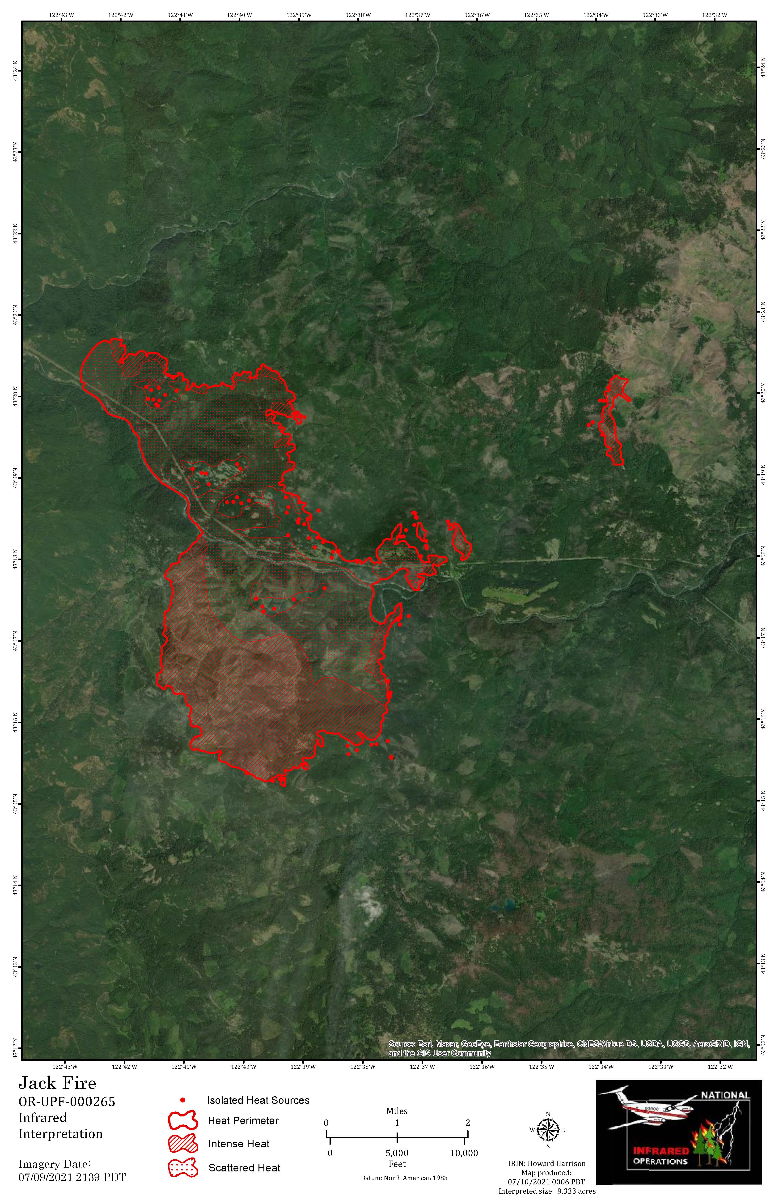
July 10 2021 Jack Fire Daily Update
Related Incident:
Publication Type: News
Northwest Incident Management Team 9 (IC Brian Goff)
Oregon State Fire Marshal Blue Incident Management Team (IC Scott Magers)
InciWeb: https://inciweb.nwcg.gov/incident/7605
Facebook: https://fb.me/JackFire2021
Fire Update: Saturday, July 10, 2021
Fire information: The Jack Fire is currently estimated at 9,333 acres and is 10% contained. Fire crews continue to scout and construct primary, alternate, and contingency containment lines around the fire. North of Highway 138E, crews are burning vegetation along containment lines and holding the fire south of Ragged Ridge. Crews are securing lines along Ragged Ridge and continuing to carry those lines to the east. Crews are also securing lines between Dry Creek community and the fire. The Jack Fire is also well-established south of Highway 138E in the 2002 Apple Fire scar. We are actively looking for opportunities to contain the southern side of the fire.
Structures: Firefighters will be burning vegetation along lines to increase security around private property in the Dry Creek area. This removal of fuels will help protect the private structures and resources if the main body of the fire approaches this area. Additional OSFM crews will be in the Dry Creek area to provide extra protection. OSFM structural crews will also assess and build defensible space around structures in the Boulder Flats area.
Aviation: Yesterday, four Type 1 helicopters and one Type 3 helicopter provided support to ground crews in the afternoon. A strong smoke inversion Friday morning created poor visibility and prevented aircraft from flying until later in the day.
Evacuations: All Forest Service campgrounds (Apple Creek, Horseshoe Bend and Eagle Rock) are on Level 3 evacuation GO order. The Dry Creek community as well as all residences on the Illahee Road are also in Level 3 evacuation GO order. Level 2 SET evacuations were issued from mile marker 38 to 43. This includes Steamboat Inn and residences located on Brindle Bug Road, Steelhead Caddis Road, and residences and businesses located between mile post 51 and 55 on Highway 138E. Please visit the Douglas County Sheriff’s Office interactive evacuation map: www.dcso.com/evacuations
Closures: State highway 138E from Steamboat Creek to mile post 55 is closed to vehicle traffic. Steamboat Inn is also closed. Oregon Department of Transportation has set an eastside ‘soft closure’ checkpoint at Lemolo Lake junction to allow for local access into nearby recreation areas, including Lemolo Lake. Please visit https://tripcheck.com/ for updates on road closures. The Umpqua National Forest has issued an area closure around the Jack Fire. The full closure order and map can be viewed on InciWeb or at https://go.usa.gov/xGJSE.
Weather: Forecast for near normal temperatures in the 80’s with winds west to northwest.
Jack Fire Update Sunday July 11 2021
Related Incident:
Publication Type: News
Jack Fire
Northwest Incident Management Team 9 (IC Brian Goff)
Oregon State Fire Marshal Blue Incident Management Team (IC Scott Magers)
Email: 2021.jack@firenet.gov
Phone: 541-201-2335
Hours: 8am-6pm
InciWeb: https://inciweb.nwcg.gov/incident/7605
Facebook: https://fb.me/JackFire2021
Fire information: The Jack Fire is currently estimated at 10,937 acres and is 10% contained. In the northwest section of the fire near Steamboat, crews have completed handline and conducted mop up 20 feet inside of the perimeter along the 4713 Road. Mop-up involves seeking out and cooling of heat sources. Today these crews will maintain, secure, and mop-up the line moving to the east utilizing dozers, handline, and hose lays. On the western edge of the fire, resources continue to brush out vegetation while holding and securing the line along the river and HWY 138. On the eastern flank, crews continue burning vegetation along containment lines moving south towards Dry Creek. In the southeast, near Dry Creek, resources have burned vegetation along containment lines to connect the 4760 Road to the areas that have been cleared of vegetation near Dry Creek and Illahee Road. The most active area of the fire is south of the river and HWY 138. Firefighters have established locations that are suitable for containment lines while providing for firefighter safety. Crews working on all sections of the fire face steep terrain and poison oak related difficulties.
Structures: Structure crews and Douglas Forest Protective Association continue to support fire operations in the Dry Creek area creating defensible space on private property and assessing structures for fuel removal. Task forces are also moving east along HWY 138, scouting additional homes and buildings for fire prevention groundwork. To date, firefighters have successfully protected community with zero structure loss.
Jack Fire Statistics:
Acres: 10,937
Containment: 10%
Personnel: 781
Date of Ignition: 7/5/2021
Cause of Fire: Under Investigation
Structures Threatened: 243
Injuries: 8
July 12 2021 Jack Fire Daily Update
Related Incident:
Publication Type: News
Jack Fire Statistics:
Acres: 12,533
Containment: 10%
Personnel: 809
Date of Ignition: 7/5/2021
Cause of Fire: Under Investigation
Structures Threatened: 243
Injuries: 8
Aircraft: 4 Dozers: 5 Engines 44
Fire Update: Monday, July 12, 2021
Fire information: The Jack Fire is currently estimated at 12,533 acres and is 10% contained. In areas north of HWY 138 firefighters made significant progress yesterday expanding areas cleared of fuel to strengthen containment lines. Near Steamboat, crews will continue to hold, secure, and mop-up the line moving to the east along the 4713 Road towards Dog Mountain. On the eastern flank, crews continue burning vegetation along containment lines moving south towards Dry Creek and north to connect with lines established along the 4713 Road. In the southeast, near Dry Creek, resources continue to burn vegetation along containment lines connecting the 4760 Road to the areas that have been cleared of vegetation near Dry Creek and Illahee Road. On the western edge of the fire, resources continue to brush out vegetation while holding and securing the line along the river and HWY 138.
In areas south of HWY 138 the fire continues to be active. Today firefighters will hold and secure the 4714 Road on the western edge of the fire to establish an anchor point. An anchor point is an advantageous location, usually a barrier to fire spread, from which to start constructing a containment line. The anchor point is used to minimize the chance of being flanked by the fire while the line is being constructed. On the eastern edge of the fire, crews have begun constructing line by connecting existing trails and roads with handline. On the southern section of the fire resources continue to scout and prepare locations that are suitable for containment lines. Crews working on all sections of the fire face steep terrain and poison oak related difficulties.
Structures: Firefighters continue supporting fire operations in the Dry Creek residential area with the goal of securing the burn out line to Highway 138 by the end of shift 7/12/21. Structural Task Forces begin demobilizing resources throughout the day today. Douglas Forest Protective Association will complete mission objective work at 1900 hours.
Aviation: Air assets continue to provide ground resources with water and retardant drops to limit the spread of the fire and hold containment lines. Low visibility due to cloud or smoke cover can prevent aircraft from flying.
Evacuations: All Forest Service campgrounds (Apple Creek, Horseshoe Bend and Eagle Rock) are on Level 3 evacuation GO order. The Dry Creek community as well as all residences on the Illahee Road are also in Level 3 evacuation GO order. Level 2 SET evacuations were issued from mile marker 38 to 43. This includes Steamboat Inn and residences located on Brindle Bug Road, Steelhead Caddis Road, and residences and businesses located between mile post 51 and 55 on Highway 138E. Please visit the Douglas County Sheriff’s Office interactive evacuation map: www.dcso.com/evacuations
Closures: State highway 138E from Steamboat Creek to mile post 55 is closed to vehicle traffic. Steamboat Inn is also closed. Oregon Department of Transportation has set an eastside ‘soft closure’ checkpoint at Lemolo Lake junction to allow for local access into nearby recreation areas, including Lemolo Lake. Please visit https://tripcheck.com/ for updates on road closures. The Umpqua National Forest has issued an area closure around the Jack Fire. The full closure order and map can be viewed on InciWeb or at https://go.usa.gov/xGJSE.
Weather: Today will be sunny with some areas of smoke. Temperatures will be between 82-92 with relative humidity ranging from 22-26%. Winds will be light from the northeast to northwest becoming gusty after 2 p.m.
Air Quality: Smoke production and movement today and tomorrow should follow a pattern similar to yesterday, with light winds moving smoke to the south/southeast during the day, then down-slope air movement overnight. The Toketee area will have continued air quality impacts as smoke flow up-drainage during the day. Air quality at Crater Lake, Shady Cove, and Medford should be similar to yesterday with periods of improved conditions in the Crater Lake and Medford areas this evening. In the Shady Cove area, conditions will likely remain smoky overnight as smoke settles in the Rogue River drainage. Minimal, temporary smoke impacts may occur in Glide and Roseburg, and none are expected in Oakridge and Cottage Grove. For more air quality and smoke impacts visit https://oregonsmoke.blogspot.com
July 13 2021 Jack Fire Daily Update
Related Incident:
Publication Type: News
Jack Fire
Northwest Incident Management Team 9 (IC Brian Goff)
InciWeb: https://inciweb.nwcg.gov/incident/7605
Facebook: https://fb.me/JackFire2021
Fire Update: Tuesday, July 13, 2021
Fire information: The Jack Fire is currently estimated at 13,795 acres and is 15% contained. The increase in acres is within the planned control lines. North of HWY 138, firefighters continue to make good progress to strengthen, hold and secure containment lines in the northern and eastern portions of the fire. Mop-up continues along the perimeter of the fire. Crews continue burning vegetation along containment lines moving south towards Dry Creek and north to connect with lines established along the 4713 Road. In the Dry Creek area, crews plan to complete work burning vegetation around the structures to prevent fire encroachment.
South of HWY 138, crews have established anchor points on the western and eastern flanks. Working from the anchor points near Twin Lakes, crews are utilizing trails, roads, and hand lines to hold the fire near Calf Creek. On the western perimeter of the fire, crews are holding the line and will continue to burn vegetation where necessary to prevent fire spread east of the 4714 road. On the southern-most edge of the fire, resources continue to prepare containment lines while also scouting for control line options closer to the fire’s active front.
Structures: Oregon State Fire Marshal’s Task Forces have demobilized and delegation of authority transferred back to Douglas Forest Protective Association. Structures have been prepped, structure protection enhance and will be monitored by DFPA and NW Team 9.
Aviation: Air assets continue to provide ground resources with water and retardant drops to limit the spread of the fire and to help establish and hold containment lines. Aviation and fire crews coordinate with resource advisors to protect area water resources, reduce spread of invasive species and minimize impacts of fire suppression tied to water and retardant drops.
Evacuations: All Forest Service campgrounds (Apple Creek, Horseshoe Bend and Eagle Rock) are on Level 3 evacuation GO order. The Dry Creek community as well as all residences on the Illahee Road are also in Level 3 evacuation GO order. Level 2 SET evacuations were issued from mile marker 38 to 43. This includes Steamboat Inn and residences located on Brindle Bug Road, Steelhead Caddis Road, and residences and businesses located between mile post 51 and 55 on Highway 138E. Please visit the Douglas County Sheriff’s Office interactive evacuation map: www.dcso.com/evacuations
Closures: State highway 138E from Steamboat Creek to mile post 55 is closed to vehicle traffic. Steamboat Inn is also closed. Oregon Department of Transportation has set an eastside ‘soft closure’ checkpoint at Lemolo Lake junction to allow for local access into nearby recreation areas, including Lemolo Lake. Please visit https://tripcheck.com/ for updates on road closures. The Umpqua National Forest has issued an area closure around the Jack Fire. The full closure order and map can be viewed on InciWeb or at https://go.usa.gov/xGJSE.
Weather: Temperatures again in the 90’s today with relative humidity at 20%. Winds will be light from the east northeast in morning, changing west northwest in afternoon, with gusts up to 15 miles per hour.
July 14 2021 Jack Fire Daily Update
Related Incident:
Publication Type: News
Fire Update: Wednesday, July 14, 2021
Fire information: The Jack Fire is currently estimated at 13,907 acres and is 15% contained. Cooler temperatures and higher relative humidity the next few days will help resources hold the fire within the planned containment line. North of HWY 138, Crews will continue to hold, secure and mop-up along the 4760 Road moving east towards Dog Mountain. Firefighters will burn vegetation away from containment lines in the northeastern corner of the fire perimeter as needed to hold the fire within the planned containment area. In the Dry Creek area, crews continue mop-up around the structures.
South of HWY 138, on the western perimeter of the incident, the fire continues to move south along the 4714 road. Crews will continue to hold the fire east of the road, burning out vegetation as needed to strengthen the line. Crews are utilizing trails, roads, and hand lines to hold the fire within the planned containment lines on the southern-most edge of the fire. Today, firefighters will hold established containment lines while preparing lines to the south.
Structures: Structures have been prepped, structure protection enhanced and will be monitored by NW Team 9 and the Douglas Forest Protective Association.
Aviation: Four Type 1 aircraft and two Type 3 aircraft continue to support firefighters on the ground. Type 1 aircraft include Sikorsky and Kaman 1200 (KMax) helicopters along with a Type 3 A-Star helicopter. Air assets provide ground resources with water and retardant drops to limit the spread of the fire and to help establish and hold containment lines.
Evacuations: All Forest Service campgrounds (Apple Creek, Horseshoe Bend and Eagle Rock) are on Level 3 evacuation GO order. The Dry Creek community as well as all residences on the Illahee Road are also in Level 3 evacuation GO order. Level 2 SET evacuations were issued from mile marker 38 to 43. This includes Steamboat Inn and residences located on Brindle Bug Road, Steelhead Caddis Road, and residences and businesses located between mile post 51 and 55 on Highway 138E. Please visit the Douglas County Sheriff’s Office interactive evacuation map: www.dcso.com/evacuations
Closures: State highway 138E from Steamboat Creek to mile post 55 is closed to vehicle traffic. Steamboat Inn is also closed. Oregon Department of Transportation has set an eastside ‘soft closure’ checkpoint at Lemolo Lake junction to allow for local access into nearby recreation areas, including Lemolo Lake. Please visit https://tripcheck.com/ for updates on road closures. The Umpqua National Forest has issued UPDATED closure orders around the Jack Fire. The full closure order and map can be viewed on Forest website at www.fs.usda.gov/umpqua and on the Jack Fire Facebook page.
Weather: Cooler temperatures in the 80’s today. Winds will be light from the east northeast in morning, changing west northwest in afternoon, with gusts up to 15 miles per hour.