
Single Publication
Fish Creek Fire Update; Monday 08-26-2024
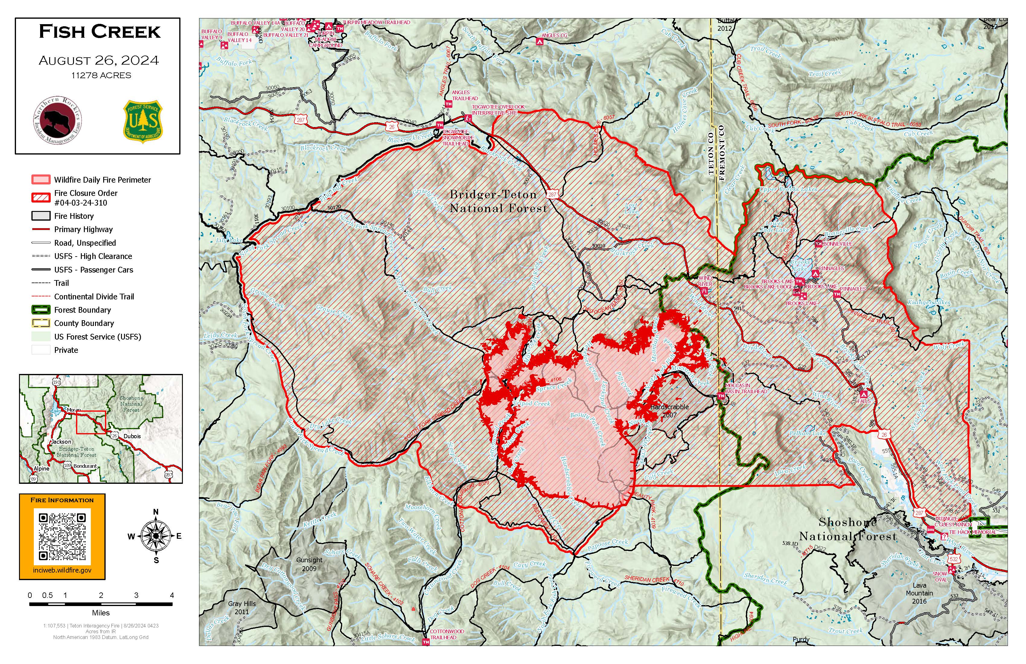
Publication Type: News - 08/26/2024 - 09:12
Northern Rockies Team 1, Incident Commander Brent Olson
Location: 7 miles SW of Togwotee Pass
Start Date: Friday, August 16, 2024
Cause: Lightning
Size: 11,278 acres
Percent complete: 23%
Resources: 331 Total Personnel; 1 Masticator; 1 Feller Buncher; 5 Helicopters; 8 Hand Crews; 13 Engines
KEY MESSAGE:
A Fish Creek Fire Community Meeting is planned for today from 6 to 7pm in the Poolaw Building at the National Museum of Military Vehicles just east of Dubois, Wyoming. Fire managers and local officials will provide an overview of the status of the fire, fire suppression efforts, and the closure area.
Current Status:
Cooler weather conditions yesterday allowed firefighters the opportunity to scout indirect fire line locations in locations primarily northwest, north, and northeast of the active fire area relative to the values identified to be at risk from fire activity. Indirect fire line construction was improved from Highway 26 to Pilot Knob with additional indirect line construction continuing south toward the Moccasin Basin Trailhead. Firefighting resources utilized heavy equipment to reduce vegetation along Deception Road to prepare it as an indirect control line. On the southwest corner firefighters conducted a small firing operation near Red Creek to secure the uneven fire edge. Structure protection crews continued to install pumps, hose, and sprinklers in the Brooks, Pinnacle and Breccia areas. Additional firefighting crews and equipment have been ordered and are arriving to support work on the fire.
Today, the scouting and planning of indirect fire line will continue relative to protecting the values at risk. Some of the areas where crews will be working include the Holmes Cave Trail and Spread Creek tying into the Flagstaff Road. A lot of the indirect line work is focusing on the areas north of Highway 26 and northwest of the fire based on the forecast of warmer and drier conditions later this week. Structure protection crews plan to complete prep work in Brooks, Pinnacle and Breccia and then shift to additional locations to begin more structure assessments.
This incident is being managed under a confine/point protection strategy. Confine is a wildfire response strategy of restricting a wildfire to a defined area, primarily using natural barriers that are expected to restrict the spread of the wildfire under the prevailing and forecasted weather conditions. Point protection may include the installation of pumps, sprinkler systems, vegetative fuels reduction, and other measures to protect identified values-at-risk. The “percent complete” figure associated with the incident refer to the degree to which these actions have been accomplished.
Weather and Fire Behavior:
Today will be cooler and wetter on the end of a weather system departing the area. Expect showers and thunderstorms to decrease through the rest of the morning. Winds will be lighter out of the west with gusts mostly remaining below 20 mph. Given the moisture, humidity will remain above 45 percent through the afternoon. Conditions become warmer and drier on Tuesday.
The wetting rain overnight and continuing into today will reduce fire activity for today’s shift. Sage/grass, meadow systems, and the 2007 Hardscrabble Fire footprint will serve as a barrier to spread today. Pockets of dead and down timber will continue to burn with smoldering and creeping fire behavior. Primarily low flame lengths and rates of spread are likely today in timber.
AIR QUALITY AND SMOKE:
Air quality and smoke conditions and forecasts can be found at https://www.airnow.gov/.
Closures and Evacuations:
A joint Closure Order for the fire area has been issued by the Bridger-Teton and Shoshone National Forests for public and firefighter safety. Please do not enter the closure area or use the Forest Roads that are closed.
The Fish Creek Area, Roads, and Trails Closure Order (map) has been established for public and firefighter safety in the fire area. Full details can also be found at https://www.fs.usda.gov/alerts/btnf/alerts-notices.
Fremont County: Brooks Lake, Pinnacle Drive and Breccia Drive area remain in the Level 2 Evacuation notice. A Level 2 Evacuation means “Be Set” to evacuate. You must prepare to leave at a moment’s notice. This level indicates there is significant danger to your area, and residents should either voluntarily relocate to a shelter or with family/friends outside of the affected area, or if choosing to remain, to be ready to evacuate at a moment's notice. See the alert notice on the Fremont County Fire Protection District Facebook page.
Teton County: The Teton County Division of Emergency Management utilizes a Ready, Set, Go www.tetoncountywy.gov/1846/Ready-Set-GO system for evacuation messaging. All residents should be in the Ready status by preparing for evacuations and becoming fire adapted.
US HWY 26/287 continues to experience smoke and sometimes limited visibility. Wyoming Department of Transportation (WYDOT) is working closely with Fremont County Emergency Management and fire officials for the safety of motorists and firefighters. Drivers are encouraged to visit https://www.wyoroad.info/ prior to traveling on US HWY 26/287 for road status and information, or download the Wyoming 511 app at https://www.wyoroad.info/511/WY511Mobile.html to monitor for any changes due to fire activity.