
Single Publication
Could not determine your location.
 Wildfire
 Prescribed Fire
 Burned Area
Response
Burned Area
Response Other
Other
Williams Mine Fire-GPNF
Unit Information
Incident Contacts
- Mt. Adams Ranger DistrictPhone:509-395-3402Hours:8 a.m. to 4:30 p.m. Mon. - Sat.
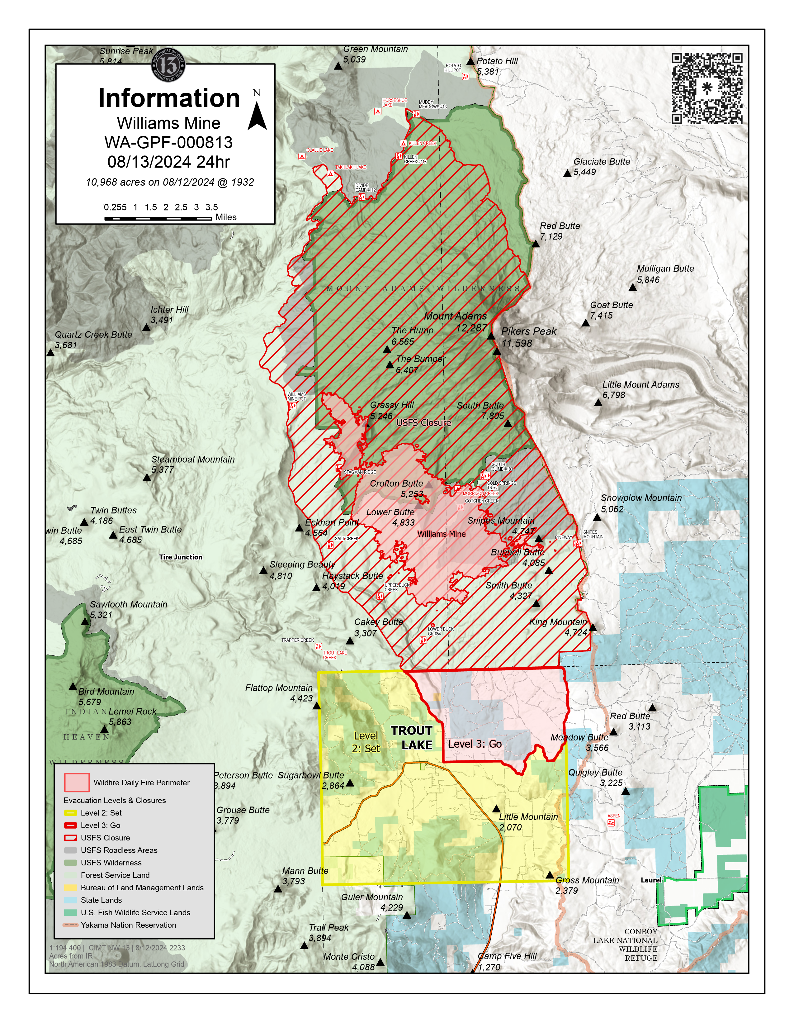
Williams Mine Fire Update 08-13-2024
Williams Mine Fire-GPNF
Publication Type: News - 08/13/2024 - 08:46
Williams Mine Fire Update for Tuesday, August 13, 2024
KEY MESSAGES:
Scooper planes continue to dip out of Swift Reservoir and the Columbia River between Memaloose Island and Lyle, Washington. Members of the public should be aware that scooper planes could approach and dip out of these water sources at any time as weather conditions allow for aviation operations. Firefighters have established southern perimeter control lines that at this time have stopped southerly fire progression.
CURRENT STATUS:
Yesterday, a new start on the northwest edge of the fire was detected. Local ranger district initial attack resources worked with NW-13 to access the incident. The ¼ acre area is fully lined and contained.
On the southeast edge of the Williams Mine fire perimeter, crews continue to work on containing spot fires around and past Snipes Mountain to the east. An egress route for the safety of engaged resources has been established on the 312 road. Crews have successfully anchored into the 840 road where dozers are tying in control lines, and hand crews continue to work along the extent of the road systems prepping indirect lines in coordination with the heavy equipment operations. Work resumed on the 8031 road and crews have established control lines along the 731 road that tie into historic dozer lines from the 2012 Cascade Creek Fire.
The structure protection group continues to work around the Trout Lake community in conjunction with the Glacier Spring Water Group. Triage efforts and assessments will continue around private properties until evacuation levels can be safely rescinded.
WEATHER / FIRE BEHAVIOR:
Stronger westerly winds arrived in the area Monday, and relative humidity values did rise above 60% below the 4000 feet elevation band on the fire. Active burning was observed yesterday but atmospheric conditions were more favorable than previous days for suppression efforts. Sunny skies and wind will remain through Tuesday, with winds weakening and turning northwesterly on Wednesday. Instability will begin to increase on Thursday and through the weekend, resulting in a continuation of potentially active fire behavior.
CLOSURES:
Washington DNR managed lands near Trout Lake and Glenwood are closed to entry due to the Williams Mine fire. For more information, please see http://www.dnr.wa.gov/ahtanum. The Confederated Tribes and Bands of the Yakama Nation, Tract D Recreation Area is closed, please see Yakama Tract D Road Closure for more information. Level 2 & 3 evacuations are in effect for the community of Trout Lake. An evacuation center is located at 1455 NW Bruin County Road, White Salmon, Washington. Evacuations are coordinated through the Klickitat County Sheriff’s Office and the Skamania County Sheriff’s Office. The FS-23 and FS-25 roads are closed, see the Williams Mine Area and Road Closure for more details. The Pacific Crest Trail (PCT) is closed from the PCT's intersection with FS 23 to Potato Hill. The closure spans the entire Mt. Adams Wilderness.