
Single Publication
Could not determine your location.
 Wildfire
 Prescribed Fire
 Burned Area
Response
Burned Area
Response Other
Other
Williams Mine Fire-GPNF
Unit Information
Incident Contacts
- Mt. Adams Ranger DistrictPhone:509-395-3402Hours:8 a.m. to 4:30 p.m. Mon. - Sat.
Williams Mine Fire Update 08-11-2024
Williams Mine Fire-GPNF
Publication Type: News - 08/11/2024 - 09:19
Williams Mine Fire Update for Sunday, August 11, 2024
KEY MESSAGES:
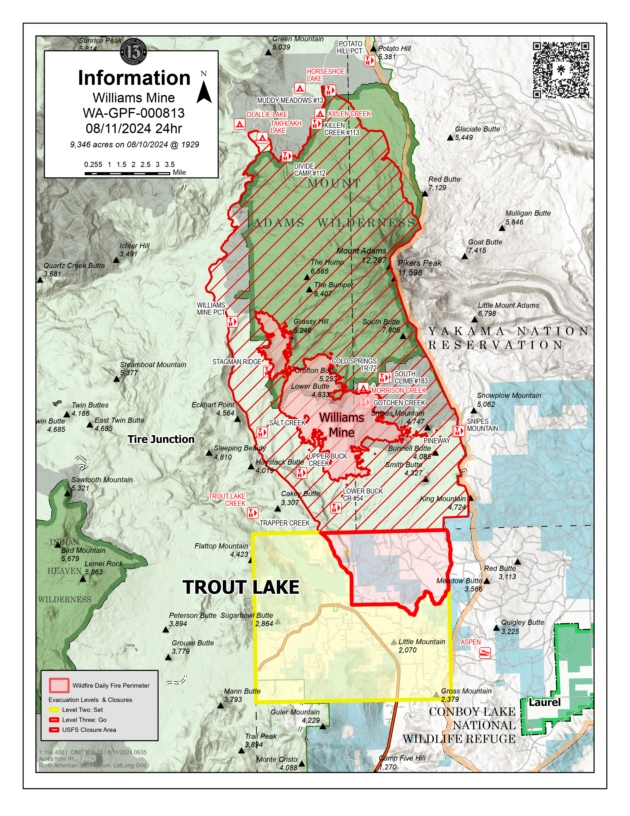
To protect the community while suppressing the Williams Mine Fire, NW-13 has established an incident command post in Trout Lake. Incident officials recognize the inconvenience and appreciate your patience as fire engines, crew-carriers and heavy machinery navigate to and from the fire perimeter through the community. NW-13 continues to work with local officials to prioritize protection efforts for the community of Trout Lake, which is south of the fire and the community of Glenwood, east of the fire.
Night operations were established last night to assess fire growth, prioritize operational engagement and enhance day shift firefighting efforts around the southern perimeter of the incident.
The fire perimeter experienced primarily eastern progression yesterday, and the main eastern flank of the fire is now approximately 2.5 miles away from the Yakama Nation tribal land boundary, near the Pineway Trailhead. Several small spot fires are further east, an estimated 1-2 miles away from the closest point of the Yakama Nation tribal land boundary, around the base of Snipes Mountain.
CURRENT STATUS:
The Williams Mine Fire is currently burning primarily within the 2012 Cascade Creek fire scar, with dense brush and heavy dead/down vegetation. These fuels have led to rapid fire growth and are responsible for heavy smoke and the visible plumes over the fire area. Yesterday, due to intense winds, spot fires were established approximately one mile ahead of the main body of fire on the eastern flank. The fire is expected to move upslope towards Mt. Adams, through the previous burn scar.
Heavy equipment are establishing an anchor point where firefighters can safely construct fire line in order to generate potential containment opportunities and stop forward fire perimeter progression. Masticators are working on roadways to create fire breaks to support primary and contingency containment lines. Firefighters will continue to assess/validate indirect options to the east of the fire to minimize easterly progression, with the predominantly westerly wind pattern.
Two Type 1 helicopters were assigned to the fire yesterday. The Yakama Nation assisted with reconnaissance operations utilizing a Type 3 helicopter. This coordinated effort allows fire managers to develop situational awareness and identify potential control features. Scooper planes will continue to be utilized on the fire and are being filled in the Columbia River. They currently are operating between Memaloose Island and Lyle, Washington. Fire managers ask residents and visitors to be mindful as they recreate around waterways in proximity to the fire area as an aid in public safety.
CLOSURES:
Level 2 & 3 evacuations are in effect for the community of Trout Lake. An evacuation center is located at 1455 NW Bruin County Road, White Salmon, Washington. Evacuations are coordinated through the Klickitat County Sheriff’s Office and the Skamania County Sheriff’s Office. The FS-23 and FS-25 roads are closed, see the Williams Mine Area and Road Closure for more details. The Pacific Crest Trail (PCT) is closed from the PCT's intersection with FS 23 to Potato Hill. The closure spans the entire Mt. Adams Wilderness.