Single Publication
Could not determine your location.
 Wildfire
 Prescribed Fire
 Burned Area
Response
Burned Area
Response Other
Other
Town Gulch
Unit Information
Incident Contacts
- Southern Area Blue CIMTEmail:Phone:541-208-7092
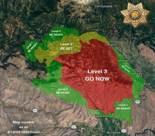
Evacuations Update for Town Gulch Fire | Baker County Sheriff's Office | 08-10-2024
Town Gulch
Publication Type: Announcement - 08/10/2024 - 10:30
Level 3 (GO NOW): The area South of FS Road 7735, 77 road to where it crosses Summit Creek then south of Carson Creek to the Pine Valley floor. The area west of Carson Creek from West Carson Road to Valley View Lane, sest of Mining Channel ditch from Valley View Lane to Jackson Lane, west of Foothill Ditch from Jackson Lane to the ODF Boundary Line, then west of the ODF boundary line to Highway 86. The area North of the ODF Boundary from Highway 86 to the 77 Road to Immigrant Gulch, north of where the Brooks Ditch crosses the Eagle Valley Rural Fire Protection District Boundary to Summit Creek where it meets Summit Creek Road, north of Summit Creek Road to Eagle Creek Road, then north of the Idaho Power line from Eagle Creek Road to Sparta Lane. The area east of Sparta Lane from the Idaho Power Line to Mitchell Road. East of Mitchell Road to Eagle Creek. Then east of 7737 to the 7737 and 7735 intersection.
Level 2 (BE SET): North of Shanghai Creek on the west side of the fire and then north of Carson creek on the east side of the fire. The area east of the headwaters of Puzzle Creek to Dempsey Creek, then east of Paddy Creek. The area south of the FS Road 7725/77 intersection to Fuller Creek. The area west of Cornucopia Highway between Fuller Creek and West Carson Lane.
Level 1 (BE READY): West of the Cornucopia Highway starting near the intersection of the Cornucopia Highway and Allstead Lane all the way to Highway 86. West of Highway 86 to Immigrant Gulch. North of the intersection of Immigrant Gulch and Highway 86. North of the rock pit and the Tobin Ditch to Carnahan Lane. North of Sparta Lane from Old Foothill Road to the intersection of Sparta Lane and the Idaho Power line. From this intersection, the boundary becomes the Idaho Power Line to Thorn Gulch over to Gem Mine Road. East of Sparta Butte Road, FS Road 7005 to Forshey Meadow and then east of the FS Road 70 to the FS Road 7015. South of Empire Gulch on the west side of the fire and the intersection of Allstead Road and the Cornucopia Highway on the east side of the fire.