Single Publication
Could not determine your location.
 Wildfire
 Prescribed Fire
 Burned Area
Response
Burned Area
Response Other
Other
Emergency response team shares soil-burn severity map and research from Lookout Fire
Lookout Fire
Publication Type: Announcement 10/10/2023
Emergency response team shares soil-burn severity map and research from Lookout Fire
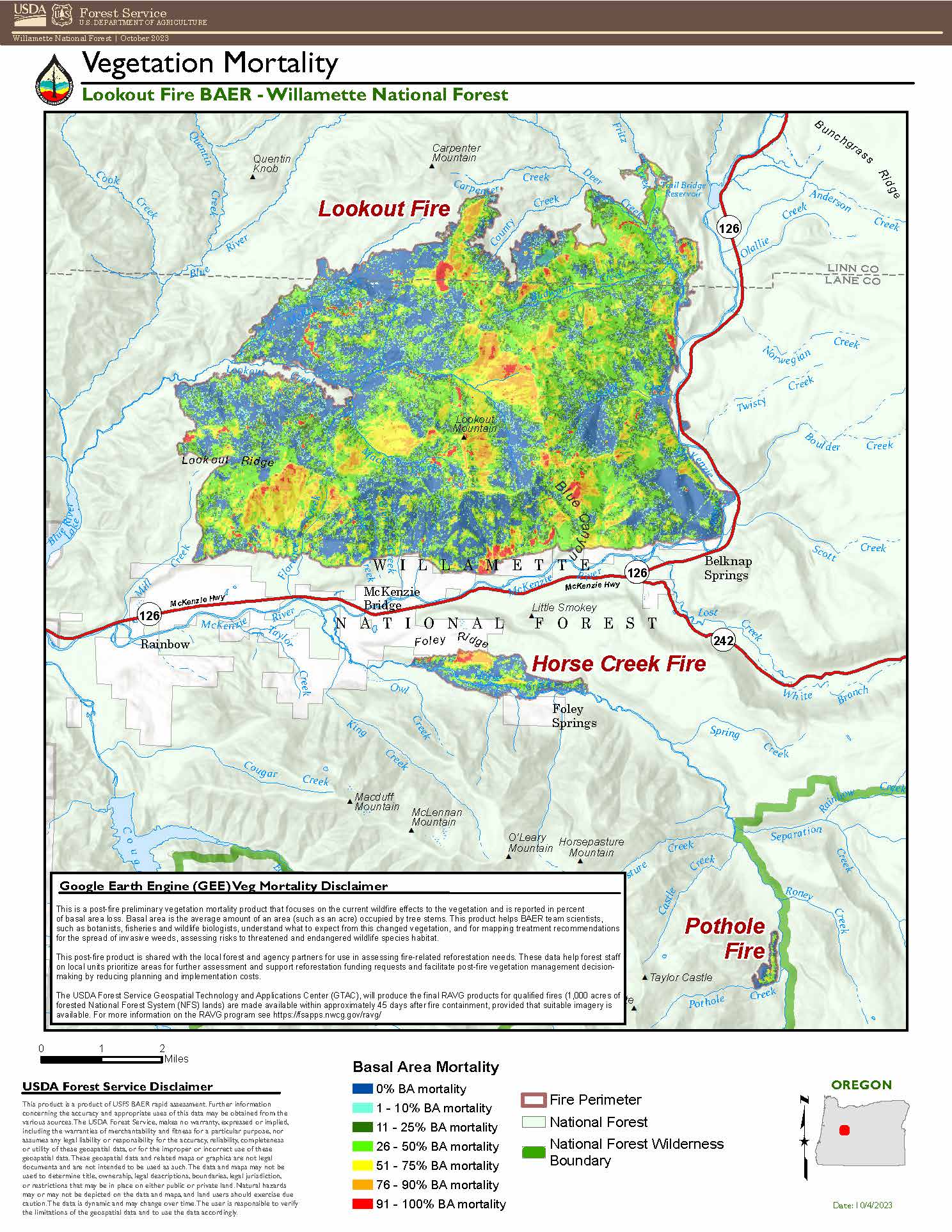
Field surveys, satellite images provide a picture of burned areas and soil stability
Springfield, Ore. – Oct. 5, 2023 — Today, an Emergency Response Team of resource specialists released their findings on the Lookout Fire, Horse Creek, and Pothole fires burned areas, following field surveys and assessments.
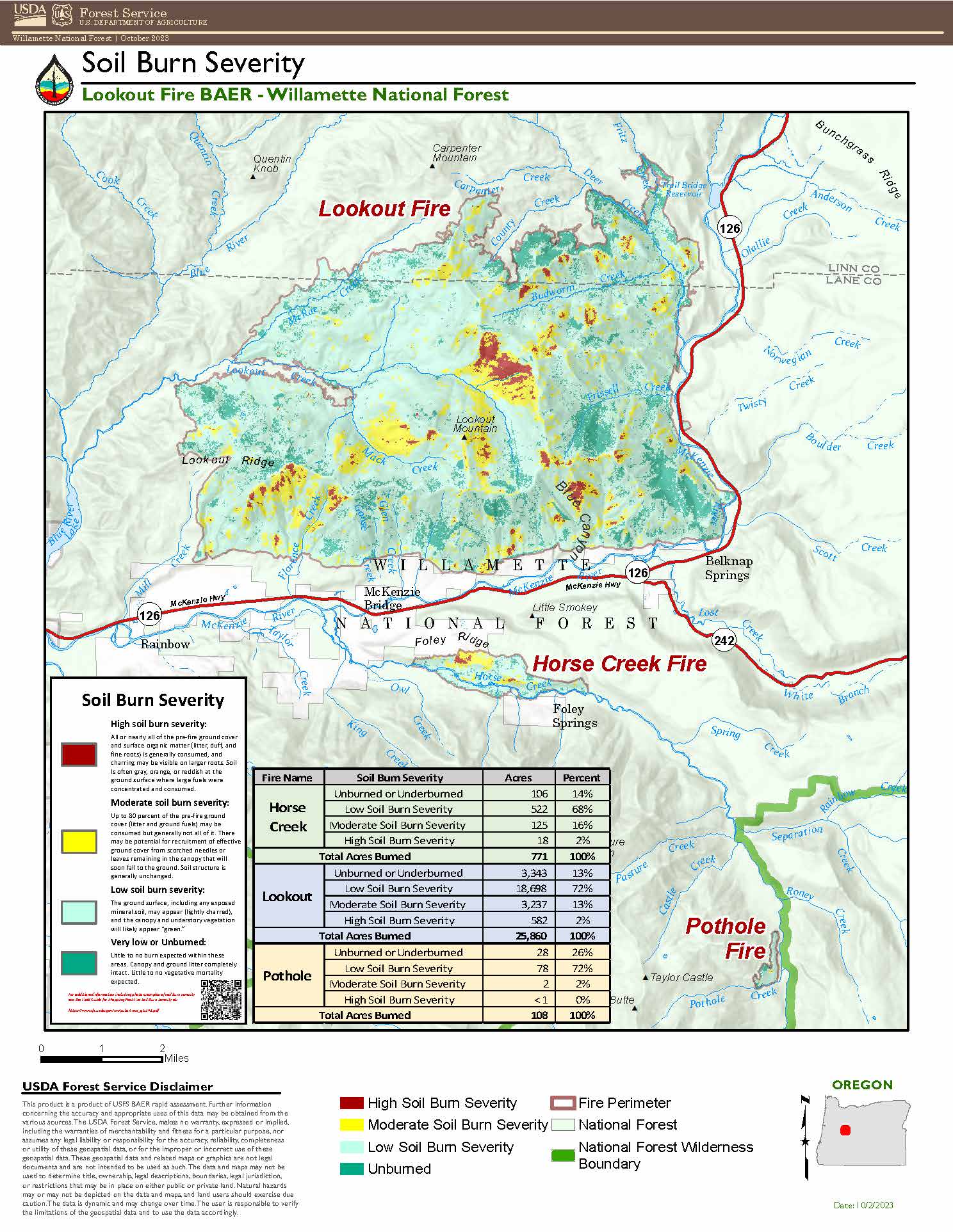
The Burned Area Emergency Response (BAER) Team is an Emergency Response program aimed at managing imminent, unacceptable risks to human life, safety and property, as well as threats to critical natural and cultural resources, from post-wildfire conditions. BAER Team members closely assess watersheds for post-fire, rain-related impact, such as flooding, debris-flow potential, and increased soil erosion. The team then recommends time-critical treatments to complete before the first damaging storm event and creates a soil burn severity map for the fires.
The Lookout Fire map identifies 2 percent of the fire area as having high burn severity and 13 percent with moderate burn severity. The remaining 85 percent has low or unburned/underburned severity. For the Horse Creek Fire, the map identifies 2 percent of the fire as high burn severity, 16 percent as moderate burn severity and the remaining 82 percent as low or unburned/underburned severity. Finally, the Pothole Fire area had zero percent high burn severity, 2 percent moderate and the remaining 98 percent as low or unburned/underburned severity.
A soil burn severity map is generated using satellite imagery and validated and adjusted by field surveys, which the BAER team wrapped up this week. The team observed roots below the soil surface were generally unburned and providing soil stability, water able to infiltrate into the soil at deeper depths, and soil structure was not degraded.
“With the majority of these three fire areas experiencing moderate to low soil burn severity, we would expect limited erosion, flooding and risk for debris flows in the coming months,” said BAER Team Leader Wendy Peterman. “Areas with steeper, burned hillslopes that lack ground cover remain at risk of slides and erosion until the vegetation recovers.”
In areas with moderate to high burn severity on steep slopes, the team focused on identifying protection measures for values at risk including developed recreation sites, roads, historic and cultural sites.
High burn severity is evidenced by the consumption of all ground cover and surface organic matter (litter, duff, fine roots), sometimes leaving a layer of ash several inches deep. The higher the burn severity, the less likely soil can absorb rainfall, increasing surface runoff and risk of erosion, debris flows, and flooding. Moderate burn severity areas will have up to 80 percent ground cover consumed, however soil structure is generally unchanged. In areas with low burn severity, the ground often appears lightly charred.
The BAER team is now prioritizing values at risk and developing a suite of emergency actions to mitigate potential hazards. BAER proposals focus on federal lands, but the team will be sharing information about identified hazards with other agencies later this week to help them plan for potential problems. The soil burn severity map is available for viewing and downloading at: https://inciweb.nwcg.gov/incident-information/orwif- lookout-fire
For more information regarding this BAER assessment, please contact Kassidy Kern at (541) 588-2000 or Kassidy.kern@usda.gov.
Follow us on Facebook and Twitter @WillametteNF for more updates.