
Single Publication
Could not determine your location.
 Wildfire
 Prescribed Fire
 Burned Area
Response
Burned Area
Response Other
Other
Durkee Fire
Unit Information

Incident Contacts
- Fire InformationEmail:2024.durkee@firenet.govPhone:541-208-4371Hours:7:00 am - 7:00 pm PDT
Durkee Fire Update for Tuesday, July 31, 2024 07-31-2024
Durkee Fire
Publication Type: News - 07/31/2024 - 10:42
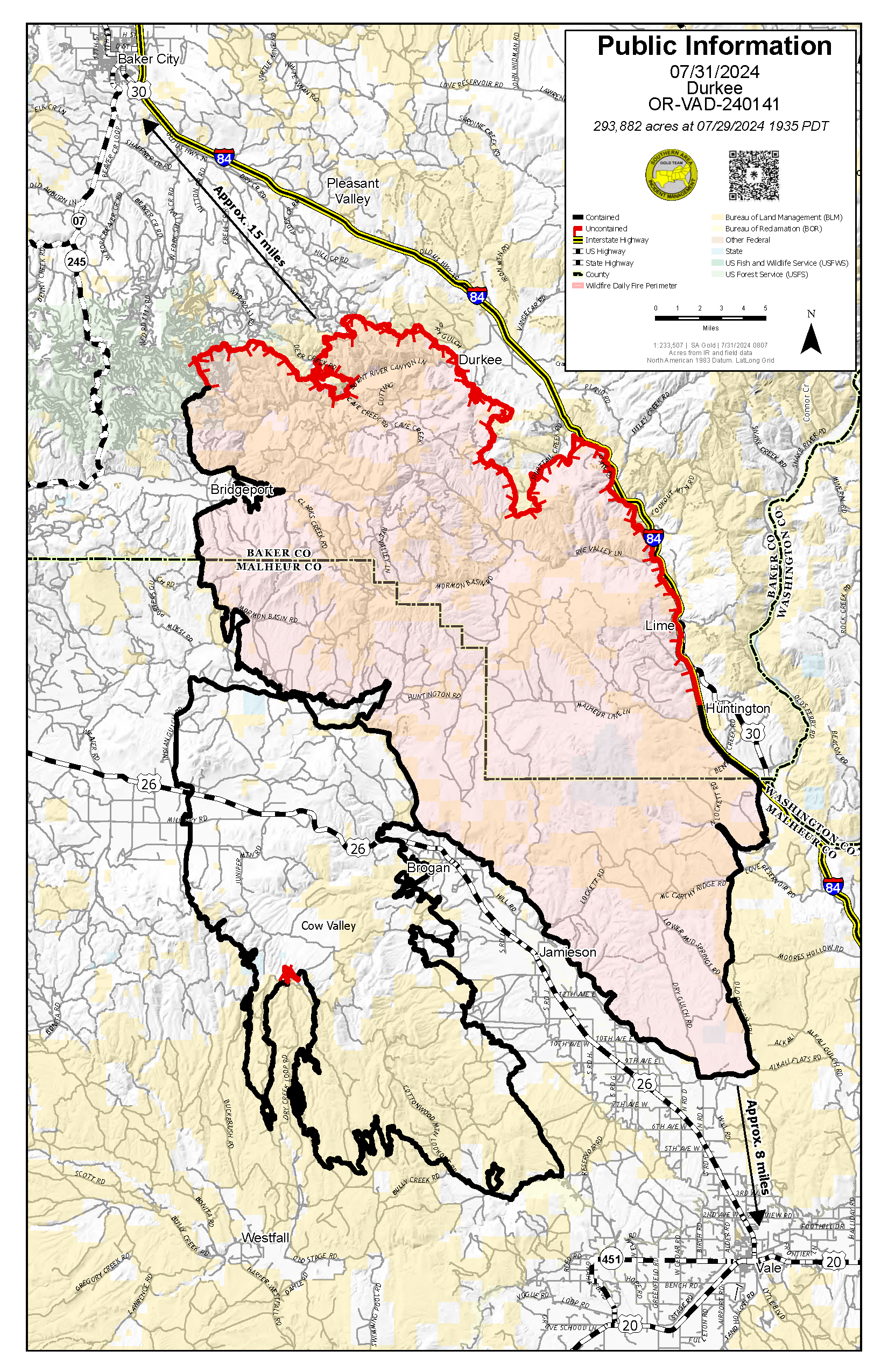
Durkee Fire Update for Wednesday, July 31, 2024
DURKEE FIRE
- Size: 293,882 acres
- Containment: 52%
- Location: 1 mile west of Durkee, OR
- Start Date: July 17, 2024
- Personnel: 481
- Cause: Lightning
Current Situation
Please be mindful of firefighters, equipment and vehicles in the area. As evacuation levels are lowered, more traffic will be on the roads. We ask people in the community to drive carefully and allow our crews and other resources to work safely.
The reported increase in acres on the fire is due to more accurate mapping as firefighters ground truth containment lines.
Firefighters accomplished a lot of work yesterday thanks to higher humidity and lighter winds keeping fire behavior to a minimum. On the fire’s north side, firefighters constructed the last needed piece of control line to secure the area and reduce the need for future strategic firing operations. They also found an old roadbed that will allow engine access to mop up and secure that area if needed in the future. Crews made progress on the mastication project to create a secondary fuel break.
In the Shirttail area firefighters continued the process of cold trailing lines to secure them. This involves feeling by hand to make sure no heat remains in burned materials. Crews also continued removing excess structure protection equipment where it is no longer needed. Across all areas of the fire, firefighters patrolled and mopped up any detected heat.
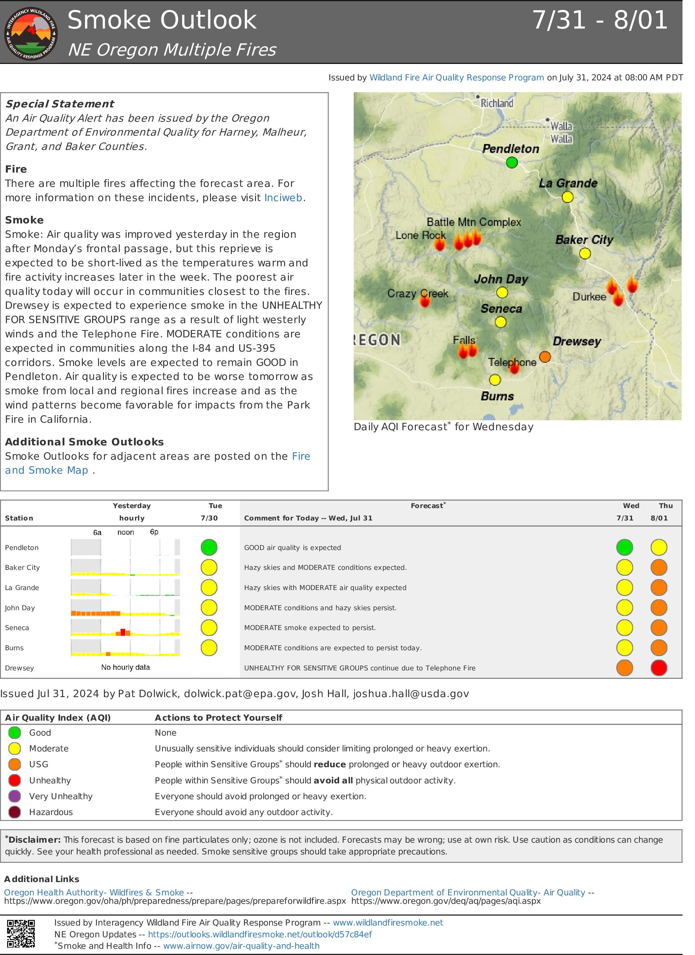
Yesterday, aviation supported the nearby Badlands Complex and Falls Fire.
Today, firefighters will continue to focus on patrolling and securing containment lines, mopping up hot spots and cold trailing. Although it is not showing on satellite data, the night shift reported some heat well inside control lines on the northwest part of the fire. With drier conditions expected, they will focus on locations where yesterday’s higher humidity could have hidden heat from satellite images such as under junipers and in riparian areas. They will also continue removing excess structure protection equipment. Air operations are planned for reconnaissance and for bucket work on the fire’s north end.
Weather and Fire Behavior
The fire area experienced an excellent night of humidity recovery with relative humidities in the 60-80% range. Minimum humidity today will be around 30%. The sunny day could dry out fine fuels, but fire behavior is expected to be low again today. Winds will be light and variable with no gusts over 15 mph expected. Temperatures will gradually climb this week though smoke in the area could reduce temperatures by 2-5 degrees. Relative humidity will be low but less critically dry through Friday. The weekend will bring a chance of thunderstorms with dry lightning and gusty outflows.
Evacuations
Yesterday, the Baker County Sheriff’s Office changed evacuation levels throughout the county (https://www.facebook.com/profile.php?id=100064434892363). Most notably, evacuation levels for Huntington, portions of Rye Valley and Pleasant Valley have been removed. Multiple areas have been reduced to a Level 2 (BE SET) or are no longer under evacuation levels. They ask the public to continue to be vigilant. Weather patterns and fire activity may lead to an increase in evacuation levels.
The Malheur County Sheriff’s Office (https://www.facebook.com/profile.php?id=100069245917855) and the Baker County Sheriff’s Office (https://www.facebook.com/profile.php?id=100064434892363) have issued evacuation orders for multiple areas during the Durkee Fire. Please stay tuned to their Facebook pages for the latest information.
Residents in Level 3 Evacuations “GO NOW” should leave immediately and not return to their property until evacuation levels are lowered. Carry enough supplies to support you and your family for multiple days. A real-time map of fire evacuations is available on the State of Oregon Fire Dashboard (https://www.arcgis.com/apps/instant/portfolio/index.html?appid=22d04c007866419c91ccf00d097526c8).
Closures:
- The Baker County Sheriff's Office has closed Burnt River Canyon Road to non-local, non-emergency traffic.
- I-84 and other highways: Please go to tripcheck.comfor current road closures as the situation is dynamic and subject to change.
- A burn ban is currently in effect for all of Malheur County (https://www.malheurco.org/category/public-notices), and all Bureau of Land Management lands in Malheur and Baker counties.
- A temporary flight restriction remains in effect over the Durkee Fire. More information is available at https://tfr.faa.gov/save_pages/detail_4_6061.html. Please remember, if you fly we can’t! If a drone or other aircraft enters the air space, all firefighting aircraft will be grounded.
Additional Resources:
- For current air quality information, visit fire.airnow.gov.
- Weather and fire behavior could impact transportation, power transmission, cell service and other utilities. Monitor IdahoPower.com for information.