
Single Publication
Could not determine your location.
 Wildfire
 Prescribed Fire
 Burned Area
Response
Burned Area
Response Other
Other
2023 Collett Ridge Fire
Unit Information
Agency Name: U.S. Forest Service
Agency Name: U.S. Forest Service
Incident Contacts
- National Forests in North CarolinaPhone:828-257-4200Hours:8:00am - 4:30pm
Daily Update - Sunday, November 12, 2023
2023 Collett Ridge Fire
Publication Type: Announcement 11/12/2023
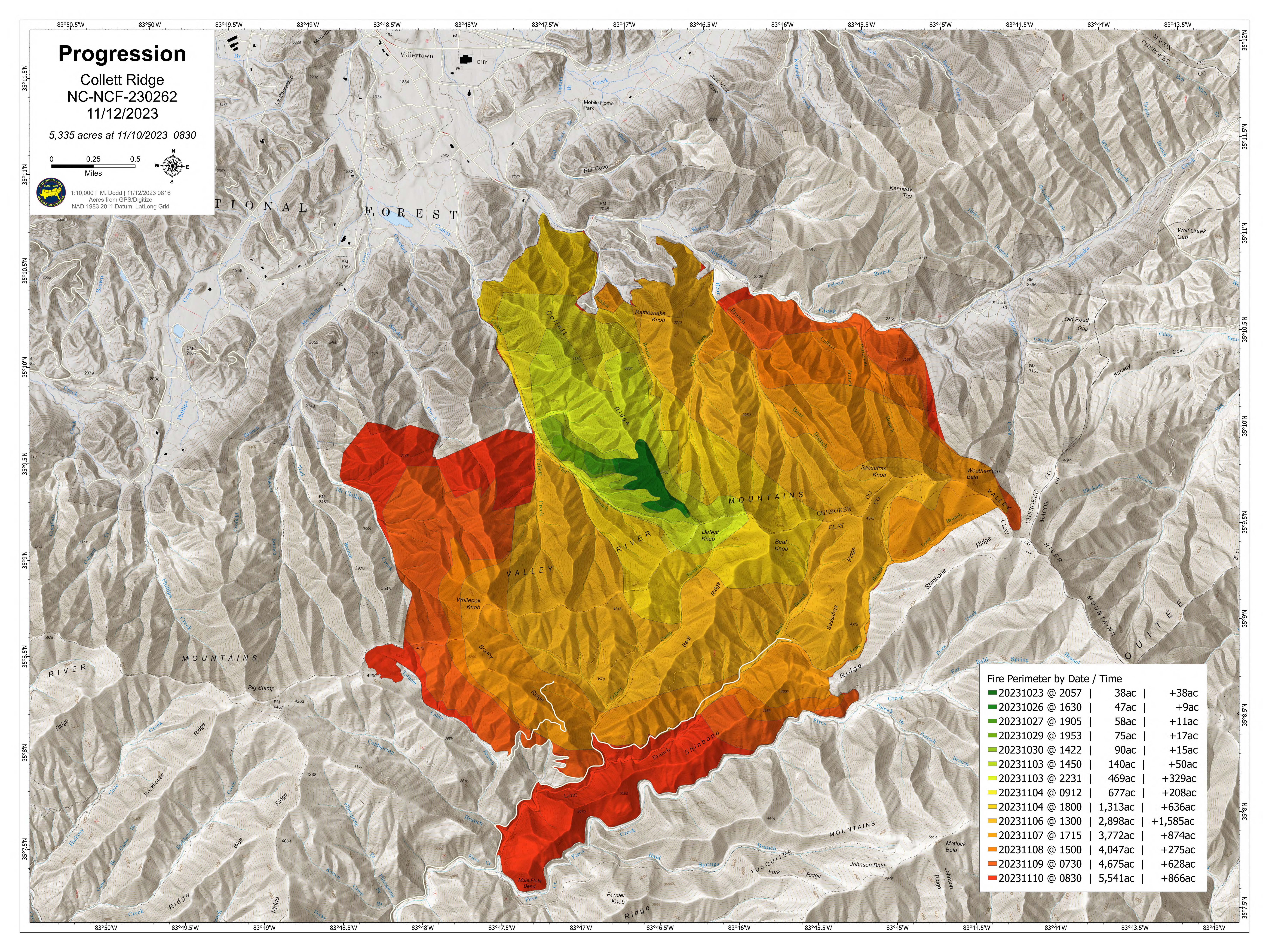
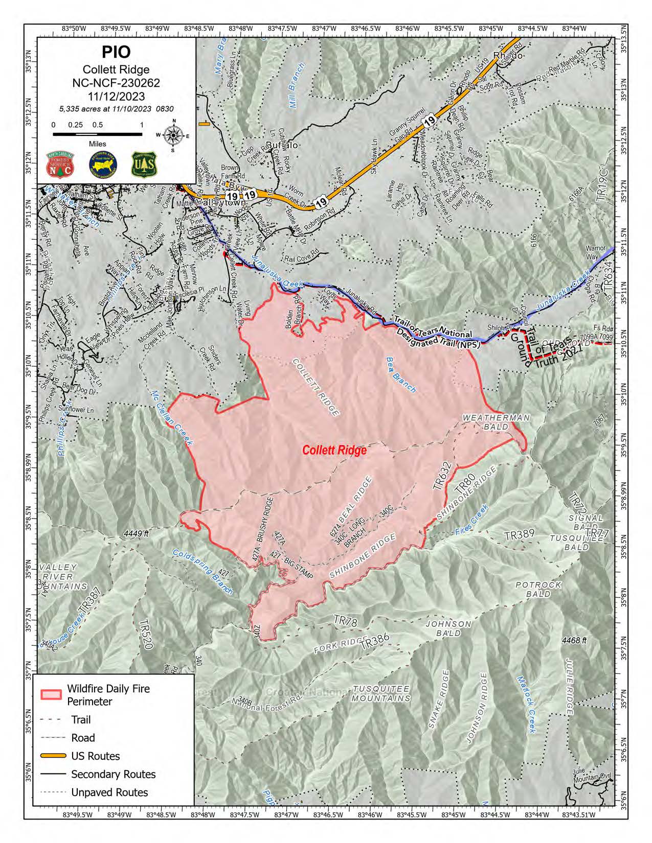
5,335 acres | 18% containment | 263 personnel assigned
Highlights: Fire behavior was minimal again yesterday thanks to the continued cloud cover, cooler temperatures, increased humidity, and precipitation; today’s forecast calls for these conditions to continue through the morning with gradual clearing this afternoon.
Crews completed the hand line between Snider’s Creek Road and McClelland Creek Road yesterday connecting it with the dozer line along the western side of the fire. Construction of hand line will continue from the dozer line south along Polecat Branch to connect in with Forest Road 427 along the southern edge of the fire. Firefighters will begin thinning fire fuels around residences in the Phillips Creek Road and Pisgah Road area as a protection measure from future fires.
Along the northern edge of the fire, crews will continue to patrol near the communities of Bolden Branch, Lord’s Way, and the Kimsey Cove area and perform mop-up operations, such as extinguishing any lingering hotspots, as needed. Fire activity along the southern edge of the fire has been minimal, and crews will patrol the area and perform mop-up operations.
Facebook: https://www.facebook.com/nfsnc/
Resources assigned to the fire includes, five 20-person hand crews, Type 4 and 6 Engines; Dozers; and Water Tenders. Aerial resources include three helicopters.
Weather & Fire Behavior: Any residual light rain or drizzle this morning is expected to diminish today with partial clearing this afternoon. High pressure is forecast to move into the area from the north today into Monday with a period of slow drying the next two to three days. Temperatures will be near, or just below, the seasonal normal for this time of year with highs in the 50s. Winds will be very light.
Until sufficient precipitation occurs on the fire, expect areas of smoldering and isolated creeping. Forest floor leaf litter may continue to burn even with the high relative humidity. Heavy fuel concentrations will retain heat and serve as future heat sources. Primary fire behavior characteristic for the day continues to be limited smoldering and creeping. With a little wind and/or sunshine, small flames may resume in leaf litter.
Air Quality: Smoke may occur in nearby communities. Air quality information provided by the North Carolina Department of Environmental Quality is available at airquality.climate.ncsu.edu/.
Burn Bans: Due to increased fire risk, the N.C. Forest Service has issued a ban on all open burning until further notice in several counties in western North Carolina. For more information visit https://www.ncforestservice.gov/fire_control/sit_report.htm.
The U.S. Forest Service has implemented fire restrictions across the Pisgah and Nantahala National Forests. To view the closure order visit www.fs.usda.gov/alerts/nfsnc/alerts-notices.
Temporary Flight Restriction: A Temporary Flight Restriction (TFR) is in place over the Collett Ridge Fire area. If you fly, we can’t. Aircraft or drone intrusions into the restricted airspace endangers aircrews conducting fire operations and aerial resources are grounded for safety. This unnecessarily places aircrews and ground fire crews at risk in a dynamic and dangerous fire environment.
Closures: For public and firefighter safety the following road and area closures are in effect due to increased fire activity and suppression operations in the area from Big Stamp east to Shinbone Ridge to Signal Bald and a road closure is in effect from the intersection of Little Fires Creek Road, 340B, and Fires Creek Road, 340. The Rim Trail is temporarily closed for approximately 7 miles from Big Stamp to Shinbone.