
Single Publication
Could not determine your location.
 Wildfire
 Prescribed Fire
 Burned Area
Response
Burned Area
Response Other
Other
Tiger Island Fire
Unit Information
Incident Contacts
- Tiger Island Fire InformationEmail:Phone:318-239-9263Hours:8 a.m. - 8 p.m. daily
Daily Update – Monday September 25, 2023
Tiger Island Fire, Elizabeth Fire, Lions Camp Road Fire
Publication Type: News 10/01/2023
Daily Update – Monday September 25, 2023
Louisiana Statewide Burn Ban
The Louisiana Office of the State Fire Marshal’s order prohibiting all private burning and the Louisiana Department of Agriculture and Forestry ban on all agricultural burning remain in effect. They are reevaluated weekly. Open burning with exposed flames and prescribed fires are prohibited. Visit http://lasfm.org/doc/press/pr_2023-36.pdf.
Fire Highlights
Fire danger remains high. New fire starts from lightning strikes are possible today.
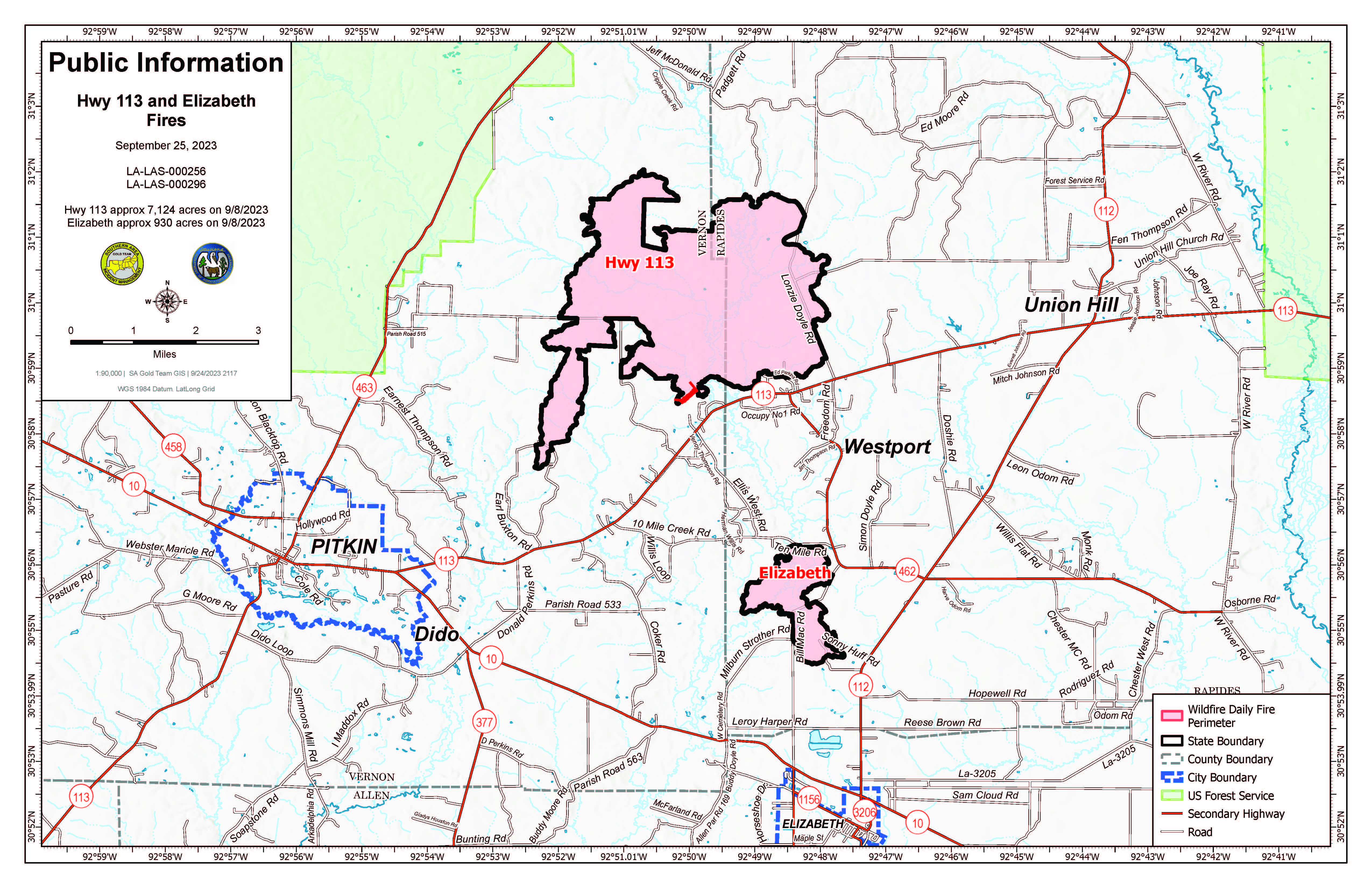
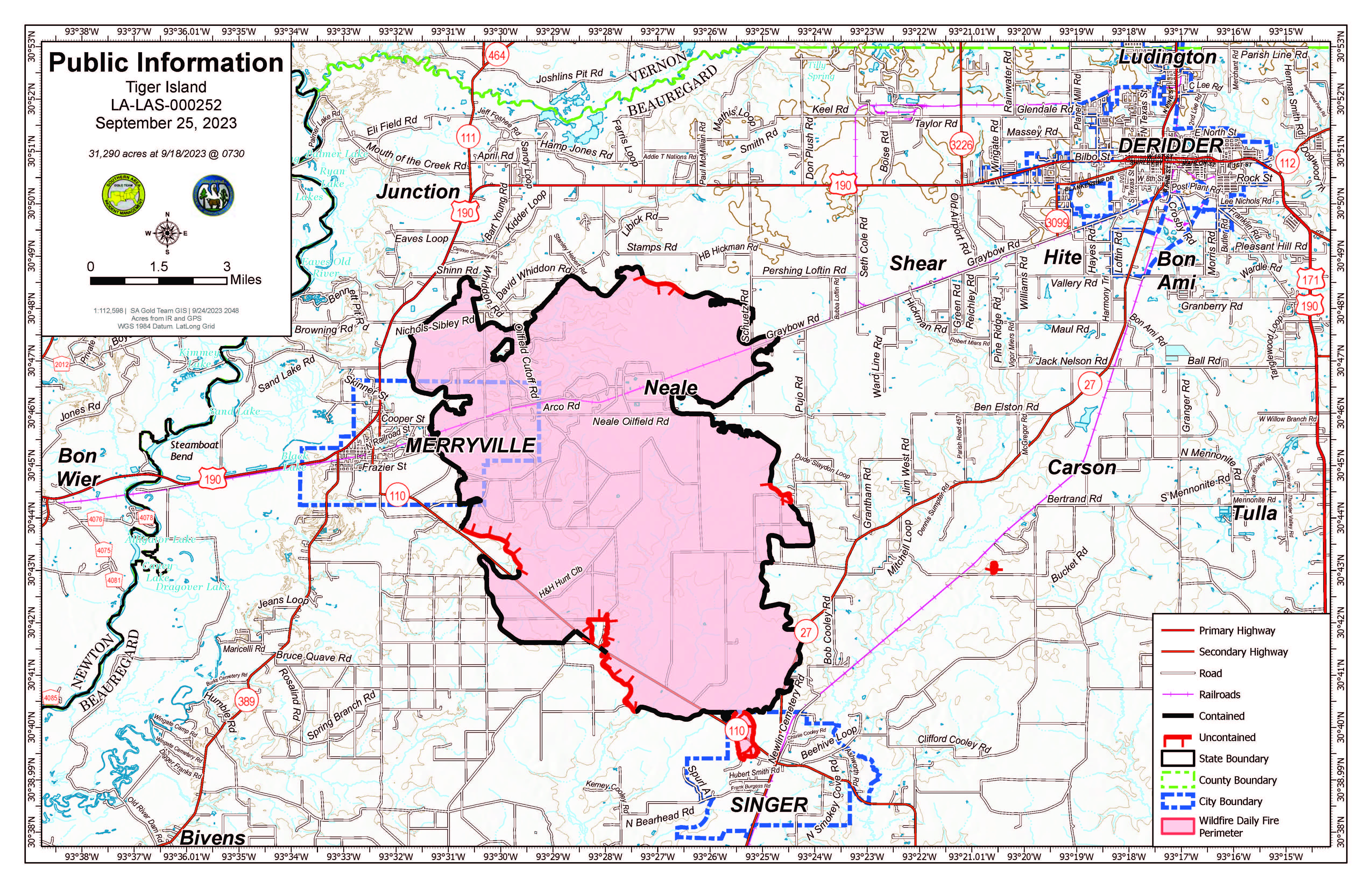
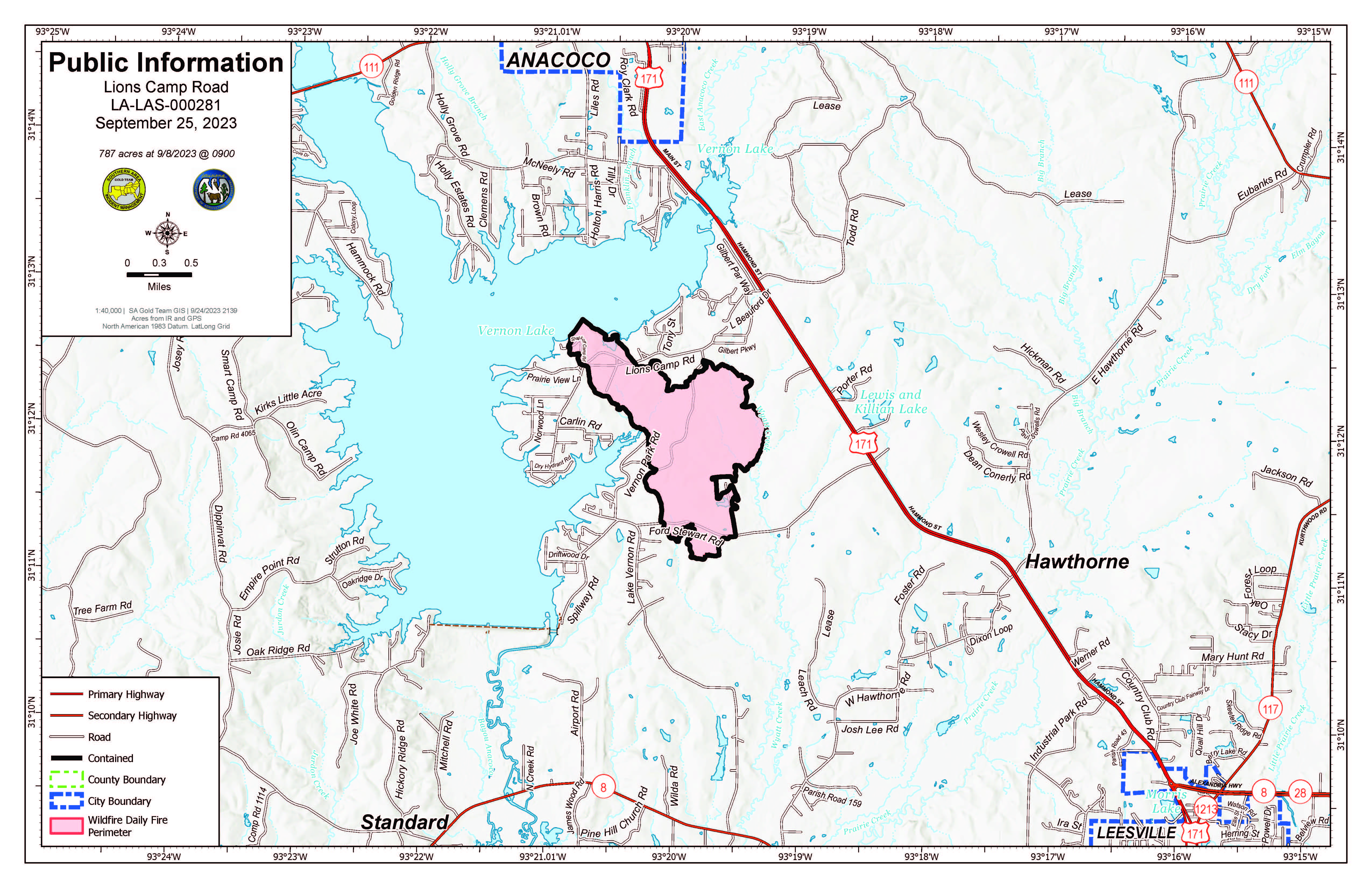
Yesterday, crews continued to mop up, patrol and break apart hot debris piles along Vernon Park Road. On the Tiger Island Fire, firefighters sought out heat signatures identified on the infrared flight and mopped them up. On the Hwy. 113 and Elizabeth Fires, crews also looked for hot spots in the 10-Mile Creek drainage identified by the infrared flight and mopped those up where possible.
Overnight, all four fires received trace amounts of rainfall. Today, as weather allows, crews will seek out and mop up hot spots; patrol and hold containment lines; clean out needle cast; and create more depth inside the fires’ perimeters.
- Tiger Island Fire: 31,290 acres, no change | 84% contained| 224 personnel assigned InciWeb: https://inciweb.nwcg.gov/incident-information/lalas-tiger-island-fire
- Hwy. 113 Fire: 7,124 acres, no change | 95% contained | 35 personnel assigned InciWeb: https://inciweb.nwcg.gov/incident-information/lalas-hwy-113-fire
- Lions Camp Road Fire: 785 acres, no change | 100% contained | 1 person assigned InciWeb: https://inciweb.nwcg.gov/incident-information/lalas-lions-camp-road-fire
- Elizabeth Fire: 940 acres, no change | 100% contained | 21 personnel assigned InciWeb: https://inciweb.nwcg.gov/incident-information/lalas-elizabeth-fire
Equipment
Type 6 engines, dozers, tractor plow units, water tenders, medical squads and ambulances are assigned to the fires. Aerial resources including helicopters and fixed-wing aircraft also are available. Parish authorities and departments, sheriff’s offices, and the Governor’s Office of Homeland Security and Emergency Preparedness are providing additional support.
Weather and Fire Behavior
A front approaching from the northwest will bring the potential for afternoon pop-up showers and thunderstorms over the region. Some of the showers and storms may bring potential heavy rainfall, lightning and gusty winds with a marginal risk for flash flooding and strong to severe thunderstorms. Any rainfall will not be enough to erase the current drought conditions. The rainfall and cloud cover Monday will again keep temperatures slightly cooler and limit humidity from falling below 60%. Additional showers and storms are possible Tuesday through Thursday as the front is slow to push through the state and out over the Gulf of Mexico. Toward the end of the week, mostly sunny skies, lower humidity and afternoon wind gusts will likely bring back elevated fire weather.
Fire behavior is expected to decrease temporarily with increased humidity, cloud cover and lower temperatures. Minor smoldering is possible on the Tiger Island, Hwy. 113 and Elizabeth Fires. Lightning from thunderstorms brings an outside chance for new fire starts.
Air Quality
Smoke may occur in reburn areas. Air quality information is available at https://fire.airnow.gov.
Temporary Flight Restrictions (TFRs)
TFRs remain in place over the Tiger Island Fire (https://tfr.faa.gov/save_pages/detail_3_3911.html). A smaller, new TFR is in place for the Hwy. 113 and Elizabeth Fires https://tfr.faa.gov/save_pages/detail_3_4065.html). Remember: If you fly, we can’t.