
Single Publication
Red Rock and Black Eagle Fire Incident Update 09-13-2024
Publication Type: News - 09/13/2024 - 09:00
Additional resources have been ordered to assist in the management and containment of both Red Rock and Black Eagle fires, as firefighting forces attempt to use yesterday’s favorable weather conditions to make progress on fire containment.
Red Rock:
Fire acreage remains at 2570 acres with 0% containment. Yesterday, crews looked for opportunities to directly and indirectly engage the fire along its perimeter. Today, crews plan to construct a handline from Road 60110 North and East along the fire’s edge. Heavy equipment will used to improve access and expand fire control features along Road 60214, as well as on Road 60210 going west from roadway 60055.
Incident personnel continued structure protection activities along the Panther Creek Corridor up to the Ranger Station, and will extend those efforts north of Moyer.
Black Eagle:
Fire acreage remains at 5914 acres with 0% containment. On the north side of the fire, resources continue structure protection activities, implementing protective measures - sprinklers, hose, and pumps - at Yellowjacket and Bighorn Crags campsites, as well as Black Eagle Mine. Along the western boundary, resources continue to monitor conditions and look for opportunities to engage the fire.
Weather and Fire Behavior:
Yesterday a wetting rain blanketed the fire footprint, with snow seen in higher elevations. Today we can expect drier conditions, with temperatures in the 50’s over the fire area and relative humidity around 30%. Winds are expected at 5-10 mph out of the west, with gusts up to 20 mph along ridgetops.
Yesterday’s precipitation and nearly 20 hours of high humidity allowed much of the fuel load to absorb moisture and suppressed fire activity. Heavy dead and downed fuel are likely to retained heat despite the precipitation, and may continue to produce smoke. As the weather warms over the coming days, grasses and other small fuels quick to shed yesterday’s moisture will be the most likely areas of potential fire spread.
FOREST CLOSURE:
NFS lands, roads and trails on the Salmon‐Cobalt, and North Fork Ranger Districts of the Salmon‐Challis National Forest within the area bounded by the following:
Beginning at the intersection of Blackbird creek with Panther Creek, following Blackbird creek to Blackbird mountain, then following FS Road 33 to the Frank Church River of No Return Wilderness boundary, and following the boundary to the Golden Trout Lake Trailhead, including the Big Horn Crags Campground and crossing over into the Frank Church River of No Return Wilderness and onto the ridge to the west of Wilson Creek, then going south to Middle Fork Peak. From Middle Fork Peak to the Frank Church River of No Return Wilderness Boundary to trail 053 then running along Little Jacket Creek to Trail 051, then following Trail 051 to Birdseye Creek to Forest Road 245 at its intersection with Panther Creek Road 55, then following the western side of Panther Creek Road until it reaches Blackbird Creek.
- Additionally, the McDonald Creek Campground and all associated roads are closed.
For the latest information on area closures, please contact the North Fork Ranger District at (208) 865-2700.Details on the Black Eagle Fire can also be found on InciWeb: https://inciweb.wildfire.gov/incident-information/idscf-black-eagle-fire.
The forest is asking visitors to be aware of the fire danger for the Salmon-Challis National Forest. Ensure your campfire is dead out. If it is too hot to touch, it is too hot to leave! One Less Spark Means One Less Wildfire. Since June 1, Forest employees have found and extinguished at least 13 abandoned campfires.
EVACUATIONS:
Lemhi County: Evacuation order and warnings remain in effect. For more information, please go to: https://www.lemhicountyidaho.org/site-home/news/black-eagle-and-red-rock-fire-update
SMOKE REPORT:
For more information about drift and air quality, go to AirNow.gov https://outlooks.airfire.org/outlook/d60d6285.
Visit our website at: www.fs.usda.gov/scnf/, ‘Like Us’ on Facebook @salmonchallisnf, and ‘Follow Us’ on X @salmonchallisnf.
####
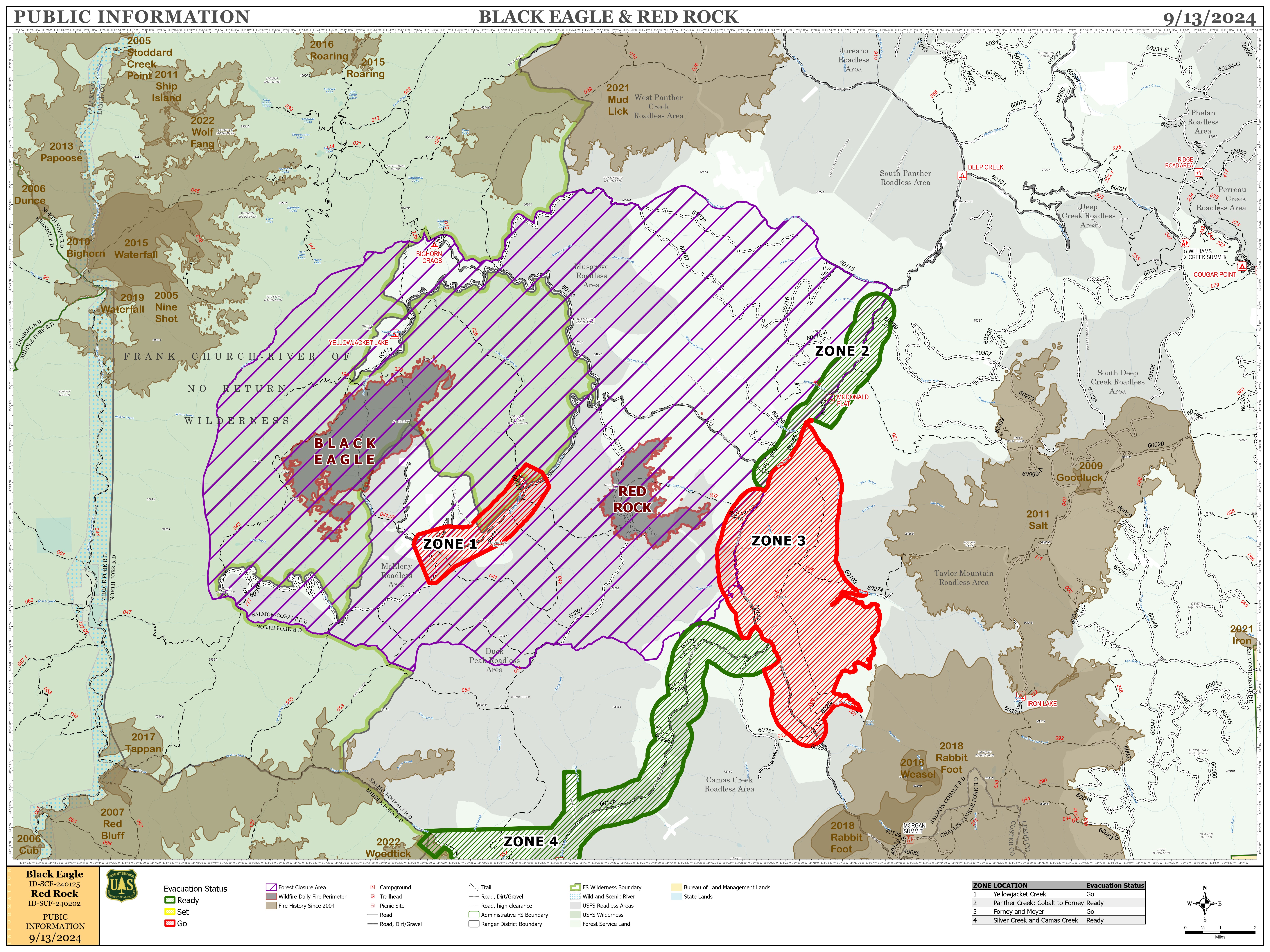
Map showing the fires in the forest