
Single Publication
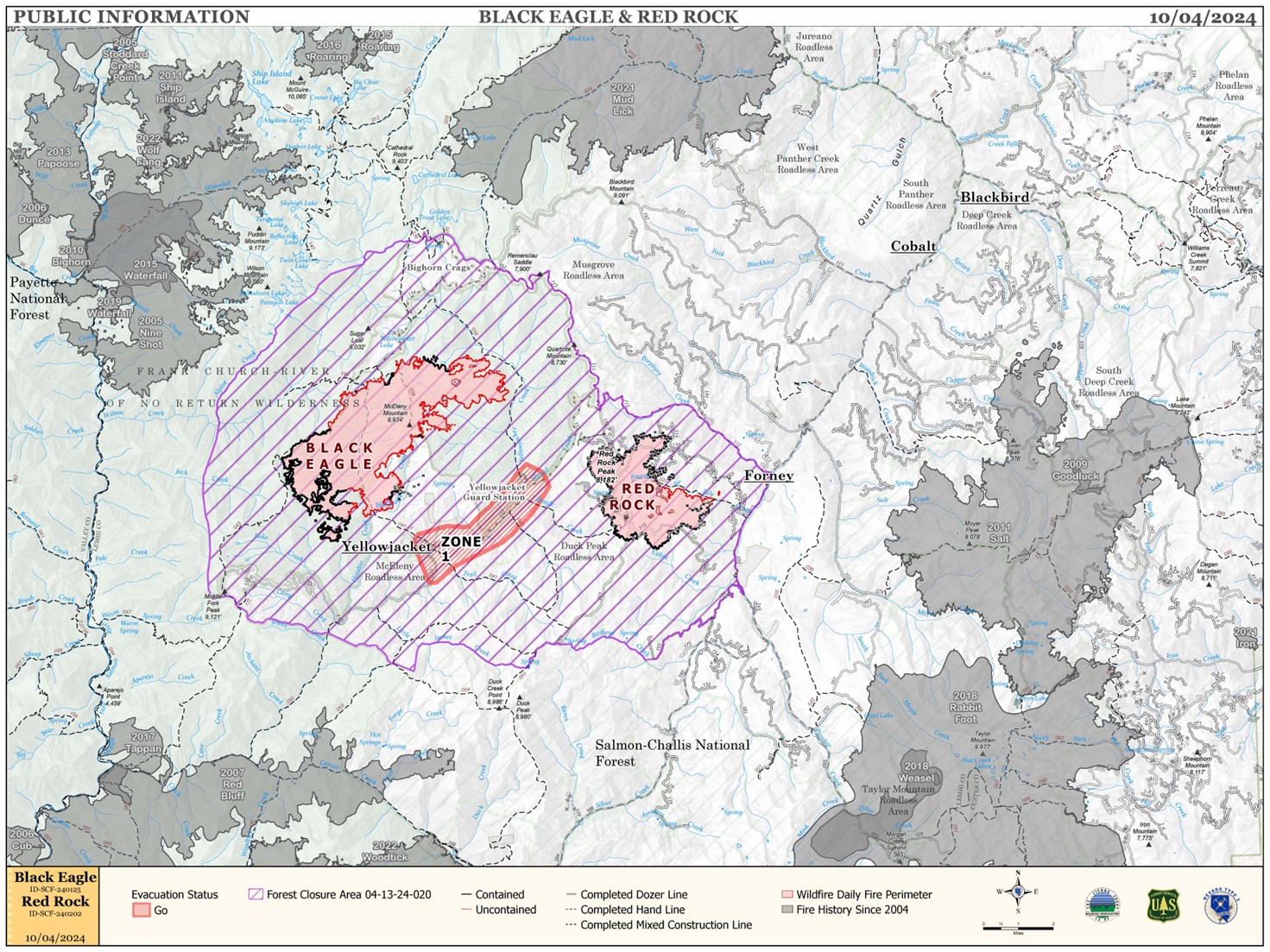
Red Rock and Black Eagle Fire Daily Update 10-04-2024
Publication Type: News - 10/04/2024 - 08:53
RED FLAG WARNING ISSUED FOR RED ROCK AND BLACK EAGLE FIRE AREAS
WEATHER:
A Red Flag Warning for strong winds and low humidity is in effect for Friday between 12:00 p.m. and 9:00 p.m. Strong west to southwest winds 20-23 mph with gusts 40-50 mph are forecasted. Humidity will dip into the teens as a strong but dry cold front moves through the area Friday afternoon and evening. This front is not tapping into a large moisture source, so while humidity will go up Friday night, little to no rain is expected. The predicted weather will create an active fire environment in west to east drainages and in heavy dead and down fuels.
FIRE ACTIVITY:
The Red Rock Fire is at 3,576 acres and 78% containment.
Crews were successful in bringing the fire down to the Fourth of July Creek, but today backing fire will test the burnout operations in the area. The heat generated from heavy dead and down fuels will induce single and group tree torching, short range spotting, and short fire runs when alignments with slope or wind occur. Crews continue to monitor the control line, backhaul equipment, and work on suppression repair on the northwest, west, and south sides of the fire.
The Black Eagle Fire is at 7,936 acres and 16% containment.
Good overnight humidity recovery and cooler morning temperatures moderated fire activity on Thursday. As humidity dipped into the teens in the afternoon, and fuels were exposed to sunlight and west-southwest winds, the fire environment became more active, primarily in wilderness. Crews worked on structure preparation and sprinklers yesterday in the Yellowjacket area ahead of today’s wind event. Crews are also working in the Blackeagle Creek area, where fire behavior has increased and the fire is backing down to the creek.
FIRE BEHAVIOR:
Nearly all fuels are available across both fires, though heavy dead and down fuels remain most problematic for firefighters. Areas where humidities fall below 25% with gusty afternoon winds can experience increased activity, including short-range spotting. Opportunities to attack the fire directly will likely be confined to morning hours and when effective water support is available.
FOREST CLOSURES: For forest closure information please go to: https://www.fs.usda.gov/alerts/scnf/alerts-notices
EVACUATIONS: For evacuation information in Lemhi County regarding these fires please go to: Emergency Management Department | Lemhi County, ID (lemhicountyidaho.org).