
Single Publication
Daily Update 09-28-24 09-28-2024
Publication Type: News - 09/28/2024 - 10:08
Current Situation:
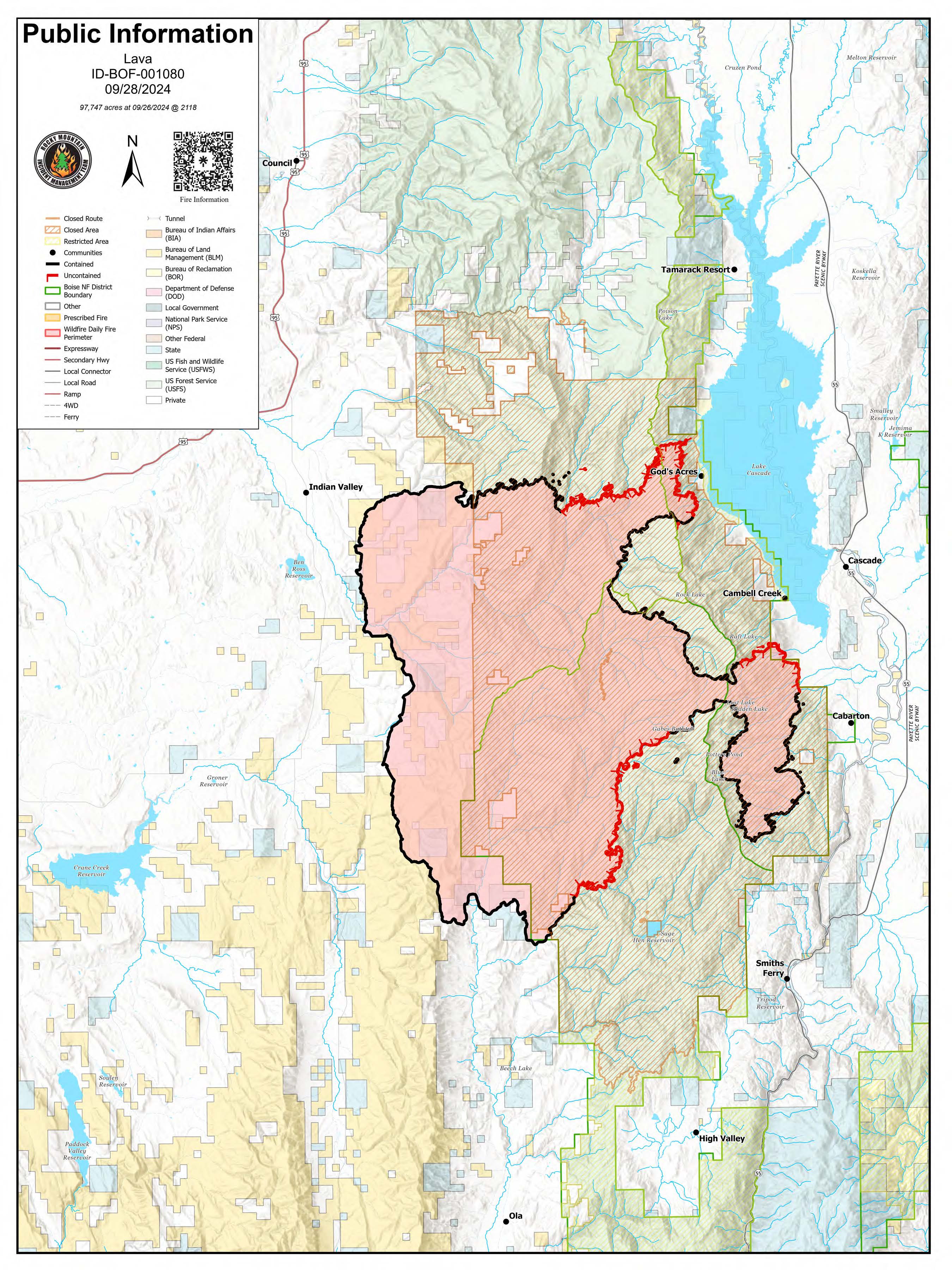
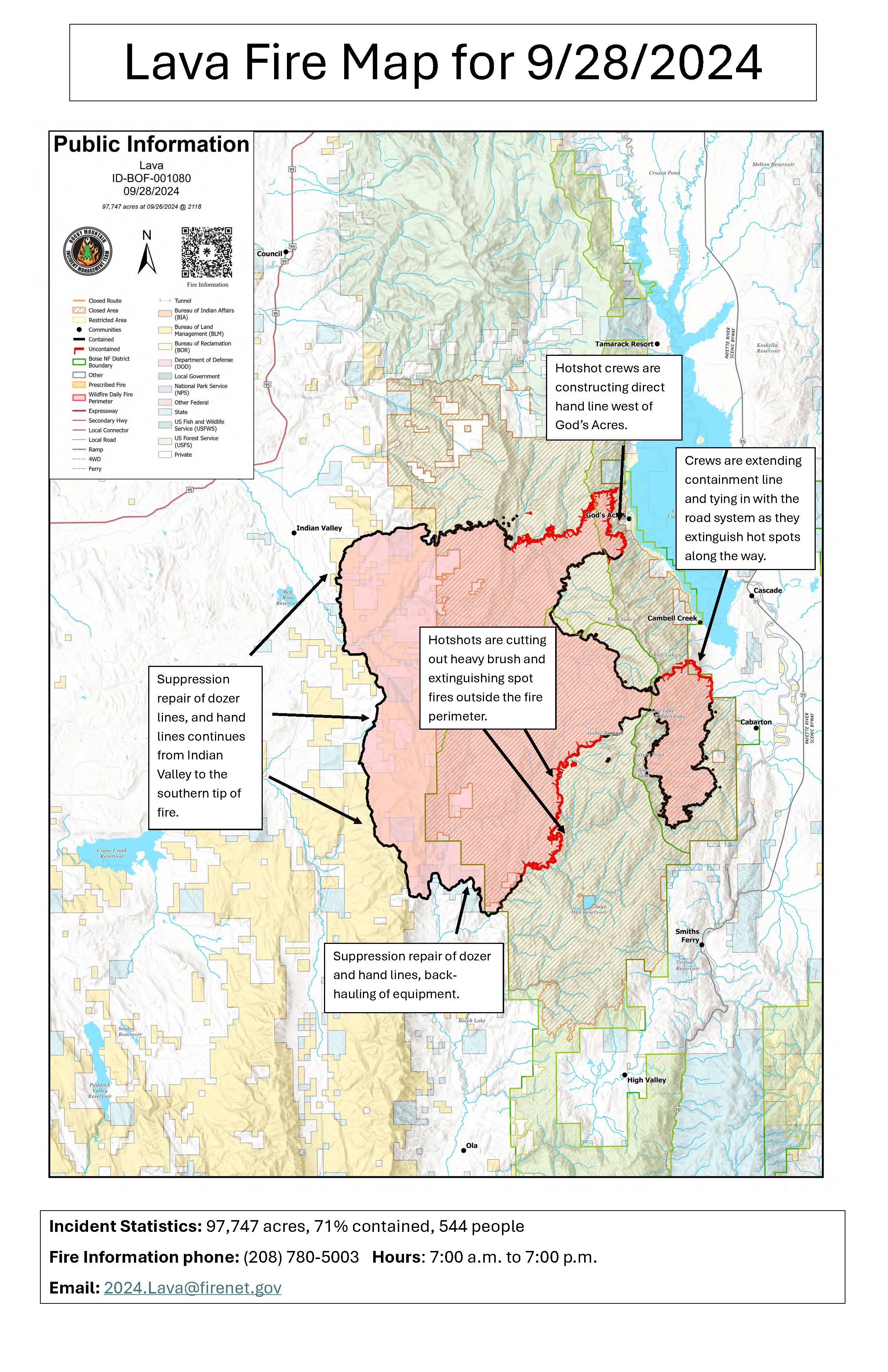
- The Lava Fire is 71% contained at 97,747 acres, with 544 personnel assigned.
- On the east side of the fire, Idaho City Hotshots constructed hand line from Snowbank Mountain to Gabes Peak. Smokes were visible in the area. Helicopters delivered 55,000 gallons of water to firefighters there. Work here is expected to take several days to contain the fire’s edge.
- The Kern Hotshots scouted southeast fire’s edge south of Gabes Peak to the Second Fork of Squaw Creek yesterday along the 653 Road. They will work on cutting brush and extinguishing hot spots along the fire edge to secure the line.
- Hotshot crews will be constructing handline directly along the fire’s perimeter west of God’s Acre.
- The spot fires discovered outside the fire’s northeast perimeter were controlled yesterday.
- As containment is established, crews are repairing damage from suppression activities and are back hauling the equipment that is no longer needed.
Weather: Warmer weather was prevalent over the fire area yesterday and today’s weather is expected to be somewhat warmer and dryer today, with possibly record setting temperatures on Saturday.
Evacuations: A Level 1 “READY” notice remains for residents south of South Grays Creek, along Little Weiser River Road in Indian Valley, North of South Grays Creek Road to Highway 95, and the Mesa Area. Valley County Sheriff’s Office has removed Zones 2 & 3 from LEVEL 1 “READY” status. Zones 4 – 6 remain in a LEVEL 1 “READY” Evacuation notice.
Closures: Closures: The Boise and Payette National Forests implemented a joint Lava Fire Area, Road, and Trail Closure for public and firefighter safety. For more closure information see the Payette National Forest website: https://www.fs.usda.gov/alerts/payette/alerts-notices or the Boise National Forest website: https://www.fs.usda.gov/alerts/boise/alerts-notices.
Gem County Road and Bridge issued the following road closures: Third Fork Road at Nesbitt Lane, Second Fork Road at Nesbitt Lane, and Nesbitt Lane. The Sweet-Ola Highway is closed at the High Valley intersection in Ola.
Temporary Flight Restrictions: A temporary flight restriction (TFR) has been updated. View a map of the TFR and details at https://tfr.faa.gov/save_pages/detail_4_8199.html. Fire aviation response is halted or delayed if an unauthorized aircraft enters the TFR. Temporary flight restrictions also apply to unmanned aircraft systems or drones. If you fly, we can’t! Learn more about how to use drones safely and responsibly at Home - Know Before You Fly.
Fire Info Phone: 208-708-5003 Hours: 7:00 a.m. to 7:00 p.m. Email: 2024.Lava@firenet.gov .
Facebook:@LavaFire Inciweb: inciweb.wildfire.gov/incident-information/idbof-lava-fire