
Single Publication
Could not determine your location.
 Wildfire
 Prescribed Fire
 Burned Area
Response
Burned Area
Response Other
Other
Daily Update for the Sand Stone Fire 07-29-2024
Sand Stone
Publication Type: News - 07/29/2024 - 10:12
Southwest Area Complex Incident Management Team 4 assumes command of the
Sand Stone, Deer, and Davenport Fires
Daily Update – Monday, July 29, 2024
Highlights: The Southwest Area Complex Incident Management Team 4 assumed command of the Sand Stone, Deer, and Davenport Fires at 6:00 am this morning, Monday, July 29, 2024. A complex team brings additional resources and management capabilities to manage these incidents. Incident objectives include protecting values at risk, including adjacent Tribal and private lands, power and transportation infrastructure, cultural and natural resources including the Sonoran Desert ecosystem and Mazatzal Wilderness, threatened and endangered species, and range improvements.
Total personnel on all incidents: 200
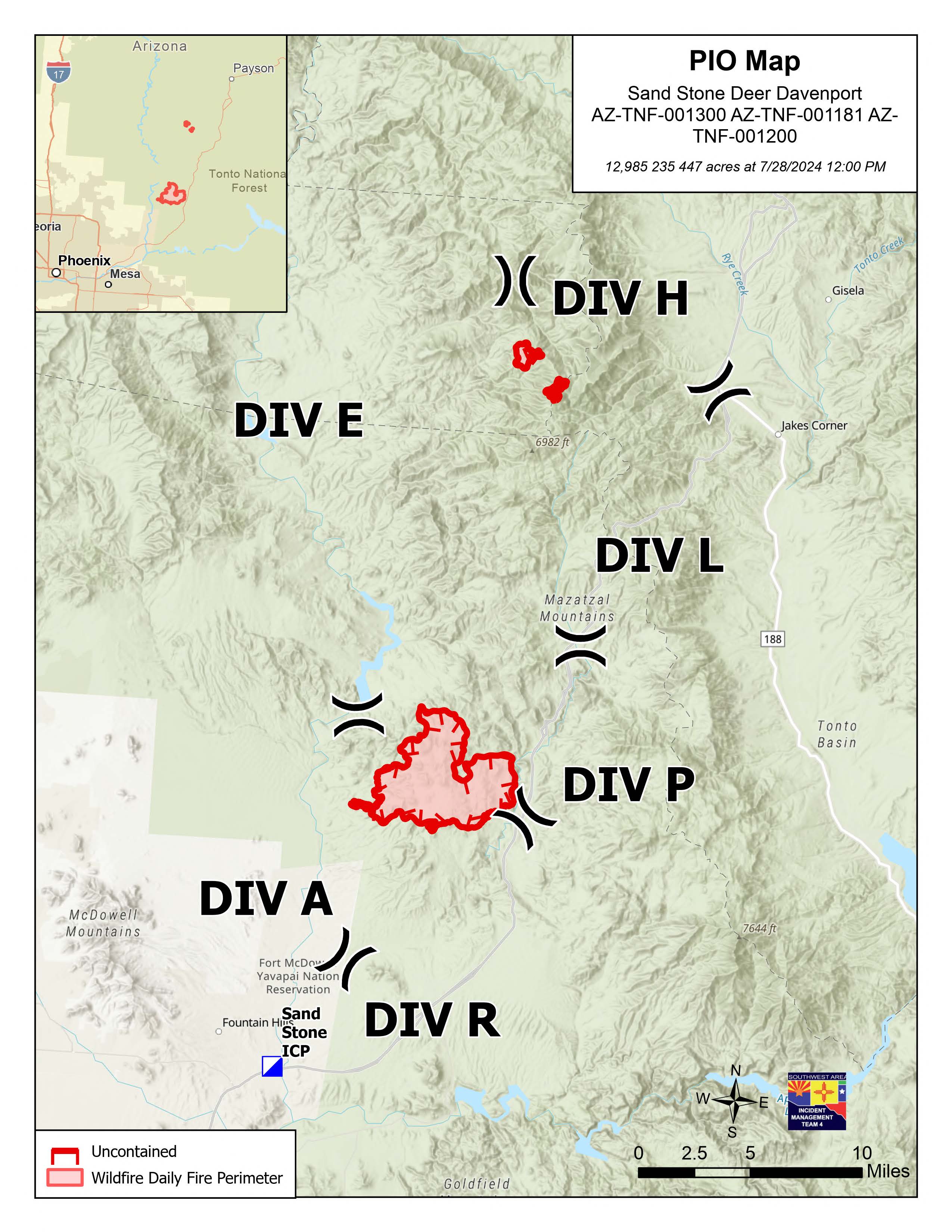
Sand Stone Fire: Acres: 12,985 Containment: 0% Start Date: 7/25/2024 Fuels: Grass, brush
Operations: Yesterday, fire crews strategically ignited fuels around the Dos S Ranch and used a bulldozer to build dozerline around the community of Sunflower, removing vegetation ahead of the main fire as a measure to protect values at risk. Fire crews worked along the Arizona National Scenic Trail to provide additional protection against fire spread to the east. Today, crews will assess additional needs for point protection around the Sunflower area and plan to conduct a strategic firing operation along the old Highway 87 to prevent fire spread to the east of the highway. Additional personnel will look for secondary fire line opportunities to limit fire spread to the south and west to minimize effects to Tribal land and nearby communities.
Deer Fire: Acres: 235 Containment: 0% Start Date: 7/17/2024 Fuels: Grass, brush, timber
Operations: The Deer Fire is burning within the Mazatzal Wilderness. Activity increased slightly yesterday, leading to low severity impacts on the landscape. Firefighters observed the fire slowly backing downhill with low flames, consuming grasses and vegetation along the ground.
Davenport Fire: Acres: 447 Containment: 0% Start Date: 7/19/2024 Fuels: Grass, brush
Operations: The Davenport Fire was reported within the Mazatzal Wilderness and has not shown any fire activity for several days. Firefighters are continuing to monitor fire activity for any new heat sources or growth.
Weather: Temperatures on the Sand Stone Fire will be just under 100°F today, with relative humidity levels near 20%. The Deer Fire will be about 10 degrees cooler. Chance of thunderstorms remains low.
Smoke: Smoke may be visible from Fountain Hills, Sunflower, Rio Verde, Goldfield, and unincorporated communities in the Rio Verde Foothills. An interactive smoke map at https://fire.airnow.gov/ allows you to zoom into your area to see the latest smoke conditions.
Closures: Southbound State Route 87 is closed between State Route 188 to Bush Highway. There is no estimated time to reopen the southbound lanes. See https://az511.gov/ for a map of the closure. A Tonto National Forest closure order for the Sand Stone Fire is anticipated in the near future. Trail users should avoid using the Arizona National Scenic Trail near the fire area. Residents can sign up for emergency alerts at ready.maricopa.gov.
Safety: The health and safety of firefighters and the public are always the first priority. A temporary flight restriction (TFR) is in place over the area, which includes uncrewed aircraft or drones. Flying drones near wildfires is dangerous for pilots and firefighters and can bring wildfire suppression efforts to a halt. Know before you fly. If you fly, we can’t. More information on the dangers drones pose to wildland firefighting aircraft and personnel on the ground can be found at: https://uas.nifc.gov/.
More Information: https://inciweb.wildfire.gov/incident-information/aztnf-sand-stone /
480-409-9683 / https://www.facebook.com/TontoNationalForest / 2024.sandstone@firenet.gov