Single Publication
Could not determine your location.
 Wildfire
 Prescribed Fire
 Burned Area
Response
Burned Area
Response Other
Other
Grapefruit Complex
Unit Information

Incident Contacts
July 1 Grapefruit Complex Daily Update 07-01-2024
Grapefruit Complex
Publication Type: News - 07/01/2024 - 11:30
Grapefruit Complex Update, July 1 ,2024
Alaska Incident Management Team 3
Incident Commander- Peter Butteri
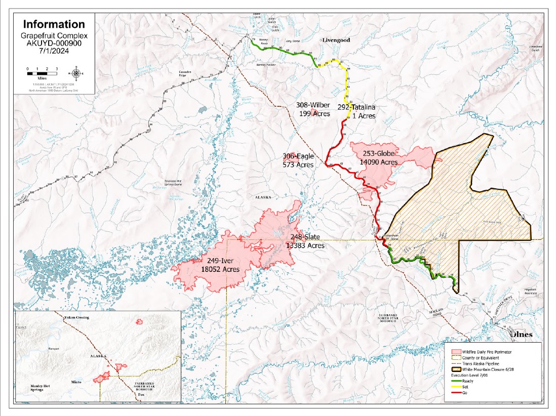
Location: 40 Miles north of Fairbanks Complex Acres: 55,411
Personnel: 140 Containment: 0%
An Alaska Complex Incident Management team took command of the Grapefruit Complex of six fires burning along the Elliott Highway south of Livengood.
Most of the fires have grown under the hot and dry conditions with predicted wind in the area, more growth is expected. There’s a chance of cooler, moist weather moving into the area starting on Wednesday. While change in weather will bring moisture, there are predicted weather events that will promote extreme fire behavior before the rains are expected. Expect significant delays on the highway due to an increase of fire activity today and predicted weather events throughout the week.
The Globe Fire (#253), which was estimated at 12,526 acres, was burning in a mostly easterly direction and farther into the White Mountains.
The Iver Fire (#249) is estimated at 27,211 acres is expected to grow more to the east today that has a potential to bring the active fires edge closer to the Elliott Highway, the neighborhoods along the highway corridor and the Globe Fire. The Trans-Alaska Pipeline lies between the two fires, with the Iver Fire about 7 miles southwest of where the Globe Fire it crossed the highway at mile 39.
Crews will continue setting up sprinkler systems and work on structure protection along the Elliott Highway corridor closest to the fires well as scouting for any other values at risk in the area. A dozer line was constructed around a small subdivision on the west side of the highway near 40 mile. A fire break was being constructed around two of the three Native allotments near the fire. Firefighters will continue to brush out this line, fortify fire breaks, and set up sprinkler systems to wet down properties near the fire. A night shift has also been established to patrol neighborhoods and the highway corridor during the nighttime hours.
Smoke: Smoke will continue throughout the surrounding communities with wind shifts throughout the day and the smoke also may hamper aerial support for firefighters on the ground.
The complex also includes:
- The Eagle Fire (#306) is estimated at 118 acres. It wasn’t immediately threatening any known sites of value. This lightning-caused fire has been burning since late Friday night and has shown significant growth in the past few days.
- The Wilber Fire (#308) was reported at about 2 p.m. Saturday. It is about 4 miles west of mile 51 and estimated at 77 acres. This fire was showing significant activity in the afternoon and acreage growth is expected.
- The Noordor Fire (#192) is estimated at 9,068 acres. This lightning-caused fire has been burning on BLM-managed land since June 20.
- The Fossil Fire (#115) is not exhibiting any fire activity or smoke but will still be grouped into the complex. It is located in the White Mountains National Recreation Area.
Evacuation: A GO Evacuation Order is still in place for people within mileposts 39-48 of the Elliott Highway.
Road access: The section of the Elliott Highway near the Globe Fire is open. Expect significant delays between mileposts 25-50 if fire activity increases. Please exercise caution and patience, turn on your headlights to help ensure the safety of firefighters and flaggers working in the area. Alaska Department of Transportation & Public Facilities contracted workers and a pilot car are helping keep the flow of traffic open. Check https://511.alaska.gov/ for road updates.
Temporary Flight Restriction: A TFR is in place during the day to provide a safe environment for firefighting aircraft.
Closures: The Bureau of Land Management (BLM) Eastern Interior Field Office closedthe western portion of the White Mountains National Recreation Area surrounding the Wickersham Dome Trailhead at mile 28 Elliott Highway. The closure is in effect until Sept. 1, unless the BLM determines the area is safe for public use at an earlier time.
Fire Information Public Phone: 907-615-6793 Inciweb: tinyurl.com/grapefruitcomplexfireinciweb
Facebook: www.facebook.com/BLMAFS Twitter: twitter.com/BLM_AFS