Incident Media Maps
Could not determine your location.
 Wildfire
 Prescribed Fire
 Burned Area
Response
Burned Area
Response Other
Other
Flat Fire
Unit Information
Agency Name: U.S. Forest Service
Agency Name: U.S. Forest Service
Incident Contacts
- Liv Stecker - Fire InformationEmail:Phone:541.646.9177Hours:8 am - 5 pm
Maps Gallery

View Smoke Outlook
Fire
Showers on the western portion of the fire will limit fire behavior. Continued smoldering will be the primary fire activity and isolated to areas of sheltered fuels, snags, and stumps. No additional perimeter growth is expected at this time. Windy conditions for Saturday, with warmer and drier weather building in may increase fire behavior by midweek next week.
Smoke
Overall, GOOD air quality continues throughout the forecast area. Ongoing showers Friday will limited any new smoke production. Areas of heaviest smoke impacts will be in low-lying drainages in the immediate vicinity of the fire. Valleys along the Elk and Sixes River, as well as tributaries, will see residual smoke from smoldering. Watch out conditions for smoke on roadways where valleys and drainages meet HWY 101 - primarily from Humbug Mountain State Park northward to Langlois. Gusty winds on Saturday will limit smoke accumulation. Sunday into next week, drier conditions will promote ongoing smoldering and increase the potential for new smoke production. If fire activity increases with drier conditions, smoke will build along these valleys and begin impacting communities further from the fire perimeter.
---
Incéndio
Las lluvias ligeras aisladas limitarán la actividad de fuego. La combustión lenta persistirá donde haya calor. Las lluvias y los vientos tarde el jueves y el viernes traerán humedad sobre el incendio. Los vientos se intensificarán el viernes al anochecer y durante la noche hasta el sábado. No se espera una propagación significativa del incendio debido las condiciones del tiempo recientes; sin embargo, si comienza una tendencia de calentamiento y sequedad a principios de la próxima semana, es probable que aumente la actividad de fuego. Las operaciones tácticas continuarán aumentando la contención y asegurando el área afectada por el incendio.
Humo
En general, la calidad del aire es BUENA en toda el área de pronóstico. Se esperan períodos intermitentes de condiciones MODERADAS a INSALUBRES PARA GRUPOS SENSIBLES en áreas donde se anticipa humo residual en el drenaje durante la noche. A lo largo de la carretera HWY 101 desde el Parque Estatal Humbug hacia el norte hasta la Línea del Condado de Coos-Curry, es posible que haya humo intermitente. Combinado con la niebla, es probable que haya una visibilidad limitada en la carretera durante horas de la noche. Los impactos de humo más fuertes se darán en áreas bajas a lo largo de los drenajes de los ríos Elk y Sixes. La precipitación entrante y los vientos fuertes desde el jueves por la noche hasta el viernes limitarán la producción y acumulación de humo adicional. Para el fin de semana, los vientos ligeros y las condiciones más secas promoverán la combustión lenta y fuego de arrastre dentro del incendio, permitiendo que el humo se acumule en áreas más abajo de cualquier calor activo.
Fire
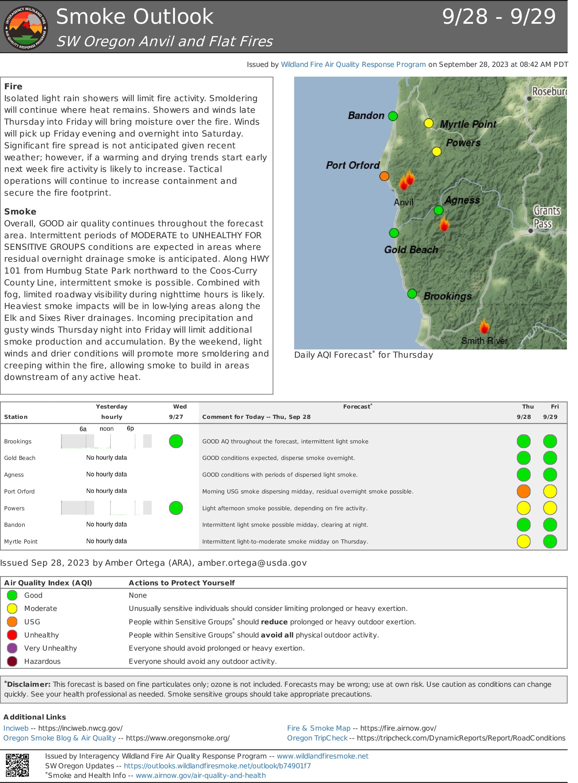
Isolated light rain showers will limit fire activity. Smoldering will continue where heat remains. Showers and winds late Thursday into Friday will bring moisture over the fire. Winds will pick up Friday evening and overnight into Saturday. Significant fire spread is not anticipated given recent weather; however, if a warming and drying trends start early next week fire activity is likely to increase. Tactical operations will continue to increase containment and secure the fire footprint.
Smoke
Overall, GOOD air quality continues throughout the forecast area. Intermittent periods of MODERATE to UNHEALTHY FOR SENSITIVE GROUPS conditions are expected in areas where residual overnight drainage smoke is anticipated. Along HWY 101 from Humbug State Park northward to the Coos-Curry County Line, intermittent smoke is possible. Combined with fog, limited roadway visibility during nighttime hours is likely. Heaviest smoke impacts will be in low-lying areas along the Elk and Sixes River drainages. Incoming precipitation and gusty winds Thursday night into Friday will limit additional smoke production and accumulation. By the weekend, light winds and drier conditions will promote more smoldering and creeping within the fire, allowing smoke to build in areas downstream of any active heat.
---
Incéndio
El calor aislado permanece en el interior del Incendio Anvil. Las lluvias continuas después de una precipitación significativa han limitado la propagación del fuego y el nuevo crecimiento. Es posible que haya lluvias ligeras aisladas hoy hasta el jueves. El secado mínimo de los combustibles continuará reduciendo el comportamiento del fuego. El fuego seguirá ardiendo lentamente dentro del perímetro del incendio.
Humo
Después de una lluvia prolongada y continua, la calidad del aire sigue siendo BUENA en el área de pronóstico. El humo residual se acumulará y fluirá hacia abajo en los drenajes desde cualquier calor remanente de combustión lenta dentro del perímetro del incendio. Las ubicaciones dentro de los drenajes de Sixes y Elk River experimentarán impactos de humo ligero a moderado. La niebla mezclada con humo ligero afectará a la carretera HWY 101 desde Gold Beach hasta Bandon, concentrándose en ubicaciones donde el terreno permite que el humo de la combustión lenta se acumule y fluya hacia abajo por los drenajes. Las comunidades en las inmediaciones del incendio experimentarán impactos intermitentes de humo. A medida que las condiciones más secas se vayan estableciendo lentamente hasta el jueves, es posible una nueva producción de humo. Este fin de semana trae otra amenaza de lluvia; para la próxima semana, cuando comience una tendencia de calentamiento y secado, es posible que haya un humo significativo si la actividad del fuego aumenta.
Fire
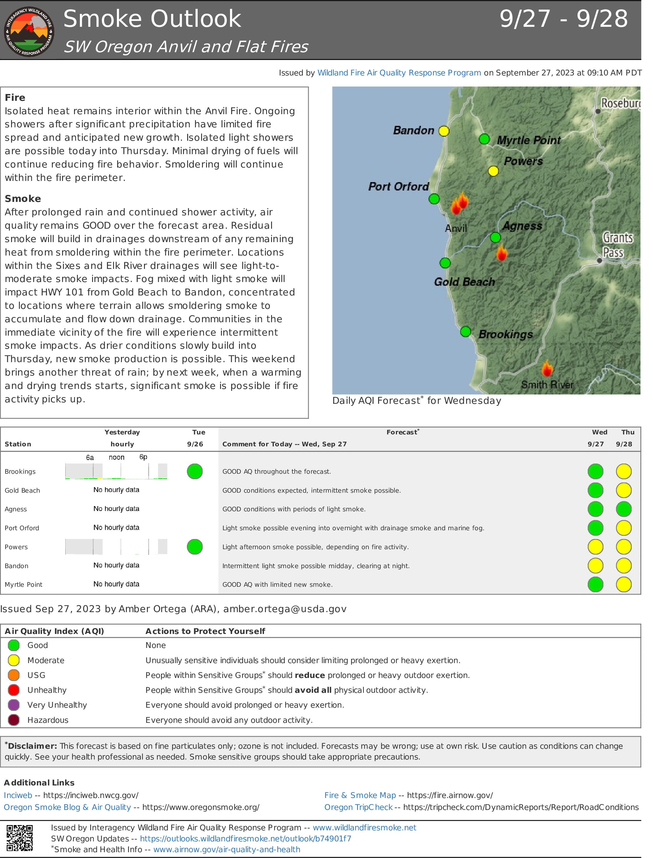
Isolated heat remains interior within the Anvil Fire. Ongoing showers after significant precipitation have limited fire spread and anticipated new growth. Isolated light showers are possible today into Thursday. Minimal drying of fuels will continue reducing fire behavior. Smoldering will continue within the fire perimeter.
Smoke
After prolonged rain and continued shower activity, air quality remains GOOD over the forecast area. Residual smoke will build in drainages downstream of any remaining heat from smoldering within the fire perimeter. Locations within the Sixes and Elk River drainages will see light-to-moderate smoke impacts. Fog mixed with light smoke will impact HWY 101 from Gold Beach to Bandon, concentrated to locations where terrain allows smoldering smoke to accumulate and flow down drainage. Communities in the immediate vicinity of the fire will experience intermittent smoke impacts. As drier conditions slowly build into Thursday, new smoke production is possible. This weekend brings another threat of rain; by next week, when a warming and drying trends starts, significant smoke is possible if fire activity picks up.
--
Incéndio
El calor aislado permanece en el interior del Incendio Anvil. Las lluvias continuas después de una precipitación significativa han limitado la propagación del fuego y el nuevo crecimiento. Es posible que haya lluvias ligeras aisladas hoy hasta el jueves. El secado mínimo de los combustibles continuará reduciendo el comportamiento del fuego. El fuego seguirá ardiendo lentamente dentro del perímetro del incendio.
Humo
Después de una lluvia prolongada y continua, la calidad del aire sigue siendo BUENA en el área de pronóstico. El humo residual se acumulará y fluirá hacia abajo en los drenajes desde cualquier calor remanente de combustión lenta dentro del perímetro del incendio. Las ubicaciones dentro de los drenajes de Sixes y Elk River experimentarán impactos de humo ligero a moderado. La niebla mezclada con humo ligero afectará a la carretera HWY 101 desde Gold Beach hasta Bandon, concentrándose en ubicaciones donde el terreno permite que el humo de la combustión lenta se acumule y fluya hacia abajo por los drenajes. Las comunidades en las inmediaciones del incendio experimentarán impactos intermitentes de humo. A medida que las condiciones más secas se vayan estableciendo lentamente hasta el jueves, es posible una nueva producción de humo. Este fin de semana trae otra amenaza de lluvia; para la próxima semana, cuando comience una tendencia de calentamiento y secado, es posible que haya un humo significativo si la actividad del fuego aumenta.