
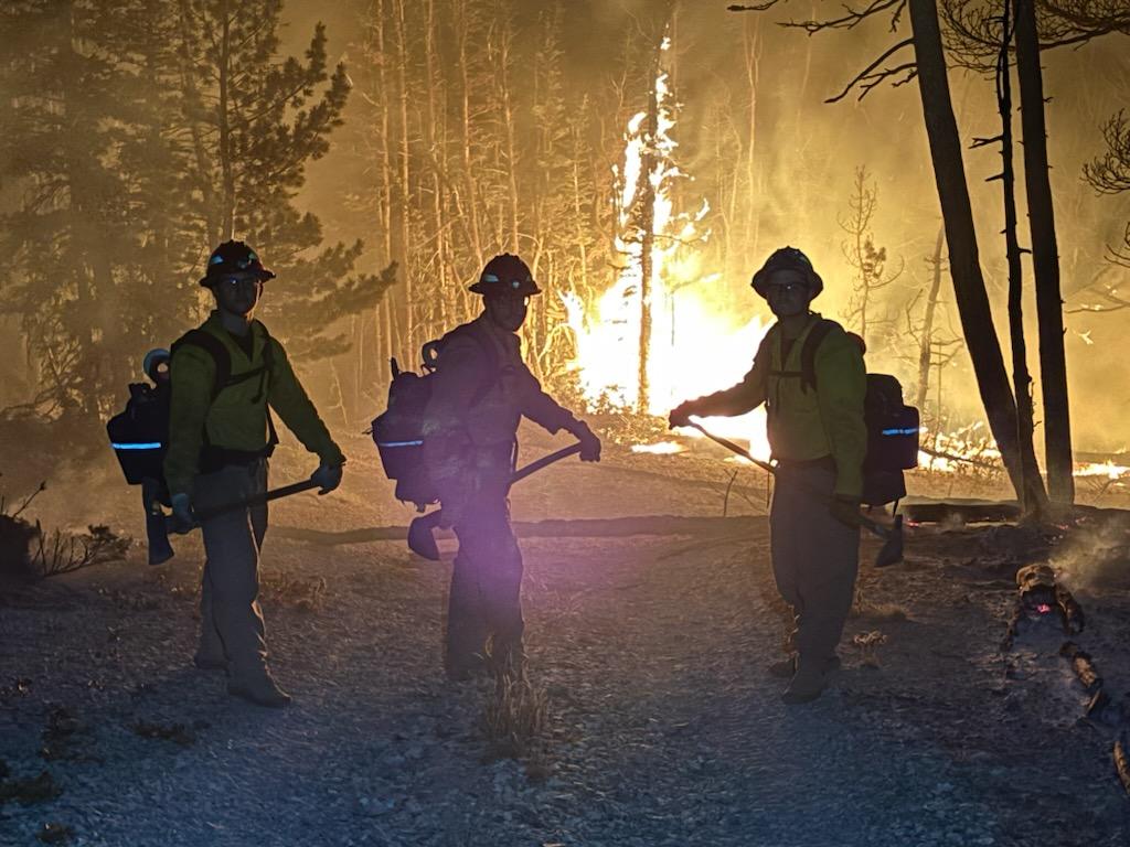
On Friday, July 5, 2024, at approximately 1:00 p.m., the Silver King Fire, burning on the Fishlake National Forest approximately three miles west of the Town of Marysvale, UT was reported. The fire cause is natural, due to a lightning strike. It is burning in heavy timber, Pinyon-Juniper, sagebrush and grass. The fire is currently being managed by Great Basin Complex Incident Management Team 2 utilizing full suppression, confine/contain and value protection strategies.
Incident Objectives include:
- The lives and safety of the public, firefighters, and aviators will always be the highest priority throughout all phases of the incident. Only choose strategies and tactics that will result in the highest probability of success in achieving incident objectives and course of action while minimizing risk to firefighters.
- Protect water quality in watersheds, water systems, riparian zones, springs, and seeps by limiting fire intensities and utilizing suppression activities to minimize sedimentation.
- Minimize loss to private property, infrastructure, communication sites, transportation corridors and transmission lines by restricting fire growth north, east and south of current perimeters.
- Maintain and enhance relationships with local communities, cooperators, and visiting public by providing timely and accurate information utilizing all applicable methods.
- Use natural barriers, constructed features, and favorable fuel types that will provide the greatest possibility for suppression success.
| Current as of | Thu, 08/01/2024 - 09:13 |
|---|---|
| Incident Time Zone | America/Denver |
| Incident Type | Wildfire |
| Cause | Lightning |
| Date of Origin | |
| Location | 3 Miles West of Marysvale, Utah |
| Incident Commander | Sierra Front Nevada Team 5 Scott Stephenson, Incident Commander Benjamin Krupski, Incident Commander (trainee) August Isernhagen, Deputy Incident Commander |
| Coordinates |
38° 29' 01'' Latitude
-112° 20' 26
'' Longitude
|
| Total Personnel: | 157 |
|---|---|
| Size | 18,222 Acres |
| Percent of Perimeter Contained | 88% |
| Estimated Containment Date | 10/1/2024 |
| Fuels Involved | The Silver King Fire fuels consist of heavy timber, pinyon-juniper, grass & sagebrush. |
| Significant Events | Decrease in humidity causing low fire behavior with isolated torching. Potential could increase from outflow winds from thunderstorms that do not produce much rain. |
| Planned Actions |
Resources continue to monitor the west and southern edges of the fire. Division A continues to mop-up problematic areas of concern and has begun dozer line repair work. Division K will continue has completed suppression repair and will continue to monitor. Division T continues to monitor and secure edges as weather opportunities present. |
|---|
| Weather Concerns | A ridge of high pressure continues to build into the area and will remain in place through Saturday. This will favor terrain-driven winds except for periods where thunderstorms outflow winds may be encountered. On Thursday, winds will turned northerly in the afternoon. Where winds and terrain align the up-valley northerly winds will be enhanced. However, winds are not expected to be exceptionally strong, with worst case scenario valley afternoon gusts approaching 20 mph late in the afternoon or early evening. Signs of incoming monsoonal moisture will be observed by late in the afternoon and evening. Little change in surface relative humidity is expected. The Silver King fire will reside on the northern fringes of the better moisture on Friday, with a 15% chance of an isolate dry shower or thunderstorm. Moisture will become more plentiful by Saturday, when modest RH recovery is expected, with a chance of wetting rain around 25% and LAL of 4 by the afternoon. Thunderstorms will transition to more of a wet variety by Saturday evening through the weekend. |
|---|