
Highlighted Activity
Highlighted Media

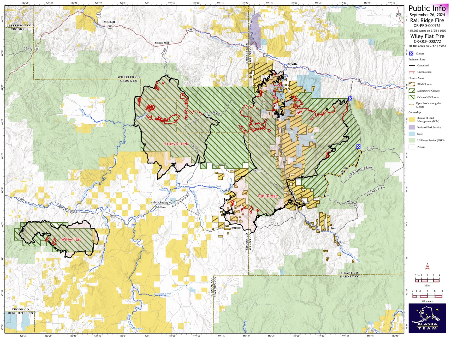
The Rail Ridge Fire is comprised of multiple lightning fires that ignited on September 2, 2024 and merged into one. It’s located 51 miles northwest of Burns, Oregon and has been burning in grass and shrubs in lower elevations, and timber in higher elevations. The fire is primarily burning on lands managed by Bureau of Land Management, Malheur National Forest, and Ochoco National Forest.
For Current Evacuation Levels in all counties, please visit this link for more information.
Closures: The U.S. Forest Service and Bureau of Land Management have implemented closures in the area of the Rail Ridge Fire. For more details and closure maps, click here.
| Current as of | Thu, 09/26/2024 - 13:22 |
|---|---|
| Incident Time Zone | America/Los_Angeles |
| Incident Type | Wildfire |
| Cause | Lightning |
| Date of Origin | |
| Location | Less than 1 mile south of Dayville, OR |
| Incident Commander | Alaska Team 3 assumed command of the Rail Ridge Fire with Incident Commander Jake Livingston, and Incident Commander Trainee Jason Devcich. |
| Coordinates |
44° 14' 27'' Latitude
-119° 33' 35
'' Longitude
|
| Total Personnel: | 1239 |
|---|---|
| Size | 165,209 Acres |
| Percent of Perimeter Contained | 61% |
| Fuels Involved | Timber (Grass and Understory) Brush (2 feet) Timber (Litter and Understory) Fuels in the fire area are composed of various loadings of Grass/ Shrubs, Timber with Litter and Understory models. Live woody and herbaceous fuels are seasonally dry and contributing to rates of spread; grasses fully cured. Higher elevations are dominated by conifer stands; lower slopes and harsh sites transition to shrubs and grass. |
| Significant Events | Moderate Backing Creeping Smoldering A cold front passage brings strong southwest winds that will shift to northwest later in the day. The cold front also brings increasing clouds with a slight chance of thunderstorm to the area. Forecast weather provides conditions that support rapid fire spread where a source of heat and available fuels are present. Portions of the fire show widely scattered interior heat sources as heavy fuels (stump holes, log ends) continue to consume due to long-term drying. |
| Planned Actions |
The prioritization of incident management objectives continues to be: 1) Fire suppression: look for opportunities to go direct on the fire perimeter, and safely construct fire line. Utilize firing operations to improve potential control features and fire line. 2) Mop up and patrol: mop up along containment lines, focusing on areas with the highest potential to threaten the containment lines. 3) Suppression repair: continue to implement the approved suppression repair plan. Suppression repair activity during the current operational period is slowed by the limited number of READs and the prioritization of fire suppression, mop-up and patrol. Future suppression repair activity will advance more quickly if those critical READ positions were filled now (as those READs would assess and prescribe suppression repair needs for fire suppression features that are currently in-use). |
|---|---|
| Projected Incident Activity |
12 Hours: Continued warm, very dry, and windy as a strong cold front cross the fire area. Gusty southwest winds will transition to northwest, with increasing clouds in the afternoon. Strong gusty wind provides elevated fire weather conditions that may increase fire behavior potential. Forecast conditions will support rapid fire spread where available fuels and a source of heat are present. Interior flare ups are possible as smoldering fuels kindle to flame with wind. Fire behavior may include rapid surface fire spread, torching, and spotting. Isolated interior heavy fuels will continue to smolder and consume in-place until extinguished or sufficient moisture occurs. 24 Hours: Slightly cooler but continued dry weather and breezy conditions will maintain very dry fuels in the fire area. Low relative humidity may result in scattered interior flare-ups where a source of heat and available fuels are present. Conditions will support fire spread. Fire behavior will likely consist of smoldering, and creeping with limited activity. Isolated heavy fuels will continue to smolder and consume in-place until extinguished or sufficient moisture occurs. 48 Hours: Continued cool and dry weather is expected that will maintain conditions to support moderate to active fire behavior where a source of heat is present. Light winds and fair nighttime relative humidity may moderate fire behavior. Isolated heavy fuels (stump holes, log ends) will continue to smolder due to their seasonal dryness. Diminishing threat of fire activity as aggressive mop up occurs and residual sources of heat consume in place. 72 Hours: Cool temperatures, very low relative humidity, and breezy conditions will continue to support moderate to active fire behavior where a source of heat is present. Isolated heavy fuels (stump holes, log ends) will continue to smolder due to their seasonal dryness. Diminishing threat of fire activity as residual sources of heat consume in place. Anticipated after 72 hours: Expect continued warm and dry conditions that may support moderate to active fire behavior where a source of heat and available fuels are present. Isolated heavy fuels (stump holes, log ends) will continue to smolder due to their seasonal dryness. Diminishing threat of fire activity as residual sources of heat consume in place. |
| Remarks |
Evacuations — For the most up-to-date evacuation information, please visit:
Closures:
Fire Restrictions –
|
| Weather Concerns | Wednesday morning conditions started out dry and warm, with general winds out of the southwest. Around noon, southwest winds began to increase over the fire area to 10 to 25 mph gusting to 30 to 40 mph as cumulus buildups occurred ahead of the front. No measurable rain occurred with the passing showers, but winds were gusty throughout the afternoon. Winds began to shift out of the west mid afternoon. After the passing of the cold front, northwest winds will establish for the evening and terrain-driven winds will return during the nighttime hours. Cooler temperatures are expected Thursday with light diurnally driven winds. Weak high pressure establishes over the area Friday and Saturday allowing for warming and drying conditions. |
|---|