
Highlighted Activity
Highlighted Media
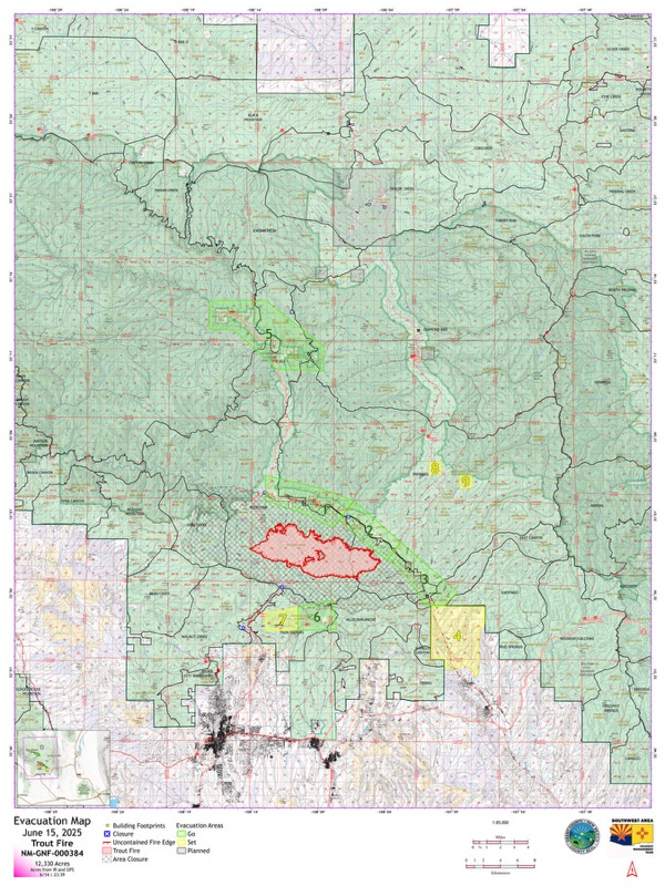
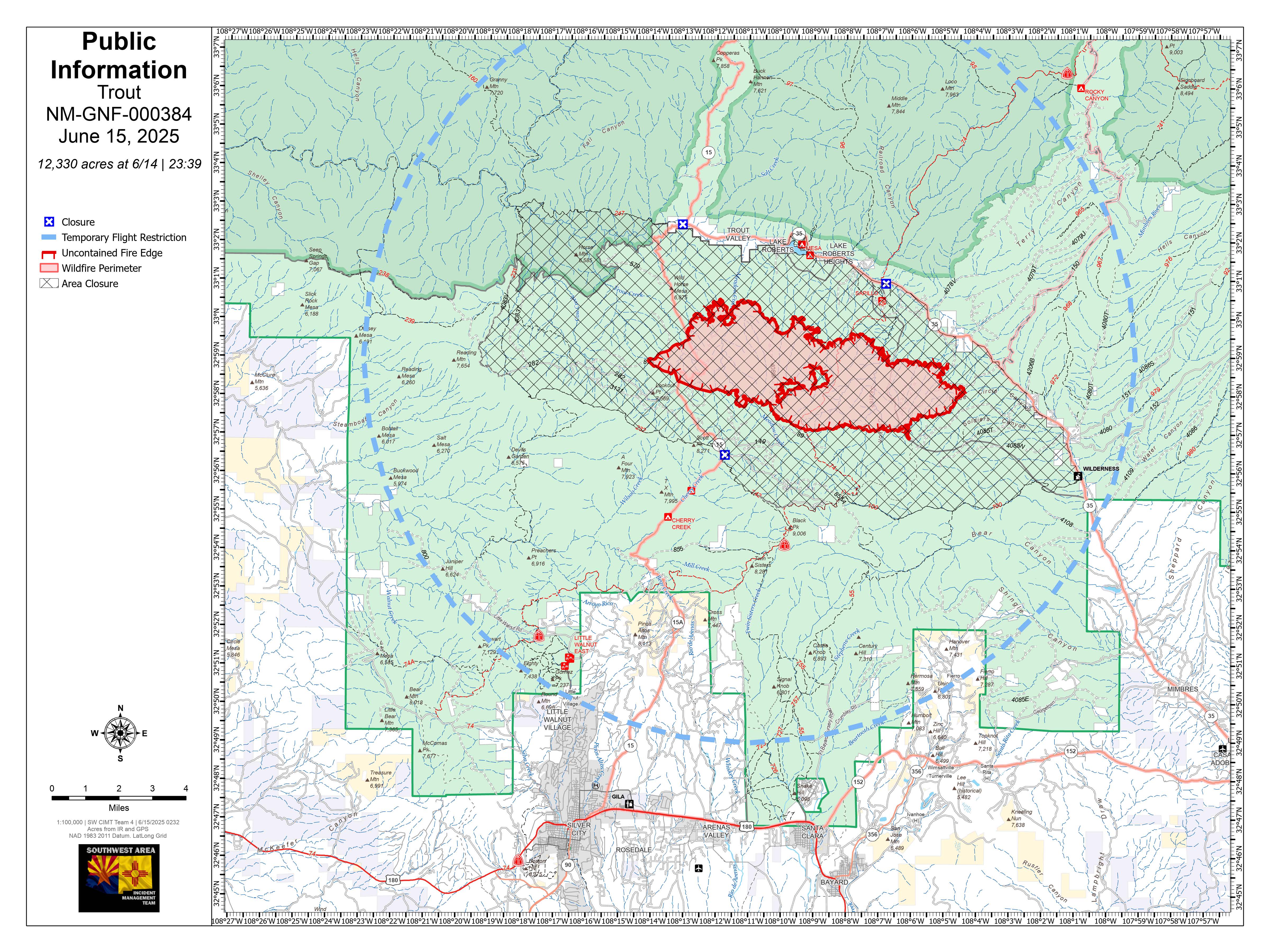
Trout Fire Public Information Map for June 15, 2025
The fire was reported Thursday, June 12, in the Trout Creek area of the Gila National Forest. Driven by hot, dry weather, the fire quickly grew and crossed NM-15 in the afternoon. Command of the fire transferred command to the Gila/Las Cruces Type 3 team Thursday evening. Saturday morning, command will again transfer to a complex incident management team, Southwest Team 4. Resources working the fire include hot shot crews, type 2 hand crews, dozers, helicopters and fixed wing aircraft.
The Gila National Forest has implemented a closure order. Find the details of the closure in the "Closures" tab of this page.
| Current as of | Sun, 06/15/2025 - 22:11 |
|---|---|
| Incident Time Zone | Mountain Standard Time |
| Incident Type | Wildfire |
| Cause | undetermined |
| Date of Origin | |
| Incident Time Zone | Mountain Standard Time |
| Location | 12 miles north of Silver City |
| Incident Commander | Andrew Mandell, Southwest Incident Management Team 4 |
| Coordinates |
32° 58' 46'' Latitude
-108° 13' 58
'' Longitude
|
| Total Personnel: | 552 |
|---|---|
| Size | 12,330 Acres |
| Percent of Perimeter Contained | 0% |
| Fuels Involved |
|
| Significant Events | Active fire behavior has been observed including running, short-range spotting and torching. |
| Planned Actions |
Continue to hold and secure completed line. Prep Highway 15 for potential burnout operations on the SW portion of the fire. On northern portion of the fire: Improve and construct indirect line and continue with prep work around structures in the Lake Roberts area. To the northeast portion of the fire: Scout and explore fireline opportunities to minimize fire spread and size. East of the fire: Continue scouting ahead of the fire for potential holding features utilizing existing roads where possible to minimize spread to the east towards Mimbres Valley. South side of the fire: Utilize heavy equipment to construct fireline using existing roads where possible. |
|---|---|
| Projected Incident Activity |
In the coming hours and days, fire is projected to continue moving north and east, depending on wind direction and other weather conditions. Wind shifts are predicted to spread then east and south into the weekend. |
| Remarks |
Evacuations: GO (Level 3) – Zones 1, 2, 3, 5, 6; SET (Level 2) – Zone 7; READY (Level 1) – Zone 4. Additional evacuation areas will be identified as the situation evolves. On Saturday, June 14, Grant County Sheriff’s Office and New Mexico State Police issued new evacuation orders. Residents are urged to stay informed of evacuation status, as conditions may change quickly. An evacuation shelter is available at the Convention Center in Silver City (3031 Highway 180 East, Silver City, NM). High Desert Humane Society will accommodate pets and the rodeo grounds at the Southwest Horseman's Association are open to receive livestock. The Gila National Forest has also closed part of the forest in the area of the fire. Check the agency's website and the "Closures" tab of this page for details. |
| Weather Concerns | Hot temperatures are forecasted to continue through the week ahead. Combined with and very low relative humidity and low fuel moisture levels, fire conditions will remain elevated into much of next week. Winds most days are predicted to be relatively light until breezes pick up Monday and Tuesday, creating critical fire conditions. |
|---|