
Highlighted Media
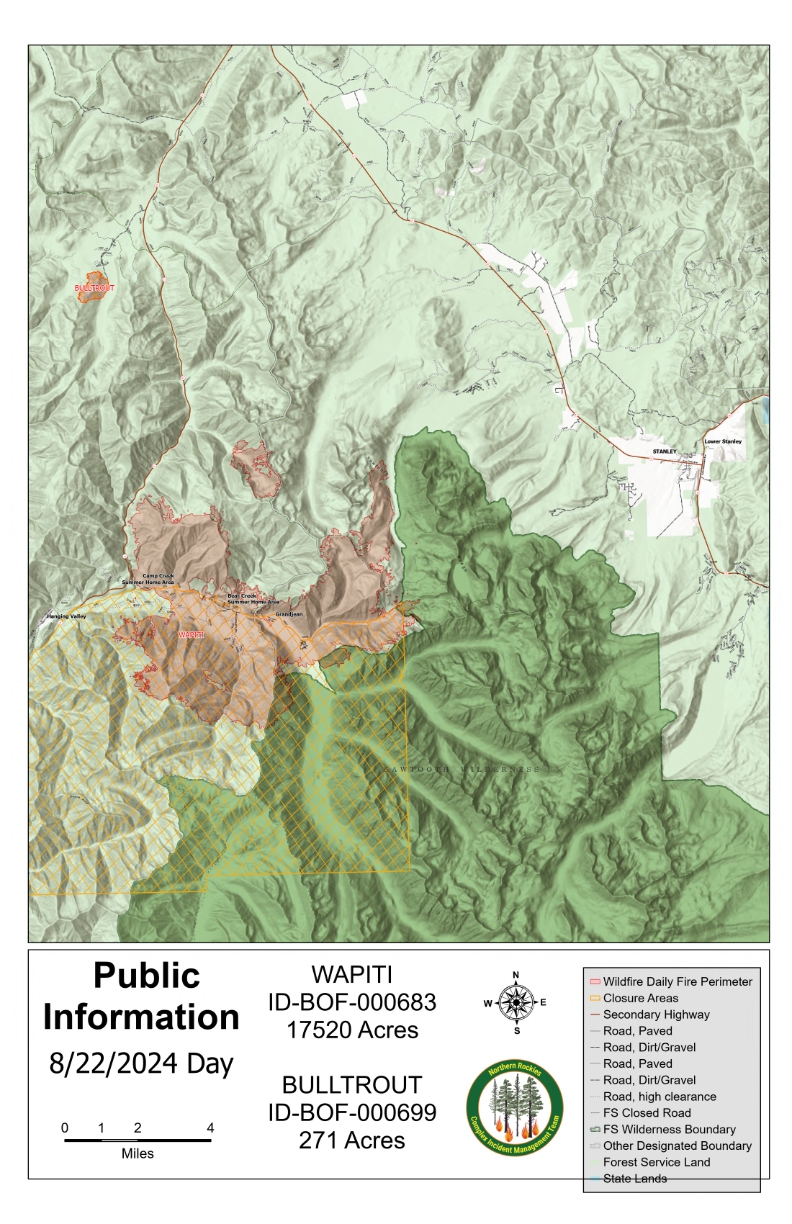
Bull Trout Fire Map Thursday, August 22, 2022
The Bulltrout fire was started by lightning on the evening of July 24, 2024, approximately 35 miles northeast of Lowman along Idaho State Highway 21. Steep terrain, difficult access and unfavorable weather conditions encouraged fire spread. The Boise National Forest managed the fire until a Complex Incident Management Team was requested.
The Northern Rockies Complex Management Team 5, Rick Connell Incident Commander assumed command of Bull Trout Fire on August 10, 2024 at 6 AM along with the Wapiti Fire and the Middle Fork Complex (Bulldog, Nellie, and Anderson).
Currently no evacuations have been ordered. As of August 12th there is a closure around the fire perimeter in effect; please avoid the fire area so that fire suppression efforts are not impacted. https://www.fs.usda.gov/alerts/boise/alerts-notices
The Boise National Forest, Idaho Department of Lands, and Bureau of Land Management are in Stage 1 fire restrictions on state, endowment, private and federal lands within the West Central Mountains Fire Restrictions Zone. For more information, visit the Idaho fires Restrictions website at: https://www.idl.idaho.gov/fire-management/fire-restrictions-finder/
Fire Information Contact Information: 2024.MiddleForkComplex@firenet.gov or call 208-992-3045
| Current as of | Sat, 08/24/2024 - 22:44 |
|---|---|
| Incident Time Zone | America/Boise |
| Incident Type | Wildfire |
| Cause | Lightning/Natural |
| Date of Origin | |
| Location | 15 miles WNW OF Stanley, ID |
| Incident Commander | Rick Connell, Incident Commander, Northern Rockies Complex Incident Management Team #5 Craig Glazier, Deputy Incident Commander |
| Coordinates |
44° 17' 38'' Latitude
-115° 15' 36
'' Longitude
|
| Total Personnel: | 0 |
|---|---|
| Size | 271 Acres |
| Percent of Perimeter Contained | 92% |
| Estimated Containment Date | 09/01/2024 |
| Fuels Involved | Subalpine fir, snowberry, sagebrush, perennial grasses. Steep terrain. ERC values remain near the 90th percentile. |
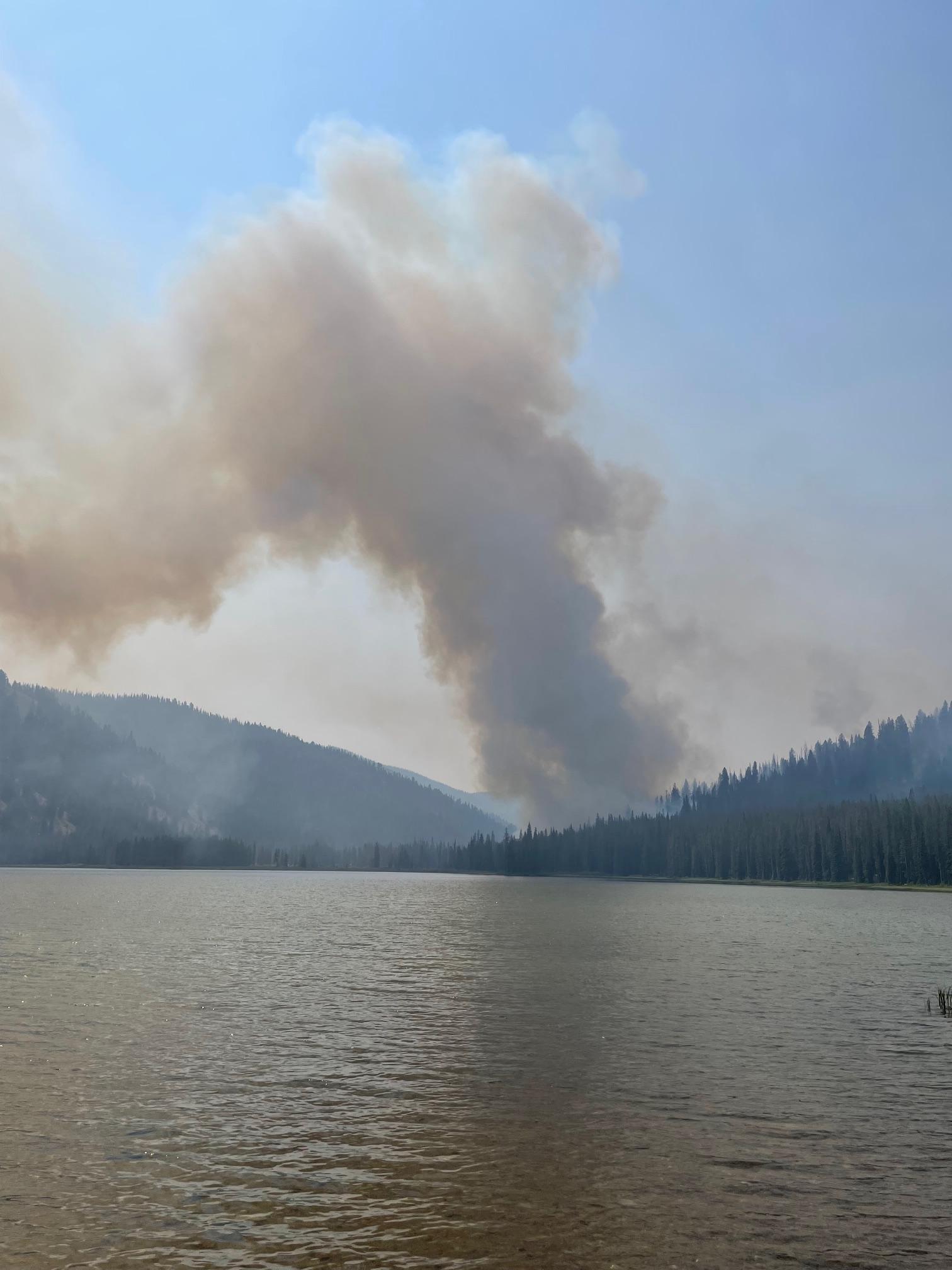
| Significant Events | Minimal fire activity was observed. Smoldering as heavy fuels continue to consume. Little threat to containment lines exist. |
| Planned Actions |
Monitor and patrol the fire area. |
|---|---|
| Projected Incident Activity |
The probabilty of fire activity is low. Smoldering fire behavior. Fire spread outside of control lines is not expected. |
| Remarks |
This incident in being managed by the Northern Rockies Complex Management Team 5 along with the Wapiti Fire and the Middle Fork Complex (Bulldog and Nellie). The resource commitment summary reflects resources that have been ordered to this incident. |
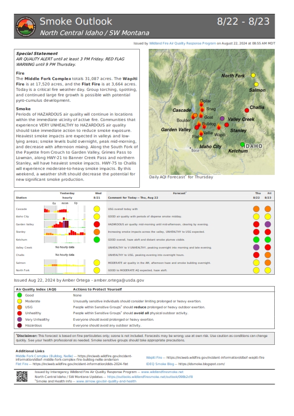
| Weather Concerns | A Red Flag Warning for very low humidity and gusty south winds is in effect for the area. As the inversion lifted by early afternoon RH fell into the 10-15% range across all elevations and temperatures warmed into the 80s to mid-90s. General south winds increased during the afternoon, with gusts in excess of 25 mph along exposed upper ridgelines as well as through aligned drainages. These dry and breezy conditions will persist through the evening and potentially into the overnight hours, resulting in marginal to poor overnight RH recovery. South winds will strengthen Friday morning ahead of an approaching cold front, gusting in excess of 30 mph at times. RH values will remain in the mid to upper teens through much of the day. The cold front will cross the area late Friday afternoon into Friday evening resulting in a wind shift to the west. Much cooler temperatures along with higher RH and a chance for showers will follow for the weekend. |
|---|